Hail Map in North Carolina on August 14, 2023
Get this storm
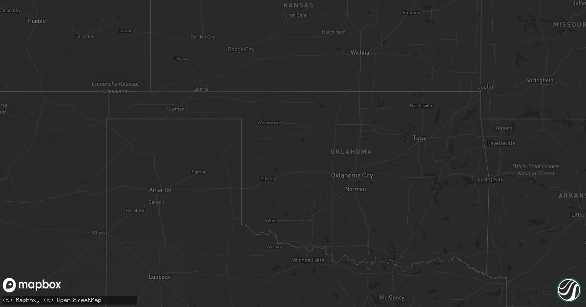
August 14 map
$229
one time, instant access
Download today. No call, no setup
Keep the $229
Bought the map and want the full workflow? Apply the entire $229 to a subscription within 7 days. None of it is wasted.
Every map, not just this one
This buys you this map. Subscription and you get every map we run, in the markets you choose from a few cities to whole states to nationwide. Plus real-time alerts the moment a storm fires.
Contact data
Name, contact info, occupancy, even credit band for addresses in the footprint. You go from where it hit to who to call.
Become the source they trust
Unlimited branding weather history reports on demand. You already have the documented answer ready for the property owner, and you are the one who showed up with it.
Property data and RoofTrace estimates
Pull up any address you have got, its value and the exact code rules for that jurisdiction, straight from One Click Code. Then RoofTrace estimates the squares, pitch, and roof value, priced the way you price.
Storm reports in North Carolina
North Carolina
| Date | Description |
|---|---|
| 08/14/20233:26 PM CDT | Powerlines down in the area causing over 1k customers with out power. |
| 08/14/20233:22 PM CDT | Tree reported down on road. |
| 08/14/20233:20 PM CDT | Tree down on central ave. |
| 08/14/20233:20 PM CDT | Trees down at childress vineyards. |
| 08/14/20233:20 PM CDT | Tree down on martin street. |
| 08/14/20233:20 PM CDT | Tree down on spruce street. |
| 08/14/20233:20 PM CDT | 911 call center reported powerlines down on judge rd and warrior dr. |
| 08/14/20233:19 PM CDT | Tree down near rowe rd and us 64. |
| 08/14/20233:15 PM CDT | Duke energy reports fallen trees leading to power outage on thermal view dr. |
| 08/14/20232:45 PM CDT | Tree down on car near sheffield. |
| 08/14/20231:45 AM CDT | Multiples trees down in elkin. |
| 08/14/20231:41 AM CDT | Numerous trees down in the vicinity of pleasant hill in far eastern wilkes county. |
| 08/14/20231:29 AM CDT | Tree down across austin little mountain road. |
| 08/14/202312:15 AM CDT | A wood framed wall was blown down near high school drive. Time estimated using radar. |
| 08/14/202312:10 AM CDT | Large limbs downed and roof damage in vilas. |
| 08/14/202312:00 AM CDT | Fairview road and pisgah road whole tree down blocking both lanes of road. |
| 08/13/202311:55 PM CDT | Large limbs blown down along buckeye ridge road. |
| 08/13/202310:11 PM CDT | 2 or 3 trees down not far from the tennessee border. |
All States Impacted by Hail Map on August 14, 2023
Cities Impacted by Hail Map on August 14, 2023
- Climax, GA
- Jacksonville, FL
- Crawfordville, FL
- Lawtey, FL
- Starke, FL
- Thomson, IL
- Chadwick, IL
- Sublette, IL
- Amboy, IL
- Savanna, IL
- Mount Carroll, IL
- Lake Butler, FL
- Branford, FL
- Hillsboro, TX
- Axis, AL
- Harmon, IL
- Dixie, GA
- Boston, GA
- Dixon, IL
- Rock Falls, IL
- Sumner, GA
- Sylvester, GA
- Gainesville, FL
- Clinton, IA
- Sabula, IA
- Fabens, TX
- Ty Ty, GA
- Saint George, GA
- Bryceville, FL
- Macclenny, FL
- Brooker, FL
- Sopchoppy, FL
- Alachua, FL
- Mount Hamilton, CA
- Etowah, TN
- Delano, TN
- Leoma, TN
- Estillfork, AL
- Athens, TN
- Cleveland, TN
- Calhoun, TN
- Charleston, TN
- Corryton, TN
- Decatur, TN
- Corsicana, TX
- Meridian, TX
- Iredell, TX
- Fayetteville, TN
- Sale Creek, TN
- Mount Morris, IL
- Riceville, TN
- Milledgeville, GA
- Hamilton, TX
- New Market, AL
- Hazel Green, AL
- Hackleburg, AL
- Paicines, CA
- Frost, TX
- Cookeville, TN
- Baxter, TN
- Silver Point, TN
- Smithville, TN
- Danville, AL
- Decatur, AL
- Trinity, AL
- Moulton, AL
- Homerville, GA
- Eatonton, GA
- Tupelo, MS
- Georgetown, TN
- Abbott, TX
- Toney, AL
- Meridianville, AL
- Evant, TX
- Birchwood, TN
- Mertens, TX
- Englewood, TN
- La Moille, IL
- Mullin, TX
- Goldthwaite, TX
- Pottsville, TX
- Cranfills Gap, TX
- Harrison, TN
- Oliver Springs, TN
- Tallassee, AL
- Monticello, GA
- Montgomery, AL
- Strawberry Plains, TN
- Moyock, NC
- Tutwiler, MS
- Hamilton, AL
- Vina, AL
- Knoxville, TN
- Whigham, GA
- Milford, TX
- Italy, TX
- Blooming Grove, TX
- Pulaski, TN
- Dellrose, TN
- Frankewing, TN
- Clinton, TN
- Elora, TN
- Flintville, TN
- Robbinsville, NC
- Hillsboro, AL
- Athens, AL
- Andrews, NC
- Tanner, AL
- Madison, AL
- Leighton, AL
- Town Creek, AL
- Tellico Plains, TN
- Huntsville, AL
- Taft, TN
- Graysville, TN
- Mascot, TN
- Blaine, TN
- Luttrell, TN
- Courtland, AL
- Rosedale, MS
- Ronda, NC
- Roaring River, NC
- Ardmore, TN
- Hollytree, AL
- Hollywood, AL
- Belvidere, TN
- Huntland, TN
- Kelso, TN
- Harvest, AL
- Princeton, AL


