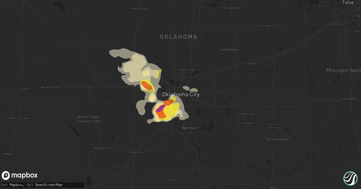
Hail Map in Oklahoma City, OK on August 14, 2018
Get this storm
August 14 map
$229
one time, instant access
Download today. No call, no setup
Keep the $229
Bought the map and want the full workflow? Apply the entire $229 to a subscription within 7 days. None of it is wasted.
Every map, not just this one
This buys you this map. Subscription and you get every map we run, in the markets you choose from a few cities to whole states to nationwide. Plus real-time alerts the moment a storm fires.
Contact data
Name, contact info, occupancy, even credit band for addresses in the footprint. You go from where it hit to who to call.
Become the source they trust
Unlimited branding weather history reports on demand. You already have the documented answer ready for the property owner, and you are the one who showed up with it.
Property data and RoofTrace estimates
Pull up any address you have got, its value and the exact code rules for that jurisdiction, straight from One Click Code. Then RoofTrace estimates the squares, pitch, and roof value, priced the way you price.
Storm reports in Oklahoma City, OK
Oklahoma City, OK
| Date | Description |
|---|---|
| 08/14/20186:46 PM CDT | A local report indicates 1.00 inch wind near 4 SSW WILL ROGERS AIRPO |
| 08/14/20186:20 PM CDT | A local report indicates 1.00 inch wind near 2 S WILL ROGERS AIRPORT |
| 08/14/20186:00 PM CDT | 2 power poles down 2 blocks east of council and hwy 152 |
| 08/13/20187:55 PM CDT | 2 to 3 feet diameter tree blown down. |
All States Impacted by Hail Map on August 14, 2018
All Cities Impacted by Hail Map on August 14, 2018
- Cordell, OK
- Fort Lupton, CO
- Longmont, CO
- Berthoud, CO
- Erie, CO
- Frederick, CO
- Brighton, CO
- Dacono, CO
- Butler, OK
- Clinton, OK
- Foss, OK
- Minco, OK
- Union City, OK
- Springer, NM
- Pampa, TX
- Binger, OK
- Lone Wolf, OK
- Lyons, CO
- Seligman, AZ
- Florissant, CO
- Okabena, MN
- Lakefield, MN
- Yukon, OK
- Oklahoma City, OK
- Spencer, OK
- Irvington, AL
- Aguilar, CO
- La Veta, CO
- Walsenburg, CO
- Groom, TX
- White Deer, TX
- Claude, TX
- Mustang, OK
- Wheatland, OK
- Tuttle, OK
- Newcastle, OK
- Gracemont, OK
- Safford, AZ
- Cripple Creek, CO
- Okarche, OK
- Kingfisher, OK
- Meno, OK
- Geary, OK
- Greenfield, OK
- Pima, AZ
- Thatcher, AZ
- Niagara, WI
- Anadarko, OK
- Newcastle, WY
- Spooner, WI
- Shell Lake, WI
- Hereford, TX
- Canyon, TX
- Williams, AZ
- Paullina, IA
- Sutherland, IA
- Primghar, IA
- Clearmont, WY
- Sylvania, GA
- Rock River, WY
- Hobart, OK
- Blair, OK
- Sentinel, OK
- Viborg, SD
- Belle Fourche, SD
- Saint Onge, SD
- Montrose, SD
- Custer City, OK
- Dimmitt, TX
- Nazareth, TX
- Hodgen, OK
- Holly Springs, NC
- Fuquay Varina, NC
- Oakfield, GA
- Belhaven, NC
- Round O, SC
- Story, WY
- Calumet, IA
- Elmer, OK
- Altus, OK
- Walterboro, SC
- Cottageville, SC
- Pearce, AZ
- Casper, WY
- Lookeba, OK
- Benson, AZ
- Miami, TX
- Portal, GA
- Statesboro, GA
- Ashton, IA
- Sanborn, IA
- Melvin, IA
- Aurora, NC
- Bailey, CO
- Gardner, CO
- Rimrock, AZ
- El Reno, OK
- Mormon Lake, AZ
- Florence, WI
- Elk City, OK
- Cheyenne, WY
- Laramie, WY
- Mangum, OK
- Las Vegas, NM
- Freeman, SD
- Hinton, OK
- Grandfield, OK
- Devol, OK
- Bosler, WY
- Taloga, OK
- Putnam, OK
- Panhandle, TX
- Littleton, CO
- Lone Tree, CO
- Hill City, SD
- Corn, OK
- Colony, OK
- Boulder, CO
- Americus, GA
- Piedmont, OK
- Isanti, MN
- Marion, AL
- Dover, OK
- Loyal, OK
- Hennessey, OK
- Gotebo, OK
- Weatherford, OK
- Lead, SD
- Worthington, MN
- Bridgewater, SD
- Lismore, MN
- Wilmont, MN
- Mountain View, OK
- Loveland, CO
- Lovell, WY
- Bylas, AZ
- Cochise, AZ
- Golden, CO
- Okeene, OK
- Battleboro, NC
- Whitakers, NC
- Elk River, MN
- Owatonna, MN
- Sayre, OK
- Carter, OK
- Roper, NC
- Westcliffe, CO
- Raton, NM
- Green Pond, SC
- Denver, CO
- Morrison, CO
- Calumet, OK
- Pine, AZ
- Wickenburg, AZ
- Congress, AZ
- Watonga, OK
- Elk City, KS
- Amarillo, TX
- Granite, OK
- Willow, OK
- Elfrida, AZ
- Hardeeville, SC
- Felch, MI
- Fort Stewart, GA
- Mobile, AL
- Grand Bay, AL
- Firestone, CO
- Sheridan, WY
- Norman, OK
- Opelika, AL
- Auburn, AL
- Early Branch, SC
- Banner, WY
- Drake, CO
- Kingman, AZ
- Wolf, WY
- Drummond, OK
- Lahoma, OK
- Fairview, OK
- Flagstaff, AZ
- Blountstown, FL
- Buffalo, WY
- Big Horn, WY
- Wyarno, WY
- Creswell, NC
- Show Low, AZ
- Ralston, OK
- Sibley, IA
- Weston, CO
- Leedey, OK
- Bisbee, AZ
- Lake Park, IA
- Harris, IA
- Borger, TX
- Guffey, CO
- Hemingway, SC
- Wellston, OK
- Cashion, OK
- Fairmont, OK
- Douglas, OK
- Spirit Lake, IA
- Gillette, WY
- Luther, OK
- Meridian, OK
- Ridgeville, SC
- Cross, SC
- Penrose, CO
- Bellvue, CO
- Headrick, OK
- Hammon, OK
- Pollocksville, NC
- Ault, CO
- Casa Grande, AZ
- Canton, OK
- Blue Earth, MN
- Prescott, AZ
- Black Canyon City, AZ
- Lake George, CO
- Chester, OK
- Fort Mcdowell, AZ
- Watkins, CO
- Smithville, GA
- Leslie, GA
- Electra, TX
- Arapaho, OK
- Ames, OK
- Chandler, OK
- Hydro, OK
- Divide, CO
- Carnegie, OK
- Canadian, TX
- Akron, IA
- Andrews, SC
- Georgetown, SC
- Willcox, AZ
- Theodore, AL
- Nashville, NC
- Happy, TX
- Cornville, AZ
- Cottonwood, AZ
- Trementina, NM
- Hartley, IA
- Dell Rapids, SD
- Wells, MN
- Alcova, WY
- Blanchard, OK
- Kingsford, MI
- Saint Stephen, SC
- Ranchester, WY
- Ocheyedan, IA
- Columbia, NC
- Sedona, AZ
- Independence, KS
- Kinross, MI
- Milford, IA
- Luverne, MN
- Kenneth, MN
- Reading, MN
- Winter, WI
- Angier, NC
- Sedalia, CO
- Heavener, OK
- Salem, SD
- Irene, SD
- Yulee, FL
- Callahan, FL
- San Simon, AZ
- Olustee, OK
- Wetmore, CO
- Rio Verde, AZ
- Brantingham, NY
- Victor, CO
- Washington, OK
- Dill City, OK
- Stone Lake, WI
- Arvada, CO
- Jamestown, SC
- Bonneau, SC
- Monticello, MN
- Evergreen, CO
- Payson, AZ
- Mission Hill, SD
- Varnville, SC
- Yemassee, SC
- Conifer, CO
- Pine, CO
- Mellen, WI
- Skellytown, TX
- Port Wentworth, GA
- Carthage, NC
- Winfred, SD
- Rocky Mount, NC
- Humboldt, SD
- Pawnee, OK
- Seiling, OK
- Fairmont, MN
- Brewster, MN
- Bessie, OK
- Canute, OK
- Summerville, SC
- Wildorado, TX
- Hart, TX
- Rincon, GA
- Guyton, GA
- Briggsdale, CO
- Grover, CO
- Pocasset, OK


