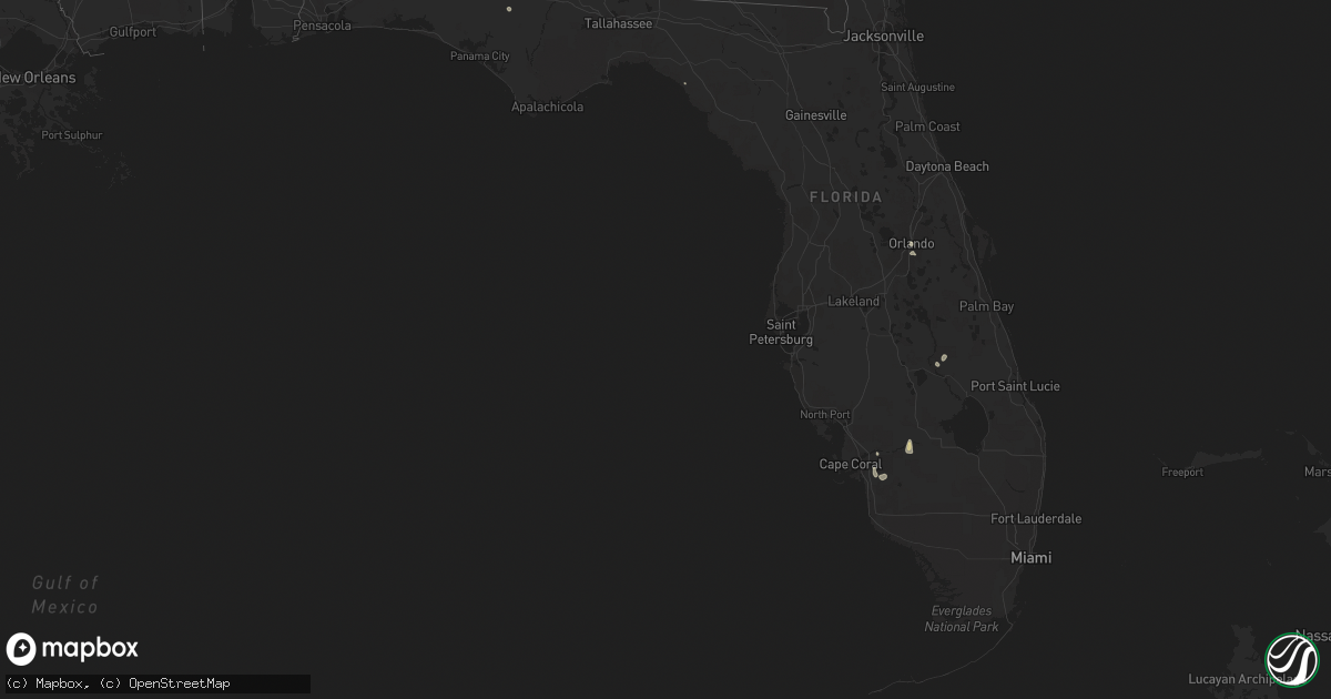
Hail Map in Florida on August 14, 2015
Get this storm
August 14 map
$229
one time, instant access
Download today. No call, no setup
Keep the $229
Bought the map and want the full workflow? Apply the entire $229 to a subscription within 7 days. None of it is wasted.
Every map, not just this one
This buys you this map. Subscription and you get every map we run, in the markets you choose from a few cities to whole states to nationwide. Plus real-time alerts the moment a storm fires.
Contact data
Name, contact info, occupancy, even credit band for addresses in the footprint. You go from where it hit to who to call.
Become the source they trust
Unlimited branding weather history reports on demand. You already have the documented answer ready for the property owner, and you are the one who showed up with it.
Property data and RoofTrace estimates
Pull up any address you have got, its value and the exact code rules for that jurisdiction, straight from One Click Code. Then RoofTrace estimates the squares, pitch, and roof value, priced the way you price.
Storm reports in Florida
Florida
| Date | Description |
|---|---|
| 08/14/20155:07 PM CDT | Power line down on orange hill road just south of gilberts mill |
| 08/14/20153:15 PM CDT | Power line also down near blairstone and apalachee. Reported by retired usaf meteorologist. Also 6 inches of water on the road. |
| 08/14/20153:15 PM CDT | Tree down on power line near the intersection of woodward and brevard street |
| 08/14/20153:15 PM CDT | Picture submitted on social media of a tree down on a power line along redbud ave |
All States Impacted by Hail Map on August 14, 2015
Cities Impacted by Hail Map on August 14, 2015
- Comstock, TX
- Appleton, WI
- Neenah, WI
- Hortonville, WI
- Greenville, WI
- Larsen, WI
- Seymour, WI
- Shiocton, WI
- Black Creek, WI
- Decatur, IN
- Craigville, IN
- Ossian, IN
- Little Suamico, WI
- Suamico, WI
- Sobieski, WI
- Abrams, WI
- Green Bay, WI
- Krakow, WI
- Pulaski, WI
- Loraine, TX
- Hermleigh, TX
- Stanton, TX
- Midland, TX
- Evansville, WI
- Tripoli, WI
- Unionville, MI
- Akron, MI
- Bark River, MI
- Florence, MT
- Glennie, MI
- Labelle, FL
- Crossroads, NM
- Markesan, WI
- Remus, MI
- Rodney, MI
- Mecosta, MI
- Evart, MI
- Chippewa Lake, MI
- South Branch, MI
- Curran, MI
- Sterling, MI
- Whittemore, MI
- Twining, MI
- Prescott, MI
- Turner, MI
- Little Lake, MI
- Rock, MI
- Mertzon, TX
- San Angelo, TX
- Carlsbad, TX
- Bonduel, WI
- Green Valley, WI
- Oconto, WI
- De Pere, WI
- Lena, WI
- Cecil, WI
- Oconto Falls, WI
- Gillett, WI
- Pickett, WI
- Roscoe, TX
- Barton City, MI
- Harrisville, MI
- Mikado, MI
- Oshkosh, WI
- Drummond, MT
- Defiance, OH
- Oakwood, OH
- Paulding, OH
- Monroeville, IN
- Bluffton, IN
- Hoagland, IN
- Berne, IN
- Fort Wayne, IN
- Geneva, IN
- Huson, MT
- Exeland, WI
- Ojibwa, WI
- Radisson, WI
- Couderay, WI
- Morley, MI
- Lakeview, MI
- Orfordville, WI
- Janesville, WI
- Edgerton, WI
- Rapid River, MI
- Trenary, MI
- Big Rock, IL
- Yorkville, IL
- Newark, IL
- Sandwich, IL
- Sheridan, IL
- Plano, IL
- Odessa, TX
- Porterfield, WI
- Crivitz, WI
- Marinette, WI
- Daggett, MI
- Pembine, WI
- Cecil, OH
- White Lake, WI
- Sheboygan, WI
- Luzerne, MI
- Rose City, MI
- Flint, MI
- Fort Myers, FL
- Lewiston, MI
- Croswell, MI
- Saint Helen, MI
- Tawas City, MI
- Foster City, MI
- Angola, IN
- Hamilton, IN
- Minong, WI
- Douglas, WY
- Shawnee, WY
- Lance Creek, WY
- Vaughn, NM
- Frankenmuth, MI
- Sedalia, CO
- Cimarron, NM
- Cheyenne, WY
- Hermansville, MI
- Vulcan, MI
- Powers, MI
- Spalding, MI
- Wilson, MI
- Perronville, MI
- Howard City, MI
- Newaygo, MI
- Niles, IL
- Morton Grove, IL
- Glenview, IL
- Park Ridge, IL
- Ocate, NM
- Springbrook, WI
- Fish Creek, WI
- Auburn, MI
- Justiceburg, TX
- Winamac, IN
- Kewanna, IN
- Palmyra, WI
- Junction, TX
- Milan, MI
- Tecumseh, MI
- Saline, MI
- Britton, MI
- Eldorado, WI
- Hubbard Lake, MI
- Elwell, MI
- Riverdale, MI
- Stephenson, MI
- Menominee, MI
- Greenville, MI
- Belding, MI
- Sidney, MI
- Sheridan, MI
- Fort Atkinson, WI
- Whitewater, WI
- Jefferson, WI
- Pewaukee, WI
- Waukesha, WI
- Delafield, WI
- Nashotah, WI
- Hartland, WI
- Philipsburg, MT
- Glidden, WI
- Pinconning, MI
- Alberton, MT
- Ubly, MI
- East Tawas, MI
- Comins, MI
- Fairview, MI
- Paducah, TX
- Bentley, MI
- Saginaw, MI
- Marion, MI
- McBain, MI
- Lake City, MI
- Campbellsport, WI
- Fond Du Lac, WI
- Del Rio, TX
- Carson City, MI
- Middleton, MI
- Olympia, WA
- Bay City, MI
- Essexville, MI
- Mukwonago, WI
- Montpelier, OH
- Melrose Park, IL
- Berkeley, IL
- Bellwood, IL
- Bryan, OH
- Hamlet, IN
- Horton, MI
- Jackson, MI
- Spring Arbor, MI
- Parma, MI
- Concord, MI
- Au Gres, MI
- Ionia, MI
- Orleans, MI
- Fenwick, MI
- Vestaburg, MI
- Stanton, MI
- Edmore, MI
- Brooklyn, MI
- Rhodes, MI
- Standish, MI
- Sullivan, WI
- Uniondale, IN
- Missoula, MT
- Winter, WI
- Franksville, WI
- Caledonia, WI
- Franklin, WI
- Greendale, WI
- Oak Creek, WI
- New Berlin, WI
- Muskego, WI
- Hales Corners, WI
- Milwaukee, WI
- Oakfield, WI
- West Yellowstone, MT
- Delavan, WI
- Elkhorn, WI
- Roscommon, MI
- Big Spring, TX
- Harrison, MI
- Cedarville, MI
- Pickford, MI
- Goetzville, MI
- Sonora, TX
- Waupun, WI
- Brownsville, WI
- Winston, MT
- Carrollton, MI
- Rocksprings, TX
- Ozona, TX
- Mio, MI
- Allenton, WI
- West Bend, WI
- Lincoln, MI
- Spruce, MI
- Lachine, MI
- Onaway, MI
- Millersburg, MI
- Orlando, FL
- Okeechobee, FL
- Watrous, NM
- Shepherd, MI
- Redkey, IN
- Stanwood, MI
- Kewaskum, WI
- Slinger, WI
- Hartford, WI
- Spooner, WI
- Clare, MI
- Farwell, MI
- Ovando, MT
- Trego, WI
- Knightstown, IN
- Charlottesville, IN
- Carthage, IN
- Sand Creek, MI
- Morenci, MI
- Rosendale, WI
- Brandon, WI
- Walkerton, IN
- Sheboygan Falls, WI
- Kohler, WI
- Hayward, WI
- De Tour Village, MI
- Omro, WI
- Hersey, MI
- Sears, MI
- Tomahawk, WI
- Gleason, WI
- Danbury, WI
- Peshtigo, WI
- Pound, WI
- Brackettville, TX
- Wabeno, WI
- Rhinelander, WI
- Harshaw, WI
- Oconomowoc, WI
- Beaver Dam, WI
- Fox Lake, WI
- Greenfield, IN
- Cleveland, WI
- Elkhart Lake, WI
- Kiel, WI
- Plymouth, WI
- Blanchard, MI
- Six Lakes, MI
- Hillman, MI
- Shell Lake, WI
- Shawano, WI
- Payne, OH
- Butternut, WI
- Niagara, WI
- Hale, MI
- Athelstane, WI
- Butte, MT
- Decatur, MI
- Center Point, TX
- Kerrville, TX
- Comfort, TX
- Cottontown, TN
- White House, TN
- Cornell, MI
- Escanaba, MI
- White Cloud, MI
- Cedarburg, WI
- Jackson, WI
- Grand Ledge, MI
- Portland, MI
- Alma, MI
- Fort Gratiot, MI
- Jeddo, MI
- Maxwell, NM
- Sussex, WI
- Wales, WI
- Pleasant Lake, IN
- Owosso, MI
- Laingsburg, MI
- Goodlettsville, TN
- La Porte, IN
- Lake Odessa, MI
- Rosebush, MI
- Lake, MI
- Christoval, TX
- Beaverton, MI
- Clam Lake, WI
- Tatum, NM
- Ripon, WI
- Kendall, NY
- Butler, IN
- Applegate, MI
- Alva, FL
- Coloma, MI
- Benton Harbor, MI
- Clayton, MI
- Keshena, WI
- Winchester, IN
- Waterford, WI
- East Troy, WI
- Burlington, WI
- Perkins, MI
- Chatham, MI
- Hope, MI
- Gladwin, MI
- Caro, MI
- Gagetown, MI
- Sebewaing, MI
- Webster, WI
- Charlotte, MI
- Montgomery, MI
- Herron, MI
- National City, MI
- Oscoda, MI
- Sheldon, WI
- Gilman, WI
- South Haven, MI
- Mequon, WI
- Van Dyne, WI
- Black River, MI
- Gowen, MI
- Haviland, OH
- Latty, OH
- Elk City, ID
- Custer, WI
- Amherst Junction, WI
- Uvalde, TX
- Concan, TX
- Utopia, TX
- Northbrook, IL
- Chicago, IL
- Harwood Heights, IL
- Des Plaines, IL
- Schiller Park, IL
- Adrian, MI
- Bonner, MT
- University Center, MI
- Freeland, MI
- Clio, MI
- Mount Morris, MI
- Old Glory, TX
- Traverse City, MI
- Westbrook, TX
- Sterling City, TX
- Sand Lake, MI
- Lake George, CO
- Lyons, MI
- Springport, MI
- Albion, MI
- Monroe, MI
- Lyons, OH
- Eldorado, TX
- Tipton, MI
- New London, WI
- Suring, WI
- Kaukauna, WI
- Oneida, WI
- Coleman, WI
- Nichols, WI
- Clintonville, WI
- Waterloo, IN
- Covert, MI
- Hansen, ID
- Cass City, MI
- Saukville, WI
- Fremont, IN
- Camden, MI
- Farmland, IN
- Portland, IN
- Ridgeville, IN
- Bangor, MI
- Falmouth, MI
- Alger, MI
- Omer, MI
- West Branch, MI
- Valmora, NM
- Las Vegas, NM
- Colgate, WI
- Watertown, TN
- Warm Springs, MT
- Adell, WI
- Random Lake, WI
- Deshler, OH
- Fountain, FL
- Alford, FL
- Edon, OH
- Sunfield, MI
- Mulliken, MI
- Rotan, TX
- Hamlin, TX
- Union Mills, IN
- Kingsford Heights, IN
- Phillips, WI
- Montezuma, NM
- Harlan, IN
- Woodburn, IN
- Blissfield, MI
- Westpoint, IN
- Snyder, TX
- Eagle, WI
- Eaton Rapids, MI
- Townsend, MT
- Highland Park, IL
- Birch Run, MI
- Union Mills, NC
- Greenleaf, WI
- Reedsville, WI
- Divide, CO
- Rochester, IN
- Culver, IN
- Linwood, MI
- Gary, IN
- Saranac, MI
- North Manchester, IN
- Urbana, IN
- Portland, TN
- Perry, FL
- Hubbardston, MI
- Muir, MI
- Barksdale, TX
- Irma, WI
- Hartford, MI
- Laona, WI
- Wapakoneta, OH
- Sandusky, MI
- Saint Joseph, MI
- Kenosha, WI
- Valders, WI
- Chilton, WI
- Big Rapids, MI
- Fremont, WI
- Arco, ID
- Dousman, WI
- Marlette, MI
- Decker, MI
- Snover, MI
- Brillion, WI
- Hilbert, WI
- Kalamazoo, MI
- Wetmore, MI
- Jerome, MI
- Hudson, MI
- Hubertus, WI
- Richfield, WI
- Theresa, WI
- Bryant, WI
- Elton, WI
- Salem, WI
- Helenville, WI
- Combined Locks, WI
- Flushing, MI
- Marianna, FL
- New Richmond, IN
- Lafayette, IN
- Attica, IN
- Romney, IN
- Merrillville, IN
- Crown Point, IN
- Stevensville, MT
- Clinton, MT
- Wallace, MI
- Wausaukee, WI
- Morganton, NC


