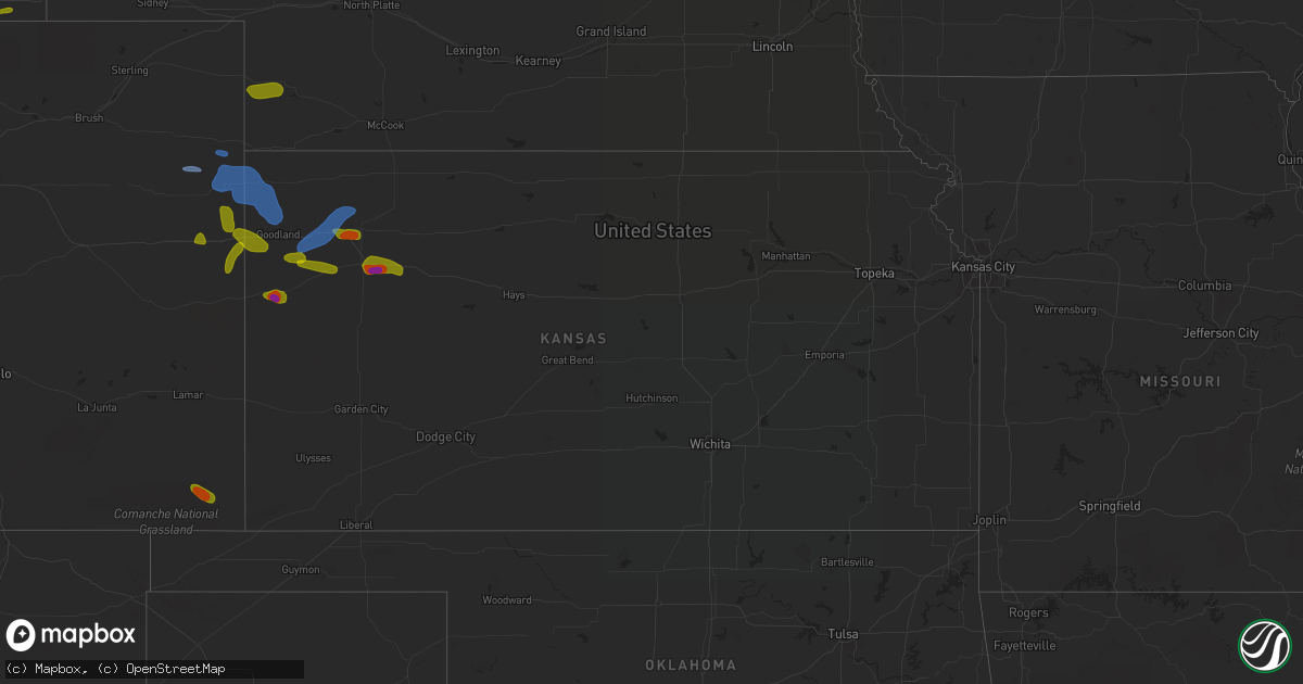
Hail Map in Kansas on August 11, 2020
Get this storm
August 11 map
$229
one time, instant access
Download today. No call, no setup
Keep the $229
Bought the map and want the full workflow? Apply the entire $229 to a subscription within 7 days. None of it is wasted.
Every map, not just this one
This buys you this map. Subscription and you get every map we run, in the markets you choose from a few cities to whole states to nationwide. Plus real-time alerts the moment a storm fires.
Contact data
Name, contact info, occupancy, even credit band for addresses in the footprint. You go from where it hit to who to call.
Become the source they trust
Unlimited branding weather history reports on demand. You already have the documented answer ready for the property owner, and you are the one who showed up with it.
Property data and RoofTrace estimates
Pull up any address you have got, its value and the exact code rules for that jurisdiction, straight from One Click Code. Then RoofTrace estimates the squares, pitch, and roof value, priced the way you price.
Storm reports in Kansas
Kansas
| Date | Description |
|---|---|
| 08/11/202012:40 PM CDT | 1 inch hail reported via twitter at i-70 and k25. |
| 08/11/20203:20 AM CDT | Mesonet site reports a 58mph wind gust. |
| 08/11/20202:49 AM CDT | At 749 PM MDT, a severe thunderstorm was located near Sharon Springs, moving east at 10 mph. HAZARD...60 mph wind gusts and quarter size hail. SOURCE...This storm produced nickel to quarter size hail in Sharon Springs at 746 pm MDT. IMPACT...Hail damage to vehicles is expected. Expect wind damage to roofs, siding, and trees. Locations impacted include... Sharon Springs and Wallace. |
| 08/11/20201:00 AM CDT | Report via facebook of a few tennis ball size hailstones mixed with nickel size hail. |
| 08/11/202012:40 AM CDT | Corrects previous hail report from oakley. Report via facebook of a few tennis ball size hailstones mixed with nickel size hail time based on radar. |
| 08/10/202010:40 PM CDT | At 340 PM MDT/440 PM CDT/, severe thunderstorms were located along a line extending from 12 miles south of Wray to 18 miles west of Bonny Reservoir to 11 miles south of Cope, moving east at 35 mph. HAZARD...60 mph wind gusts. SOURCE...Radar indicated. IMPACT...Expect damage to roofs, siding, and trees. Locations impacted include... St. Francis, Bonny Reservoir, Bird City, Joes, Hale, Beecher Island and Kirk.This includes Highway 385 between mile markers 195 and 236. |
| 08/10/20208:53 PM CDT | Trained spotter observed ongoing ping pong ball sized hail. |
| 08/10/20208:50 PM CDT | Report of estimated golf ball size hail received via social media. |
| 08/10/20208:46 PM CDT | Trained spotter observed nickel to quarter sized hail ongoing. |
All States Impacted by Hail Map on August 11, 2020
Cities Impacted by Hail Map on August 11, 2020
- Marmarth, ND
- Rhame, ND
- Manning, ND
- Dickinson, ND
- Fairfield, ND
- Belfield, ND
- Lisco, NE
- Oshkosh, NE
- Merriman, NE
- Champion, NE
- Imperial, NE
- Lakeside, NE
- Bingham, NE
- Ellsworth, NE
- Ashby, NE
- Cody, NE
- Taylor, NE
- Brewster, NE
- Comstock, NE
- Burwell, NE
- Ord, NE
- Oneill, NE
- Lynch, NE
- Spencer, NE
- Brunswick, NE
- Plainview, NE
- Friona, TX
- Dimmitt, TX
- Levelland, TX
- Wray, CO
- Idalia, CO
- Saint Francis, KS
- Vernon, CO
- Kanorado, KS
- Goodland, KS
- Edson, KS
- Brewster, KS
- Colby, KS
- Levant, KS
- Hope Hull, AL
- Montgomery, AL
- Milesville, SD
- Midland, SD
- Hayes, SD
- Buffalo Gap, SD
- Oral, SD
- Hot Springs, SD
- Custer, SD
- Scenic, SD
- Caputa, SD
- Fairburn, SD
- Hermosa, SD
- Owanka, SD
- New Underwood, SD
- Camp Crook, SD
- Ekalaka, MT
- Prairie City, SD
- Lodgepole, SD
- Reva, SD
- Bison, SD
- Barnard, SD
- Frederick, SD
- Westport, SD
- Yuma, CO
- Eckley, CO
- Plainview, TX
- Hettinger, ND
- Bowman, ND
- Scranton, ND
- Reeder, ND
- Taylor, ND
- Gladstone, ND
- Mott, ND
- New Leipzig, ND
- Hoven, SD
- Eureka, SD
- Java, SD
- Akaska, SD
- Roscoe, SD
- Trail City, SD
- Gettysburg, SD
- Hosmer, SD
- Long Lake, SD
- Glencross, SD
- Mobridge, SD
- Leola, SD
- Mound City, SD
- McLaughlin, SD
- Tolstoy, SD
- Timber Lake, SD
- Selby, SD
- Eagle Butte, SD
- Glenham, SD
- Little Eagle, SD
- Bowdle, SD
- Wakpala, SD
- Aberdeen, SD
- Roslyn, SD
- Stratford, SD
- Claremont, SD
- Langford, SD
- Bath, SD
- Lake City, SD
- Amherst, SD
- Summit, SD
- Grenville, SD
- Ferney, SD
- Bristol, SD
- Eden, SD
- Wilmot, SD
- South Shore, SD
- Pierpont, SD
- Britton, SD
- Groton, SD
- Waubay, SD
- Peever, SD
- Webster, SD
- Veblen, SD
- Ortley, SD
- Conde, SD
- Sisseton, SD
- Columbia, SD
- Andover, SD
- Marvin, SD
- Dawson, MN
- Canby, MN
- Marietta, MN
- Madison, MN
- Carpenter, WY
- Ellaville, GA
- Burlington, CO
- Stratton, CO
- Bethune, CO
- Springfield, CO
- Walsh, CO
- Thedford, NE
- Whitman, NE
- Mullen, NE
- Seneca, NE
- Valentine, NE
- Halsey, NE
- Wallace, KS
- Sharon Springs, KS
- Weskan, KS
- Oakley, KS
- Grinnell, KS
- Hoxie, KS
- Grainfield, KS
- Winona, KS
- Monument, KS
- Hancock, MN
- Dupree, SD
- Haxtun, CO
- Cope, CO
- Quinter, KS
- Ashland, KS
- Faith, SD
- Porter, MN
- Taunton, MN
- Stuart, NE
- Buffalo, SD
- Baker, MT
- Montevideo, MN
- Labolt, SD
- Revillo, SD
- Granite Falls, MN
- Chadron, NE
- Crawford, NE
- Whitney, NE
- Harrison, NE
- Enders, NE
- Vona, CO
- Selden, KS
- Joes, CO
- Caddo, OK
- Meadow, SD
- Lemmon, SD
- Gary, SD
- Parks, NE
- Cheyenne Wells, CO
- Bazine, KS
- Brownell, KS
- Annapolis, MO
- Howes, SD
- Cherry Creek, SD
- Dighton, KS
- Healy, KS
- McIntire, IA
- Wall, SD
- Bellingham, MN
- Maynard, MN
- Le Roy, MN
- Riceville, IA
- Chester, IA
- Bird City, KS
- Gove, KS
- Park, KS
- Holyoke, CO
- Preston, GA
- Stacyville, IA
- Adams, MN
- Taopi, MN
- Letcher, SD
- Otis, CO
- Fleming, CO
- Utica, KS
- Collyer, KS
- Atwood, KS
- Patterson, MO
- Edgemont, SD
- Scotia, NE
- Ericson, NE
- Haigler, NE
- Des Arc, MO
- Sedalia, MO
- Okeechobee, FL
- Atoka, OK
- Wauneta, NE
- Buena Vista, GA
- Bennington, OK
- Arcadia, FL


