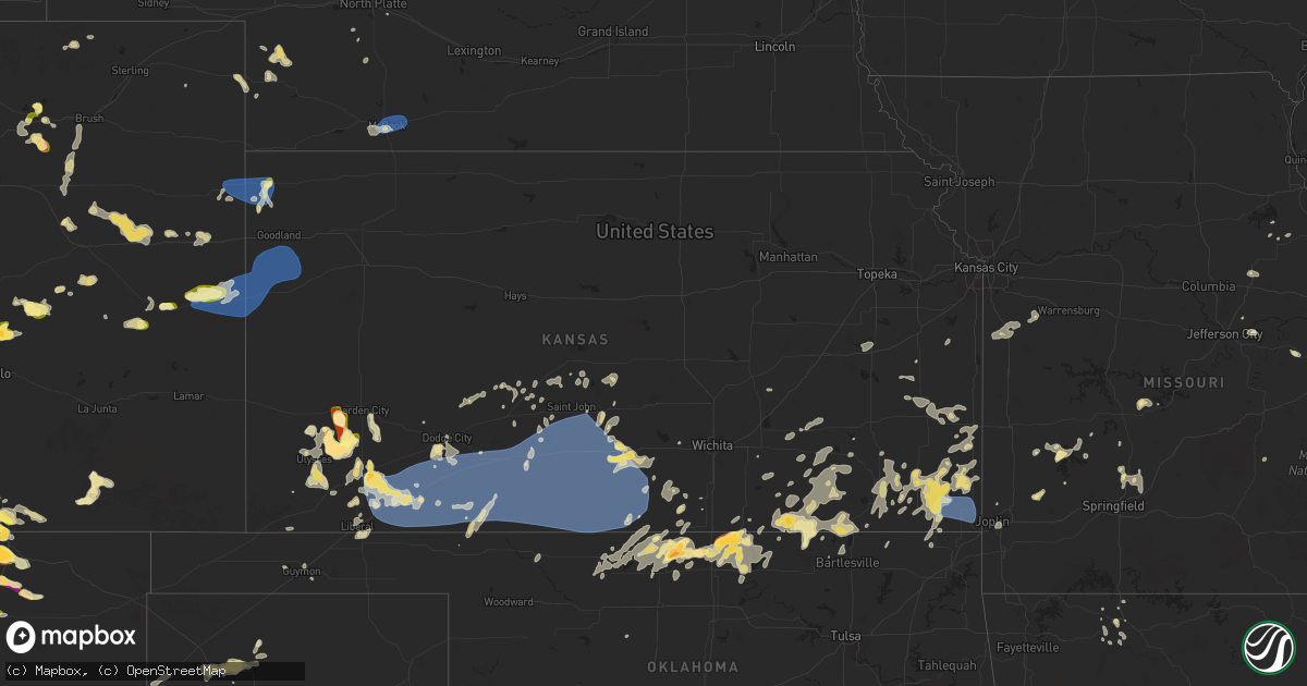
Hail Map in Kansas on August 10, 2025
Get this storm
August 10 map
$229
one time, instant access
Download today. No call, no setup
Keep the $229
Bought the map and want the full workflow? Apply the entire $229 to a subscription within 7 days. None of it is wasted.
Every map, not just this one
This buys you this map. Subscription and you get every map we run, in the markets you choose from a few cities to whole states to nationwide. Plus real-time alerts the moment a storm fires.
Contact data
Name, contact info, occupancy, even credit band for addresses in the footprint. You go from where it hit to who to call.
Become the source they trust
Unlimited branding weather history reports on demand. You already have the documented answer ready for the property owner, and you are the one who showed up with it.
Property data and RoofTrace estimates
Pull up any address you have got, its value and the exact code rules for that jurisdiction, straight from One Click Code. Then RoofTrace estimates the squares, pitch, and roof value, priced the way you price.
Storm reports in Kansas
Kansas
| Date | Description |
|---|---|
| 08/10/20256:22 PM CDT | A local report indicates 1.00 inch wind near 1 NW Elk Falls |
| 08/10/20252:35 AM CDT | Awos station kptt pratt indust. |
| 08/10/20252:24 AM CDT | Pws - pratt county |
| 08/10/20252:24 AM CDT | Pws - pratt county landfill. |
| 08/10/20252:20 AM CDT | Large trees |
| 08/10/20252:18 AM CDT | Pws - kzlf_transmitter_site. |
| 08/10/20252:15 AM CDT | Public report of 80 mph winds and trees down. |
| 08/10/20252:09 AM CDT | Trees were blown down with 80 mph winds. |
| 08/10/20251:58 AM CDT | Mesonet station up323 2.3 e greensburg |
| 08/10/20251:46 AM CDT | A local report indicates 71 MPH wind near 4 SW Greensburg |
| 08/10/20251:44 AM CDT | Pws - kents station. |
| 08/09/202511:55 PM CDT | Site up332 recorded a 67 mph wind gust. |
| 08/09/202511:55 PM CDT | Corrects previous tstm wnd gst report from 5 ese kismet. A public weather station recorded a wind gust of 64 mph. |
| 08/09/202511:49 PM CDT | A public weather station recorded a wind gust of 62 mph. |
| 08/09/202511:46 PM CDT | Site up350 recorded a wind gust of 65 mph. |
| 08/09/202511:36 PM CDT | A local report indicates 65 MPH wind near 4 NE Hayne |
| 08/09/202510:40 PM CDT | A local report indicates 81 MPH wind near 2 ESE Ulysses |
| 08/09/202510:12 PM CDT | Measured 62 mph. |
| 08/09/20258:58 PM CDT | Social media report of nickel to quarter sized hail. |
| 08/09/20258:58 PM CDT | Site kkssaint20 measured 58 mph wind gust. |
| 08/09/20258:45 PM CDT | Pea sized hail also reported. |
All States Impacted by Hail Map on August 10, 2025
Cities Impacted by Hail Map on August 10, 2025
- Harrison, NE
- Alliance, NE
- Harper, IA
- Charles City, IA
- Keota, IA
- Perry, MO
- Laddonia, MO
- Auxvasse, MO
- Mexico, MO
- Vandalia, MO
- Bonnots Mill, MO
- Tebbetts, MO
- New Bloomfield, MO
- Osawatomie, KS
- Paola, KS
- Chamois, MO
- Benedict, KS
- Columbus, KS
- McCune, KS
- Licking, MO
- Salem, MO
- Owensville, MO
- Rosebud, MO
- Green Forest, AR
- Harrison, AR
- Alpena, AR
- Omaha, AR
- Pine, CO
- Compton, AR
- Garrett, WY
- Waldron, AR
- Weston, CO
- Aguilar, CO
- Marble Falls, AR
- Mena, AR
- Walsenburg, CO
- Saint Louis, MO
- Boncarbo, CO
- Beckville, TX
- Rock River, WY
- Trinidad, CO
- Watson, OK
- Denver, CO
- Aurora, CO
- Tatum, TX
- Henderson, TX
- Watkins, CO
- Safford, AZ
- San Carlos, AZ
- Deer Trail, CO
- Agate, CO
- Laramie, WY
- Carr, CO
- Wiggins, CO
- Roggen, CO
- Willcox, AZ
- Raton, NM
- Pueblo, CO
- Yoder, CO
- Fort Morgan, CO
- Limon, CO
- Fountain, CO
- Kersey, CO
- Orchard, CO
- Benson, AZ
- Colorado Springs, CO
- Trinchera, CO
- Uniontown, KS
- Redfield, KS
- Genoa, CO
- Cheyenne, WY
- Macks Creek, MO
- Roach, MO
- Weldona, CO
- Rush, CO
- Stockton, MO
- Ramah, CO
- Climax Springs, MO
- Fair Play, MO
- Cross Timbers, MO
- Arcola, MO
- Fredonia, KS
- Fall River, KS
- Moline, KS
- Dadeville, MO
- Longton, KS
- Portales, NM
- Cedar Vale, KS
- Rogers, NM
- Hepler, KS
- Jerico Springs, MO
- Arriba, CO
- Howard, KS
- Elk Falls, KS
- Fort Scott, KS
- Lamar, MO
- Sudan, TX
- Hugo, CO
- Edinburg, TX
- Kim, CO
- Branson, CO
- Sheldon, MO
- Dunnegan, MO
- Petersburg, IL
- Sedan, KS
- Flagler, CO
- Mapleton, KS
- Morton, TX
- Cimarron, NM
- Muleshoe, TX
- Maxwell, NM
- Fulton, KS
- Elk City, KS
- Oakford, IL
- Easton, IL
- Humansville, MO
- Flemington, MO
- Patagonia, AZ
- Vona, CO
- Mason City, IL
- Seibert, CO
- Joplin, MO
- Piedmont, KS
- Great Lakes, IL
- Lake Bluff, IL
- Polk, MO
- Pittsburg, MO
- Dexter, KS
- Cambridge, KS
- San Jose, IL
- Springer, NM
- Grenola, KS
- Farlington, KS
- Silverton, TX
- Grover, CO
- Archie, MO
- Drexel, MO
- Lake Forest, IL
- Nunn, CO
- Miami, NM
- Karval, CO
- Saint Paul, KS
- Strafford, MO
- Half Way, MO
- Harrisonville, MO
- Freeman, MO
- Fair Grove, MO
- Arcadia, KS
- Hermitage, MO
- Girard, KS
- Haswell, CO
- Pleasant Hope, MO
- Longmont, CO
- Pierce, CO
- Buffalo, MO
- Stratton, CO
- Bethune, CO
- Cherokee, KS
- Marshfield, MO
- Shreveport, LA
- Kit Carson, CO
- Imperial, NE
- Burlington, CO
- Elkland, MO
- Westphalia, KS
- Boulder, CO
- Grant, NE
- Haxtun, CO
- Pittsburg, KS
- Shidler, OK
- Walnut, KS
- Weir, KS
- Havana, KS
- Peru, KS
- Louisburg, MO
- Lafayette, CO
- Champion, NE
- Holyoke, CO
- New Raymer, CO
- Niotaze, KS
- Garnett, KS
- Braman, OK
- Blackwell, OK
- Potter, NE
- Scammon, KS
- Chautauqua, KS
- Newkirk, OK
- Erie, CO
- Maple City, KS
- Richmond, KS
- Idalia, CO
- Stoneham, CO
- Goodland, KS
- Berthoud, CO
- Welda, KS
- Oronogo, MO
- Pawhuska, OK
- Cheyenne Wells, CO
- Kirk, CO
- Saint Francis, KS
- Wray, CO
- Venango, NE
- Bridgeport, NE
- Bayard, NE
- Galesburg, KS
- Caney, KS
- Copeland, KS
- Satanta, KS
- Ulysses, KS
- Franklin, KS
- Arma, KS
- Frontenac, KS
- Medford, OK
- Kanorado, KS
- Arapahoe, CO
- Garden City, KS
- Colony, KS
- Pierceville, KS
- Mound Valley, KS
- Coffeyville, KS
- Erie, KS
- Parsons, KS
- Lamont, OK
- Mulberry, KS
- Ponca City, OK
- Deer Creek, OK
- Arkansas City, KS
- Geuda Springs, KS
- Sarcoxie, MO
- Reeds, MO
- Golden City, MO
- Nardin, OK
- Holcomb, KS
- Lakin, KS
- Weskan, KS
- La Harpe, KS
- Kincaid, KS
- Altamont, KS
- Lockwood, MO
- Greenfield, MO
- Everton, MO
- Deerfield, KS
- Sharon Springs, KS
- Wallace, KS
- Moran, KS
- Oswego, KS
- Burden, KS
- Kaw City, OK
- Calhan, CO
- Nash, OK
- Pond Creek, OK
- Blue Mound, KS
- Sublette, KS
- Bronson, KS
- Atlanta, KS
- Rock, KS
- Chetopa, KS
- Welch, OK
- Edson, KS
- Holden, MO
- Garden City, MO
- Galena, KS
- Riverton, KS
- Baxter Springs, KS
- Kingsville, MO
- Jet, OK
- Wakita, OK
- Rolla, KS
- Richfield, KS
- Texline, TX
- Lebo, KS
- Hugoton, KS
- Moscow, KS
- Manchester, OK
- Marland, OK
- Cunningham, KS
- Carmen, OK
- Argonia, KS
- Dodge City, KS
- Liberal, KS
- Wild Horse, CO
- Osage City, KS
- Culbertson, NE
- McCook, NE
- Kismet, KS
- Caldwell, KS
- Severy, KS
- Dalhart, TX
- Cherokee, OK
- Kingman, KS
- Milton, KS
- Plains, KS
- Hartley, TX
- Tonkawa, OK
- Channing, TX
- Eureka, KS
- Turpin, OK
- Wellington, KS
- Mayfield, KS
- Fowler, KS
- Dumas, TX
- Garden Plain, KS
- Burlington, OK
- Amorita, OK
- Hanston, KS
- Indianola, NE
- Meade, KS
- Burns, KS
- Rosston, OK
- Burdett, KS
- Sunray, TX
- Larned, KS
- Augusta, KS
- Maywood, NE
- Hayes Center, NE
- La Russell, MO
- Anthony, KS
- Englewood, KS
- Minneola, KS
- Stratford, TX
- Jetmore, KS
- Ashland, KS
- Milan, KS
- Buffalo, OK
- Wellfleet, NE
- Cimarron, KS
- Dickens, NE
- Bartlesville, OK
- Waldron, KS
- Copan, OK
- Rozel, KS
- Pawnee Rock, KS
- North Platte, NE
- Conway Springs, KS
- St John, KS
- Zenda, KS
- Great Bend, KS
- Hudson, KS
- Protection, KS
- Murdock, KS
- Goodwell, OK
- Spivey, KS
- Garfield, KS
- Haviland, KS
- Dacoma, OK
- Sterling, KS
- Alden, KS
- Ellinwood, KS
- Kinsley, KS
- Guymon, OK
- Raymond, KS
- Ford, KS
- Harper, KS
- Coldwater, KS
- Bucklin, KS
- Mullinville, KS
- Wilmore, KS
- Turon, KS
- Belpre, KS
- Edna, KS
- Lake City, KS
- Sun City, KS
- Lenapah, OK
- Macksville, KS
- Stafford, KS
- Greensburg, KS
- Coats, KS
- Pratt, KS
- Montezuma, KS
- Ensign, KS
- Mooreland, OK
- Plevna, KS
- Norwich, KS
- Sylvia, KS
- Lewis, KS
- Byers, KS
- Medicine Lodge, KS
- Sawyer, KS
- Hardtner, KS
- Alva, OK
- Arlington, KS
- Danville, KS
- Freedom, OK
- Bartlett, KS
- Hazelton, KS
- Kiowa, KS
- Sharon, KS
- Isabel, KS
- Iuka, KS
- Attica, KS
- Nashville, KS
- Liberty, KS
- Independence, KS
- Cherryvale, KS
- Neodesha, KS
- Okeene, OK
- Dennis, KS
- Leon, KS
- Thayer, KS
- Altoona, KS
- Toronto, KS
- Maxwell, NE
- Chanute, KS


