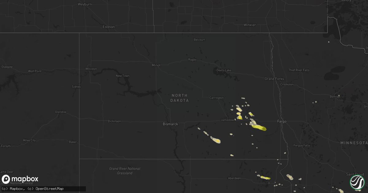
Hail Map in North Dakota on August 9, 2017
Get this storm
August 9 map
$229
one time, instant access
Download today. No call, no setup
Keep the $229
Bought the map and want the full workflow? Apply the entire $229 to a subscription within 7 days. None of it is wasted.
Every map, not just this one
This buys you this map. Subscription and you get every map we run, in the markets you choose from a few cities to whole states to nationwide. Plus real-time alerts the moment a storm fires.
Contact data
Name, contact info, occupancy, even credit band for addresses in the footprint. You go from where it hit to who to call.
Become the source they trust
Unlimited branding weather history reports on demand. You already have the documented answer ready for the property owner, and you are the one who showed up with it.
Property data and RoofTrace estimates
Pull up any address you have got, its value and the exact code rules for that jurisdiction, straight from One Click Code. Then RoofTrace estimates the squares, pitch, and roof value, priced the way you price.
Storm reports in North Dakota
North Dakota
| Date | Description |
|---|---|
| 08/09/20175:19 PM CDT | A few large hail near hwy 46 and cr18. Shelf cloud earlier but wind not too bad. |
| 08/09/20174:45 PM CDT | Very heavy rain and strong winds along with hail nearly covering the ground across central clifton township. A few of the largest hail were nickel to quarter sized. Mos |
| 08/09/20174:43 PM CDT | Very heavy rain and strong winds along with hail nearly covering the ground across central clifton township. A few of the largest hail were nickel to quarter sized. Mos |
| 08/09/20173:25 PM CDT | A few nickel to quarter sized hail in heavy rains across northern noltimier township. |
| 08/09/20172:55 PM CDT | Large hail didnt cover the ground but a few were quarter sized or a bit bigger. |
All States Impacted by Hail Map on August 9, 2017
Cities Impacted by Hail Map on August 9, 2017
- Kim, CO
- Pritchett, CO
- Jasper, MN
- Trenary, MI
- Hays, KS
- Ellis, KS
- Plainville, KS
- Waubay, SD
- Grenville, SD
- Valley City, ND
- Trementina, NM
- Otis, KS
- Bison, KS
- Attica, KS
- Branson, CO
- Trinidad, CO
- Albert, KS
- Newcastle, WY
- Stewart, MN
- Buffalo Lake, MN
- St John, KS
- Little Rock, IA
- Medicine Lodge, KS
- Turon, KS
- Zenda, KS
- Nashville, KS
- Lance Creek, WY
- Wetmore, MI
- Munising, MI
- Nara Visa, NM
- Beaver City, NE
- Hendley, NE
- Springer, NM
- Susanville, CA
- Watertown, SD
- Florence, SD
- Fingal, ND
- Fort Bridger, WY
- Roosevelt, MN
- Colorado Springs, CO
- Las Vegas, NM
- Burlington, OK
- Hazelton, KS
- Kiowa, KS
- Cherokee, OK
- Fredonia, ND
- Rapid River, MI
- Grenville, NM
- Holland, MN
- Ellinwood, KS
- Olmitz, KS
- Great Bend, KS
- Hoisington, KS
- Brooker, FL
- Cimarron, NM
- May, OK
- Laverne, OK
- Oriska, ND
- Russell, KS
- Wagon Mound, NM
- Miami, NM
- Sedan, NM
- Texline, TX
- Dalhart, TX
- Clayton, NM
- Brookings, SD
- Rockland, ID
- Pueblo, CO
- Penrose, CO
- Canon City, CO
- Florence, CO
- Avondale, CO
- Clinton, MN
- Hartington, NE
- Laurel, NE
- Coleridge, NE
- Twin Brooks, SD
- Marvin, SD
- Cunningham, KS
- Boyd, MN
- Clarkfield, MN
- Minneota, MN
- Roslyn, SD
- Webster, SD
- Gorham, KS
- Grove City, MN
- Mason City, NE
- Pleasanton, NE
- Litchfield, NE
- Hazard, NE
- Bemidji, MN
- Clancy, MT
- Fort Supply, OK
- Rock, MI
- Logan, KS
- Norton, KS
- Bogue, KS
- Prairie View, KS
- Lenora, KS
- Almena, KS
- Gackle, ND
- Kulm, ND
- Dickey, ND
- Sanborn, ND
- Rogers, ND
- Wimbledon, ND
- Spiritwood, ND
- Farnam, NE
- Elwood, NE
- Eustis, NE
- Harper, KS
- Doyle, CA
- Medford, OK
- Manchester, OK
- Dazey, ND
- Keyes, OK
- Costilla, NM
- Maple Lake, MN
- Buffalo, MN
- Waverly, MN
- Annandale, MN
- Howard Lake, MN
- Reno, NV
- Lake Butler, FL
- Edgerton, MN
- Pipestone, MN
- Montevideo, MN
- Elkton, SD
- Graceville, MN
- Sisseton, SD
- Gladstone, NM
- Des Moines, NM
- Bell, FL
- Roy, NM
- Mosquero, NM
- Claflin, KS
- Lindstrom, MN
- Ruthton, MN
- Woodstock, MN
- Wood Lake, MN
- Echo, MN
- Old Station, CA
- Pawnee Rock, KS
- Fowler, CO
- Bellingham, MN
- Palco, KS
- Alachua, FL
- Mahnomen, MN
- Fountain, CO
- Cooperstown, ND
- Coats, KS
- Sun City, KS
- Garita, NM
- Conchas Dam, NM
- Manly, IA
- Kensett, IA
- Rosston, OK
- Arnett, OK
- Leedey, OK
- Stafford, KS
- Gibbon, MN
- Ellendale, ND
- Baton Rouge, LA
- Montello, NV
- Streeter, ND
- Napoleon, ND
- Burney, CA
- Kingman, KS
- Trent, SD
- Sapello, NM
- Skandia, MI
- Enderlin, ND
- Wakita, OK
- Hanley Falls, MN
- Hector, MN
- Anthony, KS
- Bluff City, KS
- Big Bar, CA
- White, SD
- Toronto, SD
- Ravenna, NE
- Gibbon, NE
- Green Cove Springs, FL
- Larkspur, CO
- Calhan, CO
- Elbert, CO
- Peyton, CO
- Florissant, CO
- Dawson, ND
- Sibley, IA
- Adrian, MN
- Hardwick, MN
- Kenneth, MN
- Montpelier, ND
- Luverne, MN
- Litchville, ND
- Lake Wilson, MN
- Spivey, KS
- Litchfield, MN
- Pierpont, SD
- Winnfield, LA
- Flandreau, SD
- Hazel, SD
- Spicer, MN
- Doerun, GA
- Hannaford, ND
- Luverne, ND
- Saint Peter, MN
- Le Sueur, MN
- Carson City, NV
- Mad River, CA
- Egan, SD
- Lake Benton, MN
- Chatham, MI
- Summit, SD
- Fort Ransom, ND
- Lisbon, ND
- Amorita, OK
- Sharon, KS
- Sawyer, KS
- Fairmount, ND
- Northwood, IA
- Stirum, ND
- Canby, MN
- Bruce, SD
- Courtenay, ND
- Ellsworth, MN
- Tyler, MN
- Grafton, IA
- Osage, IA
- Jamestown, ND
- Brownton, MN
- Odessa, MN
- Castlewood, SD
- Cottage Grove, MN
- Lake City, KS
- Naytahwaush, MN
- Preston, ID
- Guffey, CO
- New Effington, SD
- Granite Falls, MN
- Raton, NM
- Corona, NM
- Tower City, ND
- Dawson, MN
- Inglis, FL
- Whitehall, MT
- Gardnerville, NV
- Atwater, MN
- Sacred Heart, MN
- Gwinner, ND
- Homosassa, FL
- Model, CO
- Garretson, SD
- Gainesville, FL
- Sale City, GA
- Rushmore, MN
- Spring Hill, FL
- Hudson, FL
- Appleton, MN
- Holbrook, NE
- Arapahoe, NE
- Chokio, MN
- Morris, MN
- Vesta, MN
- Roosevelt, UT
- Estelline, SD
- Fairfax, MN
- Verdi, NV
- Nogales, AZ
- Langford, SD
- Cokato, MN
- Tulelake, CA
- Peever, SD
- Leonard, ND


