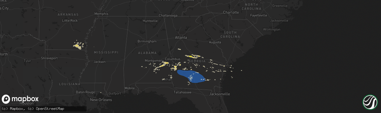
Hail Map on August 8, 2023
The weather event on August 8, 2023 includes Hail, Wind, and Tornado maps. 19 states and 553 cities were impacted and suffered possible damage. The total estimated number of properties impacted is 38,279.
Want more than just the map?
Turn this storm into a full workflow.
- Owner + property data so you know who to knock
- OnDemand branded weather history reports to win the "did we even have hail?" argument
- RoofTrace estimate so reps stop guessing numbers at the door
Bought this map? Upgrade within 7 days and we'll credit the $230. (10-15 min setup call)
Hail
Wind
Tornado
38,279
Estimated number of impacted properties by a 1.00" hail or larger7,030
Estimated number of impacted properties by a 1.75" hail or larger5,519
Estimated number of impacted properties by a 2.50" hail or largerStates Impacted by Hail Map on August 8, 2023
Storm reports
Massachusetts
| Date | Description |
|---|---|
| 08/08/20233:05 PM CDT | A small ef-1 tornado touched down in the town of mattapoisett massachusetts at 11:20 am edt. The storm was on the ground for approximately 3 minutes. The storm moved to |
| 08/08/202311:51 AM CDT | Numerous trees down in the tinkham lane area as well as on acushnet road and stoney hill road. |
| 08/08/202311:15 AM CDT | Tree down along rt 6 near exit 68. Relayed by amateur radio. |
| 08/08/202311:05 AM CDT | Several reports of trees and wires down and trees blocking the road on west barnstable road in osterville and on commerce road at main street. |
| 08/08/202310:52 AM CDT | A small ef-0 tornado touched down in the town of barnstable... Near the village of marstons mills... At 11:52 am. The storm tracked ene from evergreen drive for approxi |
| 08/08/202310:20 AM CDT | Trees down on acushent rd. Relayed by amateur radio. |
| 08/08/202310:20 AM CDT | Trees and wires down on north street around eldorado dr. Relayed by amateur radio. |
| 08/08/202310:20 AM CDT | Corrects previous tornado report from 2 wnw mattapoisett. A small ef-1 tornado touched down in the town of mattapoisett massachusetts at 11:20 am edt. The storm was on |
| 08/08/202310:20 AM CDT | Trees and wires down on hereford hill rd. Relayed by amateur radio. |
| 08/08/20239:25 AM CDT | Large tree and wires down on ashland street. |
South Dakota
| Date | Description |
|---|---|
| 08/08/20235:36 PM CDT | Mostly smaller. Time is when the largest hail was falling. |
| 08/08/20235:36 PM CDT | Mostly smaller. Time is when the largest hail was falling. |
Minnesota
| Date | Description |
|---|---|
| 08/08/20235:58 PM CDT | Spotter reports that a tree 12 to 14 inches in diameter was blown over. This tree then fell on a couple of power poles and broke them. Time of wind damage estimated fro |
| 08/08/20235:15 PM CDT | Corrects previous hail report from hawley. Picture relayed by broadcast media. Time estimated from radar. |
| 08/08/20235:08 PM CDT | Picture relayed by broadcast media. Time estimated from radar. |
| 08/08/20233:40 PM CDT | Delayed report: city office reports ping pong sized hail. |
| 08/08/20233:10 PM CDT | Pea to quarter size hail. Time estimated from radar. |
| 08/08/20232:55 PM CDT | Mostly dime size hail with a few hailstones around quarter size. Time approximate. Storm started around two thirty pm and was ending around time of phone call around th |
| 08/08/20238:10 AM CDT | Delayed report: 10 inch healthy tree blown down... Time estimated from radar. |
| 08/07/20238:10 PM CDT | Delayed report: tree damage to grove... Time estimated from radar. |
| 08/07/20238:10 PM CDT | Corrects previous tstm wnd dmg report from rothsay. Delayed report: 10 inch healthy tree blown down... Time estimated from radar. |
Kansas
| Date | Description |
|---|---|
| 08/08/20233:10 AM CDT | Personal weather station. |
| 08/08/20232:29 AM CDT | Personal weather station... Via wunderground... Station kksalexa8. |
| 08/08/20232:21 AM CDT | A local report indicates 1.00 inch wind near Hoisington |
| 08/08/20232:15 AM CDT | Delayed report of isolated damage on a farmstead including part of an outbuilding roof blown off and a bulk bin blown over. Time estimated from radar data. |
| 08/07/202310:21 PM CDT | Tornado debris signature |
| 08/07/202310:21 PM CDT | Possible tornado damage to an abandoned structure along with downed powerlines east of county rd 3 on county rd 61. Timing estimated via radar. |
| 08/07/202310:13 PM CDT | Estimated time of report. The size is estimated from divots in the ground. |
West Virginia
| Date | Description |
|---|---|
| 08/08/20233:35 PM CDT | Downed tree reported in gassaway. Photo accompanied social media report. |
Oklahoma
| Date | Description |
|---|---|
| 08/08/20231:45 AM CDT | Power poles down. Pictures on slack. Time estimated from radar. |
| 08/08/202312:45 AM CDT | Hobart |
| 08/08/202312:40 AM CDT | Hobart |
| 08/08/202312:25 AM CDT | Elk city |
Texas
| Date | Description |
|---|---|
| 08/07/202310:49 PM CDT | Peak wind gust measured by the west texas mesonet. A few additonal severe wind gusts occurred between 1040 pm and 1051 pm. |
| 08/07/202310:40 PM CDT | Measured by the west texas mesonet. |
| 08/07/202310:34 PM CDT | A local report indicates 58 MPH wind near 1 ENE Mclean |
| 08/07/202310:21 PM CDT | Peak gust measured by the west texas mesonet. The site measured several gusts in excess of 58 mph between 1019 pm and 1034 pm. |
| 08/07/202310:20 PM CDT | Measured by the west texas mesonet |
| 08/07/20238:20 PM CDT | Peak wind gust of 68 mph measured by mesonet at 8:20 pm... Followed by a 58 mph gust at 8:21 pm... Then dropped below severe levels. |
Georgia
| Date | Description |
|---|---|
| 08/08/20236:58 PM CDT | Tree reported down on ferguson avenue at marvalingrove dr. Time estimated from radar. |
| 08/08/20236:58 PM CDT | One tree reported down in midway... Ga. Time estimated from radar. |
| 08/08/20236:57 PM CDT | Tree reported down on northgate rd. Time estimated from radar. |
| 08/08/20236:55 PM CDT | Tree reported down on harlan dr. Time estimated from radar. |
| 08/08/20236:50 PM CDT | Tree reported down on grove point road. Time estimated from radar. |
| 08/08/20236:50 PM CDT | A total of 7 different reports of trees down in atkinson county. Most notable areas were near sunnyside church rd and tr hattaway rd areas. Time estimated from radar. |
| 08/08/20236:49 PM CDT | The university of georgia mesonet site at the zblu berry farm south of us highway 82 and west of us highway 301 reported this gust. |
| 08/08/20236:46 PM CDT | Multiple trees reported down in stilson... Ga. Time estimated from radar. |
| 08/08/20236:46 PM CDT | Tree down on old louisville road. Time estimated from radar. |
| 08/08/20236:46 PM CDT | Tree reported down on augusta road at crossgate road. Time estimated from radar. |
| 08/08/20236:46 PM CDT | Multiple trees down reported in brooklet... Ga. Time estimated from radar. |
| 08/08/20236:46 PM CDT | Multiple trees reported down in arcola... Ga. Time estimated from radar. |
| 08/08/20236:45 PM CDT | Trees and powerlines down along high bluff road. Report received via social media. Time was estimated by radar. |
| 08/08/20236:44 PM CDT | Tree reported down on salt creek road. Time estimated from radar. |
| 08/08/20236:42 PM CDT | Tree reported down on 600 block of railroad avenue in daisy... Ga. Time estimated from radar. |
| 08/08/20236:41 PM CDT | Tree reported down on abercorn street at gateway blvd. Time estimated from radar. |
| 08/08/20236:41 PM CDT | Multiple trees down reported in daisy... Ga. |
| 08/08/20236:40 PM CDT | One tree uprooted on chevis road. Time estimated from radar. |
| 08/08/20236:38 PM CDT | One tree reported down in hinesville... Ga. Time estimated from radar. |
| 08/08/20236:35 PM CDT | Multiple trees reported down across claxton... Ga. Time estimated from radar. |
| 08/08/20236:33 PM CDT | A metal street sign was blown over at the intersection of peterson ave and ward street. Time was estimated by radar. |
| 08/08/20236:32 PM CDT | Multiple trees down reported in register... Ga. Time estimated from radar. |
| 08/08/20236:30 PM CDT | Tree down on billy rd. Time estimated from radar. |
| 08/08/20236:30 PM CDT | Candler county sheriff's office reported trees and powerlines down near excelsior including on excelsior road and dutch fork road. |
| 08/08/20236:29 PM CDT | Metter fire department chief reported multiple trees down across the town of metter. |
| 08/08/20236:28 PM CDT | 911 call center reported power line down at the intersection of porterfield and indian trail rd. Time was estimated via radar data. |
| 08/08/20236:25 PM CDT | Metter airport gusted to 56 kts |
| 08/08/20236:22 PM CDT | Multiple trees reported down in bellville... Ga. Time estimated from radar. |
| 08/08/20236:22 PM CDT | Candler county sheriff's office reported trees and powerlines down in several locations including on macwac lake road... Holland road... And freedom lane. |
| 08/08/20236:20 PM CDT | Tree down on mershon rd. Time estimated from radar. |
| 08/08/20236:16 PM CDT | A 911 call center reported a power line down across the railroad track near the 3300 block of hwy 280 w. Time was estimated via radar data. |
| 08/08/20236:15 PM CDT | 3 separate reports of trees down across roads in madray springs. Time estimated from radar. |
| 08/08/20236:15 PM CDT | Asos station kamg alma. |
| 08/08/20236:15 PM CDT | Tree on house. |
| 08/08/20236:14 PM CDT | Candler county sheriff's office reported a tree down on powerlines near the intersection of griffin ferry road and 46 west. |
| 08/08/20236:13 PM CDT | Multiple trees reported down in collins... Ga. Time estimated from radar. |
| 08/08/20236:13 PM CDT | Multiple trees reported down in reidsville... Ga. Time estimated from radar. |
| 08/08/20236:13 PM CDT | Multiple trees down in cobbtown... Ga. |
| 08/08/20236:13 PM CDT | A 911 call center reported a tree down across the roadway near the 4900 block of hwy 280 w. Time was estimated via radar data. |
| 08/08/20236:13 PM CDT | A 911 call center reported a tree down across the roadway near the 4900 block of hwy 280 w. Time was estimated via radar data. |
| 08/08/20236:13 PM CDT | A 911 call center reported two trees and a power line down along hwy 280... Located near the cross streets of harvey rd as well as groveland nevils rd. Time was estimed |
| 08/08/20236:10 PM CDT | Trees down. |
| 08/08/20236:10 PM CDT | Trees down. |
| 08/08/20236:05 PM CDT | Numerous trees and power lines were blown down across the county. |
| 08/08/20236:05 PM CDT | Trees down. |
| 08/08/20236:02 PM CDT | Tree limbs and trees down near pearson. Radar estimated time. |
| 08/08/20235:50 PM CDT | A tree was blown down onto a power line at 5100 fiveash road. |
| 08/08/20235:50 PM CDT | Multiple reports of structural damage on the nw side of mt. Vernon along mckinnon street. |
| 08/08/20235:45 PM CDT | Numerous trees down on the west side of berrien county. Storms still moving across eastern half of the county. |
| 08/08/20235:45 PM CDT | A tree was blown down onto a power line near coppage road and skipper bridge road. |
| 08/08/20235:44 PM CDT | One tree reported down on hwy 144 and 178. Time estimated from radar. |
| 08/08/20235:42 PM CDT | Tree down on mccranie road in sparks. |
| 08/08/20235:40 PM CDT | Powerlines down. |
| 08/08/20235:40 PM CDT | Power pole down in pavo. |
| 08/08/20235:35 PM CDT | Trees were reported down all across coffee county. Time was estimated by radar. More specific locations will be provided later. |
| 08/08/20235:35 PM CDT | Trees were reported down all across coffee county. Time was estimated by radar. More specific locations will be provided later. |
| 08/08/20235:35 PM CDT | Tree down. |
| 08/08/20235:33 PM CDT | Tree down in coolidge. Time estimated by radar. |
| 08/08/20235:32 PM CDT | One tree reported down on oak road and church road. Time estimated from radar. |
| 08/08/20235:30 PM CDT | Tree down. |
| 08/08/20235:30 PM CDT | Tree down. |
| 08/08/20235:30 PM CDT | Tree down. |
| 08/08/20235:29 PM CDT | One tree down reported on hwy 292 and jack anderson rd. |
| 08/08/20235:26 PM CDT | A tree was reported down on a powerline along hwy 117. |
| 08/08/20235:25 PM CDT | Several trees down across the county. |
| 08/08/20235:25 PM CDT | Powerlines down. |
| 08/08/20235:25 PM CDT | Powerline down. |
| 08/08/20235:24 PM CDT | Tree down. |
| 08/08/20235:24 PM CDT | Tree down. |
| 08/08/20235:24 PM CDT | Tree down. |
| 08/08/20235:24 PM CDT | Tree down. |
| 08/08/20235:22 PM CDT | Tree down. |
| 08/08/20235:22 PM CDT | Large tree branches around 5 inches in diameter and one small tree were blown down. |
| 08/08/20235:20 PM CDT | Tree down. |
| 08/08/20235:20 PM CDT | Tree down. |
| 08/08/20235:20 PM CDT | Numerous trees down countywide. |
| 08/08/20235:17 PM CDT | Tree down. |
| 08/08/20235:15 PM CDT | A pecan tree and power lines were blown down on west roanoke drive. |
| 08/08/20235:15 PM CDT | Tree down. |
| 08/08/20235:15 PM CDT | Powerlines down. |
| 08/08/20235:12 PM CDT | Trees were blown down along walker ave on the west side of fitzgerald. |
| 08/08/20235:11 PM CDT | Trained spotter measured 60 mph gust on roof top anemometer. |
| 08/08/20235:08 PM CDT | Trees down on mount olive church road. One tree fell on a school bus. No injuries. |
| 08/08/20235:00 PM CDT | Numerous trees down countywide. |
| 08/08/20234:59 PM CDT | Handheld anemometer measured 70 mph gust. |
| 08/08/20234:54 PM CDT | 20 plus trees down and powerlines. |
| 08/08/20234:52 PM CDT | Tree down on 91 south in baker county. Time estimated by radar. |
| 08/08/20234:52 PM CDT | Trees and powerlines down on east crawford in colquitt. |
| 08/08/20234:50 PM CDT | Tree down along royal crest circle. |
| 08/08/20234:50 PM CDT | Tree down. |
| 08/08/20234:50 PM CDT | Numerous trees down countywide. |
| 08/08/20234:50 PM CDT | Numerous trees down countywide. |
| 08/08/20234:50 PM CDT | Tree and powerlines downed along raven ave. |
| 08/08/20234:50 PM CDT | Trees were blown down at oglethorpe boulevard/liberty expressway. |
| 08/08/20234:46 PM CDT | Tree and powerlines downed along lake placid dr. |
| 08/08/20234:45 PM CDT | Tree down. |
| 08/08/20234:45 PM CDT | Tree and powerline down on a car near the intersection of sandy run rd and s. Hwy 247. |
| 08/08/20234:45 PM CDT | Trees were blown down at the 1400 block of 11th avenue. |
| 08/08/20234:42 PM CDT | Tree down along garden ct. |
| 08/08/20234:41 PM CDT | Tree down on a house along lakeshore dr. |
| 08/08/20234:40 PM CDT | Tree down along bigham dr. |
| 08/08/20234:40 PM CDT | Tree down on a house along welney circle. |
| 08/08/20234:40 PM CDT | Trees were blown down at nottingham way/whispering pines road. |
| 08/08/20234:40 PM CDT | Tree down along rolling woods circle. |
| 08/08/20234:40 PM CDT | Tree down at the intersection of sonja dr and belmont dr. |
| 08/08/20234:39 PM CDT | Numerous trees down countywide. |
| 08/08/20234:35 PM CDT | Trees were blown down at old dawson road/winifred road. |
| 08/08/20234:35 PM CDT | Trees down. |
| 08/08/20234:35 PM CDT | Tree down along steeplechase run. |
| 08/08/20234:35 PM CDT | Trees down. |
| 08/08/20234:35 PM CDT | Trees knocked down destroying a wooden fence. |
| 08/08/20234:30 PM CDT | Tree and powerlines down. |
| 08/08/20234:30 PM CDT | 1.00 hail reported near the intersection of gunn rd and us hwy 41. |
| 08/08/20234:27 PM CDT | A local report indicates 1.00 inch wind near Byron |
| 08/08/20234:20 PM CDT | A couple trees down around leesburg. Stop light blown from overhanging wire and impacted car. Other stop light is still hanging from partially-downed wire. |
| 08/08/20234:00 PM CDT | Numerous trees down countywide. |
| 08/08/20234:00 PM CDT | Trees and powerlines reported down throughout ellaville including: 57th block of n. Stevens st. 465th block of n broad st. 39th block of bridges st. |
| 08/08/20233:45 PM CDT | Numerous trees down across the county. |
| 08/08/20233:45 PM CDT | Multiple trees were reported down across webster county including a number of roads that were impassable... All north of hwy 280. |
| 08/08/20233:45 PM CDT | A tree fell onto a power line on murray farm rd and caused a fire in a wooded area. |
| 08/08/20233:40 PM CDT | A tree fell onto power lines on school ave at 2nd st. |
| 08/08/20233:25 PM CDT | Tree downed along whitfield road. |
| 08/08/20233:25 PM CDT | Tree down at the intersection of scott rd and hwy 26. |
| 08/08/20233:25 PM CDT | 2 trees down on winding way road. Time estimated by radar. |
| 08/08/20233:20 PM CDT | Tree blocking both lanes of thompson rd. |
| 08/08/20233:19 PM CDT | A tree was reported down across thompson rd. |
| 08/08/20233:19 PM CDT | A tree was reported down across thompson rd. |
| 08/08/20239:07 AM CDT | Tree down. |
| 08/07/20237:42 PM CDT | Delayed report and time estimated by radar. A tree was reported down at sasser point on st simons island. |
| 08/07/20237:34 PM CDT | Delayed report and time estimated by radar. A tree down on magnolia avenue in brunswick ga. |
| 08/07/20237:34 PM CDT | Delayed report and time estimated by radar. Tree reported down on bartow st in brunswick ga. |
| 08/07/20237:14 PM CDT | Tybee south weather flow |
| 08/07/20237:09 PM CDT | One tree reported down on belle bluff road. Time estimated from radar. |
| 08/07/20237:05 PM CDT | *** 1 fatal *** chatham county police department and chatham county emergency management agency reported one fatality due to a tree falling on a vehicle in the 5600 blo |
| 08/07/20237:05 PM CDT | *** 1 fatal *** chatham county police department and chatham county emergency management agency reported one fatality due to a tree falling on a vehicle in the 5600 blo |
South Carolina
| Date | Description |
|---|---|
| 08/08/20238:26 AM CDT | Recorded by kmyr awos |
| 08/08/20238:26 AM CDT | Recorded by kmyr awos |
| 08/07/20239:03 PM CDT | Emergency manager reported a tree down along 3500 bonnie doon rd. Time was estimated via radar data. |
| 08/07/20238:03 PM CDT | A 911 call center reported a tree down along new riverside rd. Time was estimated via radar data. |
| 08/07/20237:41 PM CDT | Jasper county dispatch reported a tree down in the 1500 block of grays highway near the ridgeland airport due to thunderstorm outflow. |
| 08/07/20237:41 PM CDT | A 911 call center reported a tree down along waterford dr. Time was estimated via radar data. |
| 08/07/20237:39 PM CDT | Tree down reported on great swamp road. Time estimated from radar. |
| 08/07/20237:35 PM CDT | A 911 call center reported a tree down along innovation dr. Time was estimated via radar data. |
| 08/07/20237:31 PM CDT | Tree down on paynesville and deerfield road. Time estimated from radar. |
| 08/07/20237:30 PM CDT | A 911 call center reported a tree down along new riverside rd. Time was estimated via radar data. |
| 08/07/20237:28 PM CDT | Jasper county dispatch reported a tree down near the intersection of deerfield road and deer lane. |
| 08/07/20237:26 PM CDT | Jasper county dispatch reported a tree down near the intersection of deerfield road and old charleston highway. |
| 08/07/20237:24 PM CDT | Jasper county dispatch reported a tree down near the intersection of moorer avenue and burke street. |
| 08/07/20237:19 PM CDT | One tree reported down on ebenezer road. Time estimated from radar. |
| 08/07/20237:03 PM CDT | Tree reported down on cooks landing road. Time estimated from radar. |
| 08/07/20237:03 PM CDT | Tree reported down on bellinger hill and zig zag road. Time estimated from radar. |
Colorado
| Date | Description |
|---|---|
| 08/08/20236:59 PM CDT | Report from mping: half dollar |
| 08/08/20236:48 PM CDT | A local report indicates 1.75 inch wind near 10 WSW Hugo |
| 08/08/20236:45 PM CDT | Up to golf ball hail observed. Power was out at the residence. |
| 08/08/20236:34 PM CDT | Delayed report via social media with photo of hailstones. Time estimated. |
| 08/08/20236:30 PM CDT | Delayed report via social media. Multi-vortex tornado reported roughly 7-8 miles southeast of yuma. Location approximate based on radar. Tornado has lifted prior to 5:5 |
| 08/08/20236:18 PM CDT | Hail was ongoing at the location. |
| 08/08/20236:17 PM CDT | L06. |
| 08/08/20236:17 PM CDT | Corrects previous hail report from 4 n sterling. L06. |
| 08/08/20236:16 PM CDT | Report from mping: quarter |
| 08/08/20236:15 PM CDT | Corrects previous hail report from 7 n abarr. Delayed report via social media with picture. Time estimated. |
| 08/08/20236:13 PM CDT | 5 power poles snapped along hwy 59. Time estimated. |
| 08/08/20236:08 PM CDT | A local report indicates 4.00 inch wind near 3 W Yuma |
| 08/08/20236:07 PM CDT | A local report indicates 1.50 inch wind near 11 NNE Kutch |
| 08/08/20236:07 PM CDT | Report from mping: tea cup |
| 08/08/20236:05 PM CDT | Report from mping: hen egg+ |
| 08/08/20236:02 PM CDT | De175. |
| 08/08/20236:02 PM CDT | Tornado on the ground estimated 3 miles west of the airport. Location estimated. |
| 08/08/20236:00 PM CDT | Delayed report via social media. |
| 08/08/20236:00 PM CDT | Delayed report via social media with picture. Time estimated. |
| 08/08/20236:00 PM CDT | Pub state patrol. |
| 08/08/20235:57 PM CDT | Garage was lifted off foundation anchoring and shifted. Garage doors imploded... And about 100f roof structure was lost. Other tree damage on farm suggested ef1 damag |
| 08/08/20235:57 PM CDT | Wa298... Seen from yuma. |
| 08/08/20235:55 PM CDT | Small barn flipped on its side. Estimated wind gust to 90 mph per damage indicator. Also minor shingle damage to manufactured home at this location. Time estimated by o |
| 08/08/20235:50 PM CDT | Corrects time based on radar. Report from 2 nw hyde. Wa298... Seen from yuma. |
| 08/08/20235:08 PM CDT | A local report indicates 1.75 inch wind near 6 S Burdett |
| 08/08/202312:57 AM CDT | Report via x. |
| 08/08/202312:51 AM CDT | Report from mping: quarter |
| 08/08/202312:40 AM CDT | Report from mping: half dollar |
| 08/08/202312:13 AM CDT | A local report indicates 1.00 inch wind near 2 NNE Parker |
| 08/07/202311:25 PM CDT | Estimated tennis ball sized hail breaking windows of home. |
| 08/07/202311:25 PM CDT | Baseball size hail broke numerous double paned windows in a home in extreme northwest cheyenne county. A few miles away... Quarter to golf ball size hail accumulated to |
| 08/07/202310:20 PM CDT | Hail observed at mm 447 on i-70. |
| 08/07/20238:27 PM CDT | Chaser reported ongoing stovepipe tornado. Chaser was located 21 miles nw of burlington. Location of report based on radar. |
| 08/07/20238:25 PM CDT | Partially condensed cone tornado now rain wrapped. Location estimated via radar. Chaser was 11 miles sw of idalia. |
| 08/07/20238:22 PM CDT | Corrects previous hail report from 8 wsw idalia. Hail measured at 5.25 inches fell on hwy 36. Time estimated. New lsr created with exact location stone was picked up. |
| 08/07/20238:22 PM CDT | Hail measured at 5.25 inches fell on hwy 36. Time and location estimated. |
| 08/07/20238:22 PM CDT | Hail measured at 5.25 inches fell on hwy 36. Time and location estimated. |
| 08/07/20238:16 PM CDT | Report from mping: ping pong ball |
| 08/07/20238:13 PM CDT | Report from mping: half dollar |
| 08/07/20238:11 PM CDT | Delayed report via social media. Brief condensed and uncondensed circulations roughly 7 miles ne of kirk from 7 to 7:15 pm mdt. Image taken at county rd 3 and r. Locati |
| 08/07/20238:10 PM CDT | Chaser sent video of ongoing tornado that was dissipated as of 7:13 pm. Video observed from roads t and 8. Time and location estimated via radar. |
| 08/07/20238:09 PM CDT | Report from mping: quarter |
| 08/07/20237:30 PM CDT | Storm chaser reported 3.5 inch to 4 inch hail near the intersection of highway 59 and county road 25 at approximately 6:30 pm mdt. |
| 08/07/20237:30 PM CDT | Ongoing tornado reported. Location roughly 10 miles nw of kirk. Location estimated via radar and report. |
| 08/07/20237:25 PM CDT | Storm chasers were 7 miles north of joes looking to the northwest. They commented they saw rope tornado for about a minute and a half... Emerging out of rain shaft. Pos |
| 08/07/20237:20 PM CDT | Report from mping: tennis ball |
| 08/07/20237:19 PM CDT | A local report indicates 60 MPH wind near 1 ESE Abarr |
| 08/07/20237:19 PM CDT | Tornado just touched down via chaser live feed. Location estimated via radar. |
| 08/07/20237:17 PM CDT | Report from mping: ping pong ball |
| 08/07/20237:06 PM CDT | Brief tornado lasted about 2 minutes |
Arizona
| Date | Description |
|---|---|
| 08/08/20236:00 PM CDT | Power poles knocked down at n anway rd and n tucker rd. |
| 08/08/20236:00 PM CDT | Power poles knocked down at n anway rd and n tucker rd. |
| 08/08/20238:05 AM CDT | 2 uprooted trees with trunks of 6 to 8 inch diameter. Winds estimated at 50-60 mph. |
Wyoming
| Date | Description |
|---|---|
| 08/08/20233:55 PM CDT | A local report indicates 1.00 inch wind near 6 N Sheridan |
Alabama
| Date | Description |
|---|---|
| 08/08/20233:29 PM CDT | Trees and powerlines down on west washington street and east washington street. |
| 08/08/20233:22 PM CDT | A tree was blown down onto county road 492. |
| 08/08/20233:21 PM CDT | Trees down on bluff creek road and patterson road. |
| 08/08/20233:21 PM CDT | Trees down on bluff creek road and patterson road. |
| 08/08/20233:19 PM CDT | Tree down on cr 69. Time estimated by radar. |
| 08/08/20233:15 PM CDT | Coffee county dispatch reported downed powerlines on cr-127. |
| 08/08/20233:15 PM CDT | Coffee county dispatch reported downed powerlines on cr-127. |
| 08/08/20233:14 PM CDT | Report of multiple trees and powerlines down in and around eufaula. |
| 08/08/20232:55 PM CDT | Reports of multiple trees down between hurtsboro... Al and pittsview... Al. |
| 08/08/20232:55 PM CDT | Reports of multiple trees down between hurtsboro... Al and pittsview... Al. |
| 08/08/20232:55 PM CDT | Tree down on louisville street. Time estimated by radar. |
| 08/08/20232:35 PM CDT | Multiple trees down on highway 223 and on highway 29. |
| 08/08/20232:21 PM CDT | Multiple trees down along county road 7714 in northern pike county... Al. |
| 08/08/20232:00 PM CDT | Trees and power lines down on ramer grady road. |
| 08/08/20231:55 PM CDT | Several trees down across southern portions of montgomery county... Al. |
| 08/08/20231:49 PM CDT | Large tree limb down near the intersection of taylor road and east drive |
Nebraska
| Date | Description |
|---|---|
| 08/08/20236:50 PM CDT | 50 to 60 mph wind gusts... Blew several potted plants off of porch. |
| 08/08/20234:59 PM CDT | A local report indicates 1.00 inch wind near 10 SE Alliance |
| 08/08/202312:44 AM CDT | Delayed report. Photo on social media showing part of a tree blown down in frankfort square. Time estimated from radar. |
| 08/08/202312:08 AM CDT | Personal weather station. |
| 08/08/202312:00 AM CDT | Report via social media. |
| 08/07/202311:22 PM CDT | Delayed report via nerain comment. Time estimated from radar. |
| 08/07/202311:15 PM CDT | An around three inch in diameter healthy tree branch snapped. |
| 08/07/202311:10 PM CDT | A local report indicates 77 MPH wind near 1 E Odessa |
| 08/07/202311:10 PM CDT | A local report indicates 77 MPH wind near 1 E Odessa |
| 08/07/202311:06 PM CDT | A local report indicates 72 MPH wind near 1 E Odessa |
| 08/07/20237:45 PM CDT | Public reports 15 min period of golf ball sized hail with leaf damage on many trees in area. |
| 08/07/20237:28 PM CDT | Public reports golf ball sized hail. |
| 08/07/20237:27 PM CDT | Golfball sized hail. |
| 08/07/20237:26 PM CDT | Golf ball to just smaller than baseball size hail. |
| 08/07/20237:26 PM CDT | Golf ball sized hail to just smaller than baseball sized. |
Cities Impacted by Hail Map on August 8, 2023
- Seymour, TX
- Mena, AR
- Enid, OK
- Fairmont, OK
- Garber, OK
- Covington, OK
- Lucien, OK
- Douglas, OK
- Perry, OK
- Hennessey, OK
- Dover, OK
- Mulhall, OK
- Marshall, OK
- Bison, OK
- Crescent, OK
- Kingfisher, OK
- Cashion, OK
- Guthrie, OK
- Orlando, OK
- Coyle, OK
- Waukomis, OK
- Fairhaven, MA
- Mattapoisett, MA
- Portland, AR
- Hamburg, AR
- Wilmot, AR
- Parkdale, AR
- Crossett, AR
- Eudora, AR
- Isola, MS
- Wilmar, AR
- Lake Village, AR
- Montrose, AR
- Dermott, AR
- Oak Grove, LA
- Jones, LA
- Monticello, AR
- Fountain Hill, AR
- International Falls, MN
- Kabetogama, MN
- Orr, MN
- Gary, MN
- Mahnomen, MN
- Bejou, MN
- Crane Lake, MN
- Sheridan, WY
- Angora, NE
- Alliance, NE
- Bridgeport, NE
- Bayard, NE
- Sterling, CO
- Otis, CO
- Akron, CO
- Byron, GA
- Warner Robins, GA
- Centerville, GA
- Fort Valley, GA
- Albany, GA
- Leary, GA
- Dawson, GA
- Bronwood, GA
- Leesburg, GA
- Shellman, GA
- Morgan, GA
- Sylvester, GA
- Warwick, GA
- Poulan, GA
- Oakfield, GA
- Ty Ty, GA
- Ashburn, GA
- Tifton, GA
- Doerun, GA
- Sumner, GA
- Chula, GA
- Omega, GA
- Baconton, GA
- Lenox, GA
- Hawley, MN
- Norman Park, GA
- Moultrie, GA
- Pavo, GA
- Berlin, GA
- Adel, GA
- Barney, GA
- Ellenton, GA
- Sparks, GA
- Hahira, GA
- Valdosta, GA
- Morven, GA
- Willacoochee, GA
- Ray City, GA
- Alapaha, GA
- Enigma, GA
- Nashville, GA
- Oshkosh, NE
- Lake Park, MN
- Broadwater, NE
- Rebecca, GA
- Ocilla, GA
- Sycamore, GA
- Fitzgerald, GA
- Douglas, GA
- Pearson, GA
- Lakeland, GA
- Broxton, GA
- Wray, GA
- West Green, GA
- Ambrose, GA
- Nicholls, GA
- Homerville, GA
- Axson, GA
- Lakeside, NE
- Yuma, CO
- Ellsworth, NE
- Millwood, GA
- Tucson, AZ
- Audubon, MN
- Troy, AL
- Goshen, AL
- Andersonville, GA
- Oglethorpe, GA
- Dry Branch, GA
- Maybell, CO
- Eastman, GA
- Perry, GA
- Milan, GA
- Chauncey, GA
- Borup, MN
- Union Springs, AL
- Gay, GA
- Molena, GA
- Concord, GA
- Fleming, CO
- Chambers, AZ
- Fosston, MN
- Georgetown, MN
- Frazee, MN
- Richland, GA
- Arabi, GA
- Lapine, AL
- Montrose, GA
- Danville, GA
- Eufaula, AL
- Green Valley, AZ
- Aragon, NM
- Rock Springs, WY
- Cochran, GA
- Montgomery, AL
- Lumpkin, GA
- Cordele, GA
- Columbia, AL
- Abbeville, AL
- Blakely, GA
- Shorterville, AL
- Mandeville, LA
- Covington, LA
- Hawkinsville, GA
- Camden, AL
- Pine Apple, AL
- Midway, AL
- Hurtsboro, AL
- Hitterdal, MN
- Hayneville, AL
- Hope Hull, AL
- Newton, AL
- Slocomb, AL
- Daleville, AL
- Dothan, AL
- Georgetown, GA
- Brantley, AL
- Glenwood, AL
- Glyndon, MN
- Bonaire, GA
- Jeffersonville, GA
- Abbeville, GA
- Rochert, MN
- Detroit Lakes, MN
- Osage, MN
- Pittsview, AL
- Grady, AL
- Ramer, AL
- Pompano Beach, FL
- Luverne, AL
- Rutledge, AL
- Pinehurst, GA
- Byromville, GA
- Ogema, MN
- Macon, GA
- Ulen, MN
- Hatchechubbee, AL
- Roberta, GA
- Dublin, GA
- Irwinton, GA
- Omaha, GA
- Felton, MN
- Smithville, GA
- Preston, GA
- Americus, GA
- Plains, GA
- Leslie, GA
- De Soto, GA
- Woodbury, GA
- Highland Home, AL
- Hardaway, AL
- Tuskegee, AL
- McRae Helena, GA
- Alamo, GA
- Bushnell, NE
- Morris, GA
- Cuthbert, GA
- Fitzpatrick, AL
- Rhine, GA
- Pineview, GA
- Forest Home, AL
- Callaway, MN
- Buena Vista, GA
- Montezuma, GA
- Marshallville, GA
- Newville, AL
- Iliff, CO
- Eckley, CO
- Simla, CO
- Matheson, CO
- Limon, CO
- Hugo, CO
- Karval, CO
- Gordon, NE
- Joes, CO
- Merriman, NE
- Martin, SD
- Kirk, CO
- Vernon, CO
- Idalia, CO
- Haswell, CO
- Kit Carson, CO
- Burlington, CO
- Kanorado, KS
- Goodland, KS
- Quitaque, TX
- Clarendon, TX
- Lakeview, TX
- Childress, TX
- Memphis, TX
- Hedley, TX
- Lelia Lake, TX
- Wellington, TX
- Quail, TX
- Turkey, TX
- Mclean, TX
- Shamrock, TX
- Quanah, TX
- Hollis, OK
- Dodson, TX
- Flagler, CO
- Kearney, NE
- Odessa, NE
- Minden, NE
- Heartwell, NE
- Crook, CO
- North Platte, NE
- Arriba, CO
- Socorro, NM
- Pleasanton, NE
- Baxley, GA
- Lyons, GA
- Padroni, CO
- Barnesville, MN
- Pelican Rapids, MN
- Ludowici, GA
- Colorado Springs, CO
- Sabin, MN
- Bingham, NE
- Rushville, NE
- Hay Springs, NE
- Hemingford, NE
- Sutherland, NE
- Hershey, NE
- Los Lunas, NM
- Peetz, CO
- Sidney, NE
- Woodrow, CO
- Deer Trail, CO
- Rothsay, MN
- Wolverton, MN
- Haxtun, CO
- Huachuca City, AZ
- Tombstone, AZ
- Vidalia, GA
- Manor, GA
- Waycross, GA
- Concho, AZ
- Riceboro, GA
- Midway, GA
- Lumber City, GA
- Moorhead, MN
- Lakeside, AZ
- Gurley, NE
- Lewellen, NE
- Tuthill, SD
- Reidsville, GA
- Glennville, GA
- Cobbtown, GA
- Riverdale, NE
- Nahunta, GA
- Harrisburg, NE
- Lisco, NE
- Boone, CO
- Yoder, CO
- Odum, GA
- Estancia, NM
- Nelson, NE
- Oak, NE
- Dalton, NE
- Lodgepole, NE
- Brunswick, GA
- Jesup, GA
- Benson, AZ
- Saint David, AZ
- Collins, GA
- Albuquerque, NM
- Pena Blanca, NM
- Puposky, MN
- East Dublin, GA
- Ashby, NE
- Marana, AZ
- Agate, CO
- Willcox, AZ
- Thomasville, GA
- Pembroke, GA
- Screven, GA
- Peralta, NM
- Fellsmere, FL
- Sahuarita, AZ
- Savannah, GA
- Fort Stewart, GA
- Claxton, GA
- Pima, AZ
- Edgar, NE
- Allenhurst, GA
- Hinesville, GA
- Sedona, AZ
- Coolidge, GA
- Show Low, AZ
- Bloomingdale, GA
- Clay Center, NE
- Hazlehurst, GA
- Amherst, NE
- Saint Johns, AZ
- Maxwell, NE
- Cleveland, ND
- Medina, ND
- Pingree, ND
- Woodworth, ND
- Twin City, GA
- Swainsboro, GA
- Metter, GA
- Anton, CO
- Lindon, CO
- Gibbon, NE
- Kenesaw, NE
- Gould, OK
- Vinson, OK
- Eldorado, OK
- Mangum, OK
- Duke, OK
- Parker, CO
- Cheyenne Wells, CO
- Elizabeth, CO
- Kiowa, CO
- Granite, OK
- Willow, OK
- Erick, OK
- Carter, OK
- Elk City, OK
- Sayre, OK
- Canute, OK
- Dill City, OK
- Sentinel, OK
- Lone Wolf, OK
- Blair, OK
- Olustee, OK
- Altus, OK
- Hobart, OK
- Roosevelt, OK
- Clinton, OK
- Foss, OK
- Rocky, OK
- Cordell, OK
- Gotebo, OK
- Corn, OK
- Bessie, OK
- Bennett, CO
- Ramah, CO
- Mountain View, OK
- Binger, OK
- Lookeba, OK
- Colony, OK
- Hydro, OK
- Carnegie, OK
- Gracemont, OK
- Fort Cobb, OK
- Anadarko, OK
- Weatherford, OK
- Minco, OK
- Hinton, OK
- Great Bend, KS
- Hoisington, KS
- Olmitz, KS
- Alexander, KS
- Burdett, KS
- Nekoma, KS
- Bazine, KS
- Otis, KS
- Larned, KS
- Pawnee Rock, KS
- Rush Center, KS
- Rozel, KS
- Ness City, KS
- La Crosse, KS
- Albert, KS
- Bison, KS
- St John, KS
- Hudson, KS
- Miller, NE
- Genoa, CO
- Grant, NE
- Venango, NE
- Carleton, NE
- Hazard, NE
- Crawford, NE
- McCracken, KS
- Hays, KS
- Sabetha, KS
- Lemoyne, NE
- Cozad, NE
- Eads, CO
- Arapahoe, CO
- Sheridan Lake, CO
- Deshler, NE
- Davenport, NE
- Hebron, NE
- Gilead, NE
- Fairbury, NE
- Hubbell, NE
- Reynolds, NE
- Endicott, NE
- Ellis, KS
- Morrowville, KS
- Winona, KS
- Ransom, KS
- Scott City, KS
- Leoti, KS
- Weskan, KS
- Wallace, KS
- Tribune, KS
- Sharon Springs, KS
- Overton, NE
- Hollenberg, KS
- Hanover, KS
- Lexington, NE
- Ogallala, NE
- Aurora, CO
- Fairfield, NE
- Littlefork, MN
- Wakeeney, KS
- Quinter, KS
- Healy, KS
- Pfeifer, KS
- Seibert, CO
- Elm Creek, NE
- Barnard, KS
- Ravenna, NE
- Winkelman, AZ
- Dighton, KS
- Washington, KS
- Morrill, KS
- Ong, NE
- Big Springs, NE
- Grinnell, KS
- Kingman, KS
- Pretty Prairie, KS
- Utica, KS
- Collyer, KS
- Thayer, KS
- Galesburg, KS
- Ellinwood, KS
- Viola, KS
- Clearwater, KS
- Yellville, AR
- Hiawatha, KS
- Arlington, KS
- Partridge, KS
- Hutchinson, KS
- Huntsville, AR
- Raymond, KS
- Lyons, KS
- Chase, KS
- Rose Hill, KS
- Derby, KS
- Russell, KS
- Liebenthal, KS
- Beeler, KS
- Brownell, KS
- Arnold, KS
- Berryville, AR
- Schoenchen, KS
- Claflin, KS
- Fall River, KS
- Howard, KS
- Ganado, AZ
- Conway Springs, KS
- Augusta, KS
- Turon, KS
- Cunningham, KS
- Douglass, KS
- Murdock, KS
- Stuart, NE
- Atkinson, NE
- Altoona, KS
- Benedict, KS
- Fredonia, KS
- Isabel, KS
- Goddard, KS
- Colwich, KS
- Andale, KS
- Chanute, KS
- Green Forest, AR
- Mulvane, KS
- Surrency, GA
- Newport, NE
- Cheney, KS
- Garden Plain, KS
- Bluejacket, OK
- Lead Hill, AR
- Harrison, AR
- Omaha, AR
- Hindsville, AR
- Leon, KS
- Atlanta, KS
- Latham, KS
- Oswego, KS
- McCune, KS
- Oronogo, MO
- Pratt, KS
- Iuka, KS
- Cherokee, KS
- Saint Paul, KS
- Parsons, KS
- Highlandville, MO
- Jasper, MO
- Mount Hope, KS
- Baudette, MN
- Williams, MN