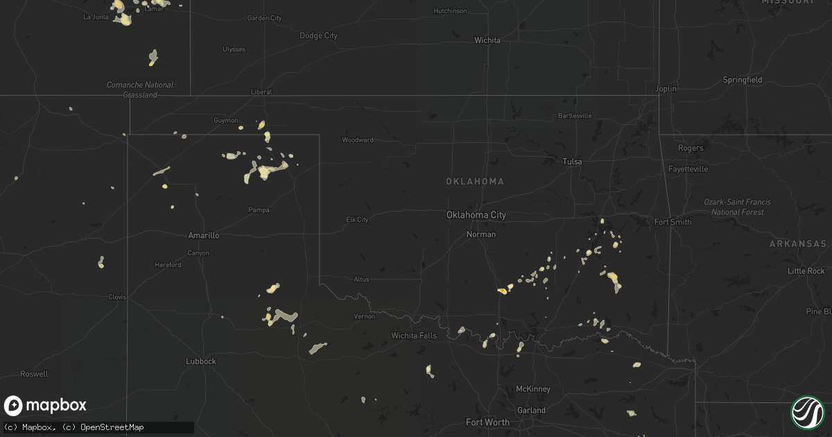
Hail Map in Oklahoma on August 8, 2016
Get this storm
August 8 map
$229
one time, instant access
Download today. No call, no setup
Keep the $229
Bought the map and want the full workflow? Apply the entire $229 to a subscription within 7 days. None of it is wasted.
Every map, not just this one
This buys you this map. Subscription and you get every map we run, in the markets you choose from a few cities to whole states to nationwide. Plus real-time alerts the moment a storm fires.
Contact data
Name, contact info, occupancy, even credit band for addresses in the footprint. You go from where it hit to who to call.
Become the source they trust
Unlimited branding weather history reports on demand. You already have the documented answer ready for the property owner, and you are the one who showed up with it.
Property data and RoofTrace estimates
Pull up any address you have got, its value and the exact code rules for that jurisdiction, straight from One Click Code. Then RoofTrace estimates the squares, pitch, and roof value, priced the way you price.
Storm reports in Oklahoma
Oklahoma
| Date | Description |
|---|---|
| 08/08/20165:50 PM CDT | 68 mph measured by the oklahoma mesonet near burneyville |
| 08/08/20165:30 PM CDT | 66 mph gust meaured by the oklahoma mesonet |
| 08/08/20162:35 PM CDT | Relayed by sulphur fd |
| 08/08/20162:35 PM CDT | A local report indicates 1.75 inch wind near DAVIS |
| 08/08/20162:35 PM CDT | Relayed by sulphus fd |
| 08/08/20162:35 PM CDT | A local report indicates 1.75 inch wind near SULPHUR |
All States Impacted by Hail Map on August 8, 2016
Cities Impacted by Hail Map on August 8, 2016
- Mcalester, OK
- Helena, MT
- Potter, NE
- Leighton, AL
- Red Oak, OK
- Kinta, OK
- Wilburton, OK
- Matador, TX
- Hawley, MN
- Barnesville, MN
- Childress, TX
- Turkey, TX
- Hermosa, SD
- Rushville, NE
- Gordon, NE
- Grand Junction, CO
- Sadler, TX
- Vega, TX
- Checotah, OK
- Eufaula, OK
- Waubun, MN
- Rapid City, SD
- Pittsburg, TX
- Gilmer, TX
- Wounded Knee, SD
- Pine Ridge, SD
- Longview, TX
- Midland, SD
- Hartley, TX
- Lance Creek, WY
- Newcastle, WY
- Las Animas, CO
- Hot Springs, SD
- Selby, SD
- Courtland, AL
- Lakota, ND
- Crary, ND
- Atwood, OK
- Fitzhugh, OK
- Stonewall, OK
- Roff, OK
- Gladewater, TX
- Twin Valley, MN
- Canadian, TX
- Henrietta, TX
- Jacksboro, TX
- Miami, TX
- Fort Stockton, TX
- Hay Springs, NE
- Eagle Butte, SD
- Wiley, CO
- McClave, CO
- Paducah, TX
- Harrisburg, NE
- Kadoka, SD
- Thermopolis, WY
- Worland, WY
- Hooker, OK
- Oglala, SD
- Oral, SD
- Smithwick, SD
- Chadron, NE
- Manderson, SD
- Davis, OK
- Sulphur, OK
- Presho, SD
- Ramah, CO
- Wanblee, SD
- Bairoil, WY
- Sidney, NE
- Peetz, CO
- Iliff, CO
- White River, SD
- Dix, NE
- Padroni, CO
- Tierra Amarilla, NM
- Lindrith, NM
- Moulton, AL
- Allen, OK
- Stinnett, TX
- Savanna, OK
- Gurley, NE
- Stuart, OK
- Grants, NM
- Montrose, CO
- Burneyville, OK
- Spruce Pine, AL
- Russellville, AL
- Jay Em, WY
- Muenster, TX
- Colorado Springs, CO
- Spearman, TX
- Calhan, CO
- Vivian, SD
- Scenic, SD
- Kyle, SD
- Gillette, WY
- Ada, MN
- Halstad, MN
- Shelly, MN
- Murdo, SD
- Mcville, ND
- Michigan, ND
- Stevensville, MT
- Victor, MT
- Clarksville, TX
- Annona, TX
- Nashoba, OK
- Simla, CO
- Matheson, CO
- Aneta, ND
- Springfield, CO
- Amistad, NM
- Lamar, CO
- Dumas, TX
- Northwood, ND
- Sugar City, CO
- Wall, SD
- Yoder, CO
- Syracuse, KS
- Perryton, TX
- Powderly, TX
- Arthur City, TX
- Balko, OK
- West Fargo, ND
- Tuskahoma, OK
- Clayton, OK
- Philip, SD
- Boise City, OK
- Devils Lake, ND
- Penn, ND
- Datil, NM
- Lead, SD
- Tucumcari, NM
- Mcalister, NM
- Grady, NM
- Deadwood, SD
- Duncan, AZ
- Rifle, CO
- Whitewater, CO
- Gateway, CO
- White Earth, MN
- Ogema, MN
- Mount Pleasant, TX
- Boone, CO
- Sheridan Lake, CO
- Tupelo, OK
- Centrahoma, OK
- Quinton, OK
- Stigler, OK
- Rush, CO
- Hill City, SD
- Upton, WY
- Pueblo, CO
- Holly, CO
- Higgins, TX
- Phil Campbell, AL
- Albuquerque, NM
- Dalhart, TX
- Hillsboro, AL
- Box Elder, SD
- Madison, AL
- Jemez Springs, NM
- Hardesty, OK
- Long Valley, SD
- Martin, SD
- Elora, TN
- Huntland, TN
- Hugo, OK
- Rolla, ND
- Belcourt, ND
- Mapleton, ND
- Edgemont, SD
- Ocate, NM
- Gruver, TX
- Vidor, TX
- Ada, OK
- Gainesville, TX
- Marietta, OK
- Woodson, TX
- Arlington, CO
- Dunseith, ND
- Hamilton, MT
- Newell, SD
- Calvin, OK
- Snow, OK
- Rattan, OK
- Bowie, AZ
- Elfrida, AZ
- Pearce, AZ
- Whitesboro, TX
- Eads, CO
- Callaway, MN
- Ulen, MN
- Wapanucka, OK
- Overbrook, OK
- Orange, TX
- Fountain, CO
- Mosquero, NM
- Fairburn, SD
- Nemo, SD
- Tuscumbia, AL
- Johnson, KS
- Milesville, SD
- Lockney, TX
- Rocklake, ND
- Throckmorton, TX
- Kenefic, OK
- Quemado, NM
- Clinton, MT
- Conifer, CO
- Olathe, CO
- Allen, SD
- Winslow, AZ
- Ryan, OK
- Clayton, NM
- Soper, OK
- Cary, NC
- Blossom, TX
- Kiowa, OK
- Elgin, AZ
- Boswell, OK
- Moorhead, MN
- Glyndon, MN
- Sherman, TX
- Pottsboro, TX
- Akaska, SD
- Chappell, NE
- Patagonia, AZ
- Lakeview, TX
- Norris, SD
- Littleton, CO
- Town Creek, AL
- Des Moines, NM
- Corvallis, MT
- Kendall, KS
- Nocona, TX
- Laguna, NM
- Monticello, UT
- Stanley, NM
- Stratford, TX
- Antlers, OK
- Draper, SD
- Hasty, CO


