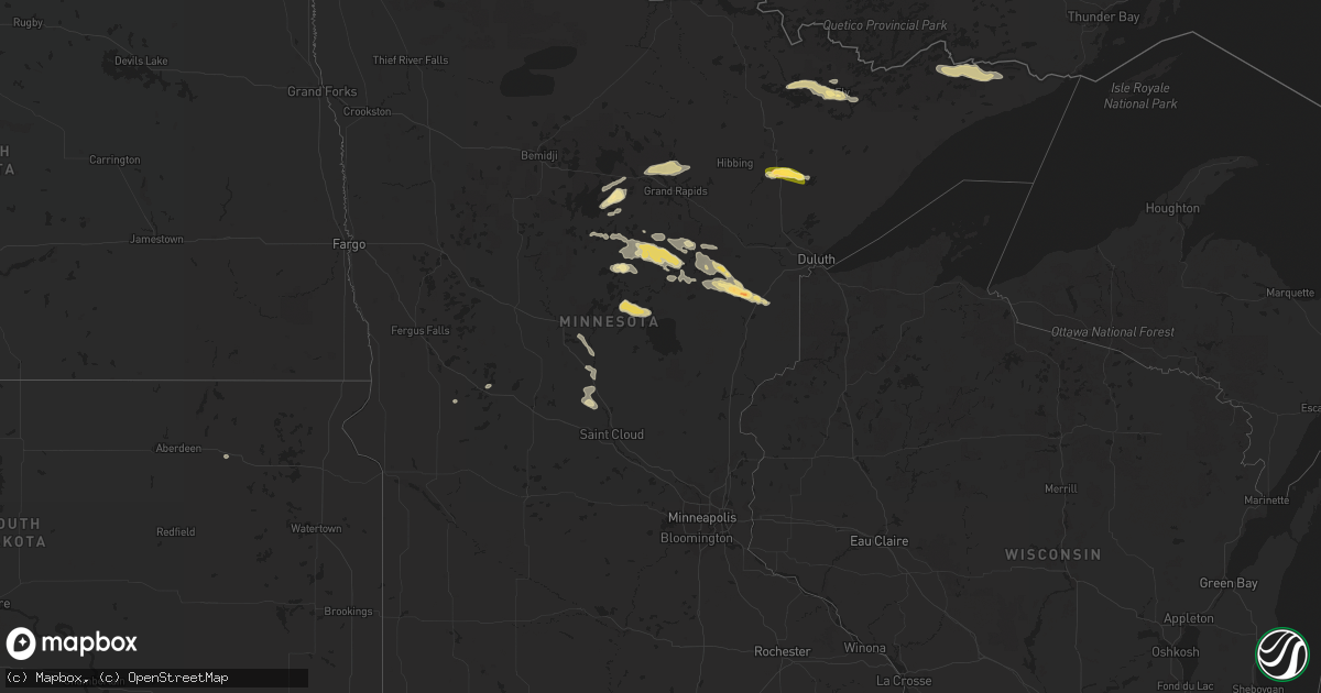
Hail Map in Minnesota on August 8, 2015
Get this storm
August 8 map
$229
one time, instant access
Download today. No call, no setup
Keep the $229
Bought the map and want the full workflow? Apply the entire $229 to a subscription within 7 days. None of it is wasted.
Every map, not just this one
This buys you this map. Subscription and you get every map we run, in the markets you choose from a few cities to whole states to nationwide. Plus real-time alerts the moment a storm fires.
Contact data
Name, contact info, occupancy, even credit band for addresses in the footprint. You go from where it hit to who to call.
Become the source they trust
Unlimited branding weather history reports on demand. You already have the documented answer ready for the property owner, and you are the one who showed up with it.
Property data and RoofTrace estimates
Pull up any address you have got, its value and the exact code rules for that jurisdiction, straight from One Click Code. Then RoofTrace estimates the squares, pitch, and roof value, priced the way you price.
Storm reports in Minnesota
Minnesota
| Date | Description |
|---|---|
| 08/08/20155:20 PM CDT | Trees down. |
| 08/08/20155:20 PM CDT | A local report indicates 1.75 inch wind near KETTLE RIVER |
| 08/08/20154:38 PM CDT | Mostly pea sized hail with some quarter sized hail. |
| 08/08/20154:34 PM CDT | Lots of 1 inch hail. |
| 08/08/20154:30 PM CDT | A few trees down. Heavy rain. |
| 08/08/20154:25 PM CDT | Spotter reports one 800 pound hay bale demolished over a field. Along with 8-12 inch diameter live trees down. Time estimated from radar. |
| 08/08/20157:07 AM CDT | 4 inch branch broken off healthy tree. |
| 08/07/20157:54 PM CDT | A local report indicates 1.00 inch wind near 13 ESE GUNFLINT LAKE |
All States Impacted by Hail Map on August 8, 2015
Cities Impacted by Hail Map on August 8, 2015
- Bovina, TX
- Texico, NM
- Friona, TX
- Corning, IA
- Villisca, IA
- Ellis, KS
- Hays, KS
- Elmwood, NE
- Cimarron, KS
- Silas, AL
- Hereford, TX
- Bonita, LA
- Union, NE
- Philip, SD
- Stanton, IA
- Clovis, NM
- Weskan, KS
- White River, SD
- Deerfield, KS
- Belle Fourche, SD
- Saint Onge, SD
- Bethune, CO
- Freeport, FL
- Palisade, MN
- Jacobson, MN
- Fort Meade, SD
- Sturgis, SD
- Florence, MS
- Braxton, MS
- Holdingford, MN
- Bowlus, MN
- Essex, IA
- Grand Rapids, MN
- Nashwauk, MN
- Bovey, MN
- Holcomb, KS
- Foster, MO
- Garden City, KS
- Bunker Hill, KS
- Dorrance, KS
- Lucas, KS
- Luray, KS
- Maitland, MO
- Forest City, MO
- Mound City, MO
- Oregon, MO
- Deer River, MN
- Walnut Grove, MO
- Morrisville, MO
- Brighton, MO
- Springfield, MO
- Fair Grove, MO
- Willard, MO
- Pleasant Hope, MO
- Stella, NE
- Humboldt, NE
- Tecumseh, NE
- Nemaha, NE
- Johnson, NE
- Elk Creek, NE
- Verdon, NE
- Rulo, NE
- Falls City, NE
- Craig, MO
- Shubert, NE
- Auburn, NE
- Burlington, CO
- Lumberton, MS
- Moose Lake, MN
- Cromwell, MN
- Kettle River, MN
- Barnum, MN
- Millry, AL
- Crosslake, MN
- Crosby, MN
- Fifty Lakes, MN
- Emily, MN
- La Harpe, KS
- Colony, KS
- Fort Pierre, SD
- Flagstaff, AZ
- Tuba City, AZ
- Muleshoe, TX
- Farragut, IA
- Stratton, CO
- El Dorado Springs, MO
- Rosendale, MO
- Amazonia, MO
- Fairfax, MO
- Bolckow, MO
- Savannah, MO
- Table Rock, NE
- Fillmore, MO
- Barnard, MO
- Sterling, NE
- Graham, MO
- Wiggins, MS
- Newhebron, MS
- Pinola, MS
- Spearfish, SD
- Syracuse, NE
- Unadilla, NE
- Yazoo City, MS
- Bentonia, MS
- Beaumont, MS
- McLain, MS
- Wall, SD
- Nisland, SD
- Newell, SD
- Bison, KS
- Otis, KS
- Wanblee, SD
- Stringer, MS
- Platte, SD
- Leroy, AL
- Jackson, AL
- Milesville, SD
- Howes, SD
- Gilman City, MO
- Uniontown, KS
- Redfield, KS
- Augusta, IL
- Camden, IL
- Bowen, IL
- La Prairie, IL
- Huntsville, IL
- Carthage, IL
- Plymouth, IL
- Grand Marais, MN
- Kadoka, SD
- Mobile, AL
- Eight Mile, AL
- Ely, MN
- Chunchula, AL
- Walker, MO
- Harwood, MO
- Gruver, TX
- Nevada, MO
- Milo, MO
- Vancleave, MS
- Eveleth, MN
- Gilbert, MN
- Makinen, MN
- Nebraska City, NE
- Wood, SD
- Winterset, IA
- Van Meter, IA
- Cumming, IA
- Saraland, AL
- Eagle Butte, SD
- Gettysburg, SD
- Panama City Beach, FL
- Panama City, FL
- Enning, SD
- Wasta, SD
- Gorham, KS
- Russell, KS
- Sundance, WY
- Beulah, WY
- Whitewood, SD
- Deadwood, SD
- Aitkin, MN
- Forbes, MN
- Petal, MS
- Hattiesburg, MS
- Dix, NE
- Dunbar, NE
- Wright, MN
- Tamarack, MN
- Maryville, MO
- Waldo, KS
- Rock Port, MO
- Westboro, MO
- Hope Hull, AL
- Hayneville, AL
- Richards, MO
- Fontana, KS
- Hume, MO
- La Cygne, KS
- Rich Hill, MO
- Butler, MO
- Pleasanton, KS
- Amoret, MO
- Paola, KS
- Gregory, SD
- Jetmore, KS
- Padroni, CO
- Brainerd, MN
- Merrifield, MN
- Ironton, MN
- Deerwood, MN
- Guilford, MO
- Stanberry, MO
- Cannon Afb, NM
- Natoma, KS
- Moorcroft, WY
- Leakesville, MS
- Richton, MS
- Neely, MS
- Sylvan Grove, KS
- Ovett, MS
- Jayess, MS
- Monticello, MS
- Little Falls, MN
- Riverton, IA
- Northboro, IA
- Hamburg, IA
- Shenandoah, IA
- Wagarville, AL
- Moselle, MS
- Stonewall, MS
- Meridian, MS
- Quitman, MS
- Hunter, KS
- Princeton, MO
- Arapahoe, CO
- Sharon Springs, KS
- Cheyenne Wells, CO
- Kit Carson, CO
- Remer, MN
- Federal Dam, MN
- Alexandria, MN
- Lucedale, MS
- Blanchard, IA
- Coin, IA
- Scenic, SD
- New Underwood, SD
- Sheridan Lake, CO
- Peru, NE
- Nehawka, NE
- Watson, MO
- Avoca, NE
- Randolph, IA
- Nodaway, IA
- Percival, IA
- Tabor, IA
- Tarkio, MO
- Pacific Junction, IA
- Imogene, IA
- Murdock, NE
- Weeping Water, NE
- Brownville, NE
- Sidney, IA
- Otoe, NE
- Thurman, IA
- Plattsmouth, NE
- Murray, NE
- Red Oak, IA
- Manley, NE
- Kendall, KS
- Syracuse, KS
- Manter, KS
- Lakin, KS
- Johnson, KS
- Plainville, KS
- Belvidere, SD
- Midland, SD
- White Owl, SD
- Winner, SD
- Laurel, MS
- Mcgregor, MN
- Poplarville, MS
- Osborne, KS
- Swatara, MN
- Hill City, MN
- Theodore, AL
- Carriere, MS
- Tibbie, AL
- Hayes, SD
- Sheldon, MO
- Royalton, MN
- Lead, SD
- Chillicothe, MO
- Breckenridge, MO
- Lock Springs, MO
- Gallatin, MO
- Jamesport, MO
- Wilson, KS
- Portales, NM
- Ridgeway, MO
- Pioneer, LA
- Groton, SD
- Aladdin, WY
- Bascom, FL
- Vicksburg, MS
- Bristol, FL
- Columbia, MS
- Winslow, AZ
- Whiterocks, UT
- Hamill, SD
- Witten, SD
- Ideal, SD
- Leupp, AZ
- Satsuma, AL
- Creola, AL
- Greenfield, IA
- Rush Center, KS
- Prattville, AL
- Autaugaville, AL
- Moundville, MO
- Kimball, SD
- Purvis, MS
- Holly, CO
- Ravenwood, MO
- Parnell, MO
- Gentry, MO
- Frankville, AL
- Glenwood, IA
- Clarinda, IA
- Elmo, MO
- Louisville, NE
- Malvern, IA
- Eagle, NE
- Burlington Junction, MO
- Skidmore, MO
- Greenwood, NE
- Sheridan, MO
- Elliott, IA
- Clyde, MO
- Alvo, NE
- Conception Junction, MO
- King City, MO
- Darlington, MO
- Mer Rouge, LA
- Citronelle, AL
- West Point, IL
- Basco, IL
- Orient, IA
- Owanka, SD
- Quinn, SD
- Rapid City, SD
- Caputa, SD
- Interior, SD
- Shubuta, MS
- Tower, MN
- Fort Ripley, MN
- Cushing, MN
- Tallulah, LA
- Moran, KS
- Kincaid, KS
- Leola, AR
- Carthage, AR
- Marianna, FL
- Greenwood, FL
- Ellisville, MS
- Seminary, MS
- Prairie City, IA
- McCracken, KS
- Prescott, KS
- Deerfield, MO
- Florala, AL
- Hackensack, MN
- Longville, MN
- Brock, NE
- Macksburg, IA
- Creston, IA
- Prole, IA
- West Des Moines, IA
- Des Moines, IA
- Indianola, IA
- Norwalk, IA
- Green City, MO
- Unionville, MO
- Pollock, MO
- Stratford, TX
- Clearmont, MO
- Lowndesboro, AL
- Fort Scott, KS
- Bronson, KS
- Mapleton, KS
- Selma, AL
- Harrisville, MS
- New Augusta, MS
- Altha, FL
- Bazine, KS
- Vernon, FL
- Ponce De Leon, FL
- Carbon, IA
- Wakeeney, KS
- Hamburg, AR
- Outing, MN
- Powersville, MO
- Transylvania, LA
- Dalhart, TX
- Spearman, TX
- Silver Creek, MS
- Prentiss, MS
- Picayune, MS
- Blue Mound, KS
- Ashland, NE
- Brookhaven, MS
- Bogue Chitto, MS
- Long Valley, SD
- Pennington, AL
- Thermopolis, WY
- Runnells, IA
- Carlisle, IA
- Pleasant Hill, IA
- Burdett, KS
- Rea, MO
- Rolla, KS
- Richfield, KS
- Ness City, KS
- Timewell, IL
- Coffeeville, AL
- Kensington, MN
- Lamar, MO
- Hugoton, KS
- Okaton, SD
- Kokomo, MS
- Foxworth, MS
- Strafford, MO
- Aldrich, MO
- Springfield, CO
- Tyler, AL
- Blountstown, FL
- Tribune, KS
- McFall, MO
- Hoisington, KS
- Edwards, MS
- Bolton, MS
- Butler, AL
- McIntosh, AL
- Bronaugh, MO
- Terry, MS
- Garnett, KS
- Kinston, AL
- Elba, AL
- Samson, AL
- Hamilton, IL
- Warsaw, IL
- Farwell, TX
- Newtown, MO
- Vale, SD
- Summit, MS
- Miller, MO
- Rice, MN
- Cainsville, MO
- Spickard, MO
- Stockton, MO
- Eagleville, MO
- Blythedale, MO
- Saint Stephens, AL
- Lacombe, LA
- Mandeville, LA
- Waynesboro, MS
- Port Saint Joe, FL
- Sutter, IL
- Alexandria, MO
- Luverne, AL
- Brantley, AL
- Grey Eagle, MN
- Dadeville, MO
- Letohatchee, AL
- Brooklyn, MS
- Bastrop, LA
- Mound City, KS
- Mendenhall, MS
- Melvin, AL
- Iron, MN


