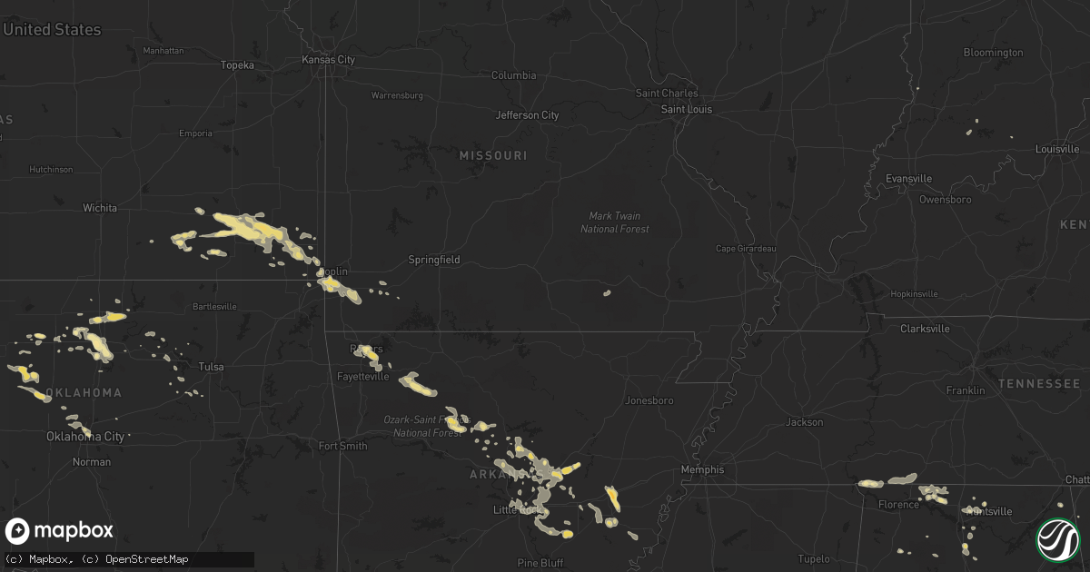
Hail Map in Oklahoma on August 8, 2011
Get this storm
August 8 map
$229
one time, instant access
Download today. No call, no setup
Keep the $229
Bought the map and want the full workflow? Apply the entire $229 to a subscription within 7 days. None of it is wasted.
Every map, not just this one
This buys you this map. Subscription and you get every map we run, in the markets you choose from a few cities to whole states to nationwide. Plus real-time alerts the moment a storm fires.
Contact data
Name, contact info, occupancy, even credit band for addresses in the footprint. You go from where it hit to who to call.
Become the source they trust
Unlimited branding weather history reports on demand. You already have the documented answer ready for the property owner, and you are the one who showed up with it.
Property data and RoofTrace estimates
Pull up any address you have got, its value and the exact code rules for that jurisdiction, straight from One Click Code. Then RoofTrace estimates the squares, pitch, and roof value, priced the way you price.
Storm reports in Oklahoma
Oklahoma
| Date | Description |
|---|---|
| 08/08/20116:55 PM CDT | A local report indicates 69 MPH wind near 5 E ORLANDO |
| 08/08/20116:50 PM CDT | A local report indicates 63 MPH wind near 7 SSE RED ROCK |
| 08/08/20116:45 PM CDT | A local report indicates 62 MPH wind near 7 SSE RED ROCK |
| 08/08/20116:35 PM CDT | The roof at the hospital sustained damage. One other home sustained major damage. Numerous power poles and lines are down over a 4 to 5 block area. Power was knocked ou |
| 08/08/20116:25 PM CDT | Several large barns were heavily damaged. Several power poles and trees were snapped or blown down. |
| 08/08/20116:23 PM CDT | A large portion of the roof at the lutheran church was destroyed. |
| 08/08/20116:05 PM CDT | A local report indicates 73 MPH wind near 4 SSE BILLINGS |
| 08/08/20116:05 PM CDT | A local report indicates 70 MPH wind near VANCE AIR FORCE BASE |
| 08/08/20116:01 PM CDT | A local report indicates 63 MPH wind near VANCE AIR FORCE BASE |
| 08/08/20116:00 PM CDT | Several 80-foot transmission poles and lines were downed. Four to six homes sustained damage as the lines fell. |
| 08/08/20115:50 PM CDT | A local report indicates 96 MPH wind near 1 WSW LAHOMA |
| 08/08/20115:45 PM CDT | A local report indicates 75 MPH wind near OKEENE |
| 08/08/20115:45 PM CDT | Several outbuildings destroyed with heavy tree damage |
| 08/08/20115:40 PM CDT | Significant damage to trees was reported around the town of goltry. |
| 08/07/20118:58 PM CDT | Barn damaged...same barn was damaged by the tornado on may 24th...wind estimated 80 mph. |
| 08/07/20118:55 PM CDT | A local report indicates 64 MPH wind near TINKER AIR FORCE BASE |
| 08/07/20118:45 PM CDT | Power lines reported at the ba expressway and 145th east ave. Possibly resulted in a fire. |
| 08/07/20118:44 PM CDT | A local report indicates 63 MPH wind near TINKER AIR FORCE BASE |
| 08/07/20118:41 PM CDT | A local report indicates 58 MPH wind near TINKER AIR FORCE BASE |
| 08/07/20118:40 PM CDT | A local report indicates 66 MPH wind near 4 W HECTORVILLE |
| 08/07/20118:32 PM CDT | 8 to 10 power poles snapped along 221st st. Women trapped in vehicle by power lines. |
| 08/07/20118:30 PM CDT | Measured at the lone star school schoolnet. |
| 08/07/20118:25 PM CDT | A local report indicates 71 MPH wind near 6 N OKLAHOMA CITY |
| 08/07/20118:05 PM CDT | Numerous fences and power poles blown down. Time estimated based on radar |
| 08/07/20117:55 PM CDT | The oklahoma county emergency mangement surveyed damage near rockwell avenue and memorial road. One hame sustained roof damage. A large power pole was shattered. Eleven |
| 08/07/20117:50 PM CDT | Off duty nws employee reported 60 to 70 mph wind gusts |
| 08/07/20117:43 PM CDT | A house lost 90 percent of its roof. The roof was scattered approximately 100 yards to the east. A metal barn east of the house was completely destroyed. Other barns an |
| 08/07/20117:25 PM CDT | A mobile home was blown over on the south side of town. |
| 08/07/20117:23 PM CDT | A local report indicates 58 MPH wind near 1 NE OKARCHE |
| 08/07/20117:20 PM CDT | A local report indicates 59 MPH wind near 7 N COYLE |
| 08/07/20117:20 PM CDT | A local report indicates 59 MPH wind near 2 W STILLWATER |
| 08/07/20117:15 PM CDT | A tree was knocked over and several large tree limbs were blown down on the campus of oklahoma state university. |
| 08/07/20117:15 PM CDT | The damage began about 5 miles west of weatherford. Numerous power poles were blown down as the wind got closer to weatherford. Two semi tractor trailers and two automo |
| 08/07/20117:14 PM CDT | A local report indicates 72 MPH wind near 2 NNW STILLWATER |
| 08/07/20117:10 PM CDT | A local report indicates 67 MPH wind near 2 W STILLWATER |
| 08/07/20117:05 PM CDT | A local report indicates 61 MPH wind near 2 W STILLWATER |
| 08/07/20117:05 PM CDT | A local report indicates 64 MPH wind near 7 N COYLE |
| 08/07/20117:03 PM CDT | A local report indicates 80 MPH wind near 2 NNW STILLWATER |
| 08/07/20117:00 PM CDT | Power poles blown down. Four large hail bales were rolled several feet across a street. |
| 08/07/20117:00 PM CDT | Numerous power poles down and estimated 70 mph winds |
All States Impacted by Hail Map on August 8, 2011
Cities Impacted by Hail Map on August 8, 2011
- Metamora, IL
- East Peoria, IL
- Chillicothe, IL
- Dunlap, IL
- Peoria, IL
- Mossville, IL
- Edelstein, IL
- West Liberty, KY
- Ohio, IL
- Princeton, IL
- Malden, IL
- La Moille, IL
- Crawfordville, GA
- Bird City, KS
- Oklahoma City, OK
- Elk City, KS
- Elwood, NE
- Geneseo, IL
- Atkinson, IL
- Beebe, AR
- Searcy, AR
- Center Ridge, AR
- Palisade, NE
- Wauneta, NE
- Riverton, NE
- Smith Center, KS
- Lake Wales, FL
- Stinnett, KY
- Newcastle, WY
- Monett, MO
- Walton, IN
- Mount Vernon, AR
- Lebanon Junction, KY
- Boston, KY
- Lafayette, IN
- Howard, KS
- Grenola, KS
- Moline, KS
- Brady, NE
- Maxwell, NE
- Harpersville, AL
- Childersburg, AL
- Oswego, KS
- Altamont, KS
- Gillette, WY
- Monument, KS
- Beeler, KS
- Savannah, GA
- Seneca, MO
- Okarche, OK
- Colby, KS
- Oakley, KS
- Tonkawa, OK
- Trenton, NE
- Stratton, NE
- Ramer, AL
- Pawnee, OK
- Lancaster, KY
- Wilmore, KY
- Moro, AR
- Brinkley, AR
- Aubrey, AR
- Wheatley, AR
- Lyons, GA
- Clinton, IA
- Bryant, IA
- Athens, AL
- Rogersville, AL
- Bee Branch, AR
- Damascus, AR
- Humnoke, AR
- Humphrey, AR
- Stuttgart, AR
- Duluth, MN
- Cloquet, MN
- Hennessey, OK
- Ames, OK
- Metter, GA
- Neosho, MO
- Morocco, IN
- Rensselaer, IN
- Brook, IN
- Galesburg, KS
- Erie, KS
- Thayer, KS
- Parsons, KS
- Saint Paul, KS
- Kingfisher, OK
- Okeene, OK
- Prophetstown, IL
- Tampico, IL
- McRae, AR
- Des Arc, AR
- Ward, AR
- Hickory Plains, AR
- Carlisle, AR
- Huntsville, AR
- Champion, NE
- West Point, MS
- Aberdeen, MS
- Liberty, IN
- Gove, KS
- Quinter, KS
- Bristow, OK
- Kellyville, OK
- Tryon, NE
- North Platte, NE
- Lemoyne, NE
- Keystone, NE
- Ogallala, NE
- Joplin, MO
- Bennett, IA
- New Liberty, IA
- Heflin, AL
- Woodland, AL
- De Valls Bluff, AR
- Holly Grove, AR
- Clarendon, AR
- Edison, GA
- Cuthbert, GA
- Ness City, KS
- Jetmore, KS
- Eustis, NE
- Hawkinsville, GA
- Unadilla, GA
- Baldwin, IA
- Lebanon, NE
- Levant, KS
- Hickory Flat, MS
- Potts Camp, MS
- Christiana, TN
- Falkville, AL
- Hartselle, AL
- Soperton, GA
- Rockledge, GA
- Rankin, IL
- Frankfort, KY
- Fort Gay, WV
- Louisa, KY
- Rock Falls, IL
- Mitchell, GA
- Bardstown, KY
- Prattville, AL
- Princeville, IL
- Montgomery, AL
- Ashland, MS
- Senoia, GA
- Madrid, NE
- Holly Springs, MS
- Macon, GA
- Gray, GA
- Williamsport, IN
- West Lebanon, IN
- Collinwood, TN
- Alvin, IL
- Rossville, IL
- Henning, IL
- Paxton, NE
- Elsie, NE
- Genoa, WV
- Fort Stewart, GA
- Richmond Hill, GA
- Vidalia, GA
- Saginaw, MN
- Warrenton, GA
- Camak, GA
- Norwood, GA
- Moultrie, GA
- Funston, GA
- Farragut, TN
- Louisville, TN
- Knoxville, TN
- Moorefield, NE
- Booneville, KY
- East Dublin, GA
- Fitzpatrick, AL
- Hornsby, TN
- Pocahontas, TN
- Bethel Springs, TN
- Selmer, TN
- Coxs Creek, KY
- Shepherdsville, KY
- Talladega, AL
- Loveland, OH
- Tiplersville, MS
- Walnut, MS
- Lenora, KS
- Cambridge, IL
- Haxtun, CO
- Fleming, CO
- Iliff, CO
- Lagrange, GA
- Parks, NE
- Fall River, KS
- Cobbtown, GA
- Haleyville, AL
- Phil Campbell, AL
- Gibson, GA
- Norton, KS
- Hill City, KS
- Lahoma, OK
- Carrier, OK
- Cissna Park, IL
- Arthur, NE
- Hayes Center, NE
- Girard, KS
- Cherokee, KS
- Pittsburg, KS
- Arlington, GA
- Granby, MO
- Barbourville, KY
- Bryants Store, KY
- Gate City, VA
- Brimfield, IL
- Hanna City, IL
- Edwards, IL
- Myrtle, MS
- New Albany, MS
- Morrison, IL
- Thomson, IL
- Fulton, IL
- Mary Alice, KY
- Harlan, KY
- Pelsor, AR
- Gordon, WI
- Witts Springs, AR
- Hector, AR
- Minong, WI
- Solon Springs, WI
- Hayward, WI
- Elko, GA
- Pineview, GA
- Springfield, KY
- Lebanon, KY
- Toone, TN
- Medon, TN
- Hindsville, AR
- Winona, KS
- Benkelman, NE
- Brewster, KS
- Imperial, NE
- McDonald, KS
- Saint Francis, KS
- Black Hawk, SD
- Piedmont, SD
- Amory, MS
- Rogers, AR
- Lowell, AR
- Funk, NE
- Holdrege, NE
- Fairmount, GA
- Ranger, GA
- Decatur, AL
- Witter, AR
- Ponca, AR
- Kingston, AR
- Saltillo, MS
- Guntown, MS
- Benedict, KS
- Fredonia, KS
- Neodesha, KS
- Altoona, KS
- Sandersville, GA
- Ochlocknee, GA
- Thomasville, GA
- Cairo, GA
- Kingsport, TN
- Gothenburg, NE
- Middleton, TN
- Camilla, GA
- Coal Valley, IL
- Orion, IL
- Osco, IL
- Milan, IL
- Lynn Center, IL
- Andover, IL
- Coggon, IA
- Central City, IA
- Center Point, IA
- Walker, IA
- Lexington, AL
- Goodwater, AL
- Erie, IL
- Lyndon, IL
- Fenton, IL
- Connersville, IN
- Rushville, IN
- Falmouth, IN
- Carthage, IN
- Knightstown, IN
- Bolivar, TN
- Esko, MN
- Greenbrier, AR
- Quitman, AR
- Sibley, IL
- Cullman, AL
- Dixon, IA
- Irvine, KY
- Utica, KS
- Dighton, KS
- Madison, AL
- Mays, IN
- Brownsville, IN
- Arlington, IN
- Greenfield, IN
- Talmoon, MN
- Deer River, MN
- Dublin, GA
- Perry, OK
- Peru, IN
- Bunker Hill, IN
- Montezuma, GA
- Oglethorpe, GA
- Stapleton, NE
- Tipton, IA
- Stockton, IA
- Wilcox, NE
- Bigfork, MN
- Marcell, MN
- Kenansville, FL
- Galena, KS
- Hazen, AR
- Logansport, IN
- Dover, AR
- Monticello, IA
- Hopkinton, IA
- Covington, KY
- Ft Mitchell, KY
- Silver Grove, KY
- Newport, KY
- Fort Thomas, KY
- Cincinnati, OH
- Latonia, KY
- Wilton, IA
- Hattieville, AR
- Cleveland, AR
- Fort Benning, GA
- Wood Lake, MN
- Maquoketa, IA
- Charlotte, IA
- Goose Lake, IA
- Palo, IA
- Cedar Rapids, IA
- Van Orin, IL
- Willisburg, KY
- Mackville, KY
- Bell Buckle, TN
- Beechgrove, TN
- Superior, WI
- Bloomington, NE
- Anderson, AL
- Clinton, AR
- London, KY
- Dadeville, AL
- Jacksons Gap, AL
- Walkersville, WV
- Napier, WV
- Ireland, WV
- Jewell, GA
- Louisville, GA
- Avera, GA
- Jeffersonville, GA
- Mason, WI
- Sherwood, AR
- Earlville, IL
- Sheridan, IL
- Leland, IL
- Waynesboro, TN
- Lawrenceburg, TN
- Buena Vista, GA
- West Branch, IA
- Enid, OK
- Franklin, NE
- Cherryvale, KS
- Chanute, KS
- Saint Charles, MN
- Dover, MN
- Plainview, MN
- Mableton, GA
- Austell, GA
- Springdale, AR
- Higginson, AR
- Griffithville, AR
- Sparks, GA
- Lenox, GA
- Chadron, NE
- Reidsville, GA
- Big Stone Gap, VA
- Scotland, AR
- Perry, FL
- Naponee, NE
- Iron City, TN
- England, AR
- Parthenon, AR
- Dayton, IN
- Meigs, GA
- Walnut, IL
- Morgan, GA
- Ponca City, OK
- Langworthy, IA
- Anamosa, IA
- Mount Judea, AR
- Meno, OK
- Jacksonville, AR
- Vinemont, AL
- Deer, AR
- Mount Vernon, KY
- Serena, IL
- Springfield, GA
- Rincon, GA
- Blakely, GA
- Preston, IA
- Spragueville, IA
- Scott, AR
- El Paso, AR
- North Little Rock, AR
- Wabbaseka, AR
- Lonoke, AR
- Rose Bud, AR
- Cabot, AR
- Maumelle, AR
- Austin, AR
- Vilonia, AR
- Garner, AR
- Little Rock, AR
- Enola, AR
- Keo, AR
- Romance, AR
- Columbus, KS
- McRae Helena, GA
- Alpine, AL
- Farnam, NE
- Delmar, IA
- Jerusalem, AR
- Woodbury, GA
- Saint Johns, FL
- Orlando, OK
- Wilsonville, NE
- Bartley, NE
- Williamsburg, OH
- Batavia, OH
- Jakin, GA
- Moulton, AL
- Gridley, IL
- Flanagan, IL
- Quapaw, OK
- Geneva, AL
- Newburgh, NY
- Marlboro, NY
- Carlton, MN
- Abbeville, AL
- Martinton, IL
- Glenwood, GA
- Orlando, WV
- Burnsville, WV
- Midway, AL
- Ely, IA
- Freeport, FL
- Atwood, KS
- Mcloud, OK
- Meeker, OK
- Lexa, AR
- Billings, OK
- Scammon, KS
- McCune, KS
- Mound Valley, KS
- Longton, KS
- West Mineral, KS
- Dennis, KS
- Laura, IL
- Elmwood, IL
- Williamsfield, IL
- Trivoli, IL
- Jasper, IN
- Dubois, IN
- Menlo, GA
- Hamilton, MS
- Manchester, KY
- Falkner, MS
- Ripley, MS
- Fayetteville, AR
- Cave Springs, AR
- Bentonville, AR
- Donahue, IA
- Mechanicsville, IA
- Warner Robins, GA
- Byron, GA
- Albany, GA
- De Witt, IA
- Samson, AL
- Rydal, GA
- Waleska, GA
- Waterloo, AL
- Watonga, OK
- Hitchcock, OK
- McCook, NE
- Donovan, IL
- Lake City, FL
- Columbus, GA
- Huntsville, TN
- Pelham, GA
- Verona, MO
- Pierce City, MO
- Aurora, MO
- Harvest, AL
- Sapulpa, OK
- Flomaton, AL
- Mendota, IL
- Arlington, IL
- Stanwood, IA
- Loretto, TN
- Saint Joseph, TN
- Savannah, TN
- Sanderson, FL
- Dahinda, IL
- Hazlehurst, GA
- Avon, IL
- Moreland, GA
- Dahlonega, GA
- Dawsonville, GA
- Brookville, IN
- Metamora, IN
- Oaktown, IN
- Beaverville, IL
- Belview, MN
- Clarksdale, MS
- Richland, GA
- Red Rock, OK
- Atkins, IA
- Shellsburg, IA
- Lithonia, GA
- Cordell, OK
- Chatsworth, GA
- Norcatur, KS
- Cambridge, NE
- Eastman, GA
- Dry Branch, GA
- Fort Mitchell, AL
- Scottsbluff, NE
- Garber, OK
- Milledgeville, GA
- Morris, IL
- Pine Mountain, GA
- Wrenshall, MN
- Lake Nebagamon, WI
- Onslow, IA
- Prentice, WI
- Murphy, NC
- Rapid City, SD
- Osage, OK
- Baxter Springs, KS
- Riverton, KS
- Jacobson, MN
- Douglas, OK
- Fairmont, OK
- Max, MN
- Wirt, MN
- Otterbein, IN
- West Lafayette, IN
- Elkmont, AL
- Ulm, AR
- Covington, OK
- Wetumpka, AL
- Middletown, OH
- Huntsville, AL
- Dumas, MS
- Henry, IL
- Bradford, IL
- Putnam, IL
- Belden, MS
- Blue Springs, MS
- Weatherford, OK
- Hay Springs, NE
- Kankakee, IL
- Wessington Springs, SD
- Alpena, SD
- Mitchell, NE
- Varna, IL
- Gordon, GA
- Cypress Inn, TN
- Westpoint, TN
- Florence, AL
- Orlando, KY
- Bloomingdale, GA
- Sparta, NC
- Ennice, NC
- Ashkum, IL
- Crawfordville, FL
- Melvin, IL
- Zumbrota, MN
- Bradyville, TN
- Shelbyville, TN
- Conway, AR
- Plumerville, AR
- Wooster, AR
- Springfield, AR
- Mounds, OK
- Lutts, TN
- Winchester, KY
- Franklin, OH
- Lebanon, OH
- Weir, KS
- Stockville, NE
- Corbin, KY
- Stark City, MO
- Stella, MO
- O'Brien, FL
- Severy, KS
- Hildreth, NE
- Republican City, NE
- Two Harbors, MN
- Cordova, AL
- Defuniak Springs, FL
- Nardin, OK
- Independence, KS
- Byromville, GA
- Terlton, OK
- Cleveland, OK
- Valley, AL
- Salem, AL
- Hamilton, GA
- Sabula, IA
- Hibbing, MN
- Pembroke, GA
- Maramec, OK
- Redwood Falls, MN
- Port Wing, WI
- Chaplin, KY
- Lawrenceburg, KY
- Midway, GA
- Lily, KY
- Salt Lick, KY
- Somerset, KY
- Liberty, KY
- Damascus, GA
- Newton, GA
- Bloomfield, KY
- Hominy, OK
- Venango, NE
- Cascade, IA
- Jackson, TN
- Lodgepole, NE
- Luther, OK
- Pavo, GA
- Hunter, OK
- Lowndesboro, AL
- Waverly, AL
- Lulu, FL
- Kewanee, IL
- Annawan, IL
- Ralston, OK
- Fairfax, OK
- Milltown, IN
- Tellico Plains, TN
- Drumright, OK
- Mannford, OK
- Shorterville, AL
- Killen, AL
- Camp Hill, AL
- Mayo, FL
- Jackson, KY
- Etowah, TN
- Lucien, OK
- Yukon, OK
- Keavy, KY
- Evergreen, AL
- Mathews, AL
- Elk Falls, KS
- Nancy, KY
- Peru, IL
- Buffalo Gap, SD
- Sparland, IL
- Coolidge, GA
- Ashland, WI
- Danville, GA
- Atalissa, IA
- Jasper, AL
- Danforth, IL
- Morrison, TN
- Kathleen, GA
- Michie, TN
- Flat Rock, AL
- Mulberry, IN
- Harrodsburg, KY
- Waverly, WV
- Saint Marys, WV
- Marietta, OH
- Wyandotte, OK
- Grissom Arb, IN
- Onward, IN
- Miami, IN
- Royal Center, IN
- Galveston, IN
- Westpoint, IN
- Nauvoo, AL
- Garnett, SC
- Clyo, GA
- Frenchburg, KY
- Pooler, GA
- Baldwyn, MS
- Chenoa, IL
- New Bedford, IL
- Leary, GA
- Ringwood, OK
- Lamont, OK
- Pinehurst, GA
- Martin, KY
- Fort Blackmore, VA
- Wilmington, IL
- Amelia, OH
- Somerville, AL
- Indianola, NE
- Sedan, KS
- Eureka, IL
- Roanoke, IL
- Union Springs, AL
- Talbotton, GA
- Morrison, OK
- Davenport, IA
- Blue Grass, IA
- Addison, AL
- Waddy, KY
- Waukomis, OK
- Louisville, KY
- Hoopeston, IL
- Ramer, TN
- Lester, AL
- Cusseta, AL
- Opelika, AL
- Buffalo, WY
- Solgohachia, AR
- Curtis, NE
- Wellborn, FL
- Mount Eden, KY
- Carbon Hill, AL
- Eldridge, AL
- Blue Mountain, MS
- Wartrace, TN
- Burden, KS
- New Brockton, AL
- Crestview, FL
- Phillips, WI
- Springfield, MN
- Mount Orab, OH
- Tanner, AL
- Piedmont, OK
- Edmond, OK
- Fleming, GA
- Lafayette, AL
- Marvell, AR
- Poplar Grove, AR
- East Bernstadt, KY
- Mount Washington, KY
- Fremont, MO
- Kellyton, AL
- Alexander City, AL
- Rockford, AL
- Port Wentworth, GA
- Chadwick, IL
- Monmouth, IA
- Oxford Junction, IA
- Lost Nation, IA
- Hogansville, GA
- Westville, FL
- Thomson, GA
- Mount Ayr, IN
- Watseka, IL
- Olivehill, TN


