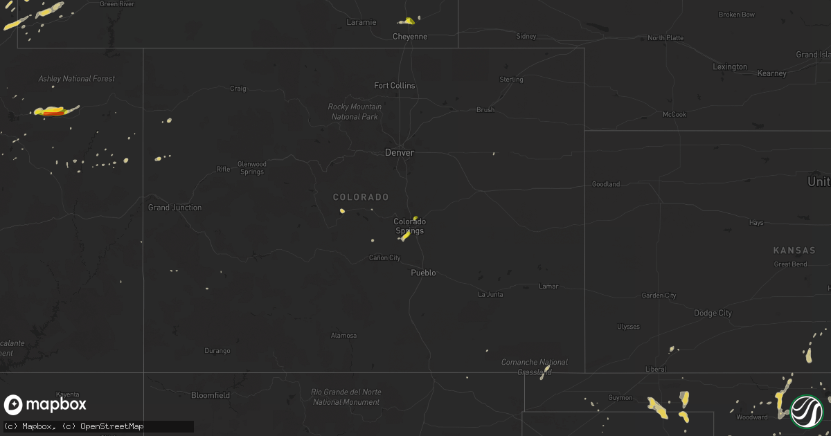
Hail Map on August 7, 2016
Get this storm
August 7 map
$229
one time, instant access
Download today. No call, no setup
Keep the $229
Bought the map and want the full workflow? Apply the entire $229 to a subscription within 7 days. None of it is wasted.
Every map, not just this one
This buys you this map. Subscription and you get every map we run, in the markets you choose from a few cities to whole states to nationwide. Plus real-time alerts the moment a storm fires.
Contact data
Name, contact info, occupancy, even credit band for addresses in the footprint. You go from where it hit to who to call.
Become the source they trust
Unlimited branding weather history reports on demand. You already have the documented answer ready for the property owner, and you are the one who showed up with it.
Property data and RoofTrace estimates
Pull up any address you have got, its value and the exact code rules for that jurisdiction, straight from One Click Code. Then RoofTrace estimates the squares, pitch, and roof value, priced the way you price.
States Impacted by Hail Map on August 7, 2016
Storm reports
Arkansas
| Date | Description |
|---|---|
| 08/07/20166:40 PM CDT | A large tree was blown over. |
| 08/07/20164:30 PM CDT | A few large tree limbs down along highway 365. |
| 08/07/20164:30 PM CDT | A large tree fell down. |
| 08/07/20163:45 PM CDT | A tree was blown over. |
| 08/07/20162:25 PM CDT | A few large trees reported down in the area. |
Texas
| Date | Description |
|---|---|
| 08/07/20164:06 PM CDT | A local report indicates 60 MPH wind near 10 ESE VALLEY DE ORO |
Utah
| Date | Description |
|---|---|
| 08/06/20167:35 PM CDT | A local report indicates 1.75 inch wind near 5 NNE DUCHESNE |
| 08/06/20167:05 PM CDT | A local report indicates 1.00 inch wind near 5 E FRUITLAND |
Wyoming
| Date | Description |
|---|---|
| 08/07/20166:52 PM CDT | A local report indicates 1.25 inch wind near 10 N CHEYENNE |
| 08/07/20166:43 PM CDT | A local report indicates 1.00 inch wind near 10 N CHEYENNE |
| 08/07/20166:35 PM CDT | A local report indicates 60 MPH wind near 2 S SHERIDAN |
| 08/07/20165:26 PM CDT | A local report indicates 61 MPH wind near LANDER |
| 08/07/201612:16 PM CDT | A local report indicates 1.00 inch wind near COLTER BAY VILLAGE |
| 08/06/201611:57 PM CDT | A local report indicates 1.50 inch wind near FORT LARAMIE |
| 08/06/201611:35 PM CDT | Windshield damage to vehicles relayed through law enforcement dispatch. |
| 08/06/20169:38 PM CDT | Trees downed along a 1/4 mile long path about 25-50 yards wide. |
| 08/06/20169:05 PM CDT | A local report indicates 1.00 inch wind near 4 ESE ROZET |
| 08/06/20168:55 PM CDT | Mobile home roof blown off...campers turned over... Power lines down |
| 08/06/20168:55 PM CDT | About a dozen homes sustained damage from gusty winds. |
Idaho
| Date | Description |
|---|---|
| 08/07/20166:15 PM CDT | . |
| 08/07/20166:10 PM CDT | Damage was reported with this storm. A few windshields were smashed in and a few cars had some body damage. |
South Carolina
| Date | Description |
|---|---|
| 08/07/20165:15 PM CDT | Tree snapped...large limbs down...and damage to a fence. |
| 08/07/20165:00 PM CDT | Roof off house on thompson rd near intersection with reedy creek rd. Power line down on house across the street. A few trees knocked down as well. |
Colorado
| Date | Description |
|---|---|
| 08/06/201611:47 PM CDT | Dublin and powers. |
Louisiana
| Date | Description |
|---|---|
| 08/06/20168:30 PM CDT | Shreveport nws warning coordination meteorologist reports numerous trees down near black bayou reservoir. |
North Carolina
| Date | Description |
|---|---|
| 08/07/20164:36 PM CDT | Trees fell and brought down power lines in the sugar hill community. Ditches were also seen overflowing due to heavy rain. |
| 08/07/20164:30 PM CDT | Trees down at various locations in the vicinity of old fort. Tree debris also littering the ground at one site. Time approximated from radar. |
Oklahoma
| Date | Description |
|---|---|
| 08/07/20166:29 PM CDT | A local report indicates 60 MPH wind near 1 S BRYANS CORNER |
| 08/07/20163:00 PM CDT | A local report indicates 60 MPH wind near ARNETT |
| 08/06/201611:30 PM CDT | A local report indicates 68 MPH wind near MEDFORD |
| 08/06/201610:10 PM CDT | 73 mph wind gust measured by oklahoma mesonet |
| 08/06/201610:05 PM CDT | 59 mph gust measured by oklahoma mesonet |
| 08/06/20168:55 PM CDT | 4 inch tree limbs snapped. |
Montana
| Date | Description |
|---|---|
| 08/07/20166:55 PM CDT | Nickel to half dollar size hail falling. |
| 08/07/20166:55 PM CDT | Spotter reports dime to quarter sized hail |
| 08/07/20166:50 PM CDT | 66 mph wind gust at the ginger raws. Time of event is estimated. |
| 08/07/20166:47 PM CDT | Still hailing at time of call. |
| 08/07/20166:35 PM CDT | Delayed report from aug 7. |
| 08/07/20166:15 PM CDT | Small branches down due to gusty winds. |
| 08/07/20166:15 PM CDT | A local report indicates 59 MPH wind near 8 SSE WYOLA |
| 08/07/20166:15 PM CDT | 62 mph wind gust at the elkhorn raws location. Time of event is estimated. |
| 08/07/20165:45 PM CDT | Estimated quarter size hail falling. |
| 08/07/20165:32 PM CDT | 58 mph wind gust at homestake pass on interstate 90. |
| 08/07/20165:06 PM CDT | After lightning stopped... Spotter measured hail up to 1.25 inches in diameter. This supersedes the previous report of estimated 1 inch hail for this location. |
| 08/07/20164:40 PM CDT | Ping pong size hail falling. |
| 08/07/20164:25 PM CDT | Estimated quarter size hail in the clancy area. |
| 08/06/201610:22 PM CDT | Lindsay divide mt-dot mesonet station recorded a wind gust to 62 mph. |
| 08/06/20169:50 PM CDT | Storm spotter reports quarter sized hail |
| 08/06/20168:45 PM CDT | Quarter sized hail reported just west of sunburst. Time estimated based on radar. |
| 08/06/20168:30 PM CDT | Hail up to quarter size falling. Hail a few inches deep in places. Wind gusts estimated around 50 mph. |
| 08/06/20168:25 PM CDT | Golf ball size hail falling near sunburst. |
| 08/06/20168:11 PM CDT | A local report indicates 63 MPH wind near 23 ENE COLSTRIP |
| 08/06/20167:34 PM CDT | A local report indicates 60 MPH wind near 9 ESE BIRNEY |
| 08/06/20167:00 PM CDT | Hail ranged from pea sized to larger than a quarter |
Cities Impacted by Hail Map on August 7, 2016
- Soda Springs, ID
- Arnett, OK
- Forgan, OK
- Naples, TX
- Boise City, OK
- Richmond, UT
- Franklin, ID
- Lewiston, UT
- Wister, OK
- Moose, WY
- Woodruff, UT
- Townsend, MT
- Aladdin, WY
- Neihart, MT
- Hobson, MT
- Stanford, MT
- Jennings, LA
- Winston, MT
- Douglas, WY
- Gillette, WY
- Fairplay, CO
- Zenda, KS
- Mena, AR
- Talmage, UT
- White Sulphur Springs, MT
- Wayan, ID
- Cheyenne, WY
- Guernsey, WY
- Yoder, WY
- Jay Em, WY
- Fort Laramie, WY
- Wellington, KS
- Oxford, KS
- Chickamauga, GA
- Eden, UT
- Clancy, MT
- Basin, MT
- Butte, MT
- Warm Springs, MT
- Jefferson City, MT
- Helena, MT
- Boulder, MT
- East Helena, MT
- Hartville, WY
- Glendo, WY
- Wolf Point, MT
- Boles, AR
- Booker, TX
- Ames, OK
- Nash, OK
- Huntington, AR
- Hackett, AR
- Greenwood, AR
- Salmon, ID
- Mountain Home, UT
- Balko, OK
- Hardesty, OK
- Rock Hill, SC
- Wheatland, WY
- Lingle, WY
- Altamont, UT
- Duchesne, UT
- Beaver, OK
- Benton, LA
- Montpelier, ID
- Paris, ID
- Evanston, WY
- Cokeville, WY
- Lodge Grass, MT
- Whitehall, MT
- Rigby, ID
- Idaho Falls, ID
- Rexburg, ID
- Spearman, TX
- Alpine, WY
- Etna, WY
- Waynoka, OK
- Tellico Plains, TN
- Decker, MT
- Erath, LA
- Haughton, LA
- Bossier City, LA
- Jeanerette, LA
- Parkman, WY
- Dayton, WY
- Wyola, MT
- Carmen, ID
- Rozet, WY
- Geyser, MT
- Gray Court, SC
- Fountain Inn, SC
- Preston, ID
- Winnfield, LA
- Monarch, MT
- Roosevelt, UT
- Sunburst, MT
- Lusk, WY
- Egan, LA
- Crowley, LA
- Colorado Springs, CO
- Divide, MT
- Weston, WY
- Hulett, WY
- Moorcroft, WY
- Upton, WY
- Nordman, ID
- Conway Springs, KS
- Sunray, TX
- Otter, MT
- Dingle, ID
- Mayfield, KS
- Newcastle, WY
- Ellis, ID
- Alva, OK
- Fargo, OK
- Raynesford, MT
- Panama City Beach, FL
- Alta, WY
- Eagletown, OK
- Valliant, OK
- Ringold, OK
- Rattan, OK
- Watonga, OK
- Sheridan, WY
- Banner, WY
- Clearmont, WY
- Smithville, OK
- Watson, OK
- Rangely, CO
- Perryton, TX
- Homer, LA
- Athens, LA
- Hooker, OK
- Rock, KS
- Whitesboro, OK
- Carrier, OK
- Enid, OK
- Canon City, CO
- Anaconda, MT
- Okeene, OK
- Kevin, MT
- Honobia, OK
- Talihina, OK
- Bancroft, ID
- Plains, KS
- Toston, MT
- East Carbon, UT
- Mooreland, OK
- Stinnett, TX
- Edgemont, SD
- Arcadia, LA
- Gibsland, LA
- Foreman, AR
- Winthrop, AR
- Garrett, WY
- Abbeville, LA
- Ruston, LA
- Iota, LA
- Cut Bank, MT
- Sweet Grass, MT
- Lithonia, GA
- Conyers, GA
- Canadian, TX
- Fort Supply, OK
- Sedan, KS
- Ashford, AL
- Longdale, OK
- Canton, OK
- Hitchcock, OK
- Isabella, OK
- Southard, OK
- Birney, MT
- De Beque, CO
- Oral, SD
- Garden Plain, KS
- Montrose, CO
- Dodson, LA
- Gueydan, LA
- Lake Arthur, LA
- Rayne, LA
- Church Point, LA
- Catawba, SC
- Sharon, KS
- Medicine Lodge, KS
- Woodward, OK
- Kaplan, LA
- Duson, LA
- Wolf, WY
- Lahoma, OK
- Franklin, LA
- Fort Payne, AL
- Chester, OK
- Galata, MT
- Simpsonville, SC
- Oilmont, MT
- Haworth, OK
- Kingman, KS
- Dubach, LA
- Trout, LA
- Hazelton, KS
- Lancaster, SC
- Kemmerer, WY
- Linden, TX
- Briscoe, TX
- Lake Charles, LA
- Fairview, UT
- Grace, ID
- Torrington, WY
- Florissant, CO
- Viola, KS
- Sikes, LA
- Hermitage, AR
- Lima, MT
- Ririe, ID
- Jet, OK
- Zachary, LA
- Malone, FL
- Marianna, FL
- Nucla, CO
- North Fork, ID
- Logan, UT
- Swan Valley, ID
- Cody, WY
- Pond Creek, OK
- Kremlin, OK
- Omaha, TX
- Irwin, ID
- Cleo Springs, OK
- Cerrillos, NM
- Doddridge, AR
- Leadore, ID
- Westville, FL
- Geneva, AL
- Thomas, OK
- Madisonville, TN
- Vonore, TN
- Shreveport, LA
- Mutual, OK
- Valley Head, AL
- Shawnee, WY
- Medford, OK
- Nashville, KS
- Fruitland, UT
- Big Horn, WY
- Quitman, LA
- Jonesboro, LA
- Collinsville, AL
- Lyman, WY
- Fort Bridger, WY
- Lake George, CO
- Plain Dealing, LA
- Bell City, LA
- Wise River, MT