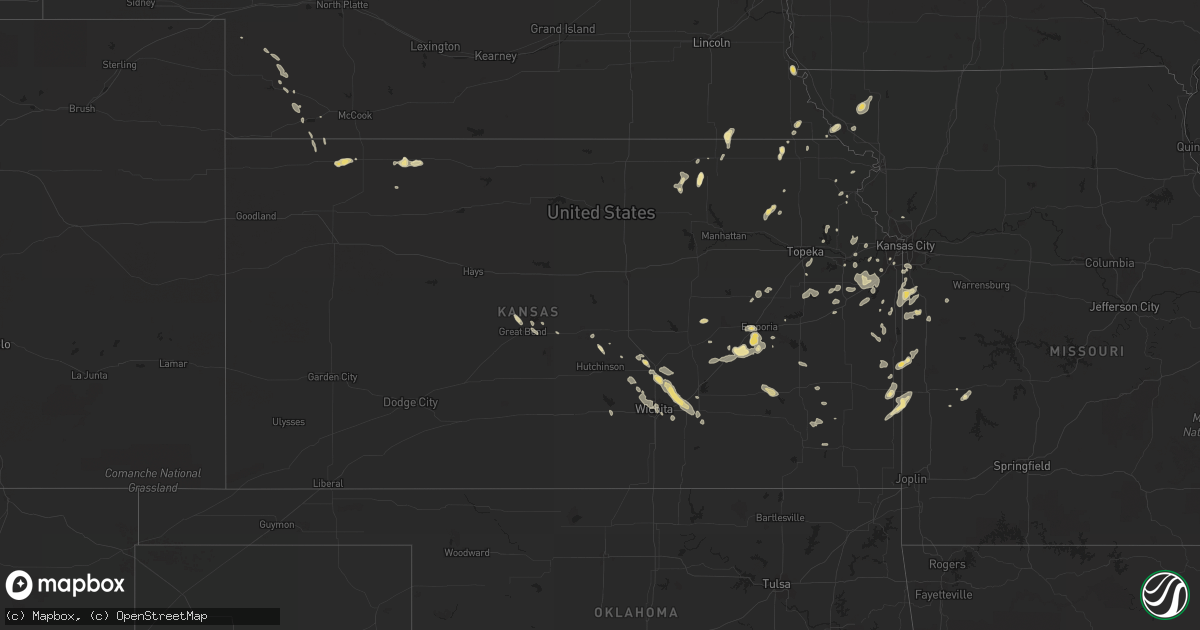
Hail Map in Kansas on August 6, 2014
Get this storm
August 6 map
$229
one time, instant access
Download today. No call, no setup
Keep the $229
Bought the map and want the full workflow? Apply the entire $229 to a subscription within 7 days. None of it is wasted.
Every map, not just this one
This buys you this map. Subscription and you get every map we run, in the markets you choose from a few cities to whole states to nationwide. Plus real-time alerts the moment a storm fires.
Contact data
Name, contact info, occupancy, even credit band for addresses in the footprint. You go from where it hit to who to call.
Become the source they trust
Unlimited branding weather history reports on demand. You already have the documented answer ready for the property owner, and you are the one who showed up with it.
Property data and RoofTrace estimates
Pull up any address you have got, its value and the exact code rules for that jurisdiction, straight from One Click Code. Then RoofTrace estimates the squares, pitch, and roof value, priced the way you price.
Storm reports in Kansas
Kansas
| Date | Description |
|---|---|
| 08/06/20143:01 PM CDT | Estimated 60 mph winds with pea size hail. Power went out. |
| 08/06/20142:13 PM CDT | 6 to 12 inch diameter tree limbs down between road 70 and road 100...6 to 8 miles east of olpe. 12inch limbs were from dead trees. Old barn had 2 tin roof panels blown |
| 08/06/201412:05 PM CDT | Estimated 65-70 mph near douglas and oliver. |
| 08/06/201412:05 PM CDT | A local report indicates 60 MPH wind near 3 NNE DOUGLASS |
| 08/06/20141:57 AM CDT | A local report indicates 59 MPH wind near WELLINGTON |
| 08/06/20141:05 AM CDT | Time estimated |
| 08/06/201412:40 AM CDT | Time estimated |
| 08/06/201412:40 AM CDT | Large tree was broken off at the base. Tree diameter was 17 inches. Tree was dying and appears to have a hollowed out portion of the trunk via picture on twitter. |
| 08/06/201412:40 AM CDT | A local report indicates 60 MPH wind near 3 NNE DOUGLASS |
| 08/06/201412:30 AM CDT | Tree fell on a house near hillside and pawnee. Time is estimated. |
| 08/06/201412:25 AM CDT | A local report indicates 71 MPH wind near MCCONNELL AFB |
| 08/06/201412:05 AM CDT | Estimated 65-70 mph near douglas and oliver. |
| 08/05/201411:45 PM CDT | Trailer blown over and destroyed. Source kake tv. |
| 08/05/201411:45 PM CDT | Trailer blown over and destroyed. Source kake tv. |
| 08/05/201411:06 PM CDT | Many large tree branches down across the north side of augusta. |
| 08/05/201410:38 PM CDT | 6 to 7 foot tree with a 6 inch diameter snapped due to winds. A full garbage can blown 75 yards down the street. Power is out between benton and the briar cliff additio |
| 08/05/201410:38 PM CDT | Report via twitter. |
| 08/05/20148:15 PM CDT | Treeds blown down. Relayed via wibw tv. |
| 08/05/20148:03 PM CDT | A local report indicates 69 MPH wind near EMPORIA AIRPORT |
All States Impacted by Hail Map on August 6, 2014
Cities Impacted by Hail Map on August 6, 2014
- Lenexa, KS
- Newton, KS
- Halstead, KS
- Van Buren, MO
- Emporia, KS
- Villa Ridge, MO
- Franklin, VA
- Windsor, VA
- Carrsville, VA
- Zuni, VA
- Wendover, UT
- Virgil, KS
- Neal, KS
- Toronto, KS
- Eureka, KS
- Barnes, KS
- Tooele, UT
- Linn, KS
- Greenleaf, KS
- Poplar Bluff, MO
- Rantoul, KS
- Wellsville, KS
- Paola, KS
- Norcatur, KS
- Norton, KS
- Blackfoot, ID
- Firth, ID
- Wymore, NE
- Liberty, NE
- Great Bend, KS
- Hoisington, KS
- Olpe, KS
- Matfield Green, KS
- Skidmore, MO
- Marble Hill, MO
- Zalma, MO
- Sullivan, MO
- Bourbon, MO
- Craig, MO
- Salt Lake City, UT
- West Valley City, UT
- Glenallen, MO
- Patton, MO
- Fort Scott, KS
- Highland, NY
- Crook, CO
- El Dorado Springs, MO
- Atwood, KS
- Cummings, KS
- Bloomfield, MO
- Iona, ID
- Berryton, KS
- Herndon, KS
- Oberlin, KS
- Atchison, KS
- Spring Creek, NV
- Allen, KS
- Lewiston, ME
- Eudora, KS
- Soldier, KS
- Onaga, KS
- Havensville, KS
- Emmett, KS
- Strong City, KS
- Gray Summit, MO
- Kiln, MS
- Lowman, ID
- Rush Valley, UT
- Stockton, UT
- Dawson, NE
- Verdon, NE
- Rulo, NE
- Thayer, KS
- Dennis, KS
- Crawfordville, FL
- Lyons, KS
- Greenville, MO
- Lowndes, MO
- Wappapello, MO
- North Loup, NE
- Scotia, NE
- Cleveland, MO
- Paxton, NE
- Keystone, NE
- Oneida, KS
- Inman, KS
- Palisade, NE
- Arcadia, KS
- Bronaugh, MO
- Garland, KS
- Deerfield, MO
- Union, MO
- Lucedale, MS
- Wilmer, AL
- Stockton, MO
- Hartford, KS
- Gardner, KS
- Edgerton, KS
- Patterson, MO
- Wichita, KS
- Sabetha, KS
- Lebo, KS
- Bern, KS
- Ellinwood, KS
- Derby, KS
- Rose Hill, KS
- Ottawa, KS
- Williamsburg, KS
- Princeton, KS
- Ozawkie, KS
- Garden City, MO
- Oketo, KS
- Grandview, MO
- Kansas City, MO
- Fort Morgan, CO
- Overland Park, KS
- Sheldon, MO
- Madison, KS
- Mcconnell Afb, KS
- Bonner Springs, KS
- Linwood, KS
- De Soto, KS
- Foster, MO
- Hume, MO
- Prescott, KS
- Adrian, MO
- Archie, MO
- Drexel, MO
- Hammond, LA
- Ponchatoula, LA
- Springfield, LA
- Orlando, FL
- Maitland, MO
- Graham, MO
- Peculiar, MO
- Medina, TN
- Brush, CO
- Sedgwick, KS
- Grandin, MO
- Harviell, MO
- Oskaloosa, KS
- Stratton, NE
- Wauneta, NE
- Towanda, KS
- Benton, KS
- Augusta, KS
- Andover, KS
- Whitewater, KS
- Valley Center, KS
- El Dorado, KS
- Cedar Point, KS
- Maize, KS
- North Salem, NY
- Brewster, NY
- Ridgefield, CT
- Holcomb, MO
- Campbell, MO
- Maurertown, VA
- Bragg City, MO
- Peru, NE
- Nebraska City, NE
- Chase, KS
- Raymond, KS
- Green River, WY
- Doniphan, MO
- Waterville, KS
- La Cygne, KS
- Parker, KS
- Tonganoxie, KS
- Maryville, MO
- Labadie, MO
- Pacific, MO
- Chesterfield, MO
- Wildwood, MO
- Robertsville, MO
- Saint Charles, MO
- Saint Albans, MO
- Olathe, KS
- Sturdivant, MO
- Advance, MO
- Council Grove, KS
- Piggott, AR
- Kennett, MO
- Greenway, AR
- Marysville, KS
- Hanover, KS
- Tillson, NY
- Rosendale, NY
- New Paltz, NY
- Saint Clair, MO
- Home, KS
- Burchard, NE
- Milan, TN
- Jackson, TN
- Oakfield, TN
- New Gloucester, ME
- Cottonwood Falls, KS
- Circleville, KS
- Rich Hill, MO
- Fulton, KS
- Clubb, MO
- Okeechobee, FL
- Burrton, KS
- Puxico, MO
- Enders, NE
- Belton, MO
- Louisburg, KS
- Freeman, MO
- Bucyrus, KS
- Palmer, KS
- Piqua, KS
- Meriden, KS
- Green, KS
- Salem, NE
- Lawrence, KS
- Winter Springs, FL
- Clayton, KS
- Delia, KS
- Leon, KS
- Auburn, ME
- Kissimmee, FL
- Lisbon, ME
- Smithville, MO
- Washington, MO
- Olmitz, KS
- Seneca, KS
- Baldwin City, KS
- Spring Hill, KS
- New Century, KS
- Le Roy, KS
- Trenton, NE
- Cheney, KS
- Carbondale, KS
- Chanute, KS
- Humboldt, KS
- Bayard, NE
- Hiawatha, KS
- Denmark, TN
- Bells, TN
- Farlington, KS
- Vassar, KS
- Scranton, KS
- Quenemo, KS
- Lyndon, KS
- Overbrook, KS
- Osage City, KS
- Tickfaw, LA
- Blue Mound, KS
- Mound City, KS
- Dyersburg, TN
- Newbern, TN
- Marquand, MO
- Marston, MO
- Amite, LA
- Lancaster, KS
- Venango, NE
- Ivor, VA
- Suffolk, VA
- Butler, MO
- Pomona, KS
- Atlanta, KS
- Piedmont, MO
- Ellington, MO
- Hesston, KS
- Moundridge, KS
- Fontana, KS
- Oregon, MO
- Mound City, MO
- Bendena, KS
- Troy, KS
- McLouth, KS
- Greene, ME
- Buhler, KS
- Benedict, KS
- Altoona, KS
- Madrid, NE
- Biloxi, MS
- Saucier, MS
- Eureka, NV
- Shawnee, KS
- Minot, ME
- Wappingers Falls, NY
- Poughkeepsie, NY


