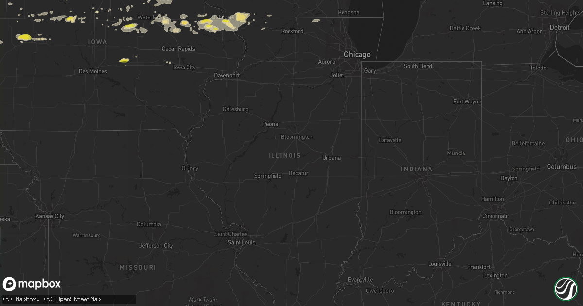
Hail Map in Illinois on August 5, 2018
Get this storm
August 5 map
$229
one time, instant access
Download today. No call, no setup
Keep the $229
Bought the map and want the full workflow? Apply the entire $229 to a subscription within 7 days. None of it is wasted.
Every map, not just this one
This buys you this map. Subscription and you get every map we run, in the markets you choose from a few cities to whole states to nationwide. Plus real-time alerts the moment a storm fires.
Contact data
Name, contact info, occupancy, even credit band for addresses in the footprint. You go from where it hit to who to call.
Become the source they trust
Unlimited branding weather history reports on demand. You already have the documented answer ready for the property owner, and you are the one who showed up with it.
Property data and RoofTrace estimates
Pull up any address you have got, its value and the exact code rules for that jurisdiction, straight from One Click Code. Then RoofTrace estimates the squares, pitch, and roof value, priced the way you price.
Storm reports in Illinois
Illinois
| Date | Description |
|---|---|
| 08/05/20186:55 PM CDT | Tree blown down on portion of highway 84 just southeast of hanover. |
| 08/05/20182:12 AM CDT | At 712 PM CDT, a severe thunderstorm was located near Warren, or 11 miles southeast of Darlington, moving east at 20 mph. HAZARD...60 mph wind gusts and quarter size hail. SOURCE...Radar indicated. IMPACT...Hail damage to vehicles is expected. Expect wind damage to roofs, siding, and trees. Locations impacted include... Monroe, Monticello, Argyle, Somers, Wiota, South Wayne, Browntown, Gratiot, Juda, Woodford and Jordan Center. |
| 08/04/20187:40 PM CDT | Measured wind gust of 51 kts. |
| 08/04/20187:38 PM CDT | Isolated tree & power line damage in freeport. Roof partially torn off metal warehouse sw of town. Time estimated by radar. |
| 08/04/20187:25 PM CDT | Roof blown off structure in shannon. Trees and limbs down across the northern half of the county... Blocking some roads in rural areas. Time estimated from radar. |
| 08/04/20187:00 PM CDT | Trees reported down on southeast side of elizabeth. |
All States Impacted by Hail Map on August 5, 2018
Cities Impacted by Hail Map on August 5, 2018
- Saint Petersburg, FL
- Folsom, NM
- Grundy Center, IA
- Clancy, MT
- La Motte, IA
- East Dubuque, IL
- Galena, IL
- Bellevue, IA
- Dubuque, IA
- Wamsutter, WY
- Scales Mound, IL
- Pelkie, MI
- Nisula, MI
- Rockland, MI
- Republic, MI
- Covington, MI
- Michigamme, MI
- Ontonagon, MI
- Mass City, MI
- Three Forks, MT
- Bagley, WI
- Stamford, NE
- Rushville, NE
- Ellsworth, NE
- Hay Springs, NE
- Sterling, CO
- Iliff, CO
- Ravenden, AR
- Stockton, IL
- Fleming, CO
- Larkspur, CO
- Peyton, CO
- Elbert, CO
- Rawlins, WY
- Yuma, CO
- Haxtun, CO
- Holyoke, CO
- Wray, CO
- Padroni, CO
- Hanna, WY
- Cheyenne, WY
- Elk Mountain, WY
- Bosler, WY
- Rock River, WY
- Laramie, WY
- Ute, IA
- Onawa, IA
- Castana, IA
- Soldier, IA
- Mapleton, IA
- Colby, KS
- Fort Dodge, IA
- Waverly, IA
- Williams, IA
- Trinchera, CO
- Trinidad, CO
- Reinbeck, IA
- Scotia, NE
- Oakdale, PA
- Bridgeville, PA
- Pittsburgh, PA
- Homestead, IA
- Farley, IA
- Bernard, IA
- Cascade, IA
- Lewellen, NE
- Mason City, NE
- Benton, WI
- Apple River, IL
- Shullsburg, WI
- North Bend, NE
- Alexander, ND
- North Loup, NE
- Ord, NE
- Walsenburg, CO
- Kellogg, IA
- Newton, IA
- Grinnell, IA
- Ishpeming, MI
- Wellsburg, IA
- Steamboat Rock, IA
- Eldora, IA
- Limon, CO
- Ryan, IA
- Manchester, IA
- Masonville, IA
- Morrison, IA
- Conrad, IA
- Raton, NM
- Ovid, CO
- Sedgwick, CO
- Hayes Center, NE
- Millboro, VA
- Saint Edward, NE
- Albion, NE
- New Vienna, IA
- Earlville, IA
- Dyersville, IA
- Delhi, IA
- Hopkinton, IA
- Winthrop, IA
- Lemoyne, NE
- Arthur, NE
- Oakley, KS
- Scott City, KS
- Williston, ND
- Duncombe, IA
- Otho, IA
- Lexington, MS
- Marienthal, KS
- Leoti, KS
- Lutsen, MN
- Maywood, NE
- Laguna, NM
- Worthington, IA
- San Simon, AZ
- Dows, IA
- Linwood, NE
- Morse Bluff, NE
- Prague, NE
- Rock Springs, WY
- Batesland, SD
- Dunkerton, IA
- Scribner, NE
- Brockton, MT
- Phillips, WI
- Fifield, WI
- Park Falls, WI
- Winter, WI
- Butternut, WI
- Chambers, NE
- Ackley, IA
- Gove, KS
- Grainfield, KS
- Grinnell, KS
- Vail, IA
- Westside, IA
- Kimball, NE
- Bushnell, NE
- Lehigh, IA
- Webster City, IA
- Moorland, IA
- Sumter, SC
- Alden, IA
- Lugoff, SC
- Eastover, SC
- New Raymer, CO
- Oberlin, KS
- Jesup, IA
- Independence, IA
- Rowley, IA
- Brandon, IA
- Natrona Heights, PA
- Sarver, PA
- Freeport, PA
- Paducah, KY
- Brookport, IL
- Metropolis, IL
- Randolph, NE
- Bingham, NE
- Winona, KS
- Rexford, KS
- Aurelia, IA
- Cherokee, IA
- Eben Junction, MI
- Rock, MI
- Skandia, MI
- Chatham, MI
- Trenary, MI
- Rumely, MI
- Arcadia, IA
- Kiron, IA
- Denison, IA
- Deloit, IA
- Breda, IA
- Bainville, MT
- Fairview, MT
- Parkersburg, IA
- Woolstock, IA
- Wetmore, CO
- Chadron, NE
- Pine Ridge, SD
- Oelwein, IA
- Maynard, IA
- Coggon, IA
- Walker, IA
- Bentonia, MS
- Sidney, NE
- Rye, CO
- Westcliffe, CO
- Santa Rosa Beach, FL
- Saint Olaf, IA
- Garnavillo, IA
- Elkader, IA
- Oshkosh, NE
- Linden, TN
- Elba, NE
- Wolbach, NE
- Lanse, MI
- Branson, CO
- Hazelhurst, WI
- Tomahawk, WI
- Tripoli, WI
- Harshaw, WI
- Allison, IA
- Crook, CO
- Peetz, CO
- Decatur, NE
- Charter Oak, IA
- Huachuca City, AZ
- Goodland, KS
- Edson, KS
- Pine Bluffs, WY
- Douglas, WY
- Glenrock, WY
- Negaunee, MI
- Amherst, CO
- Ireton, IA
- Fayette, IA
- Scottsville, KY
- Beaman, IA
- Rutland, IA
- Bradgate, IA
- Warren, IL
- Nora, IL
- Leechburg, PA
- Phillipsburg, KS
- Long Island, KS
- Aguilar, CO
- South Wayne, WI
- Hampton, IA
- Iowa Falls, IA
- Quinter, KS
- Park, KS
- Fonda, IA
- Pomeroy, IA
- Palmer, IA
- Columbia, SC
- Hooper, NE
- Epworth, IA
- Zwingle, IA
- Hudson, IA
- Buckingham, IA
- Traer, IA
- Glidden, IA
- Carroll, IA
- Lidderdale, IA
- Saint Johns, AZ
- Cedar Rapids, NE
- Nashville, NC
- Rocky Mount, NC
- Rembert, SC
- Wounded Knee, SD
- Dundee, IA
- Gardner, CO
- Union, IA
- Medina, TN
- Jackson, TN
- Oakfield, TN
- Howells, NE
- Dodge, NE
- Wisner, NE
- Potter, NE
- Dix, NE
- Julesburg, CO
- Saratoga, WY
- Manson, IA
- West Point, NE
- Gratiot, WI
- Cuba City, WI
- Hazel Green, WI
- Bruno, NE
- Bristow, IA
- Dumont, IA
- Monticello, IA
- Oconto, NE
- Lexington, NE
- Duluth, MN
- Brimson, MN
- Harvard, IL
- Alliance, NE
- South Amana, IA
- Clyo, GA
- Tampa, FL
- Dike, IA
- Holland, IA
- Wagener, SC
- Churdan, IA
- Scranton, IA
- Westgate, IA
- Fairbank, IA
- Sumner, IA
- Genoa, CO
- Tierra Amarilla, NM
- Rapid River, MI
- Amelia, NE
- Orange City, IA
- Elizabeth, IL
- Peosta, IA
- Durango, IA
- Hanover, IL
- Savanna, IL
- Aiken, SC
- Badger, IA
- Vincent, IA
- Bethel Park, PA
- Finleyville, PA
- South Park, PA
- Venetia, PA
- Canonsburg, PA
- Cubero, NM
- Beulah, CO
- Ramah, CO
- Schaller, IA
- Vesuvius, VA
- Beemer, NE
- Bruce Crossing, MI
- Litchfield, NE
- Casper, WY
- Humboldt, IA
- Drasco, AR
- Burns, WY
- Poplar, MT
- Lytton, IA
- Jolley, IA
- Sac City, IA
- Nemaha, IA
- Oglala, SD
- Stanley, NM
- Hubbard, IA
- Rockbridge Baths, VA
- Woodworth, ND
- Grand Marais, MN
- Barnum, IA
- Bellaire, OH
- Cedar Hill, TN
- Munising, MI
- Model, CO
- Rockwell City, IA
- Lake City, IA
- Auburn, IA
- Ravenden Springs, AR
- Somers, IA
- Knierim, IA
- Freeport, IL
- Tribune, KS
- Storm Lake, IA
- Vinton, IA
- Quasqueton, IA
- La Porte City, IA
- Center Point, IA
- Waterloo, IA
- Gilbertville, IA
- Aplington, IA
- Lexington, VA
- Juda, WI
- Monroe, WI
- Shell Rock, IA
- Clarksville, IA
- Pearl City, IL
- Manville, WY
- Oran, IA
- Readlyn, IA
- Tripoli, IA
- Moffat, CO
- Maurice, IA
- Gladbrook, IA
- Ulysses, KS
- Rhinelander, WI
- Stuart, NE
- Atkinson, NE
- North Versailles, PA
- Newell, IA
- Chassell, MI


