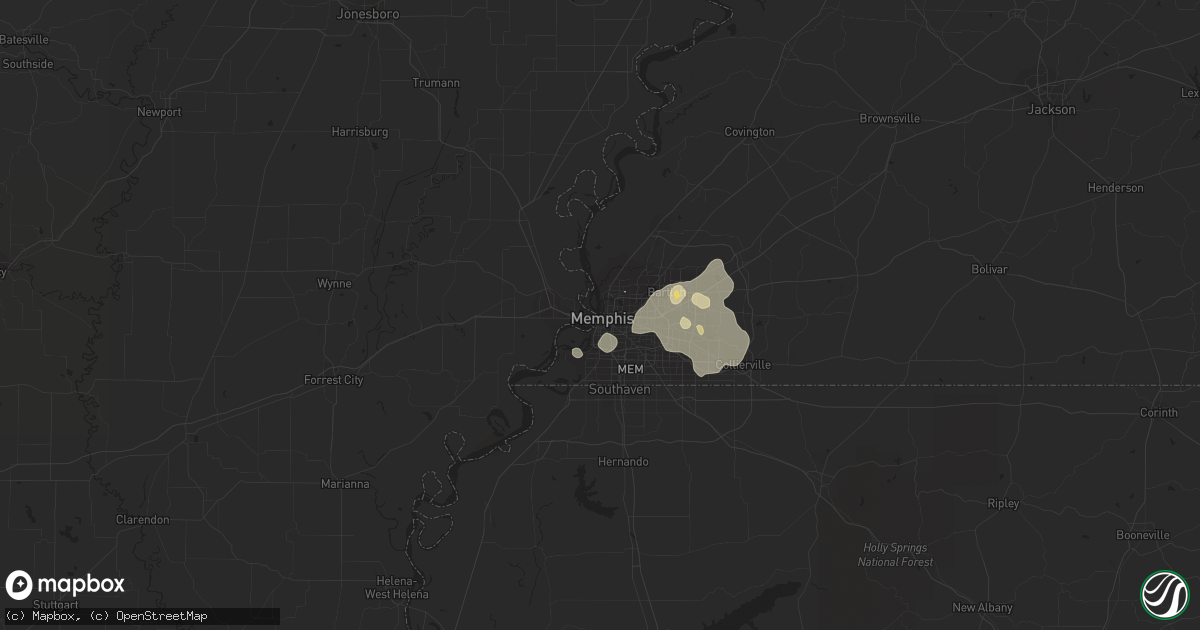
Hail Map in Memphis, TN on August 5, 2015
Get this storm
August 5 map
$229
one time, instant access
Download today. No call, no setup
Keep the $229
Bought the map and want the full workflow? Apply the entire $229 to a subscription within 7 days. None of it is wasted.
Every map, not just this one
This buys you this map. Subscription and you get every map we run, in the markets you choose from a few cities to whole states to nationwide. Plus real-time alerts the moment a storm fires.
Contact data
Name, contact info, occupancy, even credit band for addresses in the footprint. You go from where it hit to who to call.
Become the source they trust
Unlimited branding weather history reports on demand. You already have the documented answer ready for the property owner, and you are the one who showed up with it.
Property data and RoofTrace estimates
Pull up any address you have got, its value and the exact code rules for that jurisdiction, straight from One Click Code. Then RoofTrace estimates the squares, pitch, and roof value, priced the way you price.
Storm reports in Memphis, TN
Memphis, TN
| Date | Description |
|---|---|
| 08/05/20155:00 PM CDT | Power lines down near crestview at bartlett road. |
| 08/05/20154:55 PM CDT | Large tree down near white station and gwynne. |
| 08/05/20154:45 PM CDT | Large tree down. |
| 08/05/20154:45 PM CDT | Large tree down at belle meade blocking roadway. |
| 08/05/20154:00 PM CDT | Trees down along brother blvd. |
All States Impacted by Hail Map on August 5, 2015
All Cities Impacted by Hail Map on August 5, 2015
- Blackfoot, ID
- Sidney, AR
- Cave City, AR
- Reed Point, MT
- Littlefield, TX
- Edgemont, SD
- Plymouth, UT
- Garland, UT
- Fielding, UT
- Bradford, AR
- Newport, AR
- Snowville, UT
- Lascassas, TN
- Grouse Creek, UT
- Park Valley, UT
- Centerville, TN
- Augusta, AR
- McCrory, AR
- Hindsville, AR
- Witter, AR
- Pettigrew, AR
- Huntsville, AR
- Combs, AR
- Ozone, AR
- Wesley, AR
- Saint Paul, AR
- Elkins, AR
- Oark, AR
- Cabot, AR
- Jacksonville, AR
- Vilonia, AR
- McLeod, MT
- Plainview, AR
- Wellford, SC
- Lyman, SC
- Inman, SC
- Hale Center, TX
- Heber Springs, AR
- Columbia, SD
- Aberdeen, SD
- Westport, SD
- Michie, TN
- Corinth, MS
- Leslie, AR
- Monterey, TN
- Crawford, TN
- Lebanon, TN
- Roland, OK
- Muldrow, OK
- Kingman, KS
- Waynesburg, KY
- Crab Orchard, KY
- Ozark, AR
- Fort Smith, AR
- Iliff, CO
- Peetz, CO
- Morrison, TN
- Bradyville, TN
- Woodbury, TN
- Pangburn, AR
- Bath, SD
- Readyville, TN
- Murfreesboro, TN
- Milton, TN
- Memphis, TN
- Holbrook, ID
- Valentine, NE
- Morrilton, AR
- Perry, AR
- Fairburn, SD
- Williamsport, TN
- Columbia, TN
- Oelrichs, SD
- Smithwick, SD
- Davisboro, GA
- Bartow, GA
- Tuthill, SD
- Dardanelle, AR
- Russellville, AR
- Locust Grove, AR
- Batesville, AR
- Plainview, TX
- Hackett, AR
- Greenwood, AR
- Cherry Valley, AR
- Brinkley, AR
- Monticello, KY
- Frederick, SD
- Barnard, SD
- Leola, SD
- Groton, SD
- Sallisaw, OK
- Moro, AR
- Palestine, AR
- Ellsworth, ME
- Clarksville, AR
- Lonoke, AR
- Guthrie, OK
- Jones, OK
- Edmond, OK
- Luther, OK
- Arcadia, OK
- Lamar, AR
- Firth, ID
- Shelley, ID
- Metropolis, IL
- Paducah, KY
- Brookport, IL
- Howell, UT
- Idaho Falls, ID
- Boaz, KY
- Bangor, ME
- Edmonton, KY
- Spring Hill, TN
- McRae, AR
- Bronston, KY
- Watertown, TN
- Stigler, OK
- Buckatunna, MS
- Pocola, OK
- Selby, SD
- Upham, ND
- Aberdeen, ID
- American Falls, ID
- Alma, AR
- Rudy, AR
- Eddington, ME
- Carlisle, AR
- Whitney, NE
- Crawford, NE
- Oil Trough, AR
- Thida, AR
- Oklahoma City, OK
- Lexington, NC
- Clemmons, NC
- Calvin, KY
- Pineville, KY
- Covington, TN
- Melbourne, AR
- Merriman, NE
- Gordon, NE
- Tetonia, ID
- Felt, ID
- Mount Judea, AR
- Iona, ID
- Ririe, ID
- Rushville, NE
- Amherst, TX
- Scooba, MS
- Hardy, AR
- Ash Flat, AR
- Cherokee Village, AR
- Williford, AR
- Duck River, TN
- Tremonton, UT
- Pleasant Plains, AR
- Spiro, OK
- Keota, OK
- Water Valley, MS
- Randolph, MS
- Bruce, MS
- Banner, MS
- Webster, SD
- Mountain View, AR
- Mount Pleasant, AR
- Guion, AR
- Santa Fe, TN
- Coal Hill, AR
- Floral, AR
- Springdale, AR
- Parthenon, AR
- Deer, AR
- Vendor, AR
- Ewing, VA
- Harrogate, TN
- Pottsville, AR
- Wynne, AR
- Dover, AR
- Porum, OK
- Whitefield, OK
- Montello, NV
- Middleton, TN
- Pocahontas, TN
- Bethel Springs, TN
- Hornsby, TN
- Selmer, TN
- Kingston, AR
- Cotton Plant, AR
- Hunter, AR
- Byhalia, MS
- Alexander, AR
- Effingham, SC
- Florence, SC
- Moose, WY
- New Blaine, AR
- Delaware, AR
- Conway, AR
- Arlington, TN
- Wilburn, AR
- Mason, TN
- Arkansas City, KS
- Bradley, ME
- Brewer, ME
- Orono, ME
- Naples, FL
- Millry, AL
- Gainesboro, TN
- Bokoshe, OK
- Casa, AR
- Russell, AR
- Bald Knob, AR
- Lavaca, AR
- Clarkton, NC
- Coffeeville, MS
- Winfield, TN
- Newport, TN
- Newark, AR
- Chadron, NE
- Piedmont, OK
- Lucedale, MS
- Gans, OK
- Shady Point, OK
- Arkoma, OK
- Cameron, OK
- Van Buren, AR
- Barling, AR
- Langford, SD
- Cosby, TN
- Erwin, TN
- Hickory Ridge, AR
- Fayette, AL
- Malad City, ID
- Paris, MS
- Helena, AR
- Lexa, AR
- Stilwell, OK
- Pelsor, AR
- Hector, AR
- Fayetteville, AR
- Uniontown, AR
- Red Banks, MS
- Holly Springs, MS
- Crossville, TN
- Anton, TX
- Malta, ID
- Burkesville, KY
- Auburntown, TN
- Liberty, TN
- London, AR
- Joiner, AR
- Frenchmans Bayou, AR
- Bassett, AR
- Cordova, TN
- Hay Springs, NE
- Horseshoe Bend, AR
- Franklin, AR
- Evening Shade, AR
- Clifton, TN
- Spencer, OK
- Jonesborough, TN
- Johnson City, TN
- Cherryfield, ME
- Harrison, NE
- Whitleyville, TN
- Chestnut Mound, TN
- Buffalo Valley, TN
- Eureka, SD
- Nichols, SC
- Mullins, SC
- Fork, SC
- Hagarville, AR
- Hartman, AR
- West Fork, AR
- Winslow, AR
- Knoxville, AR
- Arlington, KY
- Irvine, KY
- Bishopville, SC
- Mayesville, SC
- Sumter, SC
- Poughkeepsie, AR
- Knob Lick, KY
- Helena, AL
- Northport, AL
- Gillette, WY
- Mayfield, KY
- Williamsburg, KY
- Sage, AR
- Ward, AR
- Austin, AR
- Mountain Home, ID
- Clarkrange, TN
- Olton, TX
- Pine Ridge, SD
- Collierville, TN
- Germantown, TN
- Eads, TN
- Judsonia, AR
- Dalton, GA
- Tahlequah, OK
- Glenham, SD
- Pinnacle, NC
- Westfield, NC
- Proctor, OK
- Westville, OK
- Benton, KY
- Hickory, KY
- Symsonia, KY
- Altus, AR
- Adona, AR
- Canal Point, FL
- Pahokee, FL
- Cody, NE
- Spencer, TN
- Meridian, OK
- Timmonsville, SC
- Cunningham, KY
- Fancy Farm, KY
- Bardwell, KY
- Elizabethton, TN
- Mccurtain, OK
- Belle Glade, FL
- Whitman, NE
- Brodhead, KY
- Charleston, AR
- Cecil, AR
- Mulberry, AR
- Mabelvale, AR
- Little Rock, AR
- Benton, AR
- Bryant, AR
- Hohenwald, TN
- Hayes, VA
- Linden, TN
- Jonesboro, AR
- Bono, AR
- Turrell, AR
- Moorcroft, WY
- Wellington, KS
- Castlewood, VA
- Pine Knot, KY
- Christiana, TN
- Bristol, SD
- Pierpont, SD
- Huntington, AR
- Crook, CO
- Fleming, CO
- Riverside, UT


