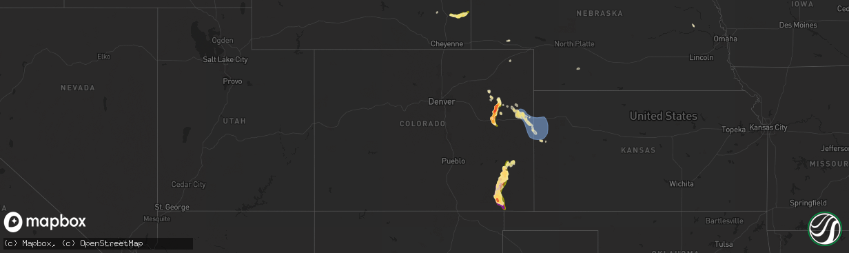
Hail Map in Colorado on August 4, 2025
The weather event in Colorado on August 4, 2025 includes Hail and Wind maps. 14 states and 271 cities were impacted and suffered possible damage. The total estimated number of properties impacted is 920.
Want more than just the map?
Turn this storm into a full workflow.
- Owner + property data so you know who to knock
- OnDemand branded weather history reports to win the "did we even have hail?" argument
- RoofTrace estimate so reps stop guessing numbers at the door
Bought this map? Upgrade within 7 days and we'll credit the $230. (10-15 min setup call)
Hail
Wind
920
Estimated number of impacted properties by a 1.00" hail or larger364
Estimated number of impacted properties by a 1.75" hail or larger242
Estimated number of impacted properties by a 2.50" hail or largerStorm reports in Colorado
Colorado
| Date | Description |
|---|---|
| 08/04/20256:58 PM CDT | A local report indicates 1.00 inch wind near 11 SSW Thurman |
| 08/04/20256:56 PM CDT | Report from mping: baseball |
| 08/04/20256:42 PM CDT | Hen egg to baseball size hail. |
| 08/04/20256:35 PM CDT | A local report indicates 2.50 inch wind near 5 SW Thurman |
| 08/04/20256:35 PM CDT | A local report indicates 2.00 inch wind near 4 SW Thurman |
| 08/04/20256:06 PM CDT | Report from mping: hen egg |
| 08/04/20255:31 PM CDT | Report from mping: ping pong ball |
| 08/04/20255:31 PM CDT | Report from mping: ping pong ball |
| 08/04/20255:30 PM CDT | Report from mping: half dollar |
| 08/04/20254:35 PM CDT | A local report indicates 1.25 inch wind near 3 WNW Gary |
| 08/04/202510:00 AM CDT | A local report indicates 3.25 inch wind near 9 ENE Kim |
| 08/03/202510:00 PM CDT | A local report indicates 3.00 inch wind near 7 E Kim |
| 08/03/202510:00 PM CDT | A local report indicates 2.00 inch wind near 6 E Kim |
| 08/03/202510:00 PM CDT | Media relayed with picture. |
| 08/03/20258:51 PM CDT | Weather station up694. |
| 08/03/20258:13 PM CDT | (bou |
| 08/03/20258:13 PM CDT | A local report indicates 3.00 inch wind near 4 E Genoa |
| 08/03/20258:10 PM CDT | Baseball size hail swath extended from 7 miles east of genoa to 4 miles east of genoa along i-70. |
| 08/03/20258:07 PM CDT | A local report indicates 1.75 inch wind near 4 E Genoa |
| 08/03/20258:04 PM CDT | Asos station kitr burlington co airport. |
| 08/03/20257:46 PM CDT | Report from mping: quarter |
| 08/03/20257:20 PM CDT | Report from mping: ping pong ball |
All States Impacted by Hail Map on August 4, 2025
Cities Impacted by Hail Map on August 4, 2025
- Gate, OK
- Laverne, OK
- Oacoma, SD
- Reliance, SD
- Chamberlain, SD
- Gregory, SD
- Electra, TX
- Holliday, TX
- Bend, OR
- Groesbeck, TX
- Mexia, TX
- Richland, TX
- Coolidge, TX
- Purdon, TX
- Dawson, TX
- Mart, TX
- Prairie Hill, TX
- Wortham, TX
- Mount Calm, TX
- Streetman, TX
- Fairfield, TX
- Teague, TX
- Montalba, TX
- Palestine, TX
- Osmond, NE
- Riesel, TX
- Donie, TX
- Thornton, TX
- Blanket, TX
- Tennessee Colony, TX
- Kosse, TX
- Marlin, TX
- Jewett, TX
- Buffalo, TX
- Hewitt, TX
- Elm Mott, TX
- Woodway, TX
- Waco, TX
- Axtell, TX
- West, TX
- Lorena, TX
- Chilton, TX
- Lott, TX
- Reagan, TX
- Marquez, TX
- Franklin, TX
- Pierce, NE
- Battle Creek, NE
- Millsap, TX
- Mineral Wells, TX
- Santo, TX
- Leona, TX
- Centerville, TX
- Midway, TX
- Madisonville, TX
- Bremond, TX
- Bryan, TX
- Hearne, TX
- Calvert, TX
- Caldwell, TX
- Normangee, TX
- North Zulch, TX
- Iola, TX
- Bedias, TX
- College Station, TX
- Montgomery, TX
- Anderson, TX
- New Waverly, TX
- Willis, TX
- Richards, TX
- Huntsville, TX
- Brenham, TX
- Washington, TX
- Somerville, TX
- Navasota, TX
- Snook, TX
- Plantersville, TX
- Chappell Hill, TX
- Palo Pinto, TX
- Conroe, TX
- Hempstead, TX
- Waller, TX
- Magnolia, TX
- Hockley, TX
- Pinehurst, TX
- Tomball, TX
- Prairie View, TX
- Spring, TX
- Cypress, TX
- Lipan, TX
- Houston, TX
- Bellaire, TX
- Pearland, TX
- Fresno, TX
- Rosharon, TX
- Stephenville, TX
- Daytona Beach, FL
- Port Orange, FL
- New Smyrna Beach, FL
- Robstown, TX
- Edgewater, FL
- Bishop, TX
- Howells, NE
- Rogers, NE
- Oak Hill, FL
- Cut Bank, MT
- Punta Gorda, FL
- Venus, FL
- Barnhart, TX
- Linn, TX
- Wheatland, WY
- Philipsburg, MT
- Ozark, IL
- Goreville, IL
- Linton, ND
- Anaconda, MT
- Labelle, FL
- Clewiston, FL
- Brush, CO
- Edinburg, TX
- Las Animas, CO
- Creal Springs, IL
- Marion, IL
- Arcadia, FL
- Mertzon, TX
- Lake Wales, FL
- Hasty, CO
- McClave, CO
- Woodrow, CO
- Akron, CO
- Ryegate, MT
- Shawmut, MT
- Okeechobee, FL
- Wiley, CO
- Molt, MT
- Ozona, TX
- Yoder, WY
- Juntura, OR
- Riverside, OR
- Hazelton, ND
- Hawk Springs, WY
- Anton, CO
- Lindon, CO
- Edgemont, SD
- Vienna, IL
- Wanblee, SD
- Brusett, MT
- Strasburg, ND
- Cope, CO
- Kenansville, FL
- Golconda, IL
- Metropolis, IL
- Harrison, NE
- Lamar, CO
- Billings, MT
- Saint Cloud, FL
- Joes, CO
- Moore, MT
- Arriba, CO
- Dryden, TX
- Genoa, CO
- Geyser, MT
- Forsyth, MT
- Kirk, CO
- Oelrichs, SD
- Hot Springs, SD
- Long Valley, SD
- Crawford, NE
- Torrington, WY
- Orlando, FL
- Pollock, SD
- Vona, CO
- Martin, SD
- Shepherd, MT
- Saint Marys, GA
- Worden, MT
- Ballantine, MT
- Huntley, MT
- Polk City, FL
- Great Falls, MT
- Oral, SD
- Andrews, TX
- Sheffield, TX
- Stratton, CO
- Pine Ridge, SD
- Flagler, CO
- Havre, MT
- Lewistown, MT
- Bethune, CO
- Stockett, MT
- Fort Stockton, TX
- Chaffee, MO
- Stanford, MT
- Crow Agency, MT
- Hardin, MT
- Monarch, MT
- Advance, MO
- Upton, WY
- Burlington, CO
- Malta, MT
- Kim, CO
- Box Elder, MT
- Geraldine, MT
- Coffee Creek, MT
- Wakpala, SD
- Belt, MT
- Kyle, SD
- Augusta, MT
- Little Eagle, SD
- McLaughlin, SD
- Arapahoe, CO
- Pritchett, CO
- Chinook, MT
- Trail City, SD
- Cascade, MT
- Fort Benton, MT
- Weskan, KS
- Lodge Grass, MT
- Garryowen, MT
- Sharon Springs, KS
- Lance Creek, WY
- Midland, SD
- Vero Beach, FL
- Lorida, FL
- Birney, MT
- Lame Deer, MT
- Newcastle, WY
- Decker, MT
- Busby, MT
- Spearfish, SD
- Beulah, WY
- Belle Fourche, SD
- Whitewood, SD
- Fleming, CO
- Hettinger, ND
- Scenic, SD
- Broadus, MT
- Biddle, MT
- Mott, ND
- Boyes, MT
- Alzada, MT
- Hammond, MT
- New Leipzig, ND
- Gurley, NE
- Sidney, NE
- Hermosa, SD
- McIntosh, SD
- Elgin, ND
- Two Dot, MT
- Judith Gap, MT
- Regent, ND
- Dickinson, ND
- Buffalo, MT
- New England, ND
- Lefor, ND
- Newell, SD
- Buffalo, SD
- Gladstone, ND
- Taylor, ND
- Richardton, ND
- Forest Grove, MT
- Roundup, MT
- Grass Range, MT
- Manning, ND
- Ingomar, MT
- Kanorado, KS
- Wallace, KS
- Goodland, KS
- Edson, KS
- Killdeer, ND
- Maywood, NE


