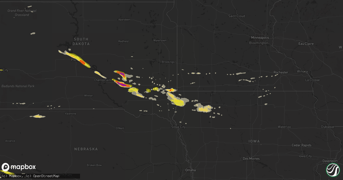
Hail Map on August 4, 2018
Get this storm
August 4 map
$229
one time, instant access
Download today. No call, no setup
Keep the $229
Bought the map and want the full workflow? Apply the entire $229 to a subscription within 7 days. None of it is wasted.
Every map, not just this one
This buys you this map. Subscription and you get every map we run, in the markets you choose from a few cities to whole states to nationwide. Plus real-time alerts the moment a storm fires.
Contact data
Name, contact info, occupancy, even credit band for addresses in the footprint. You go from where it hit to who to call.
Become the source they trust
Unlimited branding weather history reports on demand. You already have the documented answer ready for the property owner, and you are the one who showed up with it.
Property data and RoofTrace estimates
Pull up any address you have got, its value and the exact code rules for that jurisdiction, straight from One Click Code. Then RoofTrace estimates the squares, pitch, and roof value, priced the way you price.
States Impacted by Hail Map on August 4, 2018
Storm reports
New York
| Date | Description |
|---|---|
| 08/04/20185:37 PM CDT | Snapped telephone pole |
| 08/04/20185:36 PM CDT | Powerlines down along columbia turnpike. |
| 08/04/20185:28 PM CDT | Pole downed over brunswick road in eagle mills |
| 08/04/20185:19 PM CDT | Large tree limb down |
| 08/04/20185:19 PM CDT | Trees down on the mohawk hudson bikeway |
| 08/04/20185:17 PM CDT | 2 trees down along router 236 1/2 mile east of route 9. |
| 08/04/20185:17 PM CDT | Trees and wires down |
| 08/04/20185:17 PM CDT | Trees and wires down |
| 08/04/20185:09 PM CDT | Route 146 closed between river road and aqueduct road due to downed wires. |
| 08/04/20185:06 PM CDT | Tree and wires down on wood rd. |
| 08/04/20185:06 PM CDT | Wires down near wood road and route 9 in clifton park |
| 08/04/20185:05 PM CDT | Tree down on route 29 at stafford bridge rd. |
| 08/04/20184:36 PM CDT | Trees down across from the great escape along route 9. |
| 08/04/20184:27 PM CDT | Trees and wires down on burgoyne ave. |
| 08/04/20184:15 PM CDT | Trees and wires down on route 149. |
| 08/04/20184:13 PM CDT | Tree down in roadway on route 22a. |
| 08/04/20183:43 PM CDT | Trees down on route 9n |
| 08/04/20183:36 PM CDT | Tree down in roadway on stalker rd. |
| 08/04/20183:24 PM CDT | Trees and wires down. |
| 08/04/20181:35 AM CDT | At 635 PM EDT, severe thunderstorms were located along a line extending from Guilderland to near Berlin, moving southeast at 30 mph. HAZARD...60 mph wind gusts. SOURCE...Radar indicated. IMPACT...Expect damage to roofs, siding, and trees. Severe thunderstorms will be near... Berlin around 640 PM EDT. East Greenbush, Hancock and New Ashford around 650 PM EDT. Castleton-On-Hudson and Selkirk around 655 PM EDT. Ravena and Cheshire around 700 PM EDT. Nassau and New Baltimore around 705 PM EDT. Pittsfield around 710 PM EDT. Coxsackie, Valatie and Kinderhook around 715 PM EDT. Chatham around 725 PM EDT.Other locations impacted by these severe thunderstorms includeBleecker Stadium, Brookview, Van Hoesen Station, North Hancock,Cheshire Harbor, Beckers Corners, Otter Hook, Harlemville, SouthSchodack and Houcks Corners. |
| 08/04/201812:17 AM CDT | At 517 PM EDT, a severe thunderstorm was located near Lake Luzerne Campground, or 10 miles southwest of Warrensburg, moving east at 20 mph. HAZARD...60 mph wind gusts and quarter size hail. SOURCE...Radar indicated. IMPACT...Hail damage to vehicles is expected. Expect wind damage to roofs, siding, and trees. This severe thunderstorm will be near... Lake Luzerne Campground and Lake Luzerne-Hadley around 530 PM EDT. Lake George Village around 545 PM EDT. Glens Falls, Glens Falls North and West Glens Falls around 555 PM EDT.Other locations impacted by this severe thunderstorm include ThurmanStation, Cleverdale, Big Hollow, Beartown, French Mountain, LakeLuzerne, Fourth Lake, Lake George, Conklingville and Stony CreekStation. |
| 08/03/201811:09 PM CDT | At 408 PM EDT, severe thunderstorms were located along a line extending from near Hague to near North Creek, moving east at 15 mph. HAZARD...60 mph wind gusts and quarter size hail. SOURCE...Radar indicated. IMPACT...Hail damage to vehicles is expected. Expect wind damage to roofs, siding, and trees. Severe thunderstorms will be near... Johnsburg around 440 PM EDT. Eagle Point Campground and Scaroon Manor Public Campground around 500 PM EDT. Chestertown around 505 PM EDT. Warrensburg and Bolton Landing around 515 PM EDT.Other locations impacted by these severe thunderstorms includeShelving Rock, Thurman Station, Cleverdale, Sodom, Starbuckville,Edwards Hill, Wevertown, Pottersville, Holcombville and North River. |
| 08/03/20189:13 PM CDT | At 213 PM EDT, a severe thunderstorm was located near Frisbies Point, moving southeast at 5 mph. HAZARD...60 mph wind gusts and quarter size hail. SOURCE...Radar indicated. IMPACT...Minor hail damage to vehicles is possible. Expect wind damage to trees and powerlines. Locations impacted include... Essex, Willsboro, Westport, Charlotte, Mt. Philo State Park, Shelburne, Mcneil Cove, Sloop Island, Wings Point, Town Farm Bay, Meach Island, North West Bay, Hatch Point, Willsboro Point, Ligonier Point, Louis Clearing Bay, Converse Bay, Deerhead, Split Rock Point and Cold Spring Bay. |
Massachusetts
| Date | Description |
|---|---|
| 08/04/20185:39 PM CDT | Tree down on wires on johnny appleseed lane |
| 08/04/20185:26 PM CDT | Wires down on beach street |
| 08/04/20181:30 PM CDT | Large branch down in road blocking hall street |
| 08/04/20189:36 AM CDT | Large branches down and siding of building blown off in green acres estates in south grafton. |
| 08/04/20189:13 AM CDT | Scofield avenue and new boston road...road blockage debris in road. Several granite slabs were lifted and thrown in the roadway. Tree down on west main street and centr |
| 08/04/20189:05 AM CDT | Main street...chase avenue...and pleasant street...many trees and power lines down. Partial building collapse to metro pcs on main street. Several other structures on m |
| 08/04/20189:00 AM CDT | Downed tree limbs and utility poles on main street near railroad crossing. |
| 08/04/20188:48 AM CDT | *** 1 inj *** a high end ef-1 tornado... 110 mph... Struck dudley and webster... With significant damage in webster. It was 300 yards wide... 0.5 miles in length... And |
| 08/04/20188:45 AM CDT | Trees and wires down on route 198 blocking road near sturbridge line. |
| 08/03/201811:30 PM CDT | At 429 PM EDT, a severe thunderstorm was located near Aquinnah, moving northeast at 25 mph. HAZARD...60 mph wind gusts. SOURCE...Radar indicated. IMPACT...Expect damage to trees and power lines. Locations impacted include... Falmouth, Tisbury, Aquinnah, West Tisbury, Chilmark and Gosnold. |
Michigan
| Date | Description |
|---|---|
| 08/04/201812:43 AM CDT | At 542 PM EDT, a severe thunderstorm was located over L'anse, moving northeast at 45 mph. HAZARD...60 mph wind gusts. SOURCE...Radar indicated. IMPACT...Expect damage to roofs, siding, and trees. Locations impacted include... Baraga, L'anse, Skanee, The Huron Islands, Herman, Pequaming, Assinins and Point Abbaye. |
Connecticut
| Date | Description |
|---|---|
| 08/04/20188:45 AM CDT | Trees and wires down on route 198 blocking road near sturbridge line. Red head hill road has trees down. |
| 08/04/20188:44 AM CDT | Reports of trees down along route 169 and route 198. |
| 08/04/20188:36 AM CDT | Ef-0 tornado... With speeds estimated at 80 mph... Touched down on redhead hill road in northern woodstock and traveled 5 miles on a discontinous path before lifting up |
| 08/04/20184:31 AM CDT | At 931 AM EDT, a severe thunderstorm was located near Woodstock, or 16 miles northeast of Mansfield, moving northeast at 35 mph. HAZARD...60 mph wind gusts. SOURCE...Radar indicated. IMPACT...Expect damage to trees and power lines. Locations impacted include... Worcester, Shrewsbury, Grafton, Webster, Southbridge, Auburn, Burrillville, Northbridge, Oxford, Uxbridge, Millbury, Charlton, Dudley, Thompson, Sturbridge, Sutton, Douglas, Woodstock, Mendon and Millville. |
Iowa
| Date | Description |
|---|---|
| 08/04/20186:30 AM CDT | Social media user shared picture of 10 inch tree limb down on the ground. Also took down a power line. |
| 08/04/20185:45 AM CDT | Tree damage in town. Home weather station measured 68 mph. Time estimated by radar. |
| 08/04/20184:50 AM CDT | Estimated 60+ mph winds near john f kennedy park. Time estimated. |
| 08/04/20184:27 AM CDT | Large tree limbs down. Shingles off roofs. Time estimated by radar. |
| 08/04/20184:21 AM CDT | Tree branches down... Including one on church. Time estimated by radar. |
| 08/04/20184:16 AM CDT | Tree branches down... Including one on house. Time estimated by radar. |
| 08/04/20183:57 AM CDT | 59 knot gust. |
| 08/04/20183:53 AM CDT | 5 inch diameter tree snapped in half. |
| 08/04/20183:18 AM CDT | Archer fd reports 60 mph winds and heavy rain. |
| 08/04/20183:10 AM CDT | Numerous trees and power lines down in sheldon. A couple flooded roadways as well. |
| 08/04/20182:56 AM CDT | Trees and power lines down across town via sheriffs office. |
| 08/04/20182:46 AM CDT | Large tree split. Report via social media. Time estimated from radar. |
| 08/04/20182:45 AM CDT | Trees and power lines down across town via sheriffs office. |
| 08/04/20182:44 AM CDT | Large tree blown over in the city of rock valley. Report from social media... Time estimated from radar. |
Vermont
| Date | Description |
|---|---|
| 08/04/20181:10 AM CDT | At 610 PM EDT, a severe thunderstorm was located near Mechanicville, moving southeast at 25 mph. HAZARD...60 mph wind gusts and quarter size hail. SOURCE...Radar indicated. IMPACT...Hail damage to vehicles is expected. Expect wind damage to roofs, siding, and trees. This severe thunderstorm will be near... Mechanicville around 615 PM EDT. Hoosick Falls around 650 PM EDT. Grafton around 655 PM EDT.Other locations impacted by this severe thunderstorm include DeansCorners, Schaghticoke Hill, Center White Creek, Hoosick Junction,Johnsonville, Willow Glen, Coons, Wayville, Schaghticoke andBarberville. |
| 08/03/201811:28 PM CDT | At 427 PM EDT, a severe thunderstorm was located near Huletts Landing, or near Whitehall, moving south at 25 mph. HAZARD...60 mph wind gusts and quarter size hail. SOURCE...Radar indicated. IMPACT...Hail damage to vehicles is expected. Expect wind damage to roofs, siding, and trees. This severe thunderstorm will be near... Whitehall around 435 PM EDT. Comstock around 450 PM EDT. Hudson Falls and Hartford around 505 PM EDT.Other locations impacted by this severe thunderstorm include SouthBay, Middle Granville, Braymer School, Dunham Basin, Smiths Basin,Goose Island, Adamsville, North Granville, South Bay Village andSnody Dock. |
| 08/03/201811:11 PM CDT | At 410 PM EDT, a severe thunderstorm was located over Benson Landing, moving southeast at 20 mph. HAZARD...60 mph wind gusts and quarter size hail. SOURCE...Radar indicated. IMPACT...Minor hail damage to vehicles is possible. Expect wind damage to trees and powerlines. Locations impacted include... Rutland, Castleton, West Castleton, Hubbardton, Poultney Village, Tinmouth, Rutland City, Middletown Springs, Lake St. Catherine, Proctor, Benson, Poultney, Fair Haven, Clarendon, West Rutland, Ira, West Haven, Wells, Mendon and Pittsford. |
| 08/03/201810:49 PM CDT | At 349 PM EDT, a severe thunderstorm was located over Rogers Rock Campground, or 16 miles north of Whitehall, moving south at 15 mph. HAZARD...60 mph wind gusts and quarter size hail. SOURCE...Radar indicated. IMPACT...Hail damage to vehicles is expected. Expect wind damage to roofs, siding, and trees. This severe thunderstorm will be near... Hague around 400 PM EDT. Huletts Landing around 430 PM EDT. West Haven around 440 PM EDT. Whitehall around 445 PM EDT.Other locations impacted by this severe thunderstorm include LockTwelve Marina, Putnam, Dresden Center, South Bay, Chipman Point, LowHampton, Wright, Putnam Station, Silver Bay and South Bay Village. |
South Dakota
| Date | Description |
|---|---|
| 08/04/20183:55 PM CDT | A local report indicates 1.00 inch wind near 1 E DOWNTOWN RAPID CITY |
| 08/04/20183:54 PM CDT | A local report indicates 1.50 inch wind near 4 W DOWNTOWN RAPID CITY |
| 08/04/20186:29 AM CDT | At 1128 PM CDT, a severe thunderstorm was located near Crow Creek Housing, or 8 miles north of Chamberlain, moving east at 40 mph. HAZARD...70 mph wind gusts and quarter size hail. SOURCE...Radar indicated. IMPACT...Hail damage to vehicles is expected. Expect considerable tree damage. Wind damage is also likely to mobile homes, roofs, and outbuildings. This severe thunderstorm will be near... Chamberlain around 1140 pm CDT. Kimball around 1205 AM CDT.Other locations impacted by this severe thunderstorm include Pukwana. |
| 08/04/20186:14 AM CDT | At 1113 PM CDT, a severe thunderstorm was located over Counselor Creek Boat Access Area, or near Lower Brule, moving southeast at 30 mph. HAZARD...60 mph wind gusts and quarter size hail. SOURCE...Radar indicated. IMPACT...Hail damage to vehicles is expected. Expect wind damage to roofs, siding, and trees. Locations impacted include... Lower Brule, Fort Thompson, Medicine Butte, Counselor Creek Boat Access Area, Crow Creek Housing, Tailrace Rec Area, Lake Francis Case and Lake Sharpe. |
| 08/04/20185:44 AM CDT | At 1043 PM CDT, a severe thunderstorm was located near Cedar Creek Rec Area, or 17 miles northwest of Lower Brule, moving southeast at 35 mph. HAZARD...60 mph wind gusts and half dollar size hail. SOURCE...Radar indicated. IMPACT...Hail damage to vehicles is expected. Expect wind damage to roofs, siding, and trees. Locations impacted include... Lower Brule, Fort Thompson, Counselor Creek Boat Access Area, Tailrace Rec Area, Lake Sharpe, Joe Creek Rec Area, Lees Corner, Degrey Rec Area, West Bend Rec Area and Lake Francis Case. |
| 08/04/20185:00 AM CDT | At 959 PM CDT/859 PM MDT/, a severe thunderstorm was located over Pierre, moving southeast at 35 mph. HAZARD...60 mph wind gusts and half dollar size hail. SOURCE...Radar indicated. IMPACT...Hail damage to vehicles is expected. Expect wind damage to roofs, siding, and trees. Locations impacted include... Pierre, Fort Pierre, Grey Goose, Overlook Rec Area, Rousseau, West Shore Rec Area, Canning, Degrey Rec Area and Lake Sharpe. |
| 08/04/20184:37 AM CDT | At 937 PM CDT/837 PM MDT/, a severe thunderstorm was located over Oahe Mission Rec Area, or 10 miles northwest of Fort Pierre, moving southeast at 40 mph. HAZARD...60 mph wind gusts and quarter size hail. SOURCE...Radar indicated. IMPACT...Hail damage to vehicles is expected. Expect wind damage to roofs, siding, and trees. Locations impacted include... Pierre, Fort Pierre, Grey Goose, Overlook Rec Area, Spring Creek Rec Area, Cow Creek Rec Area, West Shore Rec Area, Oahe Mission Rec Area, Chantier Creek Recreation Area and Okobojo Point Rec Area. |
| 08/04/20182:50 AM CDT | Large tree blown over in the city of vermillion. Report received from social media with time estimated from radar. Damage associated with outflow boundary. |
| 08/04/20182:40 AM CDT | A local report indicates 1.25 inch wind near 5 SSW INWOOD |
| 08/04/20182:30 AM CDT | Numerous trees downed on farm property. Shingle damage to home. Time estimated from radar. Report from social media. |
| 08/04/20182:20 AM CDT | Large tree blown over in harrisburg. Report from social media. Time estimated. |
| 08/04/20182:20 AM CDT | Tree down on house. Pine tree uprooted. Via social media. |
| 08/04/20182:01 AM CDT | Dime to quarter size hail. Report via social media. |
| 08/04/20181:59 AM CDT | Fence and tree damage also noted. |
| 08/04/20181:56 AM CDT | A local report indicates 1.75 inch wind near 3 ESE SIOUX FALLS |
| 08/04/20181:55 AM CDT | Recorded with anemometer. |
| 08/04/20181:55 AM CDT | Peak wind of 68 mph recorded with anemometer. |
| 08/04/20181:51 AM CDT | Large spruce tree uprooted. Time estimated from radar. |
| 08/04/20181:47 AM CDT | Via social media. Trees down and power out at cherry rock park. |
| 08/04/20181:46 AM CDT | Light pole knocked over in downtown sioux falls. Time estimated from radar. |
| 08/04/20181:41 AM CDT | Large tree limb broken. Report time estimated by radar and received from social media. |
| 08/04/20181:04 AM CDT | A local report indicates 67 MPH wind near 3 N MITCHELL |
| 08/04/20181:02 AM CDT | Via social media picture. Time estimated off of radar. |
| 08/04/20181:01 AM CDT | At 600 PM MDT, a severe thunderstorm was located 4 miles southeast of Bear Butte State Park, or 6 miles east of Sturgis, moving east at 35 mph. HAZARD...Half dollar size hail. SOURCE...Radar indicated. IMPACT...Damage to vehicles is expected. Locations impacted include... Bear Butte State Park. |
| 08/04/201812:52 AM CDT | Hail between half inch and one inch. |
| 08/04/201812:40 AM CDT | Damage to crops... Hay bales moved... Fences and trees damaged. Path up to 100 yards wide and 2 miles long to the southeast. |
| 08/04/201812:34 AM CDT | Social media report. Time estimated by radar. |
| 08/04/201812:30 AM CDT | Vehicles and crops damaged. |
| 08/04/201812:24 AM CDT | A local report indicates 1.25 inch wind near 5 S WESSINGTON SPRINGS |
| 08/04/201812:03 AM CDT | At 502 PM MDT, a severe thunderstorm was located 4 miles southeast of Newell Lake, or 26 miles east of Belle Fourche, moving east at 30 mph. HAZARD...60 mph wind gusts and half dollar size hail. SOURCE...Radar indicated. IMPACT...Hail damage to vehicles is expected. Expect wind damage to roofs, siding, and trees. Locations impacted include... Newell, Owl Butte and Newell Lake. |
| 08/03/201811:30 PM CDT | Corrects previous hail report |
| 08/03/201811:00 PM CDT | Estimated quarter hail... Small branches down. |
| 08/03/201810:07 PM CDT | A local report indicates 67 MPH wind near PIERRE |
| 08/03/201810:00 PM CDT | Estimated 60 mph winds and dime hail. |
| 08/03/20189:52 PM CDT | At 252 PM MDT, a severe thunderstorm was located over southwestern Rapid City, moving east at 30 mph. HAZARD...Quarter size hail. SOURCE...Radar indicated. IMPACT...Damage to vehicles is expected. Locations impacted include... Rapid City, Rapid Valley, southern Box Elder, Caputa, Farmingdale, Rapid City Airport, Thompson Butte and Railroad Buttes.This Includes Interstate 90 in South Dakota between Mile Markers 56and 62. |
| 08/03/20188:07 PM CDT | At 107 AM MDT, severe thunderstorms were located along a line extending from 3 miles west of Intersection of Red Shirt and Cuny Table Roads to 11 miles east of Hay Canyon Butte, moving east at 30 mph. HAZARD...60 mph wind gusts and half dollar size hail. SOURCE...Radar indicated. IMPACT...Hail damage to vehicles is expected. Expect wind damage to roofs, siding, and trees. Locations impacted include... Oglala, Porcupine, Manderson, Wounded Knee, Rockyford, Sharps Corner and Intersection of Red Shirt and Cuny Table Roads. |
| 08/03/20187:01 PM CDT | A local report indicates 1.00 inch wind near 5 ENE DOWNTOWN STURGIS |
Colorado
| Date | Description |
|---|---|
| 08/04/20185:08 PM CDT | A local report indicates 59 MPH wind near 1 N BUCKLEY AFB |
| 08/04/20184:47 PM CDT | Estimated wind gust to 60 mph. |
| 08/04/20184:45 PM CDT | A local report indicates 58 MPH wind near 2 E LOVELAND |
| 08/03/201810:35 PM CDT | At 334 PM MDT, a severe thunderstorm was located near Sidney, moving east at 30 mph. HAZARD...60 mph wind gusts and quarter size hail. SOURCE...Radar indicated. IMPACT...Hail damage to vehicles is expected. Expect wind damage to roofs, siding, and trees. Locations impacted include... Sidney, Lodgepole, Colton, Sunol and Sidney Airport. This includes Interstate 80 in Nebraska between mile markers 53 and77. |
Minnesota
| Date | Description |
|---|---|
| 08/04/20187:17 AM CDT | At 1217 AM CDT, a severe thunderstorm was located over East Farmington, or 29 miles north of River Falls, moving east at 25 mph. HAZARD...Quarter size hail. SOURCE...Radar indicated. IMPACT...Damage to vehicles is expected. Locations impacted include... Scandia, Osceola, St. Croix Falls, Dresser, Otisville, East Farmington, Osceola Airport, Nye and William OBrien State Park. |
| 08/04/20182:52 AM CDT | 55 knot peak gust during the ten minutes preceding 259 am. Exact time estimated from radar. |
Arizona
| Date | Description |
|---|---|
| 08/03/20189:03 PM CDT | At 202 PM MST, a severe thunderstorm was located 23 miles south of Winslow, moving southeast at 10 mph. HAZARD...60 mph wind gusts and quarter size hail. SOURCE...Radar indicated. IMPACT...Hail damage to vehicles is expected. Expect wind damage to roofs, siding, and trees. This severe thunderstorm will remain over mainly rural areas OF Navajo County.This includes State Route 99 between mile markers 23 and 24. |
Ohio
| Date | Description |
|---|---|
| 08/04/20184:45 PM CDT | Several trees down on old 5 mile and forest road. Time estimated from radar. |
| 08/04/20184:40 PM CDT | Tree branches everywhere on red bank near i-71. Time estimated from radar. |
| 08/04/20184:30 PM CDT | Large tree down on reeves golf course. |
| 08/04/20184:28 PM CDT | 28066kts |
Nebraska
| Date | Description |
|---|---|
| 08/04/20184:38 PM CDT | A local report indicates 1.00 inch wind near 2 N SIDNEY |
North Dakota
| Date | Description |
|---|---|
| 08/04/20185:18 PM CDT | Mostly pea to dime size hail with a few as large as a quarter. Time estimated from radar. |
| 08/04/20183:08 AM CDT | At 808 PM CDT, a severe thunderstorm was located over Aneta, or 48 miles west of Grand Forks, moving east at 25 mph. HAZARD...Golf ball size hail and 60 mph wind gusts. SOURCE...Radar indicated. IMPACT...People and animals outdoors will be injured. Expect hail damage to roofs, siding, windows, and vehicles. Expect wind damage to roofs, siding, and trees. This severe thunderstorm will be near... Aneta around 810 PM CDT. Sharon around 830 PM CDT. Finley around 840 PM CDT. Sherbrooke around 855 PM CDT. Golden Lake around 900 PM CDT. |
| 08/04/20182:21 AM CDT | At 719 PM CDT, a severe thunderstorm was located near Pekin, or 35 miles southeast of Devils Lake, moving east at 25 mph. HAZARD...60 mph wind gusts and quarter size hail. SOURCE...Radar indicated. IMPACT...Hail damage to vehicles is expected. Expect wind damage to roofs, siding, and trees. This severe thunderstorm will be near... McVille around 735 PM CDT. Kloten around 750 PM CDT. Aneta around 805 PM CDT. |
| 08/04/201812:17 AM CDT | At 517 PM CDT, a severe thunderstorm was located 8 miles south of Hurdsfield, or 23 miles southeast of Mcclusky, moving east at 25 mph. HAZARD...60 mph wind gusts and quarter size hail. SOURCE...Radar indicated. IMPACT...Hail damage to vehicles is expected. Expect wind damage to roofs, siding, and trees. This severe thunderstorm will remain over mainly rural areas of southwestern Wells and northern Kidder Counties. |
| 08/03/20188:20 PM CDT | Shredded corn in fields along a swath one mile in width. Vicinity of sr 32/45 intersection. |
| 08/03/20188:05 PM CDT | Relayed by media via picture. |
| 08/03/20187:56 PM CDT | Image shared through social media shows crop damage due to widespread dime/nickel sized hail with reports of a few larger hail stones. Time estimated based on radar. |
| 08/03/20187:47 PM CDT | Image relayed through social media shows nickel and quarter sized hail stones. Time estimated from radar. |
Wisconsin
| Date | Description |
|---|---|
| 08/04/20184:30 AM CDT | At 930 PM CDT, severe thunderstorms were located along a line extending from 7 miles southwest of Black Creek to 7 miles south of New London, moving northeast at 45 mph. HAZARD...60 mph wind gusts. SOURCE...Radar indicated. IMPACT...Expect damage to roofs, siding, and trees. Severe thunderstorms will be near... Black Creek around 940 PM CDT. Appleton around 950 PM CDT. Little Chute around 955 PM CDT. Kaukauna around 1000 PM CDT.Other locations impacted by these severe thunderstorms includeNichols, Mackville, Leeman, Briarton, Murphy Corner, Sugar Bush,Greenville, Rose Lawn, Shiocton and Chicago Corners. |
Kentucky
| Date | Description |
|---|---|
| 08/04/20184:25 PM CDT | Several trees fell on cars. Time estimated from radar. |
Georgia
| Date | Description |
|---|---|
| 08/03/201811:11 PM CDT | At 411 PM EDT, a severe thunderstorm was located 11 miles south of Donalsonville, moving north at 20 mph. HAZARD...60 mph wind gusts. SOURCE...Radar indicated. IMPACT...Expect damage to roofs, siding, and trees. Locations impacted include... Donalsonville, Iron City, Little Hope, Lela, Sharphagen and Donaldsonville A/P. |
Pennsylvania
| Date | Description |
|---|---|
| 08/03/201811:41 PM CDT | At 440 PM EDT, a severe thunderstorm was located over Nazareth, or near Easton, moving east at 15 mph. HAZARD...60 mph wind gusts and quarter size hail. SOURCE...Radar indicated. IMPACT...Minor damage to vehicles is possible. Wind damage to roofs, siding, trees, and power lines is possible. Locations impacted include... Easton, Bethlehem, Forks, Wilson, Nazareth, Bath, Harmony, Alpha, Belfast, West Easton, Tatamy, Riegelsville, Steuben, Glendon, Old Orchard, Brass Castle, Phillipsburg, Freemansburg, Stockertown and Chapman.People attending Warren County Farmers Fair should seek safe shelterimmediately! |
Maine
| Date | Description |
|---|---|
| 08/03/20188:47 PM CDT | At 146 PM EDT, a severe thunderstorm was located over Fowler Township, or 15 miles northwest of Calais, moving northeast at 20 mph. HAZARD...60 mph wind gusts. SOURCE...Radar indicated possible rotation with this storm. IMPACT...Expect damage to trees and power lines. Locations impacted include... Princeton, Grand Lake Stream, Dyer Township, Fowler Township, Baileyville, Waite, Dyer, Big Lake and Fowler. |
Cities Impacted by Hail Map on August 4, 2018
- Hazelton, ND
- Braddock, ND
- Rapid City, SD
- Fort Yates, ND
- Humboldt, SD
- Hartford, SD
- Sioux Falls, SD
- White Lake, SD
- Plankinton, SD
- Stickney, SD
- Bridgewater, SD
- Tuttle, ND
- Houston, TX
- Shevlin, MN
- Solway, MN
- Mitchell, SD
- Mount Vernon, SD
- Sharon, ND
- Aneta, ND
- Pekin, ND
- Mcville, ND
- Hurdsfield, ND
- Salem, SD
- Sanborn, IA
- Primghar, IA
- Valley City, ND
- Nora Springs, IA
- Mason City, IA
- Olivet, SD
- Parkston, SD
- Beresford, SD
- Wessington Springs, SD
- Napoleon, ND
- Kintyre, ND
- Cooks, MI
- Canistota, SD
- Hayes, SD
- Harrold, SD
- Fort Pierre, SD
- Pierre, SD
- Lower Brule, SD
- Chamberlain, SD
- Pukwana, SD
- North Creek, NY
- Olmstedville, NY
- Currie, MN
- Slayton, MN
- Avoca, MN
- Tappen, ND
- Streeter, ND
- Merriman, NE
- Hudson, SD
- Rock Valley, IA
- Rapid River, MI
- Sidney, NE
- Holland, MN
- Pipestone, MN
- Peetz, CO
- Lancaster, MN
- Hull, IA
- Brandon, SD
- Larchwood, IA
- Jamestown, ND
- Archer, IA
- Sheldon, IA
- Williams, MN
- Baudette, MN
- Buchanan, ND
- Finley, ND
- Tolna, ND
- Montrose, SD
- Ballston Spa, NY
- Dalton, NE
- Emery, SD
- Royal, IA
- Spencer, IA
- Greenville, IA
- Lodgepole, NE
- Cleveland, ND
- Shields, ND
- Paullina, IA
- Linn Grove, IA
- Peterson, IA
- Sutherland, IA
- Wells, MN
- Minnesota Lake, MN
- Ethan, SD
- Dimock, SD
- Walhalla, ND
- Neche, ND
- Kennedy, MN
- Karlstad, MN
- Freeman, SD
- Mizpah, MN
- Woonsocket, SD
- Baldwin, ND
- Medina, ND
- Gackle, ND
- Ellendale, MN
- Inwood, IA
- Hawarden, IA
- Fairview, SD
- Worthing, SD
- Sioux Center, IA
- Canton, SD
- Harrisburg, SD
- Tea, SD
- Lemmon, SD
- Hartland, MN
- Kimball, SD
- Byron, MN
- Alden, MN
- Robinson, ND
- High Rolls Mountain Park, NM
- East Grand Forks, MN
- Delavan, MN
- Hague, NY
- Putnam Station, NY
- Monroe, SD
- Parker, SD
- Linton, ND
- Marion, SD
- Tabor, SD
- Wing, ND
- Rushmore, MN
- Reading, MN
- Wilmont, MN
- Hinton, IA
- Roseau, MN
- Winnebago, MN
- Gurley, NE
- Spiritwood, ND
- Akron, IA
- Chatsworth, IA
- Brinson, GA
- Moorland, IA
- Somers, IA
- Blooming Prairie, MN
- Ypsilanti, ND
- Saint Ansgar, IA
- Lake Wilson, MN
- Alvarado, MN
- George, IA
- Doon, IA
- Alvord, IA
- Boyden, IA
- Lennox, SD
- Ireton, IA
- Valley Springs, SD
- Corsica, SD
- Heron Lake, MN
- Storden, MN
- Tyndall, SD
- Adrian, MN
- Lismore, MN
- Tripp, SD
- Wounded Knee, SD
- Lake Bronson, MN
- New Richland, MN
- Irene, SD
- Shepherd, TX
- Cleveland, TX
- Hayfield, MN
- Letcher, SD
- Artesian, SD
- Crook, CO
- Tuthill, SD
- Selfridge, ND
- Baltic, SD
- Menno, SD
- Hurley, SD
- Kensett, IA
- Grafton, IA
- Altha, FL
- Vernon Center, MN
- Madelia, MN
- Fort Thomas, KY
- Bellevue, KY
- Newport, KY
- Webb, IA
- Dickens, IA
- Calumet, IA
- Sioux Rapids, IA
- Hartley, IA
- Laurens, IA
- Canova, SD
- Rembrandt, IA
- Oberon, ND
- Sheyenne, ND
- Saint James, MN
- Everly, IA
- Lyle, MN
- Sneads, FL
- Grand Ridge, FL
- Sanborn, ND
- Ashton, IA
- Mcclusky, ND
- Denhoff, ND
- Huron, SD
- Bainbridge, GA
- Woodstock, MN
- Colton, SD
- Fair Haven, VT
- Ticonderoga, NY
- Whitehall, NY
- Gordon, NE
- Kasson, MN
- Jeffers, MN
- Windom, MN
- Regan, ND
- Mountain Lake, MN
- Emmetsburg, IA
- Ayrshire, IA
- Blountstown, FL
- Alcester, SD
- Adams, MN
- Storm Lake, IA
- Albert City, IA
- Chancellor, SD
- Kingsley, IA
- Marathon, IA
- Volin, SD
- Mapleton, MN
- Good Thunder, MN
- Pemberton, MN
- Garden City, MN
- Cody, NE
- Chappell, NE
- Dell Rapids, SD
- Warwick, ND
- Xenia, OH
- Lewisville, MN
- Stoneham, CO
- Goodrich, ND
- Glenville, MN
- Saint Michael, ND
- Havelock, IA
- Rock Rapids, IA
- Granville, IA
- Warren, MN
- Egan, SD
- Easton, MN
- Potter, NE
- Sturgis, SD
- Fort Meade, SD