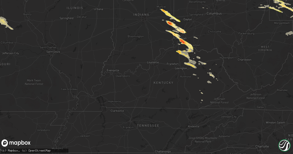
Hail Map in Kentucky on August 3, 2015
Get this storm
August 3 map
$229
one time, instant access
Download today. No call, no setup
Keep the $229
Bought the map and want the full workflow? Apply the entire $229 to a subscription within 7 days. None of it is wasted.
Every map, not just this one
This buys you this map. Subscription and you get every map we run, in the markets you choose from a few cities to whole states to nationwide. Plus real-time alerts the moment a storm fires.
Contact data
Name, contact info, occupancy, even credit band for addresses in the footprint. You go from where it hit to who to call.
Become the source they trust
Unlimited branding weather history reports on demand. You already have the documented answer ready for the property owner, and you are the one who showed up with it.
Property data and RoofTrace estimates
Pull up any address you have got, its value and the exact code rules for that jurisdiction, straight from One Click Code. Then RoofTrace estimates the squares, pitch, and roof value, priced the way you price.
Storm reports in Kentucky
Kentucky
| Date | Description |
|---|---|
| 08/03/20156:34 PM CDT | A local report indicates 1.75 inch wind near WILLIAMSTOWN |
| 08/03/20156:31 PM CDT | A local report indicates 1.00 inch wind near WILLIAMSTOWN |
| 08/03/20156:22 PM CDT | A local report indicates 1.00 inch wind near 5 SSE NEW RICHMOND |
| 08/03/20156:15 PM CDT | Report via facebook. Time estimated from radar. |
| 08/03/20156:15 PM CDT | Via media |
| 08/03/20156:14 PM CDT | A local report indicates 1.00 inch wind near ALEXANDRIA |
| 08/03/20156:10 PM CDT | Reported along otter court. |
| 08/03/20156:03 PM CDT | Via media |
| 08/02/20158:45 PM CDT | Trees were blown down throughout owingsville. |
| 08/02/20158:42 PM CDT | Trees down highway 706 and bruin hill areas. |
| 08/02/20158:37 PM CDT | Trees down on turley road. |
| 08/02/20158:35 PM CDT | Trees down in downtown mount sterling. One tree fell on a car. |
| 08/02/20158:35 PM CDT | Trees down in westbound lanes of i64. |
| 08/02/20158:30 PM CDT | Nws and bath county emergency management surveyed damage at a farm off hwy 1198. It was determined that a microburst occurred...destroying a barn and uprooting and snap |
| 08/02/20158:28 PM CDT | Trees down on nichols branch road. |
| 08/02/20158:25 PM CDT | Trees down on thompson road. |
| 08/02/20158:24 PM CDT | Trees down highway 60 at salt lick. |
| 08/02/20158:24 PM CDT | Trees were blown down throughout sharpsburg. |
| 08/02/20158:24 PM CDT | Trees down in 1700 block of highway 36w. |
| 08/02/20158:24 PM CDT | Trees down on wyoming road. |
| 08/02/20158:22 PM CDT | Trees down on bunker hill road. |
| 08/02/20158:21 PM CDT | Tree down on baldwin road. |
| 08/02/20158:18 PM CDT | Trees were blown down throughout mount sterling and the northern part of the county in general. |
| 08/02/20158:18 PM CDT | Trees down on bratton branch road |
| 08/02/20158:12 PM CDT | Trees down on south mill branch road and lambert hollow road. |
| 08/02/20158:08 PM CDT | Trees down on green bend road |
| 08/02/20157:37 PM CDT | Trees down mount carmel ave near courthouse. |
| 08/02/20157:08 PM CDT | A few trees reported down southeast of kelat...or southwest of sunrise. Time estimated from radar. |
All States Impacted by Hail Map on August 3, 2015
Cities Impacted by Hail Map on August 3, 2015
- Flemingsburg, KY
- Wallingford, KY
- Bucklin, MO
- Toronto, OH
- Spickard, MO
- Falmouth, KY
- Williamstown, KY
- Corinth, KY
- Sunray, TX
- Stratford, TX
- West Liberty, KY
- Mapleton Depot, PA
- Cassville, PA
- Three Springs, PA
- Shirleysburg, PA
- Las Animas, CO
- Hasty, CO
- Boise City, OK
- Kenton, OK
- Felt, OK
- Normalville, PA
- White, PA
- Connellsville, PA
- Scottdale, PA
- Cincinnati, OH
- Fairfield, OH
- Middletown, OH
- Mason, OH
- West Chester, OH
- Hamilton, OH
- Trenton, OH
- Salyersville, KY
- Liberty, IN
- Brownsville, IN
- Connersville, IN
- Channing, TX
- Everett, PA
- Wells Tannery, PA
- Six Mile Run, PA
- Waterfall, PA
- Hopewell, PA
- West Forks, ME
- Denver, MO
- Worth, MO
- Gentry, MO
- Albany, MO
- Hagerstown, MD
- Clear Spring, MD
- Greencastle, PA
- Big Pool, MD
- Maugansville, MD
- Gruver, TX
- Glenville, PA
- Hanover, PA
- Manchester, MD
- Glen Rock, PA
- Nottingham, PA
- Gillette, WY
- Levelland, TX
- Littlefield, TX
- Clarksburg, MD
- Leesburg, VA
- Adamstown, MD
- Tuscarora, MD
- Frederick, MD
- Dickerson, MD
- Barnesville, MD
- Cranberry Township, PA
- Maineville, OH
- Brookville, IN
- Bath, IN
- Loveland, OH
- College Corner, OH
- Oxford, OH
- West College Corner, IN
- East Setauket, NY
- Stony Brook, NY
- Saint James, NY
- Port Jefferson Station, NY
- Centereach, NY
- Belleville, PA
- Keno, OR
- Klamath Falls, OR
- Sound Beach, NY
- Manorville, NY
- Selden, NY
- Kings Park, NY
- Commack, NY
- Wading River, NY
- Middle Island, NY
- Smithtown, NY
- Coram, NY
- Cutchogue, NY
- Riverhead, NY
- East Northport, NY
- Mattituck, NY
- Ridge, NY
- Port Jefferson, NY
- Calverton, NY
- Nesconset, NY
- Miller Place, NY
- Mount Sinai, NY
- Laurel, NY
- Rocky Point, NY
- Shoreham, NY
- Lake Grove, NY
- New Suffolk, NY
- Montgomery Village, MD
- Gaithersburg, MD
- Saunderstown, RI
- Portsmouth, RI
- North Kingstown, RI
- Warren, RI
- Westport, MA
- Fall River, MA
- Somerset, MA
- Tiverton, RI
- Prudence Island, RI
- Swansea, MA
- Bristol, RI
- Jewett City, CT
- Cahone, CO
- Marienville, PA
- Ewing, KY
- Macon, MO
- Bevier, MO
- Ethel, MO
- Huntsville, MO
- Callao, MO
- Madison, MO
- New Cambria, MO
- Excello, MO
- Cairo, MO
- Jacksonville, MO
- Callensburg, PA
- Sligo, PA
- Knox, PA
- Parker, PA
- Gilman City, MO
- Coffey, MO
- New Hampton, MO
- Bethany, MO
- Jameson, MO
- Jamesport, MO
- Pattonsburg, MO
- McFall, MO
- Colebrook, NH
- Belle Vernon, PA
- Webster, PA
- Elizabeth, PA
- Monongahela, PA
- Egnar, CO
- Eglon, WV
- Lovettsville, VA
- Waterford, VA
- Ijamsville, MD
- Boyds, MD
- Jefferson, MD
- Kingfield, ME
- Phillips, ME
- Washington, PA
- Eldred, IL
- Texhoma, OK
- Texhoma, TX
- Plymouth, MA
- New Paris, PA
- Bedford, PA
- Alum Bank, PA
- Osterburg, PA
- New Enterprise, PA
- Genoa, WV
- Falmouth, IN
- Owingsville, KY
- Sharpsburg, KY
- Carlisle, KY
- Mount Sterling, KY
- Paris, KY
- Helton, KY
- Stoney Fork, KY
- Millerstown, PA
- Irwin, OH
- Milford Center, OH
- McKees Rocks, PA
- Imperial, PA
- Carnegie, PA
- Bridgeville, PA
- Presto, PA
- Pittsburgh, PA
- Oakdale, PA
- McDonald, PA
- Coraopolis, PA
- Clinton, PA
- Bulger, PA
- Hookstown, PA
- Burgettstown, PA
- Smithton, PA
- Alexandria, KY
- Brooksville, KY
- Augusta, KY
- Okeana, OH
- Brookeville, MD
- Big Creek, KY
- Oneida, KY
- Bear Branch, KY
- Hyden, KY
- Humphreys, MO
- Purdin, MO
- Anabel, MO
- Paris, MO
- Milan, MO
- Brookfield, MO
- Winigan, MO
- Clarence, MO
- Holliday, MO
- Moberly, MO
- New Boston, MO
- Browning, MO
- Harrison, OH
- Hooven, OH
- Felicity, OH
- Newport, KY
- Latonia, KY
- Foster, KY
- Moscow, OH
- Fort Thomas, KY
- Morning View, KY
- Georgetown, OH
- Bethel, OH
- West Harrison, IN
- Covington, KY
- Melbourne, KY
- Hamersville, OH
- Silver Grove, KY
- New Richmond, OH
- California, KY
- Ft Mitchell, KY
- Cleves, OH
- North Bend, OH
- Lawrenceburg, IN
- Negley, OH
- Rogers, OH
- Lisbon, OH
- East Liverpool, OH
- Central Islip, NY
- Hancock, MD
- Berkeley Springs, WV
- Hanover, MD
- Adrian, PA
- Dalhart, TX
- Shrewsbury, PA
- New Freedom, PA
- Blue Ridge Summit, PA
- Smithsburg, MD
- Freeland, MD
- Sabillasville, MD
- Warfordsburg, PA
- Westminster, MD
- Cascade, MD
- State Line, PA
- Railroad, PA
- Rouzerville, PA
- Emmitsburg, MD
- Waynesboro, PA
- Littlestown, PA
- Taneytown, MD
- Gettysburg, PA
- Mercersburg, PA
- Fairfield, PA
- Stewartstown, PA
- Needmore, PA
- Parkton, MD
- Osage, WY
- Leoti, KS
- New Bedford, MA
- Columbia, MD
- Ellicott City, MD
- Elkridge, MD
- Berry, KY
- Dumas, TX
- Dry Ridge, KY
- Clayton, NM
- Cheyenne Wells, CO
- Amity, PA
- Marianna, PA
- Scenery Hill, PA
- Ohiopyle, PA
- Peach Bottom, PA
- Drumore, PA
- Airville, PA
- Delta, PA
- Fawn Grove, PA
- Pylesville, MD
- New Park, PA
- Rayland, OH
- Mount Pleasant, OH
- Dillonvale, OH
- Adena, OH
- Martins Ferry, OH
- Saint Clairsville, OH
- Cadiz, OH
- Catonsville, MD
- Baltimore, MD
- Brooklyn, MD
- Linthicum Heights, MD
- Halethorpe, MD
- Curtis Bay, MD
- Fort Meade, SD
- Sturgis, SD
- Deadwood, SD
- Maysville, MO
- Weatherby, MO
- King City, MO
- Plympton, MA
- Alexandria, PA
- Hanover, NH
- Lebanon, NH
- Etna, NH
- Wilder, VT
- White River Junction, VT
- West Lebanon, NH
- Rangeley, ME
- Ravenwood, MO
- Carver, MA
- Middleboro, MA
- Emlenton, PA
- Rimersburg, PA
- Boulder, UT
- Plain City, OH
- Losantville, IN
- Mooreland, IN
- New Castle, IN
- Springport, IN
- Indiana, PA
- Butler, KY
- Cedar Grove, IN
- Miamitown, OH
- Germantown, KY
- Dover, KY
- New Trenton, IN
- Derry, PA
- Campton, KY
- Beattyville, KY
- New Brighton, PA
- Beaver Falls, PA
- Beaver, PA
- Rochester, PA
- Stanton, KY
- Clay City, KY
- Jackman, ME
- Sheridan, MO
- Prestonsburg, KY
- Ruffs Dale, PA
- Modoc, IN
- Williamsburg, IN
- Webster, IN
- Greens Fork, IN
- Centerville, IN
- Muncie, IN
- Richmond, IN
- Economy, IN
- Hagerstown, IN
- Chicora, PA
- Karns City, PA
- Clarion, PA
- Strattanville, PA
- West Sunbury, PA
- Petrolia, PA
- Georgetown, PA
- Midland, PA
- Sugar City, CO
- Grenville, NM
- Blain, PA
- Doylesburg, PA
- Orbisonia, PA
- Blairs Mills, PA
- James Creek, PA
- Shade Gap, PA
- Todd, PA
- Calvin, PA
- East Waterford, PA
- Dundalk, MD
- Shippenville, PA
- Bruin, PA
- Butler, PA
- Wilcox, PA
- Clarington, PA
- Johnsonburg, PA
- Sigel, PA
- Brookville, PA
- Ridgway, PA
- Schnecksville, PA
- New Tripoli, PA
- Jessup, MD
- Glen Burnie, MD
- Avella, PA
- Prosperity, PA
- Claysville, PA
- West Alexander, PA
- Cameron, MO
- Osborn, MO
- Ferron, UT
- Batesville, IN
- Maysville, KY
- Moorefield, KY
- Cynthiana, KY
- Mount Olivet, KY
- North Middletown, KY
- Stewartsville, MO
- Waterford, NY
- Watervliet, NY
- Cohoes, NY
- Troy, NY
- Melrose, NY
- Latham, NY
- Winchester, VA
- Lewistown, PA
- Parker City, IN
- Selma, IN
- Eaton, OH
- West Alexandria, OH
- Taunton, MA
- North Dighton, MA
- Stahlstown, PA
- Schaghticoke, NY
- North Stonington, CT
- Exeter, RI
- Rockville, RI
- Moosup, CT
- Voluntown, CT
- West Greenwich, RI
- Hope Valley, RI
- Wyoming, RI
- Preston, CT
- Hope, RI
- Greene, RI
- Foster, RI
- Coventry, RI
- Donora, PA
- Bunola, PA
- Finleyville, PA
- West Newton, PA
- Elrama, PA
- Clairton, PA
- West Elizabeth, PA
- Beallsville, MD
- Woodbine, MD
- Monrovia, MD
- Germantown, MD
- Mount Airy, MD
- Point Of Rocks, MD
- Damascus, MD
- Windsor, VT
- New Paris, OH
- North Dartmouth, MA
- La Belle, PA
- Denbo, PA
- Brownsville, PA
- East Millsboro, PA
- Acme, PA
- Mount Pleasant, PA
- Elkfork, KY
- Cuddy, PA
- Harrison, NE
- Amity, MO
- Union Star, MO
- Salt Lick, KY
- Hillsboro, KY
- Morehead, KY
- Newcastle, WY
- McDonough, NY
- Hauppauge, NY
- Holtsville, NY
- Ronkonkoma, NY
- Holbrook, NY
- Farmingville, NY
- Peconic, NY
- Huntington Station, NY
- Southold, NY
- Northport, NY
- Islandia, NY
- Medford, NY
- Huntington, NY
- Greenlawn, NY
- Terra Alta, WV
- Yreka, CA
- Bethany, WV
- Aliquippa, PA
- Corsica, PA
- Bethel, PA
- Myerstown, PA
- Fredericksburg, PA
- Chester, WV
- Dingess, WV
- Eldred, NY
- Barryville, NY
- Irondale, OH
- Canadian, TX
- Webbville, KY
- Kettle Island, KY
- East Brady, PA
- Glen Spey, NY
- Forestburgh, NY
- Monticello, NY
- Rock Hill, NY
- Eighty Four, PA
- Plattsburg, MO
- Clarksdale, MO
- Indian Head, PA
- Camden, OH
- Mckeesport, PA
- New Eagle, PA
- South Park, PA
- Alverton, PA
- West Mifflin, PA
- Glassport, PA
- Champion, PA
- Sutersville, PA
- Venetia, PA
- Everson, PA
- Melcroft, PA
- Hiawatha, KS
- Marsland, NE
- Mifflintown, PA
- Port Royal, PA
- McAlisterville, PA
- Newport, PA
- Thompsontown, PA
- Perham, ME
- Lenhartsville, PA
- Kempton, PA
- East Pittsburgh, PA
- Turtle Creek, PA
- Mars, PA
- Warrendale, PA
- Huntingdon, PA
- Petersburg, PA
- Des Moines, NM
- Valley Falls, NY
- Independence, KY
- Harpers Ferry, WV
- Charles Town, WV
- Fenelton, PA
- Jane Lew, WV
- Weston, WV
- Buckhannon, WV
- Rowlesburg, WV
- Parsons, WV
- Aurora, WV
- Oakland, MD
- McKenney, VA
- Dravosburg, PA
- Keyser, WV
- Elk Garden, WV
- Sparrows Point, MD
- Rosedale, MD
- Fulton, MD
- Middle River, MD
- Highland, MD
- Essex, MD
- Clarksville, MD
- Harmans, MD
- Hopkins, MO
- Parnell, MO
- Booker, TX
- Bolckow, MO
- Rosendale, MO
- Rea, MO
- Trenton, MO
- Valley Grove, WV
- Windsor Heights, WV
- Beech Bottom, WV
- Wheeling, WV
- Yorkville, OH
- Tiltonsville, OH
- Wellsburg, WV
- Ten Sleep, WY
- Savannah, MO
- Oregon, MO
- Forest City, MO
- Craig, MO
- Fillmore, MO
- Hamburg, IL
- Carrollton, IL
- New Creek, WV
- Woodsville, NH
- Clearfield, KY
- Fredericktown, PA
- Vestaburg, PA
- Waverly, VA
- Spring Grove, VA
- Westernport, MD
- Warfield, VA
- Hanksville, UT
- Torrey, UT
- Bicknell, UT
- Princeton, MO
- Penn Run, PA
- Easton, MO
- Gower, MO
- Walton, KY
- Connoquenessing, PA
- Renfrew, PA
- Evans City, PA
- Sevier, UT
- Hillsboro, OH
- Sardinia, OH
- Mount Orab, OH
- Fayetteville, OH
- Lynchburg, OH
- Green River, UT
- Gladstone, NM
- Dove Creek, CO
- Trinidad, CO
- Joseph, UT
- Turney, MO
- Helena, MO
- Bethlehem, NH
- Bretton Woods, NH
- Arapahoe, CO
- Lead, SD
- Carrollton, OH
- Philippi, WV
- Derby Line, VT
- Darlington, PA
- Monaca, PA
- Gibsonia, PA
- Freedom, PA
- Baden, PA
- Zelienople, PA
- Pritchett, CO
- Port Clinton, PA
- Auburn, PA
- Hamburg, PA
- Orwigsburg, PA
- Jeannette, PA
- Herminie, PA
- Arona, PA
- Southview, PA
- Irwin, PA
- New Cumberland, WV
- Sturgeon, PA
- Weirton, WV
- Bethel Park, PA
- Adamsburg, PA
- Rillton, PA
- Bentleyville, PA
- New Stanton, PA
- Charleroi, PA
- Canonsburg, PA
- Van Voorhis, PA
- Cecil, PA
- Midway, PA
- Greenock, PA
- Darragh, PA
- Morgan, PA
- Greensburg, PA
- Rousseau, KY
- Clayhole, KY
- Jackson, KY
- Blue River, KY
- Clayville, RI
- North Scituate, RI
- Farmington, PA
- Mill Run, PA
- Newry, ME
- East Helena, MT
- Glenelg, MD
- West Friendship, MD
- Glenwood, MD
- Mayslick, KY
- Wellsville, OH
- Round Hill, VA
- Bluemont, VA
- Canterbury, CT
- Manchester, KY
- Richmond, VT
- Newport Center, VT
- Newport, VT
- Glen Wild, NY
- Mountain Dale, NY
- Wurtsboro, NY
- Littleton, NH
- Falls City, NE
- White Cloud, KS
- Rulo, NE
- Schenectady, NY
- Albany, NY
- Smethport, PA
- Clarksville, PA
- Millsboro, PA
- Rockwood, PA
- Somerset, PA


