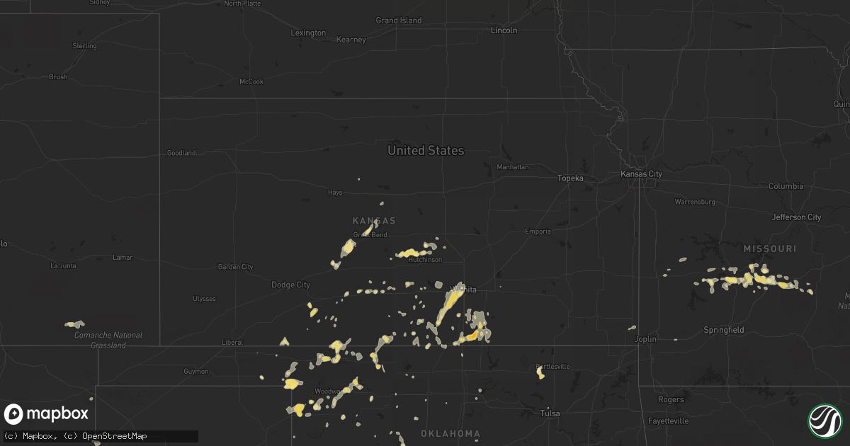
Hail Map in Kansas on August 3, 2011
Get this storm
August 3 map
$229
one time, instant access
Download today. No call, no setup
Keep the $229
Bought the map and want the full workflow? Apply the entire $229 to a subscription within 7 days. None of it is wasted.
Every map, not just this one
This buys you this map. Subscription and you get every map we run, in the markets you choose from a few cities to whole states to nationwide. Plus real-time alerts the moment a storm fires.
Contact data
Name, contact info, occupancy, even credit band for addresses in the footprint. You go from where it hit to who to call.
Become the source they trust
Unlimited branding weather history reports on demand. You already have the documented answer ready for the property owner, and you are the one who showed up with it.
Property data and RoofTrace estimates
Pull up any address you have got, its value and the exact code rules for that jurisdiction, straight from One Click Code. Then RoofTrace estimates the squares, pitch, and roof value, priced the way you price.
Storm reports in Kansas
Kansas
| Date | Description |
|---|---|
| 08/03/20116:50 PM CDT | A local report indicates 1.00 inch wind near 1 NW CAIRO |
| 08/03/20116:28 PM CDT | Shingles were torn off the roof of a house and a 2 inch diameter tree limb was blown down. |
| 08/03/20116:26 PM CDT | Power poles down at the intersection of highway 281 and 30th street. Additional power poles down within the city of pratt. |
| 08/03/20116:23 PM CDT | A local report indicates 70 MPH wind near 3 S IUKA |
| 08/02/201110:38 PM CDT | Limbs downed at hydraulic/mccarther intersection. Railroad crossing gates blown from crossing at k-15 and mccarther. |
| 08/02/201110:35 PM CDT | Shed lost part of roof. |
| 08/02/201110:35 PM CDT | Public report relayed by ksn pinpoint weather. |
| 08/02/201110:27 PM CDT | Several tree limbs were reported downed from the newton area to several miles southeast of newton. |
| 08/02/201110:25 PM CDT | Relayed through harvey county sheriff. |
| 08/02/201110:21 PM CDT | Power outages at north of pawnee between hydraulic and washington streets. |
| 08/02/201110:20 PM CDT | Power outage east of turnpike in haysville. |
| 08/02/201110:18 PM CDT | Power outages along tyler road from kellogg through maple to central avenue. |
| 08/02/201110:17 PM CDT | 10-inch diamater limb downed. |
| 08/02/201110:17 PM CDT | Tree downed at maple and woodchuck. |
| 08/02/201110:12 PM CDT | Jabarra airport. |
| 08/02/201110:05 PM CDT | Trained spotter reported 8 to 10 inch diameter tree limbs downed in his yard and estimated 70 to 80 mph wind gusts. |
| 08/02/201110:02 PM CDT | Jabarra airport. |
| 08/02/201110:00 PM CDT | Construction fence was damaged at central and west street. Roof damage reported at the plaza west shopping center at central and west. |
| 08/02/201110:00 PM CDT | A local report indicates 60 MPH wind near GEUDA SPRINGS |
| 08/02/201110:00 PM CDT | Golfball size hail was reported by the fire department. Damage to windows was reported in the area. |
| 08/02/201110:00 PM CDT | 8 to 9 inch diameter tree limbs were downed. Siding was ripped off of an apartment building. Damage occurred at pawnee and broadway. |
| 08/02/20119:58 PM CDT | Reported by off duty nws employee at central and 119th street. |
| 08/02/20119:55 PM CDT | Ranged from 60-70 mph at central and ridge. |
| 08/02/20119:55 PM CDT | Occurred at i-135 south hydraulic interchange. |
| 08/02/20119:53 PM CDT | A large diameter mature tree was snapped at 47th and hydraulic. Powerlines were downed. |
| 08/02/20119:50 PM CDT | One half mile east of gueda springs. |
| 08/02/20119:50 PM CDT | 6 inch diameter limbs downed. Relayed by kake channel 10. |
| 08/02/20119:48 PM CDT | Consistently between 60 and 70 mph. |
| 08/02/20119:45 PM CDT | Ranged from 60-70 mph. |
| 08/02/20119:45 PM CDT | Numerous tree branches downed. A 10 inch diameter tree was snapped at the base. The wet microburst lasted from 945 pm to 1005 pm. The damage occurred at pawnee and sene |
| 08/02/20119:40 PM CDT | Ranged from 60-70 mph at wfo wichita. |
| 08/02/20119:33 PM CDT | Gusts ranged from 50-60 mph 8 miles northwest of conway springs. |
| 08/02/20119:22 PM CDT | Power poles downed. Power outages reported across southern third of sumner county. |
| 08/02/20119:21 PM CDT | Power outages at north of pawnee between hydraulic and washington streets. |
| 08/02/20119:20 PM CDT | Power outage east of turnpike in haysville. |
| 08/02/20119:18 PM CDT | At least 60 mph in milan. |
| 08/02/20119:18 PM CDT | Power outages along tyler road from kellogg through maple to central avenue. |
| 08/02/20118:32 PM CDT | A local report indicates 66 MPH wind near MEDICINE LODGE |
| 08/02/20118:30 PM CDT | One inch diameter limbs downed 5 miles west of k-14 and 4 miles north of reno/kingman county line. |
| 08/02/20118:17 PM CDT | Signs blown down. Other unspecified damage reported. |
| 08/02/20118:15 PM CDT | Lawn furniture and bbq grill were blown across yard. |
| 08/02/20118:13 PM CDT | A local report indicates 60 MPH wind near 9 W PRETTY PRAIRIE |
| 08/02/20117:50 PM CDT | Small limbs downed. Power outage. |
| 08/02/20117:20 PM CDT | Large limb downed. |
All States Impacted by Hail Map on August 3, 2011
Cities Impacted by Hail Map on August 3, 2011
- Hilham, TN
- Celina, TN
- Essex, MO
- Poplar Bluff, MO
- Puxico, MO
- Bernie, MO
- Fisk, MO
- Bloomfield, MO
- Dudley, MO
- Dexter, MO
- Broseley, MO
- Wichita, KS
- Viola, KS
- Clearwater, KS
- Conway Springs, KS
- Winfield, KS
- Cedar Crest, NM
- Sandia Park, NM
- Spearman, TX
- Perryton, TX
- Waynesville, MO
- Laquey, MO
- Williamsburg, OH
- Mount Orab, OH
- Bethel, OH
- Inman, KS
- Buffalo, OK
- Tunas, MO
- Arnett, OK
- Sparta, TN
- Oklahoma City, OK
- Ravenden Springs, AR
- Townsend, MT
- Las Vegas, NM
- Montezuma, NM
- New Madrid, MO
- Cheyenne, WY
- Sharon, OK
- Heiskell, TN
- Powell, TN
- Leon, KS
- Springer, NM
- El Reno, OK
- Henry, TN
- Laverne, OK
- Great Bend, KS
- Geuda Springs, KS
- South Haven, KS
- Arkansas City, KS
- Oxford, KS
- Lewis, KS
- Kiowa, KS
- Lamar, AR
- Larned, KS
- Mooreland, OK
- Barnsdall, OK
- Louisville, KY
- Murdock, KS
- Kingman, KS
- Pretty Prairie, KS
- Tolley, ND
- Sherwood, ND
- Bell City, MO
- Sikeston, MO
- Bertrand, MO
- Elizabeth, IN
- Custer, SD
- Geary, OK
- Eldridge, MO
- Lebanon, MO
- Stoutland, MO
- Mountainair, NM
- Plaza, ND
- Umpire, AR
- Wickes, AR
- Montreal, MO
- Camdenton, MO
- Preston, MO
- Urbana, MO
- Gainesboro, TN
- Lewisburg, TN
- Roach, MO
- Macks Creek, MO
- Langley, AR
- Mena, AR
- Newhope, AR
- Mayer, AZ
- Clancy, MT
- Maxbass, ND
- Mohall, ND
- Milton, TN
- Lascassas, TN
- Murfreesboro, TN
- Rockvale, TN
- Eagleville, TN
- Forgan, OK
- Raton, NM
- Fargo, OK
- Rock Island, TN
- Estancia, NM
- Snow, OK
- Zenda, KS
- Woodward, OK
- Chester, OK
- Follett, TX
- Shattuck, OK
- Newburg, MO
- Moorcroft, WY
- Upton, WY
- Cave City, AR
- Poughkeepsie, AR
- Evening Shade, AR
- White, GA
- Buffalo, MO
- Windyville, MO
- Medicine Lodge, KS
- Englewood, KS
- Gate, OK
- Meade, KS
- Miami, TX
- Cotopaxi, CO
- Westcliffe, CO
- Lyles, TN
- Protection, KS
- Crossville, TN
- Newcastle, WY
- Grannis, AR
- Jay Em, WY
- Hermitage, MO
- Pittsburg, MO
- Louisburg, MO
- Half Way, MO
- Gillham, AR
- Cookeville, TN
- Nara Visa, NM
- Lipscomb, TX
- Rifle, CO
- Hazelton, KS
- Hardtner, KS
- Alva, OK
- Bluff City, KS
- Manchester, OK
- Medford, OK
- Harwood, MO
- Bucklin, KS
- Ford, KS
- Calumet, OK
- Cynthiana, KY
- Paris, KY
- Borger, TX
- Cunningham, KS
- Edgar Springs, MO
- Duke, MO
- Beulah, MO
- Balko, OK
- Sharon, TN
- Stinnett, TX
- Blue Creek, OH
- West Portsmouth, OH
- Otway, OH
- Stout, OH
- Haviland, KS
- Maynard, AR
- Quitman, AR
- Anthony, KS
- Livingston, TN
- Harper, KS
- Bonnerdale, AR
- Bartlesville, OK
- Sturgis, SD
- Taylorsville, KY
- Wellington, KS
- Belle Plaine, KS
- Peck, KS
- Fairview, OK
- Shelbyville, TN
- Unionville, TN
- Stamping Ground, KY
- Owenton, KY
- Frankfort, KY
- Coldwater, KS
- Spivey, KS
- Belle Fourche, SD
- Saint Onge, SD
- Spearfish, SD
- Dresden, TN
- Watertown, TN
- Pratt, KS
- Chatsworth, GA
- Mount Vernon, AR
- Romance, AR
- Carnegie, OK
- Woodland Park, CO
- Divide, CO
- Berry, KY
- Brooksville, KY
- Bokoshe, OK
- Kingston, TN
- Lenoir City, TN
- Harriman, TN
- Loudon, TN
- Humansville, MO
- Flemington, MO
- Willard, NM
- Versailles, IN
- Milan, IN
- Dillsboro, IN
- Mcminnville, TN
- Maxwell, NM
- Allardt, TN
- Robbins, TN
- Freedom, OK
- Blackwell, OK
- Paradise, KS
- Vici, OK
- Paris, TN
- Harrodsburg, KY
- Lebanon, TN
- Readyville, TN
- Tellico Plains, TN
- Vonore, TN
- Fulton, KY
- Clinton, KY
- Vale, SD
- Silver City, NM
- Watonga, OK
- Gurley, AL
- Warsaw, KY
- Dry Ridge, KY
- Richland, MO
- Pawhuska, OK
- Sunbright, TN
- Matthews, MO
- East Prairie, MO
- Hennessey, OK
- Oakdale, TN
- Wartburg, TN
- Cartersville, GA
- Kingston, GA
- Chapel Hill, TN
- Sterling, KS
- Nickerson, KS
- Walsenburg, CO
- Red Rock, OK
- Dardanelle, AR
- Winston, MT
- Albuquerque, NM
- Polk, MO
- Bolivar, MO
- Union City, TN
- South Fulton, TN
- Martin, TN
- Hiram, GA
- Columbia, TN
- Whitewood, SD
- Water Valley, KY
- Mcalester, OK
- Lancing, TN
- Franklin, TN
- Thompsons Station, TN
- Flaxton, ND
- Grandview, TN
- Kim, CO
- Black Canyon City, AZ
- Osage, WY
- Waukomis, OK
- Argonia, KS
- Goddard, KS
- Higgins, TX
- Pawnee Rock, KS
- Hutchinson, KS
- Monticello, KY
- Nash, OK
- Caldwell, KS
- Adairsville, GA
- New Liberty, KY
- Sparta, KY
- Sanders, KY
- Arlington, KS
- Perry, OK
- Morrison, OK
- Christiana, TN
- Bell Buckle, TN
- College Grove, TN
- Spring Hill, TN
- Bismarck, AR
- Amity, AR
- Fairmount, GA
- Taylorsville, GA
- Calhoun, GA
- Rydal, GA
- Biloxi, MS
- Show Low, AZ
- Heber, AZ
- Broken Bow, OK
- Tallassee, TN
- Surprise, AZ
- Howard, CO
- Canon City, CO
- Turon, KS
- Minneola, KS
- Wheatland, MO
- Quincy, MO
- Weaubleau, MO
- Osceola, MO
- Hannah, ND
- Fair Play, MO
- Dunnegan, MO
- Taloga, OK
- Amidon, ND
- Cross Plains, IN
- Monroe, TN
- Rocky Top, TN
- Andersonville, TN
- Abbyville, KS
- Walton, KY
- Verona, KY
- Beaver City, NE
- Stamford, NE
- Kinsley, KS
- Payson, AZ
- Freeport, KS
- Danville, KS
- Carlisle, KY
- Bosque, NM
- Veguita, NM
- Santa Fe, TN
- Primm Springs, TN
- Bowman, ND
- Ghent, KY
- Ola, AR
- Pampa, TX
- Horseshoe Bend, AR
- Ash Flat, AR
- Oral, SD
- Clarksville, AR
- Tulsa, OK
- Newcastle, OK
- Walhalla, ND
- Seaman, OH
- Winchester, OH
- Appleton City, MO
- Rockville, MO
- Mcpherson, KS
- Smithville, OK
- Tuttle, OK
- Blanchard, OK
- West Point, KY
- Shepherdsville, KY
- Fort Leonard Wood, MO
- Saint Robert, MO
- Oakwood, OK
- Bradyville, TN
- Hot Springs, SD
- Allons, TN
- West Union, OH
- Manchester, OH
- Greenfield, OK
- Moores Hill, IN
- Mobeetie, TX
- Kinta, OK
- Eufaula, OK
- Latonia, KY
- Alexandria, KY
- Vevay, IN
- Hemingford, NE
- Sylvia, KS
- Plevna, KS
- Cleo Springs, OK
- Dallas, GA
- Gage, OK
- Claflin, KS
- Hoisington, KS
- Iuka, KS
- Byers, KS
- Albany, KY
- Leedey, OK
- Sedona, AZ
- Seiling, OK
- Mansfield, TN
- Springville, TN
- Galena, KS
- Columbus, KS
- Weir, KS
- Charleston, MO
- Norman, AR
- Cottage Grove, TN
- Smithville, TN
- Durham, OK
- Pecos, NM
- Mandaree, ND
- Udall, KS
- Rock, KS
- Mulvane, KS
- Palmersville, TN
- Fleming, GA
- Midway, GA
- Isabella, OK
- Mountain View, OK
- Cordell, OK
- Dierks, AR
- Clayton, NM
- Arcadia, OK
- Jones, OK
- Mayfield, KS
- Helenwood, TN
- Spencer, TN
- Helena, OK
- Canadian, TX
- Dewey, AZ
- Eagletown, OK
- Watson, OK
- Twin Falls, ID
- Madisonville, TN
- Hickman, KY
- Alexandria, TN
- Brush Creek, TN
- Lockport, KY
- Okolona, AR
- Sarcoxie, MO
- Wentworth, MO
- Garfield, KS
- Bennington, IN
- Sarles, ND
- Waldron, KS
- Jamestown, TN
- Walker, MO
- Nevada, MO
- Ashland, KS
- Scottsboro, AL
- Section, AL
- Dutton, AL
- Union, KY
- Dacoma, OK
- Amarillo, TX
- Knoxville, TN
- Dorrance, KS
- Wellston, OK
- Tazewell, TN
- Cheney, KS
- Garden Plain, KS
- Andale, KS
- Haven, KS
- Mount Hope, KS
- Liberty, TN
- Rosston, OK
- Douglas, OK
- Williamsburg, KY
- Fyffe, AL
- Stockton, MO
- Newport, KY
- Woodbury, TN
- Talihina, OK
- Muse, OK
- Whitesboro, OK
- Byrdstown, TN
- Worthville, KY
- Glencoe, KY
- Gainesville, GA
- Dawsonville, GA
- Oneida, TN
- Linn Creek, MO
- Attica, KS
- Sardinia, OH
- Calvin, KY
- Pineville, KY
- Barbourville, KY
- Maryville, TN
- Moundridge, KS
- Bon Aqua, TN
- Nunnelly, TN
- Kirtland Afb, NM
- Socorro, NM
- Moriarty, NM


