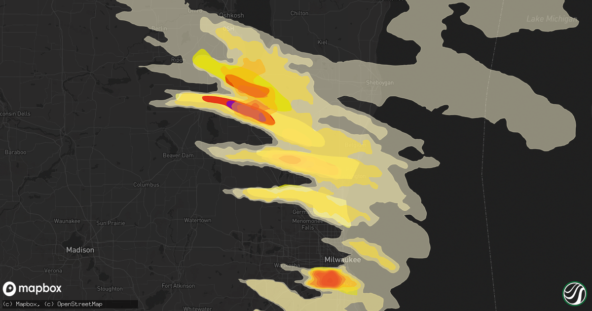
Hail Map in West Bend, WI on August 2, 2015
Get this storm
August 2 map
$229
one time, instant access
Download today. No call, no setup
Keep the $229
Bought the map and want the full workflow? Apply the entire $229 to a subscription within 7 days. None of it is wasted.
Every map, not just this one
This buys you this map. Subscription and you get every map we run, in the markets you choose from a few cities to whole states to nationwide. Plus real-time alerts the moment a storm fires.
Contact data
Name, contact info, occupancy, even credit band for addresses in the footprint. You go from where it hit to who to call.
Become the source they trust
Unlimited branding weather history reports on demand. You already have the documented answer ready for the property owner, and you are the one who showed up with it.
Property data and RoofTrace estimates
Pull up any address you have got, its value and the exact code rules for that jurisdiction, straight from One Click Code. Then RoofTrace estimates the squares, pitch, and roof value, priced the way you price.
Storm reports in West Bend, WI
West Bend, WI
| Date | Description |
|---|---|
| 08/02/20156:38 PM CDT | Relayed via twitter. |
| 08/02/20156:34 PM CDT | A local report indicates 1.75 inch wind near WEST BEND |
| 08/02/20156:33 PM CDT | A local report indicates 1.75 inch wind near 3 N WEST BEND |
| 08/02/20156:30 PM CDT | A local report indicates 2.50 inch wind near 2 NW WEST BEND |
| 08/02/20156:30 PM CDT | A local report indicates 1.25 inch wind near KOHLSVILLE |
| 08/01/20158:15 PM CDT | A local report indicates 2.00 inch wind near WEST BEND |
All States Impacted by Hail Map on August 2, 2015
All Cities Impacted by Hail Map on August 2, 2015
- Deep River, IA
- Keswick, IA
- Hebron, IN
- Malvern, IA
- Garden, MI
- Brownsville, WI
- Eldorado, WI
- Oakfield, WI
- Campbellsport, WI
- Lomira, WI
- Eden, WI
- Fond Du Lac, WI
- Etna Green, IN
- Nappanee, IN
- Warsaw, IN
- Leesburg, IN
- Van Dyne, WI
- Oshkosh, WI
- Sterling, MI
- Linden, IN
- Attica, IN
- Waynetown, IN
- Darlington, IN
- Romney, IN
- Crawfordsville, IN
- Wingate, IN
- Veedersburg, IN
- Newtown, IN
- New Richmond, IN
- Westpoint, IN
- Bringhurst, IN
- Delphi, IN
- Buck Creek, IN
- Lafayette, IN
- Rossville, IN
- Flora, IN
- Tripoli, WI
- Phillips, WI
- Brantwood, WI
- Cedar Rapids, NE
- Saint Edward, NE
- Franklin, WI
- Humphrey, NE
- Bristol, WI
- Rhinelander, WI
- Lake Tomahawk, WI
- Dyer, IN
- Highland, IN
- Schererville, IN
- Griffith, IN
- Munster, IN
- Stewartsville, MO
- Clarksdale, MO
- Amity, MO
- Canadian, TX
- Higgins, TX
- Wellston, MI
- Luther, MI
- Irons, MI
- De Pere, WI
- Caseville, MI
- Pigeon, MI
- Whittemore, MI
- Turner, MI
- National City, MI
- Tawas City, MI
- Genoa, IL
- Omro, WI
- Linwood, MI
- Kewaskum, WI
- Earth, TX
- Casco, WI
- Luxemburg, WI
- New Franken, WI
- Wausaukee, WI
- Stephenson, MI
- Green Bay, WI
- Detroit Lakes, MN
- Pickering, MO
- Ravenwood, MO
- Hopkins, MO
- Genoa City, WI
- Burlington, WI
- Lake Geneva, WI
- Elkhorn, WI
- Barton City, MI
- Spruce, MI
- Lincoln, MI
- Carp Lake, MI
- Gagetown, MI
- Unionville, MI
- Gladwin, MI
- Rock, MI
- Rapid River, MI
- Gladstone, MI
- Perkins, MI
- Mequon, WI
- Cedarburg, WI
- Germantown, WI
- Slinger, WI
- Richfield, WI
- Jackson, WI
- Monroe, IA
- Otley, IA
- Munger, MI
- Freeland, MI
- University Center, MI
- Fairgrove, MI
- Cass City, MI
- Essexville, MI
- Saginaw, MI
- Bay City, MI
- Burt, MI
- Bridgeport, MI
- Akron, MI
- Frankenmuth, MI
- Vassar, MI
- Hemlock, MI
- Carrollton, MI
- Birch Run, MI
- Reese, MI
- Caro, MI
- Merrill, MI
- Traverse City, MI
- Rudolph, WI
- Stevens Point, WI
- Bancroft, WI
- Plover, WI
- Wisconsin Rapids, WI
- Porterfield, WI
- Milan, IL
- Taylor Ridge, IL
- Reynolds, IL
- Sycamore, IL
- Dekalb, IL
- Williams, AZ
- Illinois City, IL
- Park Falls, WI
- Junction City, WI
- Pine River, WI
- Almond, WI
- Wautoma, WI
- Milladore, WI
- Vesper, WI
- Waupaca, WI
- Plainfield, WI
- Redgranite, WI
- Wild Rose, WI
- Berlin, WI
- Arpin, WI
- Grayling, MI
- Trenary, MI
- Bertha, MN
- Borger, TX
- Chino Valley, AZ
- Prescott, AZ
- Crystal Falls, MI
- Shawano, WI
- Bonduel, WI
- Sweetwater, OK
- Brethren, MI
- Clearmont, MO
- Corning, IA
- Clarinda, IA
- Darlington, MO
- Rosendale, MO
- Sheridan, MO
- Gentry, MO
- Sharpsburg, IA
- Osborn, MO
- College Springs, IA
- Gravity, IA
- Essex, IA
- New Market, IA
- Skidmore, MO
- Bedford, IA
- Coin, IA
- Nodaway, IA
- Villisca, IA
- Albany, MO
- Conception Junction, MO
- Savannah, MO
- Elmo, MO
- Stanberry, MO
- Lenox, IA
- Blanchard, IA
- Cameron, MO
- Blockton, IA
- Burlington Junction, MO
- Cosby, MO
- Clearfield, IA
- Bolckow, MO
- Braddyville, IA
- Pattonsburg, MO
- Prescott, IA
- Guilford, MO
- Weatherby, MO
- King City, MO
- Rea, MO
- Parnell, MO
- Maysville, MO
- Barnard, MO
- McFall, MO
- Maryville, MO
- Union Star, MO
- Conception, MO
- Clyde, MO
- Helena, MO
- Long Prairie, MN
- Rubicon, WI
- Hartford, WI
- Elgin, IL
- Roy, NM
- Frankfort, IN
- Creston, IA
- Glenwood, IA
- Pella, IA
- Prairie City, IA
- Abrams, WI
- Little Suamico, WI
- White Cloud, MI
- Stanwood, MI
- Franksville, WI
- Racine, WI
- Howell, MI
- Grant, IA
- Elliott, IA
- East Jordan, MI
- Diagonal, IA
- Shannon City, IA
- Lagrange, IN
- Wolcottville, IN
- Clarendon, TX
- Pampa, TX
- Manawa, WI
- Delphos, OH
- Fort Jennings, OH
- Greentop, MO
- Kirksville, MO
- Shiprock, NM
- Rockville, NE
- Ashton, NE
- Conchas Dam, NM
- Demotte, IN
- Corolla, NC
- Amarillo, TX
- Beaver Island, MI
- Jamesport, MO
- Chillicothe, MO
- Goodman, WI
- Mukwonago, WI
- Waukesha, WI
- Kansasville, WI
- Eagle, WI
- Oak Creek, WI
- Waterford, WI
- East Troy, WI
- North Prairie, WI
- Muskego, WI
- Dousman, WI
- Caledonia, WI
- Union Grove, WI
- Big Bend, WI
- Walkerton, IN
- North Liberty, IN
- Sturtevant, WI
- Vandalia, MI
- Jones, MI
- Weston, NE
- Hartland, MI
- Fenton, MI
- Yale, MI
- West Branch, MI
- Winter, WI
- Ojibwa, WI
- Hayward, WI
- Morocco, IN
- Fair Oaks, IN
- Rensselaer, IN
- Bark River, MI
- New York Mills, MN
- Hersey, MI
- Evart, MI
- Saint Helen, MI
- Menominee, MI
- Wallace, MI
- Montague, MI
- New Era, MI
- Rothbury, MI
- Frazee, MN
- Perham, MN
- Eagle Bend, MN
- Hobart, IN
- Lake Station, IN
- Oconto Falls, WI
- Ellis, KS
- Plainville, KS
- Pinconning, MI
- New Sharon, IA
- Wahoo, NE
- Prague, NE
- Linwood, NE
- Bruno, NE
- Abie, NE
- Malmo, NE
- Colon, NE
- Bartlett, IL
- Itasca, IL
- Roselle, IL
- Wood Dale, IL
- Bloomingdale, IL
- Wayne, IL
- Lombard, IL
- Medinah, IL
- Addison, IL
- Glen Ellyn, IL
- West Chicago, IL
- Glendale Heights, IL
- Hanover Park, IL
- Carol Stream, IL
- Calumet City, IL
- Chicago, IL
- Lansing, IL
- Valparaiso, IN
- Beverly Shores, IN
- South Holland, IL
- Chesterton, IN
- Chicago Heights, IL
- East Chicago, IN
- Gary, IN
- Dolton, IL
- Michigan City, IN
- Hammond, IN
- Merrillville, IN
- Portage, IN
- Whiting, IN
- Alma, MI
- Saint Louis, MI
- Breckenridge, MI
- Chatham, MI
- Howard City, MI
- Morley, MI
- Newaygo, MI
- McBain, MI
- Lake City, MI
- Dumas, TX
- Mclean, TX
- Woodstock, IL
- Niles, IL
- Hoffman Estates, IL
- Carpentersville, IL
- Wheeling, IL
- Palatine, IL
- Vernon Hills, IL
- Schaumburg, IL
- Deerfield, IL
- Barrington, IL
- Mundelein, IL
- Northbrook, IL
- Crystal Lake, IL
- Lincolnshire, IL
- Buffalo Grove, IL
- Park Ridge, IL
- Huntley, IL
- Algonquin, IL
- Mount Prospect, IL
- Cary, IL
- Fox River Grove, IL
- Elk Grove Village, IL
- Des Plaines, IL
- Arlington Heights, IL
- Glenview, IL
- Prospect Heights, IL
- Rolling Meadows, IL
- Highland Park, IL
- Lake In The Hills, IL
- Lake Zurich, IL
- Blue Grass, IA
- Rock Island, IL
- Davenport, IA
- Coal Valley, IL
- Orion, IL
- Mchenry, IL
- Wonder Lake, IL
- Elkhart, IN
- Goshen, IN
- Chalmers, IN
- Sigourney, IA
- Eland, WI
- Hatley, WI
- Maple Park, IL
- Saint Charles, IL
- Geneva, IL
- Wasco, IL
- Leroy, MI
- Tustin, MI
- Miami, TX
- Perryton, TX
- Pound, WI
- Mountain, WI
- Clinton, IL
- Mancelona, MI
- Kalkaska, MI
- Oconto, WI
- Peshtigo, WI
- Burtrum, MN
- Malone, WI
- Baldwin, MI
- Midland, MI
- Shepherd, MI
- Hazelhurst, WI
- Rochester, IN
- Kewanna, IN
- Loup City, NE
- Council Bluffs, IA
- Buffalo, IA
- Moline, IL
- Andalusia, IL
- Plainfield, IL
- Oswego, IL
- Coldwater, MI
- Quincy, MI
- Gulliver, MI
- Ogallah, KS
- Wakeeney, KS
- Mio, MI
- Lewiston, MI
- Woodburn, IA
- Lucas, IA
- Derby, IA
- Silver Lake, WI
- Twin Lakes, WI
- Salem, WI
- Trevor, WI
- Wheatfield, IN
- Panhandle, TX
- New Madison, OH
- Oregon, OH
- Curtice, OH
- Quitaque, TX
- Harwood Heights, IL
- Schiller Park, IL
- Skokie, IL
- Winfield, IL
- Lincolnwood, IL
- Franklin Park, IL
- Hampshire, IL
- Evanston, IL
- Elburn, IL
- Bensenville, IL
- Prescott, MI
- Lupton, MI
- Manton, MI
- Roscommon, MI
- Merritt, MI
- Fife Lake, MI
- Houghton Lake, MI
- Rose City, MI
- Irma, WI
- Gleason, WI
- Au Gres, MI
- Omer, MI
- Standish, MI
- Monticello, IN
- Brookston, IN
- Idaville, IN
- Yeoman, IN
- Reynolds, IN
- Battle Ground, IN
- South Boardman, MI
- Springbrook, WI
- Egg Harbor, WI
- Wheaton, IL
- Warrenville, IL
- Waterford, MI
- Pontiac, MI
- Pittsford, MI
- Camden, MI
- Jonesville, MI
- Reading, MI
- North Adams, MI
- Hillsdale, MI
- Waldron, MI
- Osseo, MI
- Ludington, MI
- Free Soil, MI
- Dearborn, MI
- Detroit, MI
- Boone Grove, IN
- Kouts, IN
- Lowell, IN
- Crown Point, IN
- Griswold, IA
- Empire, MI
- Kenosha, WI
- Mokena, IL
- Manhattan, IL
- Frankfort, IL
- Joliet, IL
- New Lenox, IL
- New Lothrop, MI
- Mount Morris, MI
- Chesaning, MI
- Clio, MI
- Montrose, MI
- Iron River, MI
- West Bend, WI
- Iron Mountain, MI
- Durand, IL
- Blythedale, MO
- Eagleville, MO
- Orient, IA
- Mission, SD
- Winner, SD
- Antioch, IL
- Spring Grove, IL
- Fox Lake, IL
- Hedrick, IA
- Kingston, IL
- Cherry Valley, IL
- Burlington, IL
- Belvidere, IL
- Steward, IL
- Malta, IL
- South Elgin, IL
- Garden Prairie, IL
- Marengo, IL
- Kirkland, IL
- Rochelle, IL
- Clare, IL
- Richmond, IL
- Cambridge, IL
- Atkinson, IL
- Brandon, WI
- Waupun, WI
- Rochert, MN
- Greenville, OH
- Hubbard Lake, MI
- Curran, MI
- Tomahawk, WI
- Custer, WI
- Mosinee, WI
- Rosholt, WI
- Port Washington, WI
- Mount Calvary, WI
- Mayville, WI
- Waldo, WI
- Pickett, WI
- Neosho, WI
- Theresa, WI
- Iron Ridge, WI
- Glenbeulah, WI
- Plymouth, WI
- Cedar Grove, WI
- Grafton, WI
- Saint Cloud, WI
- Cascade, WI
- Ripon, WI
- Milwaukee, WI
- Belgium, WI
- Elkhart Lake, WI
- Fredonia, WI
- Oostburg, WI
- Rosendale, WI
- Random Lake, WI
- Allenton, WI
- Horicon, WI
- Adell, WI
- Saukville, WI
- Parkers Prairie, MN
- Carlos, MN
- Osakis, MN
- Clarissa, MN
- Miltona, MN
- Neshkoro, WI
- Hewitt, WI
- Poy Sippi, WI
- Auburndale, WI
- Marshfield, WI
- Richmond, IN
- New Paris, OH
- Masterson, TX
- Cooks, MI
- Lakewood, WI
- Townsend, WI
- White River, SD
- Cornell, MI
- Manistique, MI
- Johannesburg, MI
- Macedonia, IA
- Carson, IA
- Marion, IN
- Buckley, MI
- Versailles, OH
- Ansonia, OH
- Rossburg, OH
- Sidney, IA
- Thurman, IA
- Muscatine, IA
- Caledonia, MI
- Kingsley, MI
- Vergas, MN
- Pelican Rapids, MN
- Couderay, WI
- Marion, MI
- New Berlin, WI
- South Milwaukee, WI
- Greendale, WI
- Hales Corners, WI
- Saint Francis, WI
- Cudahy, WI
- Henning, MN
- Hewitt, MN
- Harshaw, WI
- Madison, NE
- Leigh, NE
- Krakow, WI
- Pulaski, WI
- Sobieski, WI
- Mount Ayr, IA
- Kellerton, IA
- Athelstane, WI
- Onaway, MI
- Solano, NM
- Argonne, WI
- Wolverine, MI
- Harbor Beach, MI
- Ruth, MI
- Kennan, WI
- Minong, WI
- Gordon, WI
- Rhodes, MI
- Tippecanoe, IN
- Mentone, IN
- Creston, NE
- Erick, OK
- Portales, NM
- Williamsport, IN
- Covington, IN
- Sugar Grove, IL
- Big Rock, IL
- Lake, MI
- Sears, MI
- Butternut, WI
- Ubly, MI
- Gould City, MI
- Oneida, WI
- Seymour, WI
- New Haven, MI
- New Baltimore, MI
- Ray, MI
- Macomb, MI
- Little Lake, MI
- Nahma, MI
- Bad Axe, MI
- Akron, IN
- Harsens Island, MI
- Plano, IL
- Hinckley, IL
- Sandwich, IL
- Rodney, MI
- Chase, MI
- Idlewild, MI
- Bitely, MI
- Mecosta, MI
- Branch, MI
- Big Rapids, MI
- Reed City, MI
- Paris, MI
- Cheboygan, MI
- Brutus, MI
- Indian River, MI
- Gurnee, IL
- Great Lakes, IL
- North Chicago, IL
- Wauconda, IL
- Grayslake, IL
- Waukegan, IL
- Ingleside, IL
- Lake Forest, IL
- Libertyville, IL
- Round Lake, IL
- Harvard, IL
- Lake Villa, IL
- Wabash, IN
- Lagro, IN
- Briscoe, TX
- Ligonier, IN
- Syracuse, IN
- Trementina, NM
- Crandon, WI
- Lake Ann, MI
- Maple City, MI
- Montpelier, OH
- Edon, OH
- Pioneer, OH
- Caroline, WI
- Forestville, WI
- Lena, WI
- Algoma, WI
- Tigerton, WI
- Marion, WI
- Clintonville, WI
- Sturgeon Bay, WI
- Cecil, WI
- Brussels, WI
- Kewaunee, WI
- Suamico, WI
- Kinde, MI
- Bay Port, MI
- Elkton, MI
- Filion, MI
- Rockford, MI
- Grand Rapids, MI
- Belmont, MI
- Alpena, MI
- Ossineke, MI
- South Branch, MI
- Bayard, NE
- Trego, WI
- Archbold, OH
- Wauseon, OH
- Markesan, WI
- Green Lake, WI
- Tilleda, WI
- Leopolis, WI
- Deckerville, MI
- Palms, MI
- South English, IA
- North English, IA
- Fish Creek, WI
- Mesick, MI
- Hale, MI
- Brillion, WI
- Mount Pleasant, MI
- Wheeler, MI
- Edmore, MI
- Riverdale, MI
- Ithaca, MI
- Blanchard, MI
- Vestaburg, MI
- Elwell, MI
- Sayre, OK
- Livonia, MI
- Promise City, IA
- Bremen, IN
- Andrews, IN
- Grand Junction, MI
- Bloomingdale, MI
- Zion, IL
- Wadsworth, IL
- Winthrop Harbor, IL
- Pleasant Prairie, WI
- La Fontaine, IN
- Tucumcari, NM
- Lake Leelanau, MI
- Millington, MI
- Alger, MI
- Stanton, IA
- Cadillac, MI
- Crivitz, WI
- La Porte, IN
- Red Oak, IA
- Amherst Junction, WI
- Delta, IA
- What Cheer, IA
- Shiocton, WI
- Black Creek, WI
- Bear Creek, WI
- Watersmeet, MI
- Redding, IA
- Union City, OH
- Union City, IN
- Central Lake, MI
- Ellsworth, MI
- Northport, MI
- Converse, IN
- Yorkville, IL
- Mooresville, MO
- Wheeler, TX
- Iola, WI
- Ogdensburg, WI
- Melrose, MN
- Harrietta, MI
- Boon, MI
- Marinette, WI
- Port Hope, MI
- Jamestown, IN
- Clinton Township, MI
- Harrison Township, MI
- Mount Clemens, MI
- Hanna, IN
- Wanatah, IN
- Elmira, MI
- Harrison, MI
- New Ross, IN
- Danbury, WI
- Charlevoix, MI
- Frederic, MI
- Amberg, WI
- Tohatchi, NM
- Naperville, IL
- Russell, IA
- Downers Grove, IL
- Escanaba, MI
- Millersburg, MI
- Aurora, IL
- Lisle, IL
- Darien, IL
- Bolingbrook, IL
- Woodridge, IL
- Clare, MI
- Farwell, MI
- Powersville, MO
- Middleville, MI
- Ada, MI
- Copemish, MI
- Republican City, NE
- Fence, WI
- Allerton, IA
- Corydon, IA
- Sauk Centre, MN
- Deer Creek, MN
- Brant, MI
- Saint Charles, MI
- Peotone, IL
- Defiance, OH
- Napoleon, OH
- Milford, MI
- Williamsburg, MI
- Wabeno, WI
- Laona, WI
- Glennie, MI
- Mikado, MI
- Petoskey, MI
- Boyne City, MI
- Brown City, MI
- Cromwell, IA
- Lucerne, MO
- Henderson, IA
- Emerson, IA
- Bourbonnais, IL
- Manteno, IL
- Osco, IL
- Bowler, WI
- Hamilton, IN
- Butler, IN
- Colby, WI
- Montezuma, IA
- Indianapolis, IN
- Brownsburg, IN
- Zionsville, IN
- Catawba, WI
- Sheboygan Falls, WI
- Sheboygan, WI
- Trenton, MO
- Leighton, IA
- Lebanon, IN
- Lizton, IN
- Advance, IN
- Twining, MI
- Maria Stein, OH
- Saint Henry, OH
- Swartz Creek, MI
- Flint, MI
- Fort Recovery, OH
- Arcadia, IN
- Cicero, IN
- Kirklin, IN
- Colfax, IN
- Atlanta, IN
- Sheridan, IN
- Westfield, IN
- Noblesville, IN
- Alden, MI
- Spencerville, OH
- Saint Marys, OH
- Rose Hill, IA
- Keota, IA
- Harper, IA
- Lapeer, MI
- Whitehall, MI
- Holton, MI
- Twin Lake, MI
- Fairview, MI
- Comins, MI
- Fritch, TX
- Lake Park, MN
- Venedocia, OH
- Rapid City, MI
- Coleman, WI
- Webster, IA
- Naturita, CO
- Mulberry, IN
- Eagle River, WI
- Center Line, MI
- Warren, MI
- Winterset, IA
- Lakeview, TX
- Willowbrook, IL
- Luzerne, MI
- Afton, MI
- Beaverton, MI
- Glen Arbor, MI
- Gaylord, MI
- Suttons Bay, MI
- Sister Bay, WI
- Leland, MI
- Cedar, MI
- Elk Rapids, MI
- Kewadin, MI
- Bellaire, MI
- Baileys Harbor, WI
- Edgar, WI
- Fruitport, MI
- Ravenna, MI
- West Des Moines, IA
- Waukee, IA
- Southfield, MI
- Cleveland, WI
- Newton, WI
- Lucerne, IN
- Royal Center, IN
- Coloma, MI
- Hartford, MI
- Watervliet, MI
- Scotia, NE
- North Loup, NE
- Arcadia, MI
- Bear Lake, MI
- Bruce Crossing, MI
- Cedar Lake, IN
- Manistee, MI
- Scottville, MI
- Black River, MI
- Cainsville, MO
- Hatfield, MO
- Ridgeway, MO
- Lamoni, IA
- Colome, SD
- Silver Lake, IN
- Flushing, MI
- Denmark, WI
- Green Valley, WI
- Deerbrook, WI
- Westmont, IL
- Sterling Heights, MI
- Norris, SD
- Burnettsville, IN
- Litchfield, NE
- Marenisco, MI
- McClelland, IA
- Benton Harbor, MI
- Logansport, IN
- Lachine, MI
- Hoopeston, IL
- Thorntown, IN
- Pittsboro, IN
- Ladoga, IN
- Whitestown, IN
- Cassopolis, MI
- Edwardsburg, MI
- Niles, MI
- Spencer, WI
- Chili, WI
- Amherst, WI
- Menomonee Falls, WI
- Pelican Lake, WI
- Greenfield, IA
- Boyne Falls, MI
- Walloon Lake, MI
- Shenandoah, IA
- Audubon, MN
- Beecher, IL
- Winamac, IN
- Thayer, IN
- Lake Village, IN
- Grant Park, IL
- Olton, TX
- Marlette, MI
- Kewanee, IL
- Martensdale, IA
- Prole, IA
- Norwalk, IA
- Claude, TX
- Ord, NE
- Chula, MO
- Indianola, IA
- New Virginia, IA
- Ogema, WI
- Chilton, WI
- Valders, WI
- Saint Nazianz, WI
- Kiel, WI
- Rochester, WI
- Farwell, NE
- Elba, NE
- Pentwater, MI
- Palestine, OH
- Custer, MI
- Walkerville, MI
- Remus, MI
- Wyandotte, MI
- Lincoln Park, MI
- Southgate, MI
- Muskegon, MI
- Roann, IN
- Thompsonville, MI
- Clarks Hill, IN
- Gibsonburg, OH
- Woodville, OH
- Albany, MN
- Freeport, MN
- Plymouth, IN
- Oak Park, IL
- Minocqua, WI
- Two Rivers, WI
- South Bend, IN
- Michigantown, IN
- Rockton, IL
- New Weston, OH
- Argos, IN
- Gibson, IA
- Saint Charles, IA
- Powers, MI
- Wilson, MI
- Carney, MI
- Beulah, MI
- Interlochen, MI
- Benzonia, MI
- Momence, IL
- Scott, OH
- Payne, OH
- Haviland, OH
- Battle Creek, MI
- Marshall, MI
- South Haven, MI
- Franklin, MI
- Bloomfield Hills, MI
- West Bloomfield, MI
- Birmingham, MI
- Farmington, MI
- Levering, MI
- Macy, IN
- Scandinavia, WI
- Weyauwega, WI
- Walton, IN
- Lac Du Flambeau, WI
- Fifield, WI
- Harbor Springs, MI
- Alma, NE
- Cumming, IA
- Van Meter, IA
- Burnett, WI
- Grosse Pointe, MI
- Harper Woods, MI
- Nichols, WI
- Falmouth, MI
- Dowagiac, MI
- Otterbein, IN
- Brimhall, NM
- Osceola, IA
- Van Wert, IA
- Weldon, IA
- Avon, MN
- Albion, IN
- Kawkawlin, MI
- Herron, MI
- Kohler, WI
- Browerville, MN
- Skellytown, TX
- Saint Johns, MI
- Benton, IA
- Sidney, OH
- Anna, OH
- Cicero, IL
- Forest Park, IL
- Golf, IL
- La Grange Park, IL
- Island Lake, IL
- Lockport, IL
- Stone Park, IL
- Homer Glen, IL
- Montgomery, IL
- Sebewaing, MI
- Melrose Park, IL
- Grawn, MI
- Clarendon Hills, IL
- Bentley, MI
- Darien, WI
- Tinley Park, IL
- Bristol, IL
- Springfield, WI
- Bellwood, IL
- Hinsdale, IL
- Highwood, IL
- River Forest, IL
- Rockford, IL
- Port Austin, MI
- Romeoville, IL
- Palos Park, IL
- Elmhurst, IL
- Long Lake, MI
- North Aurora, IL
- Brookfield, IL
- Lemont, IL
- Orland Park, IL
- Villa Park, IL
- Mishicot, WI
- Hillside, IL
- Palos Hills, IL
- Winneconne, WI
- Ringwood, IL
- Riverside, IL
- Willow Springs, IL
- Cortland, IL
- River Grove, IL
- Summit Argo, IL
- Kenilworth, IL
- Lake Bluff, IL
- Dundee, IL
- Western Springs, IL
- Delavan, WI
- Berwyn, IL
- Oak Forest, IL
- Maywood, IL
- Hines, IL
- Oak Brook, IL
- Berkeley, IL
- Broadview, IL
- Owendale, MI
- La Grange, IL
- Batavia, IL
- Winnetka, IL
- Morton Grove, IL
- Westchester, IL
- Glencoe, IL
- Elmwood Park, IL
- Lyons, IL
- Wilmette, IL
- Virginia Beach, VA
- Suring, WI
- Frankfort, MI
- Coldwater, OH
- Celina, OH
- Monon, IN
- Forreston, IL
- Mishawaka, IN
- Hermansville, MI
- Wells, MI
- Wolcott, IN
- Remington, IN
- Camden, IN
- Ravenna, NE
- Pittsville, WI
- Berrien Springs, MI
- Berrien Center, MI
- West Lebanon, IN
- Mellott, IN
- North Branch, MI
- Grovertown, IN
- Medford, WI
- Litchfield, MI
- Homer, MI
- Harrisville, MI
- Snover, MI
- Harvey, IL
- Country Club Hills, IL
- Richton Park, IL
- Olympia Fields, IL
- Flossmoor, IL
- Matteson, IL
- Bourbon, IN
- Atwood, IN
- Wakarusa, IN
- Milford, IN
- New Paris, IN
- Onekama, MI
- Kaleva, MI
- Brookville, IN
- Connersville, IN
- Palmer, NE
- Marathon, WI
- Pellston, MI
- New Holstein, WI
- Atlanta, MI
- Bethany, MO
- Gilman City, MO
- Covert, MI
- Prentice, WI
- Grant City, MO
- Harrison, NE
- Land O'Lakes, WI
- Annawan, IL
- Francesville, IN
- Williams Bay, WI
- Eau Claire, MI
- Deford, MI
- Kingston, MI
- Montgomery, MI
- Fertile, MN
- Bejou, MN
- Gary, MN
- Callaway, MN
- Waubun, MN
- Mahnomen, MN
- Ogema, MN
- White Earth, MN
- Twin Valley, MN
- Three Lakes, WI
- Fremont, WI
- Hudson, MI
- Mineola, IA
- Morse Bluff, NE
- Reasnor, IA
- Brady, NE
- Maxwell, NE
- North Platte, NE
- Chappell, NE
- Oshkosh, NE
- Big Springs, NE
- Lewellen, NE
- Anselmo, NE
- Sargent, NE
- Taylor, NE
- Burwell, NE
- Broken Bow, NE
- Ansley, NE
- Westerville, NE
- Comstock, NE
- Arcadia, NE
- Florence, WI


