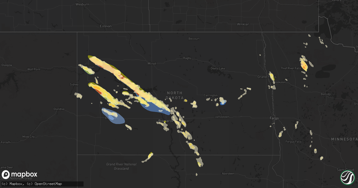
Hail Map in North Dakota on August 1, 2023
Get this storm
August 1 map
$229
one time, instant access
Download today. No call, no setup
Keep the $229
Bought the map and want the full workflow? Apply the entire $229 to a subscription within 7 days. None of it is wasted.
Every map, not just this one
This buys you this map. Subscription and you get every map we run, in the markets you choose from a few cities to whole states to nationwide. Plus real-time alerts the moment a storm fires.
Contact data
Name, contact info, occupancy, even credit band for addresses in the footprint. You go from where it hit to who to call.
Become the source they trust
Unlimited branding weather history reports on demand. You already have the documented answer ready for the property owner, and you are the one who showed up with it.
Property data and RoofTrace estimates
Pull up any address you have got, its value and the exact code rules for that jurisdiction, straight from One Click Code. Then RoofTrace estimates the squares, pitch, and roof value, priced the way you price.
Storm reports in North Dakota
North Dakota
| Date | Description |
|---|---|
| 08/01/20236:59 PM CDT | Relayed through broadcast media. |
| 08/01/20236:47 PM CDT | Report from mping. |
| 08/01/20236:42 PM CDT | Large cottonwood tree branches blown down... Report from social media. |
| 08/01/20236:37 PM CDT | Delayed report from august 1. Time estimated from radar. Report of golf ball sized hail. |
| 08/01/20236:25 PM CDT | Relayed by broadcast media. |
| 08/01/20236:24 PM CDT | Hail report from social media. |
| 08/01/20236:20 PM CDT | Heavy rain... Wind gusts 30 to 40 mph. |
| 08/01/20236:18 PM CDT | 5ne big bend ndawn site. |
| 08/01/20236:15 PM CDT | Delayed report from august 1. Estimated quarter sized hail. |
| 08/01/20236:10 PM CDT | Delayed report from august 1. The end tower of an irrigation pivot was blown over. The pivot was not running at the time. Estimated wind speed is 70 mph. Time estimated |
| 08/01/20236:05 PM CDT | Relayed by broadcast media... Dime to quarter in size. |
| 08/01/20235:47 PM CDT | A local report indicates 1.00 inch wind near 5 SW Williston |
| 08/01/20235:41 PM CDT | Wind gusts to 60 mph. |
| 08/01/20235:25 PM CDT | Mesonet station 324219 12 sse ray |
| 08/01/20235:25 PM CDT | Large tree blown down and uprooted... Time estimated by radar. Relayed via social media. |
| 08/01/20235:24 PM CDT | Hail report and image from social media. |
| 08/01/20235:20 PM CDT | Mesonet station 324219 12 sse ray |
| 08/01/20235:02 PM CDT | Heavy rain with estimated winds of 30 to 40 mph. |
| 08/01/20233:55 PM CDT | Delayed report relayed by broadcast media. A large amount of quarter size hail created significant dents on a garage door and shattered a window. Time estimated from ra |
| 07/31/202310:11 PM CDT | Williams lookout raws site - 12 e mott. |
| 07/31/20239:15 PM CDT | Information provided by broadcast media partner. |
| 07/31/20239:08 PM CDT | Delayed report from august 1. Estimated 60 mph wind gust with the gust front ahead of storms. No rain with wind gust. Clay flower plants dumped out and broken. |
| 07/31/20239:06 PM CDT | In combination with 80 mph storm gust. |
| 07/31/20239:03 PM CDT | 75 to 80 mph wind gust. |
| 07/31/20238:58 PM CDT | Awos station khze hazen. |
| 07/31/20238:52 PM CDT | A local report indicates 1.00 inch wind near Washburn |
| 07/31/20238:45 PM CDT | Golf ball size hail reported from social media... Lasted 5-7 minutes. 1.30 inches of rain. |
| 07/31/20238:38 PM CDT | Mesonet station 322189 1 nw dickinson |
| 07/31/20238:31 PM CDT | Relayed through broadcast media of hail covering the ground north of hazen. Largest size was pictured around ping pong ball sized. Time estimated based on radar. |
| 07/31/20238:12 PM CDT | Facebook report and photos a thunderstorm wind damage to a building... Grain bins... And corral. Time estimated based on radar. |
| 07/31/20238:08 PM CDT | Hail report from trained weather spotter. |
| 07/31/20238:05 PM CDT | Ndawn hazen 2w. |
| 07/31/20238:04 PM CDT | Delayed report from august 1. Relayed through social media. Averaged nickel to quarter size but largest was ping pong ball size. Time estimated from radar. |
| 07/31/20238:00 PM CDT | Heavy rain... Dime hail. |
| 07/31/20237:57 PM CDT | Relayed via social media... Time estimated by radar. |
| 07/31/20237:56 PM CDT | A local report indicates 64 MPH wind near 2 E Hazen |
| 07/31/20237:50 PM CDT | Mesonet station 324019 2 w hazen |
| 07/31/20237:43 PM CDT | Delayed report from july 1st storm event. |
| 07/31/20237:43 PM CDT | Delayed report from aug 1st storm event. This is to correct a remarks from a previous lsr. |
| 07/31/20237:42 PM CDT | Delayed report from august 1. Quarter size hail fell for 14 minutes. Time estimated from radar. Also had 1.78 inches of rain. |
| 07/31/20237:37 PM CDT | Delayed report from august 1. Hail estimated at quarter and half dollar size. Report from social media. |
| 07/31/20237:30 PM CDT | Mesonet station 321815 5 se kensal |
| 07/31/20237:25 PM CDT | Time estimated by radar 725 pm to 735 pm. Reports of damage... From thunderstorm winds... To homes and campers in the beulah bay and hazen bay areas. The extent of the |
| 07/31/20237:25 PM CDT | Mesonet station 321815 5 se kensal |
| 07/31/20237:18 PM CDT | Relayed through broadcast media... Pictures of four campers blown over in white shield. Time estimated based on radar. |
| 07/31/20237:18 PM CDT | Picture relayed through broadcast media of hail bigger than a quarter in twin buttes. Time estimated based on radar. |
| 07/31/20237:13 PM CDT | Delayed report from the evening of august 1. Photos and information passed on to nws by broadcast media partner. A home had its vinyl siding significantly damaged by wi |
| 07/31/20237:11 PM CDT | Heavy rain with winds estimated 50 to 60 mph. |
All States Impacted by Hail Map on August 1, 2023
Cities Impacted by Hail Map on August 1, 2023
- Roseau, MN
- Wannaska, MN
- Salol, MN
- Warroad, MN
- Bastrop, LA
- Florence, MO
- Otterville, MO
- Smithton, MO
- Grygla, MN
- Strathcona, MN
- Greenbush, MN
- Grafton, ND
- Lebanon, MO
- Phillipsburg, MO
- Roosevelt, MN
- Cheyenne, WY
- Fe Warren Afb, WY
- Conifer, CO
- Pine, CO
- McIntosh, SD
- Selfridge, ND
- Buffalo Creek, CO
- East Grand Forks, MN
- Fisher, MN
- Williston, ND
- Epping, ND
- Ray, ND
- Goodridge, MN
- Woodrow, CO
- Wellington, CO
- Tioga, ND
- Carr, CO
- New Town, ND
- Stanley, ND
- Alexander, ND
- Williams, MN
- Finley, ND
- Manor, GA
- Walsenburg, CO
- Fargo, GA
- Oakley, ID
- Detroit Lakes, MN
- Pelican Rapids, MN
- White River, SD
- Reynolds, ND
- Sharon, ND
- Aguilar, CO
- Trinidad, CO
- Climax, MN
- Buxton, ND
- Trinchera, CO
- Cooperstown, ND
- Luverne, ND
- Guffey, CO
- Burley, ID
- Malta, ID
- Gatzke, MN
- Bailey, CO
- Hatton, ND
- Kim, CO
- Woodland Park, CO
- Colorado Springs, CO
- Belvidere, SD
- Red Lake Falls, MN
- Aneta, ND
- Watauga, SD
- Pritchett, CO
- Las Animas, CO
- Baxley, GA
- Gardner, CO
- Vergas, MN
- Westcliffe, CO
- Evergreen, CO
- Millwood, GA
- Waycross, GA
- Axson, GA
- Audubon, MN
- Cotopaxi, CO
- Pierre, SD
- Mandan, ND
- Bismarck, ND
- Parshall, ND
- Ryder, ND
- Roseglen, ND
- Garrison, ND
- Killdeer, ND
- Watford City, ND
- Arnegard, ND
- Grassy Butte, ND
- Briggsdale, CO
- Courtenay, ND
- Kensal, ND
- Hazen, ND
- Beulah, ND
- Stanton, ND
- Dunn Center, ND
- Fort Morgan, CO
- Grover, CO
- Tuthill, SD
- New Salem, ND
- Washburn, ND
- Underwood, ND
- Center, ND
- Wilton, ND
- Baldwin, ND
- Manning, ND
- Dickinson, ND
- Gladstone, ND
- Belfield, ND
- Fairfield, ND
- Taylor, ND
- Richardton, ND
- Saint Francis, SD
- Akron, CO
- Otis, CO
- Yuma, CO
- Eckley, CO
- Wray, CO
- Vernon, CO
- Lambert, MT
- Cope, CO
- Eagle Butte, SD
- Gordon, NE
- Vona, CO
- Flagler, CO
- Seibert, CO
- Weldona, CO
- Cartwright, ND
- Savage, MT
- Martin, SD
- Fort Pierre, SD
- Miltona, MN
- Fort Stewart, GA
- Ludowici, GA
- Hinesville, GA
- Arriba, CO
- Parkers Prairie, MN
- Fosston, MN
- Orchard, CO
- Carrington, ND
- New York Mills, MN
- Pingree, ND
- Regan, ND
- Mcclusky, ND
- Byers, CO
- Kit Carson, CO
- Merriman, NE
- Kindred, ND
- Horace, ND
- Wolverton, MN
- Barnesville, MN
- Robinson, ND
- New Raymer, CO
- Sterling, ND
- Anton, CO
- Merino, CO
- Lyons, CO
- Dodge, ND
- Halliday, ND
- Golden Valley, ND
- Moorhead, MN
- Trail, MN
- Gully, MN
- Sterling, CO
- Wing, ND
- Rothsay, MN
- Wiggins, CO
- Roggen, CO
- Zap, ND
- Ault, CO
- Garfield, MN
- Vining, MN
- Tuttle, ND
- Las Vegas, NV
- Kersey, CO
- Deer Creek, MN
- Goodrich, ND
- Hurdsfield, ND
- Driscoll, ND
- Grosse Tete, LA
- Genoa, CO
- Woodworth, ND
- Gonvick, MN
- Homerville, GA
- Louisville, GA
- Bartow, GA
- Limon, CO
- Riverdale, ND
- Lindon, CO
- Snyder, CO
- Kent, MN
- Wadley, GA
- Lake Butler, FL
- Longmont, CO
- Humphreys, MO
- Galt, MO
- Milan, MO
- Browning, MO
- Eureka, SD
- Saint Anthony, ND
- Chappell, NE
- Oshkosh, NE
- Lodgepole, NE
- Mott, ND
- Avoca, IA
- Neola, IA
- Minden, IA
- Ogallala, NE
- Lewellen, NE
- Lemoyne, NE
- Keystone, NE
- Spickard, MO
- Harris, MO
- Scott City, KS
- Elm Creek, NE
- Bertrand, NE
- Smithfield, NE
- McCook, NE
- Benkelman, NE
- McDonald, KS
- Saint Francis, KS
- Bird City, KS
- Elwood, NE
- Bingham, NE
- Wood River, NE
- Eustis, NE
- Denver, MO
- Grant City, MO
- Amherst, NE
- Carlos, MN
- Indianola, NE
- Lexington, NE
- Missouri Valley, IA
- Honey Creek, IA
- Sturgeon, MO
- Harrisburg, MO
- Clark, MO
- Kirk, CO
- Burlington, CO
- Idalia, CO
- Braddock, ND
- New Leipzig, ND
- Shelby, IA
- Haigler, NE
- Ethel, MO
- Farnam, NE
- Stockville, NE
- Moorefield, NE
- Maywood, NE
- Curtis, NE
- Overton, NE
- Wishek, ND
- Linton, ND
- Hebron, ND
- Hazelton, ND
- Kintyre, ND
- Armstrong, MO
- Fayette, MO
- Higbee, MO
- Hague, ND
- Zeeland, ND
- Menoken, ND
- Moffit, ND
- Joes, CO
- Fulton, MO
- Mokane, MO
- Tebbetts, MO
- New Bloomfield, MO
- Leoti, KS
- Sauk Centre, MN
- Long Prairie, MN
- Osakis, MN
- Princeton, MO
- Purdin, MO
- Laredo, MO
- Trenton, MO
- New Cambria, MO
- Rushville, NE
- Glasgow, MO
- Breckenridge, MN
- Fergus Falls, MN
- Napoleon, ND
- Lewis, IA
- Oakland, IA
- Blair, NE
- Walnut, IA
- Logan, IA
- Hancock, IA
- Underwood, IA
- Glenfield, ND
- Bucklin, MO
- Atwood, KS
- Monument, KS
- Atlantic, IA
- Columbia, MO
- Parks, NE
- Steele, ND
- Callao, MO
- Bevier, MO
- Excello, MO
- Cozad, NE
- Hayes Center, NE
- Culbertson, NE
- Delphos, KS
- Healy, KS
- Lebanon, NE
- Huntsville, MO
- Moberly, MO
- Cody, NE
- Cainsville, MO
- Bloomington, NE
- Franklin, NE
- Mandaree, ND
- Big Springs, NE
- Bartley, NE
- Chamois, MO
- Linn, MO
- Bonnots Mill, MO
- New Boston, MO
- Elmwood, NE
- Palmyra, NE
- Unadilla, NE
- Harlan, IA
- Hosmer, SD
- Salisbury, MO
- Clifton Hill, MO
- Leon, IA
- Davis City, IA
- Decatur, IA
- Hill City, KS
- Woodbine, IA
- Bourbon, MO
- Cuba, MO
- Sullivan, MO
- Fremont, NE
- Massena, IA
- Winona, KS
- Nehawka, NE
- Avoca, NE
- Weeping Water, NE
- Murray, NE
- Green City, MO
- Brookfield, MO
- Marceline, MO
- Linneus, MO
- Winigan, MO
- Shannon City, IA
- Diagonal, IA
- Creston, IA
- Lenox, IA
- Elmer, MO
- Ashley, ND
- Eagleville, MO
- Blythedale, MO
- Dannebrog, NE
- Alexander, KS
- Portsmouth, IA
- Persia, IA
- Murray, IA
- Osceola, IA
- Hatfield, MO
- Thayer, IA
- Afton, IA
- Macksburg, IA
- Mount Ayr, IA
- Tingley, IA
- Mercer, MO
- Saint Paul, NE
- Palmer, NE
- Green Castle, MO
- Valentine, NE
- Madison, MO
- Hallsville, MO
- Centralia, MO
- Grand River, IA
- Loose Creek, MO
- Lenora, KS
- Pollock, MO
- Owensville, MO
- Arlington, NE
- Henning, MN
- Bowdle, SD
- Kenesaw, NE
- Martinsville, MO
- Cairo, MO
- Kingdom City, MO
- Fort Calhoun, NE
- Kellerton, IA
- Rosebud, MO
- Lucerne, MO
- Newtown, MO
- Van Wert, IA
- Mondamin, IA
- Pisgah, IA
- Miller, NE
- Laclede, MO
- Macon, MO
- Keytesville, MO
- Blanchard, IA
- Westboro, MO
- Panama, IA


