Hail Map in South Carolina on August 1, 2013
Get this storm
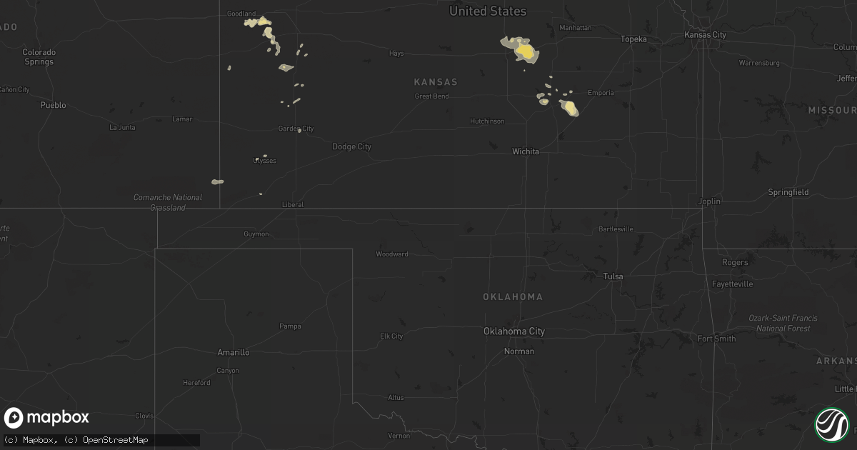
August 1 map
$229
one time, instant access
Download today. No call, no setup
Keep the $229
Bought the map and want the full workflow? Apply the entire $229 to a subscription within 7 days. None of it is wasted.
Every map, not just this one
This buys you this map. Subscription and you get every map we run, in the markets you choose from a few cities to whole states to nationwide. Plus real-time alerts the moment a storm fires.
Contact data
Name, contact info, occupancy, even credit band for addresses in the footprint. You go from where it hit to who to call.
Become the source they trust
Unlimited branding weather history reports on demand. You already have the documented answer ready for the property owner, and you are the one who showed up with it.
Property data and RoofTrace estimates
Pull up any address you have got, its value and the exact code rules for that jurisdiction, straight from One Click Code. Then RoofTrace estimates the squares, pitch, and roof value, priced the way you price.
Storm reports in South Carolina
South Carolina
| Date | Description |
|---|---|
| 08/01/20136:08 PM CDT | County sheriff reported a large tree down at the intersection of hamms landing road and macedonia church road. |
| 08/01/20135:53 PM CDT | Sc hwy patrol reported trees down on parr road. |
| 08/01/20135:21 PM CDT | Fairfield electric coop reported large limbs down on a line along timberlane circle. |
| 08/01/20133:48 PM CDT | Tree down near intersection of sc hwy 49 and sc hwy 308 |
| 08/01/20133:15 PM CDT | Tree down near intersection of nash mill rd. And tall pines rd. |
| 08/01/20132:10 PM CDT | Tree down on a house on 3rd street. |
| 08/01/20131:50 PM CDT | Trees down near travelers rest. Us 25 and roe ford rd...near intersection of altamont and new altamont rds...poinsett hwy and old buncombe rd...also power lines down al |
| 08/01/20137:12 AM CDT | Highway patrol reported a tree down near the intersection of pond road and lewis waters road. |
| 08/01/20137:10 AM CDT | Power outages near leesville were the result of limbs and trees down on power lines. |
| 07/31/20137:35 PM CDT | Highway patrol reported trees down at exit 44 along i-20. |
| 07/31/20137:33 PM CDT | Highway patrol reported trees down at the intersection of quattlebaum road and two notch road. |
All States Impacted by Hail Map on August 1, 2013
Cities Impacted by Hail Map on August 1, 2013
- Burwell, NE
- Lynch, NE
- Oneill, NE
- Verdigre, NE
- Austin, MN
- Billings, MT
- Springview, NE
- Kimball, SD
- Wiley, CO
- Lamar, CO
- Marsland, NE
- Alliance, NE
- Hay Springs, NE
- Hemingford, NE
- Chadron, NE
- Ellsworth, NE
- Dillon, MT
- Silver Star, MT
- Twin Bridges, MT
- Glen, MT
- Gillette, WY
- Ord, NE
- North Loup, NE
- Padroni, CO
- Wesley, IA
- Bancroft, IA
- Titonka, IA
- Algona, IA
- Burt, IA
- Lone Rock, IA
- Grover, CO
- Newcastle, WY
- Keenesburg, CO
- Fountain Inn, SC
- Tuthill, SD
- Big Timber, MT
- Kaycee, WY
- Buffalo, WY
- Manville, WY
- Saint Libory, NE
- Merna, NE
- Saint Paul, NE
- Chapman, NE
- Saint Francis, SD
- Thompson, IA
- Buffalo Center, IA
- Salmon, ID
- Shepherd, MT
- Lance Creek, WY
- Merino, CO
- Scotia, NE
- Cherry Creek, SD
- Wausa, NE
- Simpsonville, SC
- Whitman, NE
- Wagner, SD
- Dante, SD
- Avon, SD
- Clay Center, NE
- Oak, NE
- Saronville, NE
- Ong, NE
- Harvard, NE
- Fairfield, NE
- Edgar, NE
- Tyndall, SD
- Johnstown, NE
- Martin, SD
- Oshkosh, NE
- Mission, SD
- Valentine, NE
- Crookston, NE
- Scott City, KS
- Juniata, NE
- Kilgore, NE
- Lincolnville, KS
- Punta Gorda, FL
- Glenrock, WY
- Molt, MT
- Acton, MT
- Cozad, NE
- Willow Island, NE
- Gothenburg, NE
- Pukwana, SD
- White Lake, SD
- Brooklyn, MS
- Butte, NE
- Naper, NE
- Sheridan Lake, CO
- Jacksonville, FL
- Henderson, TX
- Strong City, KS
- Wright, WY
- Harrison, NE
- Dallas, NC
- Bessemer City, NC
- Lincolnton, NC
- Melville, MT
- Reed Point, MT
- Crow Agency, MT
- Giltner, NE
- Trumbull, NE
- Doniphan, NE
- Imperial, NE
- Ringsted, IA
- Leigh, NE
- Clarkson, NE
- Stanton, NE
- Creston, NE
- Schuyler, NE
- Madison, NE
- Norfolk, NE
- Cheyenne, WY
- Douglas, WY
- Fort Lupton, CO
- Hampton, IA
- Sheffield, IA
- Chapin, IA
- Prosperity, SC
- Newberry, SC
- Leesville, SC
- Harrisburg, NE
- Kimball, NE
- Foley, AL
- Monticello, FL
- Winona, KS
- Solomon, KS
- Lusk, WY
- Rapelje, MT
- Garden City, KS
- Bloomfield, NE
- Center, NE
- Walsh, CO
- Grand Island, NE
- Alda, NE
- White Sulphur Springs, MT
- Gallatin Gateway, MT
- Three Forks, MT
- Cardwell, MT
- Manhattan, MT
- Belgrade, MT
- Bozeman, MT
- Wilsall, MT
- Harrison, MT
- Greeley, NE
- Bassett, NE
- Stuart, NE
- Fenton, IA
- Armstrong, IA
- Swea City, IA
- Plum Branch, SC
- Lyle, MN
- Albert Lea, MN
- Albion, NE
- Petersburg, NE
- Elgin, NE
- Long Pine, NE
- Helena, MT
- East Helena, MT
- Clancy, MT
- Inland, NE
- Davenport, NE
- Deshler, NE
- Edson, KS
- Goodland, KS
- Broadview, MT
- Mullen, NE
- Manderson, WY
- Hyattville, WY
- Jefferson City, MT
- Jackson, MT
- Lame Deer, MT
- Forsyth, MT
- Maxwell, NE
- Shoup, ID
- Carmen, ID
- Prague, NE
- Morse Bluff, NE
- Malmo, NE
- Garner, IA
- Forest City, IA
- Sheridan, MT
- Bartlett, NE
- Spalding, NE
- Ericson, NE
- Chambers, NE
- Estherville, IA
- Kenesaw, NE
- Wood River, NE
- Saint Edward, NE
- Genoa, NE
- Brady, NE
- Lexington, NE
- Callaway, NE
- Bennington, KS
- Lewellen, NE
- Lakeside, NE
- Bridgeport, NE
- Marion, KS
- Peabody, KS
- Pine Bluffs, WY
- Burns, WY
- Thornton, IA
- Clear Lake, IA
- Avon, MT
- Huntley, MT
- Ballantine, MT
- Ansley, NE
- Broken Bow, NE
- Gregory, SD
- Dallas, SD
- Niobrara, NE
- Springfield, SD
- Ashton, NE
- Farwell, NE
- Modoc, SC
- Oconto, NE
- Limon, CO
- Hastings, NE
- Aurora, NE
- Fullerton, NE
- Central City, NE
- Palmer, NE
- Eustis, NE
- North Platte, NE
- Stapleton, NE
- Rogers, NE
- Linwood, NE
- Abilene, KS
- Cantonment, FL
- Wisdom, MT
- Council, ID
- Pleasant Dale, NE
- Roca, NE
- Denton, NE
- Lincoln, NE
- Sutherland, NE
- Hershey, NE
- Merriman, NE
- New Cambria, KS
- Arnold, NE
- Wolf Creek, MT
- Deer Lodge, MT
- Shawnee, WY
- Elyria, NE
- Wolbach, NE
- Cairo, NE
- Phillips, NE
- Boelus, NE
- Primrose, NE
- Elba, NE
- Dannebrog, NE
- Cedar Rapids, NE
- Amelia, NE
- Edgemont, SD
- Graettinger, IA
- Gibbon, NE
- Shelton, NE
- Pleasanton, NE
- Armour, SD
- Corsica, SD
- Winner, SD
- Rushville, NE
- Bushnell, NE
- Carr, CO
- Nunn, CO
- Sterling, CO
- Stoneham, CO
- Concordia, KS
- Emmet, NE
- Clearwater, NE
- Atkinson, NE
- Newport, NE
- Ewing, NE
- Inman, NE
- Mills, NE
- Colby, KS
- Riggins, ID
- Minden, NE
- Lake Andes, SD
- Osmond, NE
- Mclean, NE
- Ravenna, NE
- Jamestown, KS
- Pompeys Pillar, MT
- Busby, MT
- Garryowen, MT
- Hardin, MT
- Bonesteel, SD
- Fairhope, AL
- Brewster, KS
- Rochelle, GA
- New Raymer, CO
- Boulder, MT
- Cape Charles, VA
- Ridgeway, SC
- Chappell, NE
- Grinnell, KS
- Briggsdale, CO
- Waverly, NE
- Cody, NE
- Ten Sleep, WY
- Ogallala, NE
- Lost Springs, KS
- Prospect Hill, NC
- Leasburg, NC
- Fort Myers, FL
- Townsend, MT
- Winston, MT
- Baker City, OR
- Enterprise, KS
- Minneapolis, KS
- Salina, KS
- Hope, KS
- Tescott, KS
- Gypsum, KS
- Holcomb, KS
- Nelson, NE
- Ruskin, NE
- Eight Mile, AL
- Semmes, AL
- Wilmer, AL
- Butte, MT
- Oakley, KS
- Levant, KS
- Mobile, AL
- Bruno, NE
- Weston, NE
- Summerdale, AL
- Elmdale, KS
- Longmont, CO
- Erie, CO
- Anaconda, MT
- Ceresco, NE
- New Holland, SD
- Harrison, SD
- Hattiesburg, MS
- Chunchula, AL
- Cedar Point, KS
- Matfield Green, KS
- Cottonwood Falls, KS
- Wise River, MT
- Overton, NE
- Sumner, NE
- Crawford, NE
- Ruthven, IA
- Herrick, SD
- Burke, SD
- Pisgah Forest, NC
- Westminster, SC
- Seneca, SC
- Martell, NE
- Malcolm, NE
- Garland, NE
- Rutherfordton, NC
- Comstock, NE
- Arcadia, NE
- Coolidge, GA
- Ryegate, MT
- Eddyville, NE
- Hereford, TX
- Hugo, CO
- Ulysses, KS
- Batesland, SD
- Greenville, SC
- Meadow Grove, NE
- Battle Creek, NE
- Shawmut, MT
- Winnetoon, NE
- Ventura, IA
- Glenvil, NE
- Ayr, NE
- Belgrade, NE
- Page, NE
- Roseland, NE
- Ainsworth, NE
- Wood Lake, NE
- Greensburg, LA
- Fluker, LA
- Roseland, LA
- Amite, LA
- Overton, TX
- Darby, MT
- Bennett, CO
- Randolph, NE
- Carroll, NE
- Lorenzo, TX
- Pawnee City, NE
- Livingston, MT
- Clyde Park, MT
- Tatum, TX
- Covington, LA
- Arp, TX
- Palmyra, VA
- Troy, VA
- Charlottesville, VA
- York, NE
- Waco, NE
- Marietta, SC
- Mason City, NE
- Amherst, NE
- Riverdale, NE
- Midland, SD
- Milesville, SD
- Wellfleet, NE
- Van Tassell, WY
- Torrington, WY
- Hurdle Mills, NC
- Neligh, NE
- Plainview, NE
- New Augusta, MS
- Spencer, NE
- Lemoyne, NE
- Keystone, NE
- Ellis, ID
- Woodruff, UT
- Timberlake, NC
- Marienthal, KS
- Fair Play, SC
- Statesville, NC
- Cleveland, NC
- Pierce, NE
- Humphrey, NE
- Hillsboro, KS
- Miller, NE
- Winnsboro, SC
- Agate, CO
- Tribune, KS
- Weskan, KS
- Branson, CO
- Magnet, NE
- Winside, NE
- Creighton, NE
- Alvo, NE
- Osyka, MS
- Troup, TX
- Tyler, TX
- Friona, TX
- Akron, CO
- Dillwyn, VA
- Joliet, MT
- Edgar, MT
- Travelers Rest, SC
- Kentwood, LA
- Richland, OR
- Walhalla, SC
- Fort White, FL
- Branford, FL
- Kenton, OK
- Worden, MT
- Iliff, CO
- Pelzer, SC
- Rose Creek, MN
- Saint Ansgar, IA
- Paxton, NE
- Loup City, NE
- Dozier, AL
- Lehigh Acres, FL
- Kearney, NE
- Pony, MT
- Hammond, MT
- Monument, KS
- Moore, SC
- Woodruff, SC
- Batesburg, SC
- Axtell, NE
- Pelham, NC
- Hugoton, KS
- Madrid, NE
- Leesburg, GA
- Davey, NE
- Hickman, NE
- Seward, NE
- Milford, NE
- Anselmo, NE
- Union Mills, NC
- Leland, IA
- Lisco, NE
- Allen, SD
- Marquette, NE


