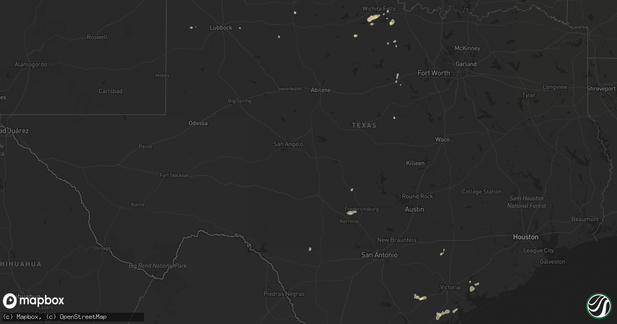
Hail Map in Texas on July 31, 2015
Get this storm
July 31 map
$229
one time, instant access
Download today. No call, no setup
Keep the $229
Bought the map and want the full workflow? Apply the entire $229 to a subscription within 7 days. None of it is wasted.
Every map, not just this one
This buys you this map. Subscription and you get every map we run, in the markets you choose from a few cities to whole states to nationwide. Plus real-time alerts the moment a storm fires.
Contact data
Name, contact info, occupancy, even credit band for addresses in the footprint. You go from where it hit to who to call.
Become the source they trust
Unlimited branding weather history reports on demand. You already have the documented answer ready for the property owner, and you are the one who showed up with it.
Property data and RoofTrace estimates
Pull up any address you have got, its value and the exact code rules for that jurisdiction, straight from One Click Code. Then RoofTrace estimates the squares, pitch, and roof value, priced the way you price.
Storm reports in Texas
Texas
| Date | Description |
|---|---|
| 07/31/20156:41 PM CDT | Large carport blown onto power lines and power poles blown onto road near intersection of staples and ayers. Time estimated from radar. |
| 07/31/20152:55 PM CDT | A local report indicates 58 MPH wind near 5 N VERNON |
| 07/30/20159:58 PM CDT | Report received via kvii schoolnet. |
| 07/30/20159:15 PM CDT | Report via west texas mesonet. |
All States Impacted by Hail Map on July 31, 2015
Cities Impacted by Hail Map on July 31, 2015
- Tipton, OK
- Frederick, OK
- Levelland, TX
- Syracuse, NE
- Otoe, NE
- Clarks, NE
- Central City, NE
- Fullerton, NE
- Genoa, NE
- Albion, NE
- Saint Edward, NE
- Farwell, NE
- Elba, NE
- Clarkson, NE
- Howells, NE
- Saint Paul, NE
- Ainsworth, NE
- Bassett, NE
- Long Pine, NE
- Weeping Water, NE
- Nehawka, NE
- Adams, NE
- Cortland, NE
- Firth, NE
- Guide Rock, NE
- West Point, NE
- Oakland, NE
- Bartlett, NE
- Ericson, NE
- Dunbar, NE
- Wasta, SD
- York, NE
- Bradshaw, NE
- Polk, NE
- Stromsburg, NE
- Benedict, NE
- Canyon, TX
- Wildorado, TX
- Hereford, TX
- Tivoli, TX
- Stanton, NE
- Mission, SD
- Prescott, IA
- Juniata, NE
- Maryville, MO
- Anselmo, NE
- Sutton, NE
- Opp, AL
- Mountain View, OK
- Hico, TX
- Carlton, TX
- Lipan, TX
- Brashear, MO
- Greentop, MO
- Burwell, NE
- Lumpkin, GA
- Wood River, NE
- Wichita Falls, TX
- Holliday, TX
- Johnstown, NE
- White River, SD
- Rocky Ford, GA
- Talmage, NE
- Ralls, TX
- Elk City, OK
- Canute, OK
- Headrick, OK
- Gulf Shores, AL
- Foley, AL
- Bon Secour, AL
- Malvern, IA
- Silver City, IA
- Hastings, IA
- Atkinson, NE
- Amelia, NE
- Stuart, NE
- Newport, NE
- Chambers, NE
- Pensacola, FL
- Vienna, GA
- Unadilla, GA
- Scotia, NE
- Wolbach, NE
- Greeley, NE
- Diagonal, IA
- Newman Grove, NE
- Roseland, NE
- Dodge, NE
- Primrose, NE
- Mineral Wells, TX
- Tarkio, MO
- Sargent, NE
- Spalding, NE
- Imogene, IA
- Emerson, IA
- Hurdland, MO
- Kellerton, IA
- Lamoni, IA
- Mount Ayr, IA
- Hamilton, GA
- Pine Mountain Valley, GA
- Pine Mountain, GA
- Maxwell, NE
- Harvard, NE
- Westboro, MO
- Elmo, MO
- Burlington Junction, MO
- Burr, NE
- Unadilla, NE
- Springview, NE
- Tekamah, NE
- Craig, NE
- Hooper, NE
- Herman, NE
- Grand Island, NE
- Phillips, NE
- Chapman, NE
- Aurora, NE
- Marquette, NE
- Boynton Beach, FL
- Comstock, NE
- Barnard, MO
- Ravenwood, MO
- Conchas Dam, NM
- Superior, NE
- Mankato, KS
- Cordell, OK
- Millen, GA
- Pickrell, NE
- Parnell, MO
- Benton, IA
- Clearfield, IA
- Lenox, IA
- Nebraska City, NE
- Sparks, NE
- Palmer, NE
- Madison, NE
- Homestead, FL
- Miami, FL
- Avoca, NE
- Villisca, IA
- Nodaway, IA
- Fort Lauderdale, FL
- Belgrade, NE
- Fort Benning, GA
- Petersburg, NE
- Cedar Rapids, NE
- Hordville, NE
- Silver Creek, NE
- Conception Junction, MO
- Murdock, NE
- Alvo, NE
- Blanchard, IA
- Blakely, GA
- Gallup, NM
- Ord, NE
- Guyton, GA
- Ellabell, GA
- Skidmore, MO
- Pickering, MO
- Blockton, IA
- Bedford, IA
- Valentine, NE
- Henderson, NE
- Hampton, NE
- Grafton, NE
- Creston, NE
- Jeffersonville, GA
- Danville, GA
- Cochran, GA
- Nesmith, SC
- Hemingway, SC
- Bartley, NE
- Corning, IA
- Palmyra, NE
- Henrietta, TX
- Fredericksburg, TX
- Kerrville, TX
- Goliad, TX
- Doniphan, NE
- Paducah, TX
- Seymour, TX
- Baring, MO
- Archer, NE
- Saint Libory, NE
- Cordele, GA
- Refugio, TX
- Enterprise, AL
- Cheyenne, OK
- Crawford, OK
- Ash, NC
- Shiner, TX
- Watson, MO
- Rock Port, MO
- Trumbull, NE
- Alda, NE
- East Dublin, GA
- Inland, NE
- Laramie, WY
- Bellevue, TX
- Hildale, UT
- Fort Cobb, OK
- Anadarko, OK
- Rincon, GA
- Springfield, GA
- Nakina, NC
- Jacksboro, TX
- Bryson, TX
- Woodsboro, TX
- Apache, OK
- Supply, NC
- Leigh, NE
- Humphrey, NE
- Wisner, NE
- Lindsay, NE
- Moulton, TX
- Clyde, MO
- Conception, MO
- Guilford, MO
- Stanberry, MO
- Sheridan, MO
- Giltner, NE
- Shelby, NE
- Gracemont, OK
- Cheyenne, WY
- Austwell, TX
- Hardeeville, SC
- Ridgeland, SC
- Indiantown, FL
- Baker, FL
- Broken Bow, NE
- Monticello, MO
- Lewistown, MO
- Laurel Hill, FL
- Gordon, GA
- Leland, NC
- Belvidere, SD
- New Brockton, AL
- Santo, TX
- Elberta, AL
- Lolita, TX
- Clayton, AL
- Louisville, AL
- Girard, TX
- Robertsdale, AL
- Irwinton, GA
- Pinehurst, GA
- Molino, FL
- Downing, MO
- Vernon, FL
- Gresham, NE
- Hollywood, FL
- Tucumcari, NM
- Lone Wolf, OK
- Electra, TX
- Harrold, TX
- Junction City, GA
- Byron, GA
- Fort Valley, GA
- Wrightsville, GA
- Tennille, GA
- Eagle, NE
- Newkirk, NM
- Statesboro, GA
- Leedey, OK
- Florala, AL
- Lebanon, NE
- Custer City, OK
- Archer City, TX
- Mason, TX
- Hawkinsville, GA
- Osceola, NE
- Millsap, TX
- Winner, SD
- Adrian, GA
- Uvalde, TX
- Long Valley, SD
- Savannah, MO
- Yukon, OK
- El Reno, OK
- Piedmont, OK
- Lorton, NE
- Murray, NE
- Warm Springs, GA
- Conway, SC
- Kinston, AL
- Elba, AL


