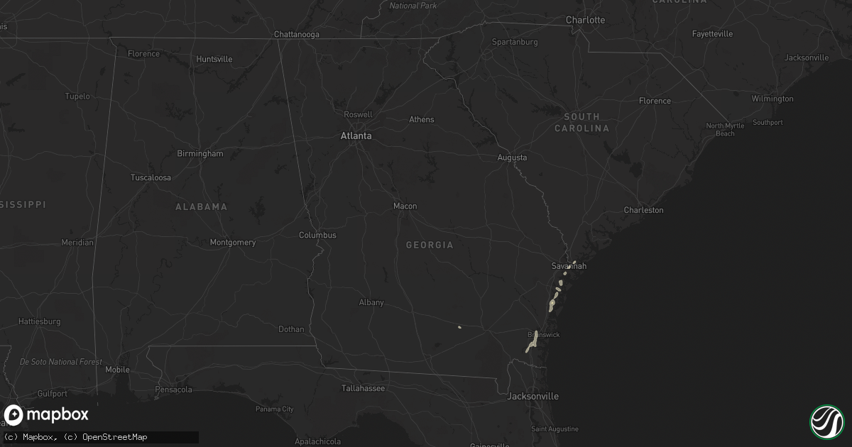
Hail Map in Georgia on July 27, 2018
Get this storm
July 27 map
$229
one time, instant access
Download today. No call, no setup
Keep the $229
Bought the map and want the full workflow? Apply the entire $229 to a subscription within 7 days. None of it is wasted.
Every map, not just this one
This buys you this map. Subscription and you get every map we run, in the markets you choose from a few cities to whole states to nationwide. Plus real-time alerts the moment a storm fires.
Contact data
Name, contact info, occupancy, even credit band for addresses in the footprint. You go from where it hit to who to call.
Become the source they trust
Unlimited branding weather history reports on demand. You already have the documented answer ready for the property owner, and you are the one who showed up with it.
Property data and RoofTrace estimates
Pull up any address you have got, its value and the exact code rules for that jurisdiction, straight from One Click Code. Then RoofTrace estimates the squares, pitch, and roof value, priced the way you price.
Storm reports in Georgia
Georgia
| Date | Description |
|---|---|
| 07/27/20182:56 PM CDT | Severe roof damage at marshpoint elementary school. Time estimated based on radar. |
| 07/27/20182:54 PM CDT | Powerlines down on oatland island. Time estimated based on radar. |
| 07/27/201812:40 AM CDT | At 540 PM EDT, a severe thunderstorm was located over Dock Junction, moving southeast at 10 mph. HAZARD...60 mph wind gusts and penny size hail. SOURCE...Radar indicated. IMPACT...Expect damage to roofs, siding, and trees. Locations impacted include... Brunswick, St. Simons Island, Dock Junction, Country Club Estates, Sea Island, Jekyll Island and Boys Estate. |
| 07/27/201812:05 AM CDT | At 505 PM EDT, severe thunderstorms were located along a line extending from 20 miles east of Tibet to near Darien, moving south at 15 mph. HAZARD...60 mph wind gusts and penny size hail. SOURCE...Radar indicated. IMPACT...Expect damage to trees and powerlines. Locations impacted include... Darien, Wolf Island, Harris Neck, Valona, Little Saint Simons Island, Meridian, Crescent and Carnigan.This warning includes I-95 in Georgia between mile markers 50 and 57. |
| 07/26/201811:21 PM CDT | At 421 PM EDT, a severe thunderstorm was located near Ty Ty, or near Tifton, moving east at 25 mph. HAZARD...60 mph wind gusts. SOURCE...Radar indicated. IMPACT...Expect damage to roofs, siding, and trees. Locations impacted include... Tifton, Nashville, Enigma, Omega, Lenox, Ty Ty, Alapaha, Unionville, Phillipsburg, Eldorado, Scooterville, Gladys, Glory, Wagon Wheel, Weber, Vanceville, Cottle, Hillsdale, Staunton and Berrien Co A/P. |
All States Impacted by Hail Map on July 27, 2018
Cities Impacted by Hail Map on July 27, 2018
- Waterville, NY
- Bouckville, NY
- Madison, NY
- Cassville, NY
- Clayville, NY
- Sauquoit, NY
- Oriskany Falls, NY
- Woodstock, NY
- Shokan, NY
- Bearsville, NY
- Glenford, NY
- Kaycee, WY
- Hill City, SD
- Canon City, CO
- Florence, CO
- Cotopaxi, CO
- Bridger, MT
- Wray, CO
- Holyoke, CO
- Cheyenne, WY
- Carr, CO
- Lead, SD
- Brooklyn, MD
- Halethorpe, MD
- Baltimore, MD
- Grundy, VA
- Oakwood, VA
- Townsend, GA
- Schuyler, NE
- Lindsay, NE
- Oakdale, NE
- Humphrey, NE
- Platte Center, NE
- Battle Creek, NE
- Columbus, NE
- Creston, NE
- Meadow Grove, NE
- Neligh, NE
- Madison, NE
- Tilden, NE
- Newman Grove, NE
- Bellwood, NE
- Walsenburg, CO
- Cornville, AZ
- Crookston, NE
- Deer Trail, CO
- Byers, CO
- Strasburg, CO
- Leigh, NE
- Flagler, CO
- Seibert, CO
- Anton, CO
- Cope, CO
- Aladdin, WY
- Deer Lodge, MT
- Bingham, NE
- Rushville, NE
- Batesland, SD
- Gordon, NE
- Pine Ridge, SD
- Oglala, SD
- Goodland, KS
- Spearville, KS
- Labelle, FL
- Frostproof, FL
- Kinsley, KS
- Hanston, KS
- Offerle, KS
- Ness City, KS
- Leoti, KS
- Watervliet, NY
- Cohoes, NY
- Albany, NY
- Latham, NY
- Troy, NY
- Hulett, WY
- Nemo, SD
- Saint Onge, SD
- Spearfish, SD
- Sturgis, SD
- Beulah, WY
- Alzada, MT
- Rapid City, SD
- Whitewood, SD
- Sundance, WY
- Deadwood, SD
- Belle Fourche, SD
- Haigler, NE
- Kiowa, CO
- Elizabeth, CO
- Kit Carson, CO
- Wolf, WY
- Ranchester, WY
- Wyola, MT
- Sheridan, WY
- Dayton, WY
- Parkman, WY
- Rozel, KS
- Wallace, KS
- Onancock, VA
- Wetmore, CO
- Pueblo, CO
- Rye, CO
- Beulah, CO
- Blenheim, SC
- Tucson, AZ
- King George, VA
- Colonial Beach, VA
- Issue, MD
- Buffalo Creek, CO
- Pine, CO
- Orchard, CO
- Kersey, CO
- Newcastle, WY
- Ovid, CO
- Crook, CO
- Haxtun, CO
- Edson, KS
- Sidney, NE
- Gurley, NE
- Sedgwick, CO
- Winona, KS
- Paoli, CO
- Julesburg, CO
- Lodgepole, NE
- Saint Francis, KS
- Boulder, MT
- Oxford, ME
- Minot, ME
- Hebron, ME
- Turner, ME
- South Paris, ME
- Auburn, ME
- Woodrow, CO
- Powhatan, VA
- Karthaus, PA
- Buffalo, WY
- Bozeman, MT
- Darien, GA
- Sheridan Lake, CO
- Maxton, NC
- Coldwater, KS
- La Crosse, KS
- Larned, KS
- Rush Center, KS
- Bison, KS
- Hays, KS
- Billings, MT
- Stapleton, NE
- Liebenthal, KS
- Schoenchen, KS
- McCracken, KS
- Ellis, KS
- Douglas, WY
- Hugo, CO
- Karval, CO
- Church Road, VA
- Sutherland, VA
- Bucklin, KS
- Minneola, KS
- Mullinville, KS
- Hall, MT
- Flagstaff, AZ
- Dover Plains, NY
- Wiggins, CO
- Roggen, CO
- Deltona, FL
- Buckfield, ME
- Glenrock, WY
- Otis, KS
- Fromberg, MT
- Lodge Grass, MT
- Roberts, MT
- Reed Point, MT
- Big Timber, MT
- Joliet, MT
- Greycliff, MT
- Columbus, MT
- Molt, MT
- Broadview, MT
- Dunning, NE
- Hermosa, SD
- Ashby, NE
- Keystone, SD
- Merriman, NE
- Fairburn, SD
- Buffalo Gap, SD
- Kearny, AZ
- Glen Arm, MD
- Schenectady, NY
- Torrington, WY
- Nathrop, CO
- Salida, CO
- Bogue, KS
- Damar, KS
- Plainville, KS
- Palco, KS
- Gold Creek, MT
- Drummond, MT
- Burdett, KS
- Saint Francis, SD
- Jacksonville, FL
- Bryceville, FL
- Young, AZ
- Holly, CO
- Halsey, NE
- Arnold, NE
- Purdum, NE
- Guilderland, NY
- Slingerlands, NY
- Waterford, NY
- Voorheesville, NY
- Story, WY
- Frederick, MD
- Ford, KS
- Damascus, PA
- Protection, KS
- Osage, WY
- Jarratt, VA
- Emporia, VA
- Walkersville, MD
- Bluffton, SC
- Lancaster, VA
- Imperial, NE
- Cubero, NM
- Brunswick, GA
- Waverly, GA
- Woodbine, GA
- Jetmore, KS
- Macon, NC
- Littleton, NC
- White Plains, VA
- Ebony, VA
- Saint Xavier, MT
- Belgrade, MT
- Gillette, WY
- Ashland, KS
- Lottsburg, VA
- Scotland, MD
- Sedona, AZ
- Divide, CO
- Durant, OK
- Madill, OK
- Kenefic, OK
- Custer, SD
- Eads, CO
- Carrsville, VA
- Franklin, VA
- Zuni, VA
- Sedley, VA
- Courtland, VA
- Suffolk, VA
- Ivor, VA
- Odenton, MD
- Parkville, MD
- Severn, MD
- Fork, MD
- Linthicum Heights, MD
- Elkridge, MD
- Baldwin, MD
- Harmans, MD
- Hydes, MD
- Fallston, MD
- Joppa, MD
- Abingdon, MD
- Catonsville, MD
- Gwynn Oak, MD
- Kingsville, MD
- Hanover, MD
- Ellicott City, MD
- Glen Burnie, MD
- Towson, MD
- Pikesville, MD
- Fort George G Meade, MD
- Bel Air, MD
- McKenney, VA
- Dewitt, VA
- Ford, VA
- Wilsons, VA
- Rolla, KS
- Guymon, OK
- Goodwell, OK
- Chesterfield, VA
- Arriba, CO
- Lindon, CO
- Agate, CO
- Genoa, CO
- Clewiston, FL
- Payson, AZ
- Garrett, WY
- Clearmont, WY
- Banner, WY
- Colorado City, CO
- Mays Landing, NJ
- Vineland, NJ
- Milmay, NJ
- Richland, NJ
- Buena, NJ
- Thermopolis, WY
- Cottonwood, AZ
- Grant, NE
- Westcliffe, CO
- Avondale, CO
- Valentine, NE
- Haviland, KS
- Laramie, WY
- Buford, WY
- Albuquerque, NM
- Wynantskill, NY
- Whitehall, MT
- Lovell, WY
- Rosedale, MD
- Nottingham, MD
- Shawnee, WY
- Evergreen, CO
- Conifer, CO
- Camp Verde, AZ
- Kilmarnock, VA
- Ijamsville, MD
- New Market, MD
- Monrovia, MD
- Idalia, CO
- Kanorado, KS
- Bunnell, FL
- Kinderhook, NY
- Thedford, NE
- Savannah, GA
- Evansville, WY
- Sharon Springs, KS
- Norlina, NC
- Manson, NC
- Morrill, NE
- Warrenton, NC
- Fleetwood, PA
- Alburtis, PA
- Mertztown, PA
- Mechanicville, NY
- Ballston Lake, NY
- Dahlgren, VA
- Casper, WY
- Montross, VA
- Franktown, CO
- Moshannon, PA
- Spring Lake, NC
- Lillington, NC
- Bunnlevel, NC
- Naples, FL
- Leonardsville, NY
- West Edmeston, NY
- Richfield Springs, NY
- West Winfield, NY
- Fowler, CO
- Mission, SD
- Richmond, VA
- Chester, VA
- Looneyville, WV
- Newton, WV
- Limon, CO
- Glenmont, NY
- Castleton On Hudson, NY
- Selkirk, NY
- East Greenbush, NY
- Rensselaer, NY
- Red Springs, NC
- Lake Mary, FL
- Longwood, FL
- Stafford, VA
- Skippers, VA
- Drewryville, VA
- Capron, VA
- Hot Springs, SD
- Cardwell, MT
- Acton, MT
- Vero Beach, FL
- Bazine, KS
- Charlottesville, VA
- Reisterstown, MD
- Immokalee, FL
- Vona, CO
- Lakeside, AZ
- Charlotte Court House, VA
- Cullen, VA
- Plainview, NE
- Woodstock, MD
- Marriottsville, MD
- Sykesville, MD
- Bracey, VA
- Boydton, VA
- Deerfield, KS
- Midway, GA
- Altamont, NY
- Ilion, NY
- Morrisville, NY
- Deansboro, NY
- Frankfort, NY
- Hubbardsville, NY
- Butte, MT
- Axson, GA
- Delmar, NY
- Rexford, NY
- Clifton Park, NY
- Miami, AZ
- Williamsburg, VA
- Morrison, CO
- Elloree, SC
- Steep Falls, ME
- Garden City, KS
- Pringle, SD
- Whitman, NE
- Windsor Mill, MD
- Owings Mills, MD
- Randallstown, MD
- Dothan, AL
- Linden, NC
- Gloucester, VA
- Winifrede, WV
- Hernshaw, WV
- Cabin Creek, WV
- Eskdale, WV
- Drybranch, WV
- Gallagher, WV
- Miami, WV
- Bowman, SC
- Lamar, CO
- Granada, CO
- Bennett, CO
- Santee, SC
- Standish, ME
- Valley Falls, NY
- Venus, FL
- Richmond Hill, GA
- Melville, MT
- Averill Park, NY
- Seaboard, NC
- Margarettsville, NC
- Garysburg, NC
- Jackson, NC
- Howe, OK
- Heavener, OK
- Ojo Caliente, NM
- Johnstown, NE
- Lake Placid, FL
- Okeechobee, FL
- Yale, VA
- Stony Creek, VA
- Sanford, FL
- Poquoson, VA
- Hampton, VA
- Yorktown, VA
- Ellsworth, NE
- Bailey, CO
- Wheatland, WY


