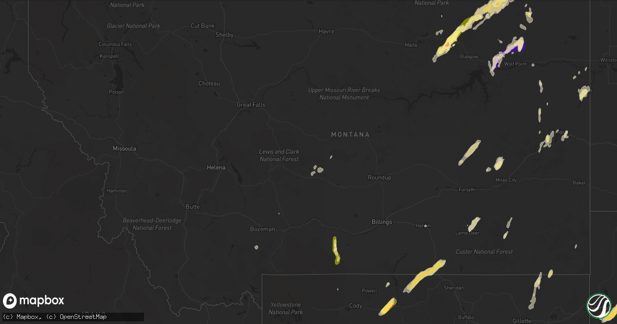
Hail Map in Montana on July 27, 2015
Get this storm
July 27 map
$229
one time, instant access
Download today. No call, no setup
Keep the $229
Bought the map and want the full workflow? Apply the entire $229 to a subscription within 7 days. None of it is wasted.
Every map, not just this one
This buys you this map. Subscription and you get every map we run, in the markets you choose from a few cities to whole states to nationwide. Plus real-time alerts the moment a storm fires.
Contact data
Name, contact info, occupancy, even credit band for addresses in the footprint. You go from where it hit to who to call.
Become the source they trust
Unlimited branding weather history reports on demand. You already have the documented answer ready for the property owner, and you are the one who showed up with it.
Property data and RoofTrace estimates
Pull up any address you have got, its value and the exact code rules for that jurisdiction, straight from One Click Code. Then RoofTrace estimates the squares, pitch, and roof value, priced the way you price.
Storm reports in Montana
Montana
| Date | Description |
|---|---|
| 07/27/20156:55 PM CDT | Mainly nickel sized hail with some quarter sized covering the ground white...heavy rain and estimated wind gust 30 to 40 mph. |
| 07/27/20156:53 PM CDT | A local report indicates 1.25 inch wind near 20 NW MILES CITY |
| 07/27/20156:15 PM CDT | A local report indicates 61 MPH wind near 1 SSE BAKER |
| 07/27/20156:10 PM CDT | Public reported a tree down due to strong thunderstorm winds. |
| 07/27/20155:45 PM CDT | Spotter reported 60 mph winds and downed tree limbs. |
| 07/27/20154:31 PM CDT | Spotter estimated 60mph thunderstorm wind gusts. |
| 07/27/20153:42 PM CDT | Spotter reported quarter size hail. |
| 07/26/201510:12 PM CDT | A local report indicates 70 MPH wind near 2 NE GLENDIVE |
| 07/26/201510:03 PM CDT | A local report indicates 60 MPH wind near 1 ENE WIBAUX |
| 07/26/20159:52 PM CDT | A local report indicates 64 MPH wind near 10 WSW WESTBY |
| 07/26/20159:35 PM CDT | With heavy rain. |
| 07/26/20159:33 PM CDT | A local report indicates 85 MPH wind near 2 W MEDICINE LAKE |
| 07/26/20159:29 PM CDT | A local report indicates 58 MPH wind near 1 SSE BAKER |
| 07/26/20159:22 PM CDT | A local report indicates 66 MPH wind near 1 SSE BAKER |
| 07/26/20159:18 PM CDT | A local report indicates 66 MPH wind near 1 SSE BAKER |
| 07/26/20159:15 PM CDT | A local report indicates 63 MPH wind near 8 SE FROID |
| 07/26/20159:04 PM CDT | Sustained 46 with gust to 60 mph. |
| 07/26/20159:04 PM CDT | Sustained 46 with gust to 60 mph. |
| 07/26/20159:00 PM CDT | With rain...no hail reported. |
| 07/26/20158:53 PM CDT | A local report indicates 63 MPH wind near 3 WNW MILES CITY |
| 07/26/20158:50 PM CDT | A local report indicates 64 MPH wind near 3 WNW MILES CITY |
| 07/26/20158:49 PM CDT | Trained spotter witnessed many roof shingles being blown off. |
| 07/26/20158:45 PM CDT | A local report indicates 62 MPH wind near 2 NW ROCK SPRINGS |
| 07/26/20158:37 PM CDT | Estimated 50 to 60 mph wind gust...blew roof off old shed. |
| 07/26/20158:36 PM CDT | A local report indicates 75 MPH wind near 3 WNW MILES CITY |
| 07/26/20158:36 PM CDT | 12-18 inch diameter trees snapped and power lines down in miles city. |
| 07/26/20158:34 PM CDT | Gust 60 to 65 mph. |
| 07/26/20158:32 PM CDT | A local report indicates 72 MPH wind near 4 N OSWEGO |
| 07/26/20158:30 PM CDT | Occurred between 730 and 8 pm...with heavy rain. |
| 07/26/20158:20 PM CDT | Observer estimated the he had wind gust to 60 mph. |
| 07/26/20158:20 PM CDT | A local report indicates 1.00 inch wind near SIDNEY |
| 07/26/20158:20 PM CDT | Also had heavy rain. |
| 07/26/20158:15 PM CDT | Estimated 80 mph winds damaged buildings and tipped over grain bins. |
| 07/26/20158:06 PM CDT | A local report indicates 75 MPH wind near 7 ESE BLOOMFIELD |
| 07/26/20157:50 PM CDT | From the glendive airport...time estimated due to anemometer blowing off during 90 mph wind gust. |
| 07/26/20157:45 PM CDT | A local report indicates 65 MPH wind near 5 NNE HOYT |
| 07/26/20157:40 PM CDT | Open front end pole barn blown apart...older building moved off its foundation...tree limbs 5 to 6 inches broken. |
| 07/26/20157:25 PM CDT | 1 inch hail fell for 20 minutes. Hail 3 inches deep on the ground. |
| 07/26/20157:02 PM CDT | Mainly dime sized hail with some golf ball sized with heavy rain and estimated wind gust 40 mph. |
All States Impacted by Hail Map on July 27, 2015
Cities Impacted by Hail Map on July 27, 2015
- Wagner, SD
- Newcastle, WY
- Richey, MT
- Greybull, WY
- Burlington, WY
- Clear Lake, MN
- Foley, MN
- Lusk, WY
- Harrison, NE
- Edgemont, SD
- Hill City, SD
- Faith, SD
- Otter, MT
- Lead, SD
- Taunton, MN
- Audubon, IA
- Manning, IA
- Manilla, IA
- Irwin, IA
- Hyannis, NE
- Roseland, VA
- Arrington, VA
- Amherst, VA
- Sturgis, SD
- Craig, NE
- Arlington, NE
- Winslow, NE
- Tekamah, NE
- Herman, NE
- Hooper, NE
- Rockville, VA
- Henrico, VA
- Glen Allen, VA
- Custer, SD
- Gary, SD
- Sloan, IA
- Russell, MA
- Blandford, MA
- Arco, MN
- Lake Benton, MN
- Butte, NE
- Naper, NE
- Fairfax, SD
- Bonesteel, SD
- Oshkosh, NE
- Lisco, NE
- Lewellen, NE
- Dallas, SD
- Kinsey, MT
- Ashley, ND
- Crozier, VA
- Oilville, VA
- Manakin Sabot, VA
- Hulett, WY
- Alzada, MT
- Presho, SD
- Peru, NY
- Morrill, NE
- Pukwana, SD
- Kimball, SD
- Hot Springs, SD
- Tappen, ND
- Medina, ND
- Laurel, NE
- Carroll, NE
- Peterborough, NH
- Union Center, SD
- Gering, NE
- White Lake, SD
- Frazer, MT
- Revillo, SD
- Centerville, IA
- Plano, IA
- Mystic, IA
- Seymour, IA
- Promise City, IA
- Holden, ME
- Ellsworth, ME
- Eddington, ME
- Melrose, MN
- Freeport, MN
- Porcupine, SD
- Draper, SD
- Allen, SD
- Kyle, SD
- Murdo, SD
- Wood, SD
- Winner, SD
- Okaton, SD
- White River, SD
- Ideal, SD
- Vivian, SD
- Martin, SD
- Wanblee, SD
- Long Valley, SD
- Norris, SD
- Mullen, NE
- Valentine, NE
- Glendive, MT
- Rapid City, SD
- Keystone, SD
- Dakota City, NE
- Sioux City, IA
- South Sioux City, NE
- New Underwood, SD
- Tyro, VA
- Forsyth, MT
- North Bend, NE
- Deadwood, SD
- Boyden, IA
- George, IA
- Hull, IA
- Chamberlain, SD
- Oacoma, SD
- Kennebec, SD
- Truro, IA
- Creighton, NE
- Hinsdale, MT
- Whiting, IA
- Glentana, MT
- Richland, MT
- Peerless, MT
- Opheim, MT
- Lake Andes, SD
- Dupree, SD
- Harrold, SD
- Madison, MN
- Dawson, MN
- Canby, MN
- Fort Peck, MT
- Chester, SD
- Hermosa, SD
- Buffalo Gap, SD
- Fairburn, SD
- Cherry Creek, SD
- Vega, TX
- Lakeside, NE
- Ellsworth, NE
- Mitchell, NE
- Scottsbluff, NE
- Hamill, SD
- Mapleton, IA
- New Ipswich, NH
- Greenville, NH
- Lodge Grass, MT
- Lovell, WY
- Dayton, WY
- Wyola, MT
- Parkman, WY
- Wolf Point, MT
- Niobrara, NE
- Lyman, NE
- Yoder, WY
- Hawk Springs, WY
- Bradley, SD
- Colton, SD
- Montrose, SD
- Humboldt, SD
- Hartford, SD
- Rockwood, ME
- Greenville, ME
- Gillette, WY
- Rozet, WY
- Weston, WY
- Atkinson, NE
- Bloomfield, MT
- Lindsay, MT
- Marietta, MN
- Meriden, IA
- Cleghorn, IA
- Marcus, IA
- Ruthton, MN
- Pipestone, MN
- Saint Onge, SD
- Spearfish, SD
- Ree Heights, SD
- Glasgow, MT
- Willow Lake, SD
- Minatare, NE
- Rock Rapids, IA
- Verdigre, NE
- Onawa, IA
- Doon, IA
- Steele, ND
- Box Elder, SD
- Kingsley, IA
- Colome, SD
- Coleridge, NE
- Allen, NE
- Dixon, NE
- Hartington, NE
- Wayne, NE
- Ponca, NE
- Newcastle, NE
- Eureka, SD
- Cohagen, MT
- Smithwick, SD
- Batesland, SD
- Wounded Knee, SD
- Sartell, MN
- Saint Joseph, MN
- Rice, MN
- Saint Stephen, MN
- Orchard, NE
- Page, NE
- Crofton, NE
- Springfield, SD
- Bloomfield, NE
- Oneill, NE
- Wausa, NE
- Winnetoon, NE
- Ames, NE
- Mondamin, IA
- Pisgah, IA
- Little Sioux, IA
- Fremont, NE
- Blair, NE
- Scribner, NE
- Nickerson, NE
- Buncombe, IL
- Goreville, IL
- Gregory, SD
- Sergeant Bluff, IA
- Lawton, IA
- Fairview, MT
- Hoskins, NE
- Norfolk, NE
- Roscoe, MT
- Fishtail, MT
- Absarokee, MT
- Red Lodge, MT
- Kirkman, IA
- Lehr, ND
- Anabel, MO
- Shelbyville, MO
- Clarence, MO
- Lentner, MO
- Newell, SD
- Sidney, MT
- Peever, SD
- Gann Valley, SD
- Scobey, MT
- Pine Ridge, SD
- Corning, IA
- Belle Fourche, SD
- Eagle Butte, SD
- Orange City, IA
- La Plata, MO
- Vermillion, SD
- Gayville, SD
- Vinton, VA
- Mound City, SD
- Java, SD
- Houghton, SD
- Ashland, VA
- Richmond, VA
- Mechanicsville, VA
- Hanover, VA
- Exira, IA
- Guthrie Center, IA
- Adair, IA
- Ivanhoe, MN
- Porter, MN
- Elsmere, NE
- Johnstown, NE
- Ashby, NE
- Center Tuftonboro, NH
- Mirror Lake, NH
- Coon Rapids, IA
- Hamlin, IA
- Kimballton, IA
- Bayard, IA
- Elk Horn, IA
- Gray, IA
- Howes, SD
- Elizabethtown, NY
- Lewis, NY
- Holstein, IA
- Cushing, IA
- Raymond, SD
- Fort Stockton, TX
- Lynch, NE
- Pender, NE
- Churdan, IA
- Holabird, SD
- Bremo Bluff, VA
- Arthur, NE
- Oskaloosa, IA
- Rosebud, MT
- Thedford, NE
- Timber Lake, SD
- Dexter, IA
- Minneota, MN
- Boyd, MN
- Streeter, ND
- Gackle, ND
- Earlysville, VA
- Bronson, IA
- North Sioux City, SD
- Watson, MN
- Montevideo, MN
- Lemmon, SD
- Remsen, IA
- David City, NE
- Oral, SD
- Seneca, SD
- Castana, IA
- Earling, IA
- Dunlap, IA
- Bayard, NE
- Two Dot, MT
- Judith Gap, MT
- Nemo, SD
- Volborg, MT
- Mud Butte, SD
- Vale, SD
- Fort Meade, SD
- Whitewood, SD
- Bristow, NE
- Westside, IA
- Fallon, MT
- Manderson, WY
- Templeton, IA
- Temple, NH
- Wilton, NH
- Wasta, SD
- Owanka, SD
- Wall, SD
- Redfield, IA
- Earlham, IA
- Macon, MO
- Atlanta, MO
- Burke, SD
- Saco, MT
- Lyons, NE
- Bancroft, NE
- Rosalie, NE
- New Athens, IL
- Freeburg, IL
- Sparta, IL
- Marissa, IL
- Melbeta, NE
- Bridgeport, NE
- Hinton, IA
- Hornick, IA
- Soldier, IA
- Ute, IA
- Nashua, MT
- Adel, IA
- Dallas Center, IA
- Minburn, IA
- Linden, IA
- Perry, IA
- Yale, IA
- Panora, IA
- Clark, SD
- Whitman, NE
- Saint Lawrence, SD
- Rockham, SD
- Miller, SD
- Granville, IA
- Elkton, SD
- Torrington, WY
- Goshen, MA
- Milan, MN
- Winchester, NH
- Lame Deer, MT
- Lodgepole, NE
- Scotland, SD
- Tyndall, SD
- Tabor, SD
- Winnebago, NE
- Emerson, NE
- Hubbard, NE
- Homer, NE
- Harrington, ME
- Zeeland, ND
- Walthill, NE
- Thurston, NE
- Parmelee, SD
- Middletown, VA
- Front Royal, VA
- Shelbina, MO
- Marble Hill, MO
- Tamaroa, IL
- Pinckneyville, IL
- Moville, IA
- Spencer, NE
- Tyler, MN
- Colon, NE
- Cedar Bluffs, NE
- Savage, MT
- Crane, MT
- Myrtle, MO
- Ravenden, AR
- Couch, MO
- Millstadt, IL
- Reston, VA
- Oakton, VA
- Scenic, SD
- Utica, SD
- Irene, SD
- Meadow, SD
- Canton, SD
- Hendricks, MN
- Larslan, MT
- Burbank, SD
- Beresford, SD
- Tracy, IA
- Bussey, IA
- Harvey, IA
- Highmore, SD
- Rockwood, IL
- Cheyenne, WY
- Ashton, IA
- Sheldon, IA
- Clarkfield, MN
- Paris, MO
- Westport, SD
- Barnard, SD
- Clive, IA
- West Des Moines, IA
- Waukee, IA
- Lesterville, SD
- Stoutsville, MO
- Jackson, NE
- Jefferson, SD
- Seneca, NE
- Decatur, NE
- Wishek, ND
- Flaxville, MT
- Merrill, IA
- Enning, SD
- Carpenter, SD
- Smithton, IL
- Belleville, IL
- Gallatin Gateway, MT
- Bingham, NE
- Bellwood, NE
- Sauk Rapids, MN
- Princeton, MN
- Saint Cloud, MN
- Clearwater, MN
- Wilsall, MT
- Pleasantville, IA
- Knoxville, IA
- Leola, SD
- Wakonda, SD
- Mission, SD
- Nashville, IL
- Yankton, SD
- Ida Grove, IA
- Battle Creek, IA
- Danbury, IA
- Colman, SD
- Jackson, MO
- Paullina, IA
- Piedmont, SD
- Black Hawk, SD
- Cherryfield, ME
- Creal Springs, IL
- Smithland, IA
- Anthon, IA
- Oto, IA
- Rodney, IA
- Charter Oak, IA
- Pilger, NE
- Tulare, SD
- Southampton, MA
- Easthampton, MA
- Cedar Falls, IA
- Glencross, SD
- White Owl, SD
- Denison, IA
- Bassett, NE
- Holdingford, MN
- Avon, MN
- Astoria, SD
- White, SD
- Cody, WY
- Broadwater, NE
- Macy, NE
- Dover Foxcroft, ME
- Annandale, MN
- South Haven, MN
- Centerville, SD
- Westfield, MA
- Hartland, MN
- Albert Lea, MN
- Salix, IA
- Climbing Hill, IA
- Correctionville, IA
- Le Mars, IA
- Skowhegan, ME
- Buffalo, SD
- Merriman, NE
- Lenox, IA
- Dow City, IA
- Midland, SD
- Mission Hill, SD
- Menlo, IA
- Ozark, IL
- Wilmot, SD
- Stuart, NE
- Reliance, SD
- Fifty Six, AR
- Cutler, IL
- Newport, NE
- Maple Lake, MN
- Monticello, MN
- Becker, MN
- Vail, IA
- Manchester, ME
- Readfield, ME
- Unionville, MO
- Green Castle, MO
- Green City, MO
- Harlan, IA
- Novinger, MO
- Florence, SD
- Henry, SD
- Redfield, SD
- Ashton, SD
- Platte, SD
- Crow Agency, MT
- Groton, SD
- Turton, SD
- Whitetail, MT
- Lenzburg, IL
- Dedham, IA
- Philip, SD
- Alton, IA
- Broadus, MT
- Saint Charles, SD
- Herrick, SD
- Alliance, NE
- Williston, ND
- Lewistown, MT
- Lennox, SD
- Worthing, SD
- Jamestown, ND
- Conde, SD
- Iroquois, SD
- Panama, IA
- Bowlus, MN
- Royalton, MN
- Albany, MN
- Basin, WY


