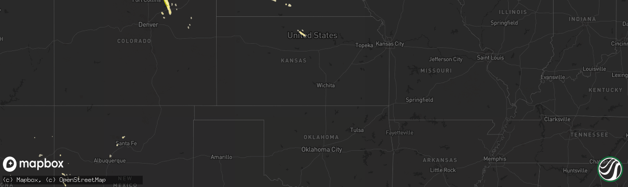
Hail Map in Wyoming on July 26, 2013
The weather event in Wyoming on July 26, 2013 includes Hail map. 16 states and 146 cities were impacted and suffered possible damage. The total estimated number of properties impacted is 29.
Want more than just the map?
Turn this storm into a full workflow.
- Owner + property data so you know who to knock
- OnDemand branded weather history reports to win the "did we even have hail?" argument
- RoofTrace estimate so reps stop guessing numbers at the door
Bought this map? Upgrade within 7 days and we'll credit the $230. (10-15 min setup call)
Hail
29
Estimated number of impacted properties by a 1.00" hail or larger44
Estimated number of impacted properties by a 1.75" hail or larger0
Estimated number of impacted properties by a 2.50" hail or largerStorm reports in Wyoming
Wyoming
| Date | Description |
|---|---|
| 07/26/20136:25 PM CDT | A local report indicates 1.25 inch wind near CHEYENNE |
| 07/26/20136:24 PM CDT | A local report indicates 1.50 inch wind near CHEYENNE |
| 07/26/20136:22 PM CDT | Very heavy rain |
| 07/26/20136:21 PM CDT | A local report indicates 1.25 inch wind near CHEYENNE |
| 07/26/20136:20 PM CDT | A local report indicates 1.50 inch wind near 1 E CHEYENNE |
| 07/26/20136:19 PM CDT | A local report indicates 1.75 inch wind near CHEYENNE |
| 07/26/20136:18 PM CDT | A local report indicates 1.75 inch wind near CHEYENNE |
| 07/26/20136:15 PM CDT | A local report indicates 1.00 inch wind near 4 E CHEYENNE |
| 07/26/20136:15 PM CDT | A local report indicates 1.00 inch wind near 2 E CHEYENNE |
| 07/26/20136:15 PM CDT | A local report indicates 2.00 inch wind near 10 N CHEYENNE |
| 07/26/20136:15 PM CDT | Falling at the nws office |
| 07/26/20136:14 PM CDT | A local report indicates 1.25 inch wind near 1 N CHEYENNE |
| 07/26/20136:13 PM CDT | A local report indicates 1.00 inch wind near CHEYENNE |
| 07/26/20136:12 PM CDT | A local report indicates 1.25 inch wind near 2 NW CHEYENNE |
| 07/26/20136:11 PM CDT | A local report indicates 1.00 inch wind near CHEYENNE |
| 07/26/20136:10 PM CDT | Vehicle windows shattered by hail at yellowstone and ridley road. |
| 07/26/20136:10 PM CDT | Vehicle windows shattered by hail at yellowstone and ridley road. |
| 07/26/20136:10 PM CDT | Vehicle windows shattered by hail at yellowstone and ridley road. |
| 07/26/20136:10 PM CDT | A local report indicates 1.00 inch wind near 5 ENE CHEYENNE |
| 07/26/20136:10 PM CDT | A local report indicates 1.25 inch wind near 2 NNW CHEYENNE |
| 07/26/20136:09 PM CDT | A local report indicates 1.75 inch wind near 4 NW CHEYENNE |
| 07/26/20136:08 PM CDT | Yellowstone and riding club road |
| 07/26/20136:05 PM CDT | A local report indicates 1.50 inch wind near CHEYENNE |
| 07/26/20136:04 PM CDT | A local report indicates 1.75 inch wind near 5 N CHEYENNE |
| 07/26/20136:03 PM CDT | A local report indicates 1.75 inch wind near 8 N CHEYENNE |
| 07/26/20135:59 PM CDT | A local report indicates 1.75 inch wind near 7 NW CHEYENNE |
| 07/26/20135:57 PM CDT | A local report indicates 1.00 inch wind near 12 N CHEYENNE |
| 07/26/20135:57 PM CDT | A local report indicates 2.00 inch wind near 10 N CHEYENNE |
| 07/26/20135:07 PM CDT | A local report indicates 1.00 inch wind near 7 NE CHEYENNE |
| 07/26/20134:57 PM CDT | A local report indicates 1.25 inch wind near 10 N CHEYENNE |
| 07/26/20134:55 PM CDT | A local report indicates 1.00 inch wind near 10 N CHEYENNE |
| 07/26/20134:45 PM CDT | Hail lasted 20 minutes. |
| 07/26/20134:45 PM CDT | Hail lasted 30 minutes. |
All States Impacted by Hail Map on July 26, 2013
Cities Impacted by Hail Map on July 26, 2013
- Nunn, CO
- Cheyenne, WY
- Gillett, WI
- Big Lake, TX
- Glen Elder, KS
- Coleman, TX
- Buckhorn, NM
- Juneau, WI
- Lowell, WI
- Beloit, KS
- Pie Town, NM
- Farmerville, LA
- Spearsville, LA
- Bernice, LA
- Quemado, NM
- Iraan, TX
- Chugwater, WY
- Broken Bow, OK
- Roggen, CO
- Keenesburg, CO
- Terrell, TX
- Kaufman, TX
- Wills Point, TX
- Elm Grove, LA
- Fort Morgan, CO
- Rentz, GA
- Colorado City, AZ
- Dawson, TX
- Bertrand, NE
- Loomis, NE
- Sonora, TX
- Smithfield, NE
- Fence Lake, NM
- Mansfield, LA
- Trinity Center, CA
- Upland, NE
- Minden, NE
- Wiggins, CO
- Weldona, CO
- Orchard, CO
- Peridot, AZ
- Marion, LA
- Briggsdale, CO
- Santa Fe, NM
- Williams, AZ
- Santa Clara, NM
- Weed, CA
- Gazelle, CA
- Deming, NM
- Ganado, AZ
- Upton, WY
- Suring, WI
- Bandera, TX
- Dike, TX
- Benson, AZ
- Pena Blanca, NM
- Columbus, WI
- Beaver Dam, WI
- Grover, CO
- Fe Warren Afb, WY
- Ault, CO
- Carr, CO
- Datil, NM
- Zwolle, LA
- Converse, LA
- Marathon, TX
- Albuquerque, NM
- Rio Rancho, NM
- Bernalillo, NM
- Corrales, NM
- Silver City, NM
- Arenas Valley, NM
- Sedona, AZ
- Dublin, TX
- Hurricane, UT
- Strong, AR
- Huttig, AR
- Apache Junction, AZ
- Norton, TX
- Brandon, WI
- Markesan, WI
- Burns, WY
- Dryden, TX
- Downs, KS
- Truth Or Consequences, NM
- Newcastle, WY
- Anton, CO
- Lindon, CO
- Sandersville, GA
- De Tour Village, MI
- Gallup, NM
- Blooming Grove, TX
- Barry, TX
- Frost, TX
- Purdon, TX
- Del Rio, TX
- Granger, TX
- Callahan, CA
- Etna, CA
- Hildreth, NE
- Strasburg, CO
- Kersey, CO
- Simsboro, LA
- Many, LA
- Axtell, NE
- Gloster, LA
- Shreveport, LA
- Frierson, LA
- Maxwell, NE
- Stonewall, LA
- Winston, NM
- Grand Cane, LA
- Pelican, LA
- Brimley, MI
- Tucson, AZ
- Bayard, NM
- Dublin, GA
- Wilcox, NE
- Natchitoches, LA
- Marthaville, LA
- Robeline, LA
- San Carlos, AZ
- Keshena, WI
- Fitzgerald, GA
- Winters, TX
- Ennis, TX
- New Raymer, CO
- De Witt, IA
- Akron, CO
- Fort Hancock, TX
- Reeseville, WI
- Iron Ridge, WI
- East Dublin, GA
- Goldonna, LA
- Saline, LA
- Bartow, GA
- Bowler, WI
- Cubero, NM
- Cochiti Pueblo, NM
- Brady, NE
- Pleasant Hill, LA
- Elwood, NE
- Reserve, NM
- Carpenter, WY
- Mexia, TX
- Wortham, TX


