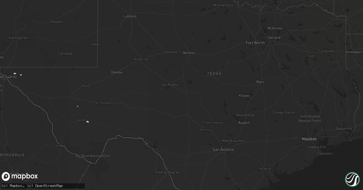
Hail Map in Texas on July 25, 2015
Get this storm
July 25 map
$229
one time, instant access
Download today. No call, no setup
Keep the $229
Bought the map and want the full workflow? Apply the entire $229 to a subscription within 7 days. None of it is wasted.
Every map, not just this one
This buys you this map. Subscription and you get every map we run, in the markets you choose from a few cities to whole states to nationwide. Plus real-time alerts the moment a storm fires.
Contact data
Name, contact info, occupancy, even credit band for addresses in the footprint. You go from where it hit to who to call.
Become the source they trust
Unlimited branding weather history reports on demand. You already have the documented answer ready for the property owner, and you are the one who showed up with it.
Property data and RoofTrace estimates
Pull up any address you have got, its value and the exact code rules for that jurisdiction, straight from One Click Code. Then RoofTrace estimates the squares, pitch, and roof value, priced the way you price.
Storm reports in Texas
Texas
| Date | Description |
|---|---|
| 07/24/20158:00 PM CDT | Estimated between 60 and 70 mph wind gust 4 miles east northeast of dalhart |
| 07/24/20158:00 PM CDT | A local report indicates 1.25 inch wind near 4 ENE DALHART |
| 07/24/20157:53 PM CDT | Hail up to the size of half dollars reported 4 miles east-northeast of dalhart. |
| 07/24/20157:53 PM CDT | Hail up to the size of half dollars reported 4 miles east of dalhart. |
All States Impacted by Hail Map on July 25, 2015
Cities Impacted by Hail Map on July 25, 2015
- Hill City, KS
- Carpenter, SD
- Willow Lake, SD
- Momence, IL
- Fort Hancock, TX
- Horton, KS
- Hiawatha, KS
- Dodge City, KS
- Selby, SD
- Eureka, SD
- Leola, SD
- Long Lake, SD
- Belleville, KS
- Courtland, KS
- Scandia, KS
- Ashley, ND
- Jamesport, MO
- Gilman City, MO
- Armour, SD
- Lake Andes, SD
- Mound City, MO
- Benkelman, NE
- Wahoo, NE
- Delmont, SD
- Macksville, KS
- Rapid City, SD
- Hermosa, SD
- Philip, SD
- Kadoka, SD
- Midland, SD
- Okaton, SD
- Belvidere, SD
- Roxie, MS
- Natchez, MS
- Fayette, MS
- Wauneta, NE
- Palisade, NE
- Miller, SD
- Garfield, KS
- Larned, KS
- Ipswich, SD
- Elmwood, NE
- Murdock, NE
- Alvo, NE
- Doland, SD
- Kimball, SD
- Clark, SD
- Saint Lawrence, SD
- Ree Heights, SD
- Beatrice, NE
- Blue Springs, NE
- Sagle, ID
- Pine Ridge, SD
- Kyle, SD
- Bryant, SD
- White Lake, SD
- Platte, SD
- Dallas, SD
- Colome, SD
- Pukwana, SD
- Winner, SD
- Chamberlain, SD
- Gregory, SD
- Burke, SD
- Corsica, SD
- Hamill, SD
- New Holland, SD
- Harrison, SD
- Geddes, SD
- Keystone, SD
- Campo, CO
- Holly, CO
- Prairie City, IA
- Memphis, MO
- Cowgill, MO
- Springfield, SD
- Unadilla, NE
- Palmyra, NE
- Odell, NE
- Marysville, KS
- Hanover, KS
- Bremen, KS
- Wymore, NE
- Mankato, KS
- Jewell, KS
- Washburn, ND
- Underwood, ND
- Ashland, NE
- Ceresco, NE
- Ithaca, NE
- Mound City, SD
- Herreid, SD
- Iroquois, SD
- Seneca, KS
- Centralia, KS
- Braithwaite, LA
- Belle Chasse, LA
- Ford, KS
- Mellette, SD
- Vermillion, KS
- Frankfort, KS
- Orient, SD
- McCracken, KS
- Brownell, KS
- Nekoma, KS
- Burdett, KS
- Rozel, KS
- Bazine, KS
- Alexander, KS
- Ness City, KS
- Belpre, KS
- La Crosse, KS
- Rush Center, KS
- Hanston, KS
- Virginia, NE
- Burchard, NE
- Liberty, NE
- Bison, KS
- Chapman, KS
- Abilene, KS
- Dante, SD
- Avon, SD
- Ensign, KS
- Sumner, IA
- Beloit, KS
- Grenville, NM
- Cresbard, SD
- Hinton, IA
- Kinsley, KS
- Offerle, KS
- Gettysburg, SD
- Lake Preston, SD
- De Smet, SD
- Enders, NE
- Utica, KS
- Presho, SD
- Northville, SD
- Tolstoy, SD
- Onaka, SD
- Ellis, KS
- Montezuma, KS
- Garden City, KS
- Jetmore, KS
- Pattonsburg, MO
- Bethany, MO
- McFall, MO
- Junction City, KS
- Lawton, IA
- Kingsley, IA
- Moville, IA
- Auburn, NE
- Winnsboro, LA
- Fort Necessity, LA
- Kentland, IN
- Liberty, MS
- Ida Grove, IA
- Novinger, MO
- Porcupine, SD
- Fillmore, MO
- Bolckow, MO
- Monroe, LA
- Collinston, LA
- Hitchcock, SD
- Parkston, SD
- Lewis, KS
- Oldham, SD
- Clyde, MO
- Stanberry, MO
- Ramona, SD
- Boonville, MO
- Cornell, IL
- Blackstone, IL
- Kenton, OK
- Sioux City, IA
- Bogue, KS
- Lenora, KS
- White River, SD
- Murdo, SD
- Roscoe, SD
- Pontiac, IL
- Odell, IL
- De Witt, NE
- Glade, KS
- Logan, KS
- Stockton, KS
- El Paso, TX
- Stella, NE
- Baring, MO
- Glen Elder, KS
- Narka, KS
- Ransom, KS
- Gaylord, KS
- Esbon, KS
- Goff, KS
- Corning, KS
- Hoven, SD
- Tonganoxie, KS
- Linwood, KS
- Lenexa, KS
- Olathe, KS
- Bonner Springs, KS
- Lawrence, KS
- De Soto, KS
- Springview, NE
- Highmore, SD
- Lake Providence, LA
- Raymond, SD
- Bronson, IA
- Dalhart, TX
- Wessington Springs, SD
- Collyer, KS
- Akaska, SD
- Greenwood, NE
- Grant Park, IL
- Draper, SD
- Conde, SD
- Nichols, IA
- Milan, MO
- Morton, MS
- Tyndall, SD
- Wolsey, SD
- Battle Creek, IA
- Lennox, SD
- Davis, SD
- Hurley, SD
- Box Elder, SD
- Westwego, LA
- Marrero, LA
- Monroe City, MO
- Clayton, NM
- Slidell, LA
- Anthon, IA
- Holton, KS
- Bloomfield, NE
- Yale, SD
- Turton, SD
- Haddam, KS
- Cuba, KS
- Troy, KS
- Bendena, KS
- Atchison, KS
- Denton, KS
- Lancaster, KS
- Cimarron, KS
- Wagner, SD
- Lake Norden, SD
- Erwin, SD
- Arlington, SD
- Thibodaux, LA
- Faulkton, SD
- Mansfield, SD
- Brentford, SD
- Scott City, KS
- Golden Meadow, LA
- Fairbury, NE
- Sparland, IL
- Shelbina, MO
- Huron, SD
- Axtell, KS
- Winfred, SD
- Rocheport, MO
- Wooldridge, MO
- Carlinville, IL
- Shipman, IL
- Ingalls, KS
- Pelahatchie, MS
- Concordia, KS
- Waverly, NE
- Lincoln, NE
- Dwight, IL
- Seneca, SD
- Vienna, SD
- Onaga, KS
- Melvin, MI
- Yale, MI
- Topeka, KS
- Baileyville, KS
- Vermillion, SD
- Overland Park, KS
- Cameron, MO
- Estherville, IA
- Graettinger, IA
- Summerfield, KS
- Beattie, KS
- Falls City, NE
- Sheldon, IL
- Donovan, IL
- Brook, IN
- Morocco, IN
- Merrill, IA
- King City, MO
- Darlington, MO
- Conception Junction, MO
- Conception, MO
- Ravenwood, MO
- Sumrall, MS
- Bowdle, SD
- Wakeeney, KS
- Fort Davis, TX
- Tripoli, IA
- Harrisonburg, LA
- Jonesville, LA
- Sicily Island, LA
- Marathon, TX
- Hemingford, NE
- Lacombe, LA
- Pierceville, KS
- Massena, IA
- Alpha, MN
- Coden, AL
- New Hampton, MO
- Niobrara, NE
- Sutton, NE
- Yeso, NM
- Ferriday, LA
- Coleharbor, ND
- Palmyra, MO
- Philadelphia, MO
- Circleville, KS
- Minneola, KS
- Spearville, KS
- Mayetta, KS
- Hoyt, KS
- Hayti, SD
- Hazel, SD
- Rosendale, MO
- Savannah, MO
- New Franklin, MO
- Blackwater, MO
- Pilot Grove, MO
- Franklin, MO
- Waverly, IA
- Collins, MS
- Stickney, SD
- Monterey, LA
- Ewing, MO
- Emden, MO
- Bethel, MO
- Madison, SD
- Denham Springs, LA
- Walker, LA
- Rushville, MO
- Robinson, KS
- Yankton, SD
- Graham, MO
- Skidmore, MO
- Maitland, MO
- Lena, MS
- Barnard, MO
- Port Saint Joe, FL
- Eagle Butte, SD
- Galliano, LA
- Long Valley, SD
- Vivian, SD
- Barnard, KS
- Sylvan Grove, KS
- Hunter, KS
- Bismarck, AR
- Malvern, AR
- Donaldson, AR
- Kirksville, MO
- Gruver, TX
- Bucklin, KS
- Cavour, SD
- Craig, MO
- Marksville, LA
- Irene, SD
- Menno, SD
- Buras, LA
- Manter, KS
- Beresford, SD
- Carrollton, MO
- Humphreys, MO
- Jamestown, KS
- Howard, SD
- Downing, MO
- Hosmer, SD
- Eudora, AR
- Emington, IL
- Fairview, KS
- Eagle, NE
- Webber, KS
- Louise, MS
- Henry, SD
- White Cloud, KS
- Yazoo City, MS
- Marlette, MI
- Brown City, MI
- Hartsburg, MO
- Weed, NM
- Castlewood, SD
- Fayette, MO
- Caputa, SD
- Scenic, SD
- Eudora, KS


