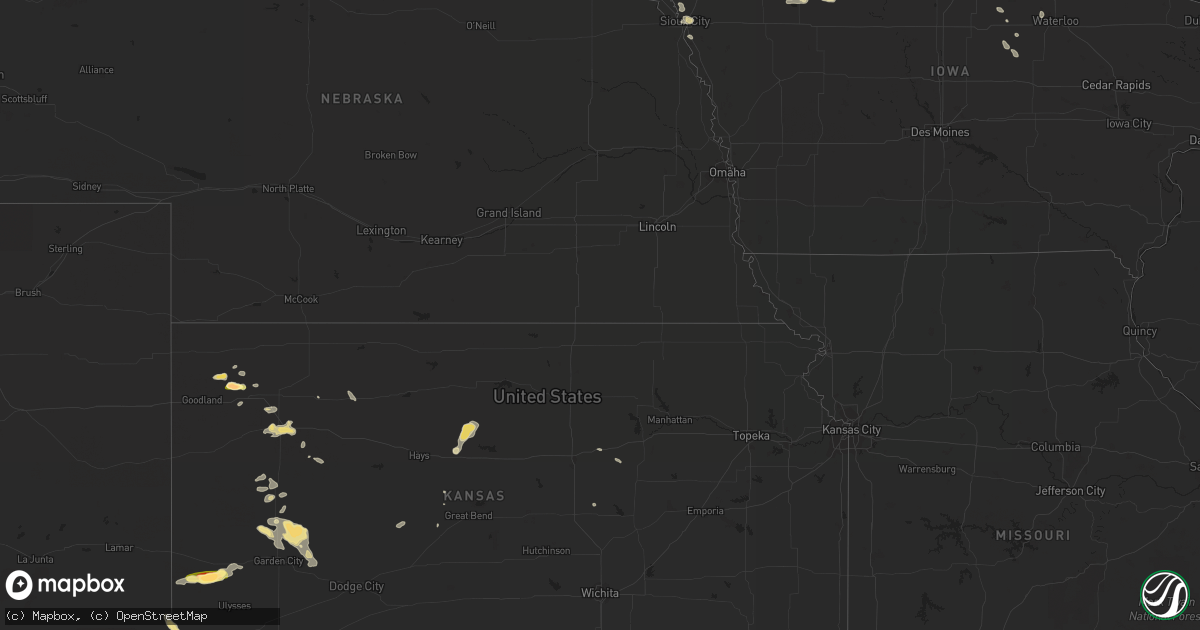
Hail Map in Kansas on July 25, 2013
Get this storm
July 25 map
$229
one time, instant access
Download today. No call, no setup
Keep the $229
Bought the map and want the full workflow? Apply the entire $229 to a subscription within 7 days. None of it is wasted.
Every map, not just this one
This buys you this map. Subscription and you get every map we run, in the markets you choose from a few cities to whole states to nationwide. Plus real-time alerts the moment a storm fires.
Contact data
Name, contact info, occupancy, even credit band for addresses in the footprint. You go from where it hit to who to call.
Become the source they trust
Unlimited branding weather history reports on demand. You already have the documented answer ready for the property owner, and you are the one who showed up with it.
Property data and RoofTrace estimates
Pull up any address you have got, its value and the exact code rules for that jurisdiction, straight from One Click Code. Then RoofTrace estimates the squares, pitch, and roof value, priced the way you price.
Storm reports in Kansas
Kansas
| Date | Description |
|---|---|
| 07/25/20134:28 PM CDT | A local report indicates 1.75 inch wind near 6 SSW KENDALL |
| 07/25/20134:17 PM CDT | Numerous power poles were downed. Roofs were blown off 2 hay buildings. |
| 07/25/20134:08 PM CDT | Mostly quarter size hail with at least one stone that was 2 1/2 inches long and 1 inch wide. |
| 07/25/20134:05 PM CDT | Landspout tornado |
| 07/25/20134:05 PM CDT | Landspout tornado |
| 07/25/20133:39 PM CDT | A local report indicates 60 MPH wind near 5 S ABILENE |
| 07/25/20133:38 PM CDT | A local report indicates 58 MPH wind near ABILENE |
| 07/24/20137:55 PM CDT | A local report indicates 63 MPH wind near 5 N GARDEN CITY |
All States Impacted by Hail Map on July 25, 2013
Cities Impacted by Hail Map on July 25, 2013
- Elysian, MN
- Kilkenny, MN
- Waterville, MN
- Ewen, MI
- Greenville, SC
- Mayo, SC
- Cowpens, SC
- Chesnee, SC
- Pierz, MN
- Congress, AZ
- Mayer, AZ
- Lake Mills, IA
- Northwood, IA
- Seligman, AZ
- Snowflake, AZ
- Doyle, CA
- Bighorn, MT
- Oakley, KS
- Greene, IA
- Bristow, IA
- Lakefield, MN
- Grinnell, KS
- Albuquerque, NM
- Colby, KS
- Edson, KS
- Brewster, KS
- Lake Lure, NC
- Rutherfordton, NC
- Holcomb, KS
- Garden City, KS
- Pavillion, WY
- Rockwell, IA
- Quemado, NM
- Ribera, NM
- Flagstaff, AZ
- Crofton, NE
- Cache, OK
- Guymon, OK
- Sheffield, IA
- Swaledale, IA
- Thornton, IA
- Tucson, AZ
- Upton, WY
- Goodell, IA
- Kanawha, IA
- Onalaska, WI
- Holmen, WI
- West Salem, WI
- Trinidad, CO
- Raton, NM
- Boncarbo, CO
- Le Mars, IA
- Merrill, IA
- Kensett, IA
- Otter, MT
- Niobrara, NE
- Manter, KS
- La Crosse, WI
- Bangor, WI
- La Crescent, MN
- Reno, NV
- Le Roy, MN
- Gruver, TX
- Mountain View, OK
- Williams, AZ
- Sierraville, CA
- Loyalton, CA
- Weatherford, OK
- Walters, OK
- Temple, OK
- Cresco, IA
- Harmony, MN
- Rolla, KS
- Anton Chico, NM
- Mill Spring, NC
- Brewster, MN
- Gaffney, SC
- Hydro, OK
- Coleridge, NE
- Waldo, KS
- Luray, KS
- Russell, KS
- Little Falls, MN
- Storm Lake, IA
- Kingman, AZ
- Snyder, TX
- Syracuse, KS
- Kendall, KS
- Lakin, KS
- Osceola, WI
- Clear Lake, WI
- Taylors Falls, MN
- Center City, MN
- Dresser, WI
- Saint Croix Falls, WI
- Amery, WI
- Deer Park, WI
- Shafer, MN
- Orr, MN
- Anson, TX
- Ryegate, MT
- Reed Point, MT
- Shawmut, MT
- Melville, MT
- Rapelje, MT
- Big Timber, MT
- Box Elder, MT
- Lawton, OK
- Harlowton, MT
- Two Dot, MT
- Cedar Falls, IA
- Prescott, AZ
- Pocahontas, IA
- Fonda, IA
- Algona, IA
- Owatonna, MN
- Ganado, AZ
- Houston, MN
- Monument, KS
- Hoxie, KS
- Mooresboro, NC
- Leland, IA
- Paulden, AZ
- Superior, AZ
- Florence, AZ
- Preston, MN
- Big Falls, MN
- Littlefork, MN
- Cook, MN
- Effie, MN
- Floodwood, MN
- Wright, MN
- Kirkland, AZ
- Walsh, CO
- Scott City, KS
- Ash Fork, AZ
- Mooreland, OK
- Rockland, WI
- Walsenburg, CO
- Rye, CO
- Forsyth, MT
- Lame Deer, MT
- Elkhart, KS
- Corrales, NM
- Bernalillo, NM
- Hartington, NE
- Laurel, NE
- Marion, NC
- Albert City, IA
- Madison Lake, MN
- Solano, NM
- Conchas Dam, NM
- Chester, IA
- Lime Springs, IA
- Ostrander, MN
- Spring Valley, MN
- Rudyard, MT
- Faxon, OK
- Rapid City, SD
- Piedmont, SD
- Lenoir, NC
- Richfield, KS
- Britt, IA
- Geronimo, OK
- Cordell, OK
- Lindstrom, MN
- Mankato, MN
- Tilden, NE
- Cromwell, MN
- Augusta, WI
- Tryon, NC
- Columbus, NC
- Saint Johns, AZ
- Leonard, MN
- Lyman, SC
- Greer, SC
- Union Mills, NC
- Simpsonville, SC
- Mauldin, SC
- Okeene, OK
- De Leon, TX
- Desdemona, TX
- Ranger, TX
- Dublin, TX
- Peterson, IA
- Linn Grove, IA
- Old Fort, NC
- Eagle Lake, MN
- Thomas, OK
- Custer City, OK
- Hurley, WI
- Montreal, WI
- Hobart, OK
- Paradise, KS
- Peach Springs, AZ
- Canyon, MN
- Alborn, MN
- Saginaw, MN
- Levant, KS
- Decorah, IA
- Sebeka, MN
- Menahga, MN
- Ontonagon, MI
- Clear Lake, IA
- Emmons, MN
- Enterprise, KS
- Abilene, KS
- Joice, IA
- Okatie, SC
- Ridgeland, SC
- Carnegie, OK
- Apache, OK
- Saint Michaels, AZ
- Clinton, OK
- Rincon, GA
- Port Wentworth, GA
- Alexander, IA
- Latimer, IA
- Coulter, IA
- Hampton, IA
- Cohasset, MN
- Parkersburg, IA
- Wellsburg, IA
- Gotebo, OK
- Keyes, OK
- Alamo, GA
- Dougherty, IA
- Mason City, IA
- Travelers Rest, SC
- Taylors, SC
- Conrad, IA
- Beaman, IA
- Grundy Center, IA
- Bricelyn, MN
- Kiester, MN
- Laramie, WY
- Box Elder, SD
- Ellsworth Afb, SD
- Taloga, OK
- Sentinel, OK
- Dill City, OK
- Rocky, OK
- Sioux City, IA
- Westfield, IA
- Hinton, IA
- Thompson, IA
- Meriden, IA
- Dannebrog, NE
- Clarendon, TX
- South Sioux City, NE
- Center, NE
- Alden, MN
- Sharon, OK
- Woodward, OK
- Mutual, OK
- Six Mile, SC
- Meadowlands, MN
- Okabena, MN
- Ingalls, KS
- Boyceville, WI
- Clayton, WI
- Prairie Farm, WI
- Litchfield, MN
- Clarkesville, GA
- Jayton, TX
- McDonald, KS
- Yarnell, AZ
- Marenisco, MI
- Bergland, MI
- Winslow, AZ
- Gile, WI
- Wells, MN
- Grove City, MN
- Cosmos, MN
- Truman, MN
- Curlew, IA
- Binger, OK
- Arapaho, OK
- Lookeba, OK
- Hinton, OK
- Colony, OK
- Corn, OK
- Larrabee, IA
- Aurelia, IA
- Homewood, CA
- Tahoma, CA
- Tahoe City, CA
- Emmetsburg, IA
- Woden, IA
- Garner, IA
- Titonka, IA
- Forest City, IA
- Ventura, IA
- Klemme, IA
- Lone Wolf, OK
- Roosevelt, OK
- Brownsdale, MN
- Austin, MN
- Wakefield, MI
- Sunray, TX
- Stratford, TX
- Sparta, WI
- Los Alamos, NM
- Michigamme, MI
- Winnetoon, NE
- Verdigre, NE
- Fulda, MN
- Ackley, IA
- Aplington, IA
- Austinville, IA
- Wauzeka, WI
- Ridgeland, WI
- Burdett, KS
- Bloomfield, NE
- Belmond, IA
- Dexter, MN
- Lakeview, TX
- Quitaque, TX
- Hillman, MN
- Alcester, SD
- Putnam, OK
- Sparks, NV
- Lanesboro, MN
- Fountain, MN
- Saint Charles, MN
- Lewiston, MN
- Utica, MN
- Piedmont, SC
- Pelzer, SC
- Gladbrook, IA
- Savannah, GA
- Anadarko, OK
- Fort Cobb, OK
- Hackberry, AZ
- Crystal Lake, IA
- Waseca, MN
- Wheeler, WI
- Kasota, MN
- Otis, KS
- Gove, KS
- Larned, KS
- Corwith, IA
- Newell, IA
- Rolfe, IA
- Havelock, IA
- Laurens, IA
- Gilmore City, IA
- Remsen, IA
- Dakota, MN
- Fort Supply, OK
- Buffalo, OK
- Miami, AZ
- Worthington, MN
- Eastman, WI
- Steuben, WI
- Morristown, MN
- Cimarron, KS
- Healy, KS
- Havre, MT
- Verndale, MN
- Stapleton, NE
- North Platte, NE
- Ironwood, MI
- Elk Point, SD
- Akron, IA
- Hardeeville, SC
- Truckee, CA
- Meservey, IA
- Big Sandy, MT
- Sergeant Bluff, IA
- Salix, IA
- Grafton, IA
- Manly, IA
- Benson, AZ
- Hollandale, MN
- Ellendale, MN
- Blooming Prairie, MN
- Hobson, MT
- Morland, KS
- Penokee, KS
- Boiling Springs, SC
- Spartanburg, SC
- Inman, SC
- Alta, IA
- Canton, KS
- Vici, OK
- Mallard, IA
- Allison, IA
- Dumont, IA
- Le Center, MN
- Cleveland, MN
- Hawarden, IA
- Campobello, SC
- Wellford, SC
- Marcus, IA
- Galesville, WI
- Ridgeway, IA
- Solomon, KS
- Colorado City, CO
- Pueblo, CO
- Brookston, MN
- Albert, KS
- Randall, MN
- Cushing, MN
- Ocate, NM
- Canon City, CO
- Duluth, MN
- Aguilar, CO
- Norwalk, WI


