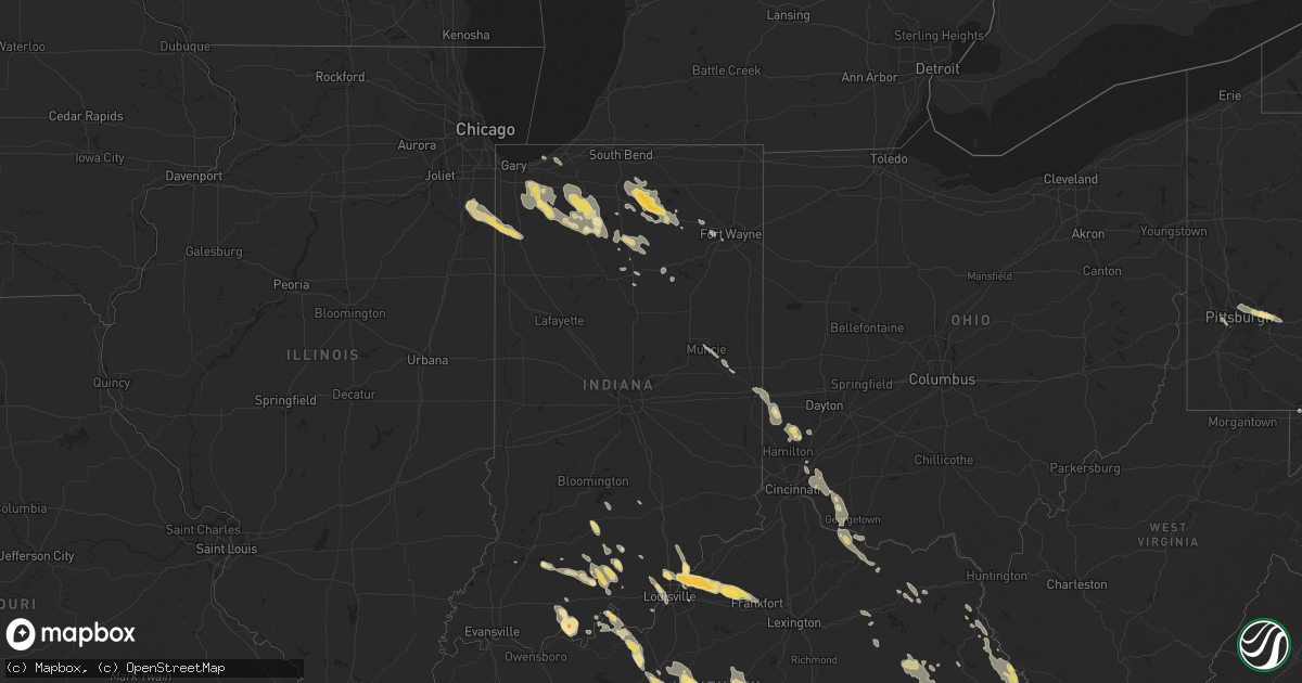
Hail Map in South Carolina on July 24, 2012
Get this storm
July 24 map
$229
one time, instant access
Download today. No call, no setup
Keep the $229
Bought the map and want the full workflow? Apply the entire $229 to a subscription within 7 days. None of it is wasted.
Every map, not just this one
This buys you this map. Subscription and you get every map we run, in the markets you choose from a few cities to whole states to nationwide. Plus real-time alerts the moment a storm fires.
Contact data
Name, contact info, occupancy, even credit band for addresses in the footprint. You go from where it hit to who to call.
Become the source they trust
Unlimited branding weather history reports on demand. You already have the documented answer ready for the property owner, and you are the one who showed up with it.
Property data and RoofTrace estimates
Pull up any address you have got, its value and the exact code rules for that jurisdiction, straight from One Click Code. Then RoofTrace estimates the squares, pitch, and roof value, priced the way you price.
Storm reports in South Carolina
South Carolina
| Date | Description |
|---|---|
| 07/24/20126:28 PM CDT | Tree in roadway near intersection of delta road and whitmire highway. |
| 07/24/20126:18 PM CDT | Tree in roadway near intersection of highway 72 and renno road. |
| 07/24/20126:17 PM CDT | Two trees down in starr. |
| 07/24/20126:00 PM CDT | Tree in roadway near intersection of highway 185 and highway 28. |
| 07/24/20125:58 PM CDT | Large branches down. |
| 07/24/20125:56 PM CDT | Tree in roadway near intersection of highway 252 and shirley store road. |
| 07/24/20125:55 PM CDT | Trees reported to be down around enoree. |
| 07/24/20125:30 PM CDT | Tree in roadway at southport road and cedar springs road. |
| 07/24/20125:28 PM CDT | Two trees down. One tree blocking roadway with powerlines down on woodland street just off pine street. The other was half of a maple tree split on anita drive. |
| 07/24/20125:26 PM CDT | Powerlines down near converse college on blue ridge street and high tension powerline reported down in the hillbrook area. |
| 07/24/20125:25 PM CDT | Trees down around hickory tavern. |
| 07/24/20125:22 PM CDT | Report of large limbs down and power outages in winnsboro. |
| 07/24/20125:18 PM CDT | Highway patrol reported trees down near white oak |
| 07/24/20125:15 PM CDT | Tree down at the intersection of georgia road and baynes creek road. |
| 07/24/20125:07 PM CDT | One very large branch down at a residence and several other limbs of various sizes down in the immediate area. Power was out. |
| 07/24/20122:44 PM CDT | The allendale emergency manager reported several large trees and power lines down near the intersection of highway 125 and millett road. One tree fell on a tanker. |
| 07/23/201210:15 PM CDT | 1 palmetto tree down. Very strong wind lasted 2 to 3 minutes. |
| 07/23/20129:40 PM CDT | Sc highway patrol reports a tree down and in the roadway near the intersection of pocotaligo road and tulifinney road. |
| 07/23/20129:40 PM CDT | A tree was reported down near the intersection of clinic drive and ace basin parkway. |
| 07/23/20129:37 PM CDT | Tree down near the intersection of locust street and shaw drive. Time estimated based on radar. |
| 07/23/20129:25 PM CDT | Tree down along highway 601 near crocketville. Time estimated based on radar. |
| 07/23/20128:59 PM CDT | Powerlines down along highway 176 near the mcalister smith funeral home. Time estimated based on radar. |
| 07/23/20128:55 PM CDT | The public reported 1 tree down along interstate 26 between mile markers 201 and 202. |
| 07/23/20127:57 PM CDT | The berkeley 911 call center relayed a report of a tree down along arrowhead road. |
All States Impacted by Hail Map on July 24, 2012
Cities Impacted by Hail Map on July 24, 2012
- Ty Ty, GA
- Tifton, GA
- Salt Point, NY
- Salem, IN
- Buffalo, SD
- Rhame, ND
- Bowman, ND
- Gillette, WY
- Louisa, KY
- Littlefield, AZ
- South Portland, ME
- Peaks Island, ME
- Long Island, ME
- Cape Elizabeth, ME
- Falmouth, ME
- Portland, ME
- Momence, IL
- Manteno, IL
- Grant Park, IL
- Navarre, FL
- Johnson City, TN
- Grand Rapids, MN
- Anderson, SC
- Wadesboro, NC
- Kinston, NC
- Aberdeen, SD
- Columbia, SD
- Whitsett, NC
- Julian, NC
- New England, ND
- Hemingway, SC
- Westport, SD
- Roscoe, SD
- Leola, SD
- Ipswich, SD
- Chester, VA
- Colonial Heights, VA
- Disputanta, VA
- Prince George, VA
- Fort Lee, VA
- Chesterfield, VA
- Petersburg, VA
- Hopewell, VA
- Lowmansville, KY
- Inez, KY
- Hereford, TX
- Tintah, MN
- Jasper, IN
- Montgomery, IN
- Otwell, IN
- Trenton, OH
- Middletown, OH
- Somerville, OH
- Mellen, WI
- Claremont, SD
- Ekron, KY
- Guston, KY
- Brandenburg, KY
- Sturgis, SD
- Piedmont, SD
- Andrews, SC
- Jamestown, SC
- Lane, SC
- Winthrop, MA
- Roseboro, NC
- Clinton, NC
- Bourbon, IN
- Argos, IN
- Plymouth, IN
- White Owl, SD
- Verona, ND
- Lamoure, ND
- Milford, OH
- Loveland, OH
- Cincinnati, OH
- Batavia, OH
- Terrace Park, OH
- Camp Dennison, OH
- Greenville, NC
- Clinton Corners, NY
- Staatsburg, NY
- Pleasant Valley, NY
- Hyde Park, NY
- Millbrook, NY
- Hawley, MN
- Barnesville, MN
- Yeaddiss, KY
- Hazel Green, KY
- Rowdy, KY
- Bays, KY
- Combs, KY
- Chavies, KY
- Bulan, KY
- Happy, KY
- Hueysville, KY
- Campton, KY
- Rousseau, KY
- Clayhole, KY
- Ary, KY
- Vest, KY
- Vicco, KY
- Bonnyman, KY
- Viper, KY
- Cornettsville, KY
- Mize, KY
- Cannel City, KY
- Lost Creek, KY
- Jeff, KY
- Hazard, KY
- Jackson, KY
- Vancleve, KY
- Salyersville, KY
- La Grange, KY
- Buckner, KY
- Crestwood, KY
- Williamsburg, VA
- Callaway, MN
- Regent, ND
- Mott, ND
- Liberty, NC
- Pierceton, IN
- Winona Lake, IN
- Warsaw, IN
- Kindred, ND
- Davenport, ND
- Accident, MD
- Swanton, MD
- Grantsville, MD
- Norwell, MA
- Hull, MA
- Scituate, MA
- South Boston, MA
- Marshfield, MA
- Cohasset, MA
- Hingham, MA
- Sheldon, ND
- Glendive, MT
- Walterboro, SC
- Fairhaven, MA
- Rochester, IN
- Akron, IN
- Hardinsburg, IN
- Marengo, IN
- Paoli, IN
- Milltown, IN
- Pelican Rapids, MN
- Fort Pierre, SD
- Eaton, OH
- Pembroke, MA
- Hanover, MA
- Lilesville, NC
- Rockingham, NC
- Ellerbe, NC
- Blakely, GA
- Troy, IN
- Tell City, IN
- Germantown, KY
- Augusta, KY
- Dover, KY
- Milton, NH
- Lebanon, ME
- Milesville, SD
- Walcott, ND
- Kadoka, SD
- Delmont, NJ
- Port Norris, NJ
- Leesburg, NJ
- Cape May Court House, NJ
- Woodbine, NJ
- Heislerville, NJ
- Millville, NJ
- Jackson Springs, NC
- Eagle Springs, NC
- West End, NC
- Biscoe, NC
- Candor, NC
- Carthage, NC
- Jonesborough, TN
- Limestone, TN
- Chuckey, TN
- Sumter, SC
- Wedgefield, SC
- Belfry, KY
- Williamson, WV
- South Williamson, KY
- Wooton, KY
- Gordon, KY
- Delphia, KY
- Slemp, KY
- Bloomfield, MT
- Lindsay, MT
- West Brookfield, MA
- Gilbertville, MA
- New Braintree, MA
- Ware, MA
- Winnsboro, SC
- Wendell, NC
- Clayton, NC
- Kenly, NC
- Middlesex, NC
- Selma, NC
- Zebulon, NC
- Lisbon, ND
- Camden, OH
- Athol, MA
- Loogootee, IN
- Warren, MA
- Brookfield, MA
- Wibaux, MT
- Dubois, IN
- French Lick, IN
- English, IN
- Eckerty, IN
- Taswell, IN
- Menahga, MN
- Sebeka, MN
- Verbank, NY
- Windsor, NC
- Wahpeton, ND
- Sellersburg, IN
- Mitchell, IN
- Bedford, IN
- Lambert, MT
- Selma, IN
- Muncie, IN
- Cuthbert, GA
- Eolia, KY
- Pound, VA
- Mount Gilead, NC
- Fair Oaks, IN
- Lake Village, IN
- Morocco, IN
- Snow Camp, NC
- Kouts, IN
- Wheatfield, IN
- San Pierre, IN
- Goffstown, NH
- Horace, ND
- Olive Hill, KY
- Vanceburg, KY
- Cassatt, SC
- Fayetteville, NC
- Stedman, NC
- Fitzgerald, GA
- Abbeville, GA
- Enderlin, ND
- Howes, SD
- East Point, KY
- Peru, IN
- Horse Cave, KY
- Munfordville, KY
- Charlestown, IN
- Memphis, IN
- Gettysburg, SD
- Vine Grove, KY
- Dover Plains, NY
- Lagrangeville, NY
- Middleboro, MA
- Bridgewater, MA
- Leavenworth, IN
- Nappanee, IN
- Etna Green, IN
- Leesburg, IN
- Bremen, IN
- Alna, ME
- Dresden, ME
- Wadena, MN
- Christine, ND
- Moorhead, MN
- Petersham, MA
- Atwood, IN
- Larwill, IN
- Claypool, IN
- Milford, IN
- Mentone, IN
- Somerset, KY
- Eubank, KY
- Crab Orchard, KY
- Ripley, OH
- Aberdeen, OH
- Maysville, KY
- Litchville, ND
- Grifton, NC
- Erwin, TN
- Monroeville, PA
- Pittsburgh, PA
- Murrysville, PA
- North Judson, IN
- Knox, IN
- Fullerton, ND
- Bagdad, KY
- Pleasureville, KY
- Eminence, KY
- Shelbyville, KY
- Evanston, IN
- Bethune, SC
- Wolverton, MN
- Unicoi, TN
- Hampton, TN
- New Hope, KY
- Mount Sherman, KY
- Hodgenville, KY
- Raywick, KY
- Magnolia, KY
- Buffalo, KY
- Campbellsville, KY
- New Haven, KY
- Galeton, CO
- Bonneau, SC
- Saint Stephen, SC
- Winamac, IN
- Louisville, KY
- Hawesville, KY
- Ferdinand, IN
- Saint Meinrad, IN
- Lynn, MA
- Peabody, MA
- Salem, MA
- McAndrews, KY
- Canada, KY
- Huddy, KY
- Stone, KY
- Pinsonfork, KY
- Hardy, KY
- Forest Hills, KY
- Sidney, KY
- New Albany, IN
- Floyds Knobs, IN
- Pittsboro, NC
- Colfax, ND
- Sedona, AZ
- Midland, SD
- Okaton, SD
- Belvidere, SD
- Murdo, SD
- East Sandwich, MA
- Sandwich, MA
- Leon, WV
- Bennington, VT
- Spring Grove, VA
- Charles City, VA
- Elm City, NC
- Macclesfield, NC
- Gray Court, SC
- Greensboro, NC
- Losantville, IN
- Modoc, IN
- Parker City, IN
- Campbellsburg, IN
- Wyndmere, ND
- Duffield, VA
- Dryden, VA
- Big Stone Gap, VA
- Gardiner, ME
- Nemo, SD
- Deadwood, SD
- Franklinville, NJ
- Monroeville, NJ
- Culver, IN
- Monterey, IN
- Lidgerwood, ND
- Morehead, KY
- Rome, IN
- Autryville, NC
- Siler City, NC
- Chapel Hill, NC
- Graham, NC
- Wilson, NC
- Belle Fourche, SD
- Raleigh, NC
- Knightdale, NC
- Mcville, ND
- Hookerton, NC
- Logansport, IN
- Fairview, MT
- Park Falls, WI
- Peotone, IL
- Lowell, IN
- Upton, KY
- Sonora, KY
- Glendale, KY
- Bonnieville, KY
- Partridge, KY
- Whitesburg, KY
- Staley, NC
- Mebane, NC
- Columbia City, IN
- Merry Hill, NC
- Battletown, KY
- Stantonsburg, NC
- Comstock, MN
- Sabin, MN
- Kershaw, SC
- Jefferson, SC
- Java, SD
- Bowdle, SD
- Dunn, NC
- Union, SC
- Enoree, SC
- Fort Ransom, ND
- Valparaiso, IN
- Kathryn, ND
- Nome, ND
- Harbinger, NC
- Ekalaka, MT
- Lewiston Woodville, NC
- Hamilton, NC
- Goldsboro, NC
- Mount Olive, NC
- Four Oaks, NC
- Caryville, FL
- Vernon, FL
- Elizabethtown, KY
- Rineyville, KY
- Cecilia, KY
- Cape Neddick, ME
- Ponce De Leon, FL
- Bunnlevel, NC
- Linden, NC
- Spring Lake, NC
- Swampscott, MA
- Marblehead, MA
- Lynnfield, MA
- Amherst, SD
- Nahant, MA
- Parksville, KY
- Lebanon, KY
- Springfield, KY
- Perryville, KY
- Hustonville, KY
- Bradfordsville, KY
- Gravel Switch, KY
- Laporte, MN
- Export, PA
- Verona, PA
- Washington, NC
- Donalsonville, GA
- Spearfish, SD
- Depauw, IN
- Dagmar, MT
- Black Hawk, SD
- Warfield, KY
- Lovely, KY
- New Effington, SD
- Edenton, NC
- Colerain, NC
- Ludlow, SD
- Frenchburg, KY
- Grimesland, NC
- Hamersville, OH
- Bethel, OH
- Selfridge, ND
- Derby, IN
- Cannelton, IN
- Hardwick, MA
- North Brookfield, MA
- Campbell, MN
- Ocilla, GA
- Acton, ME
- Edgemont, SD
- Philip, SD
- Felicity, OH
- Georgetown, OH
- Mount Orab, OH
- Williamsburg, OH
- Ermine, KY
- Newton Grove, NC
- Princeton, NC
- Dudley, NC
- Seven Springs, NC
- Marion, ND
- Leonard, ND
- Rensselaer, IN
- Beecher, IL
- Schneider, IN
- Lansing, NC
- Kingsport, TN
- Blountville, TN
- Roan Mountain, TN
- Cherry Creek, SD
- Elmer, NJ
- Leary, GA
- Felda, FL
- Labelle, FL
- Hayward, WI
- Fort Blackmore, VA
- Dungannon, VA
- Goshen, KY
- Jeffersonville, IN
- Prospect, KY
- Partlow, VA
- Bumpass, VA
- Somerville, MA
- Medford, MA
- Arlington, MA
- Starr, SC
- Richmond, IN
- New Paris, OH
- Pomaria, SC
- Prosperity, SC
- Stamford, VT
- Wenham, MA
- Danvers, MA
- Topsfield, MA
- Middleton, MA
- Boxford, MA
- Heltonville, IN
- Norman, IN
- Lucama, NC
- Essex, MA
- Rhodelia, KY
- Elizabethtown, NC
- Hermosa, SD
- West Fargo, ND
- Fargo, ND
- Union, NH
- New Durham, NH
- Franklinville, NC
- Ramseur, NC
- Wytopitlock, ME
- Kennebunkport, ME
- Wabash, IN
- Cass Lake, MN
- Richey, MT
- Pleasant Garden, NC
- Climax, NC
- Burlington, NC
- Randleman, NC
- Apex, NC
- New Hill, NC
- La Crosse, IN
- Hanna, IN
- Hamlet, IN
- Kewanna, IN
- Wallingford, KY
- Flemingsburg, KY
- Santa Claus, IN
- Lamar, IN
- Sundance, WY
- Summersville, KY
- Scottsburg, IN
- Lexington, IN
- Stirum, ND
- Gwinner, ND
- Nobleboro, ME
- Wiscasset, ME
- Damariscotta, ME
- Newcastle, ME
- Jefferson, ME
- Immokalee, FL
- Laurens, SC
- Felton, MN
- Erhard, MN
- Rothsay, MN
- Damascus, GA
- Orleans, IN
- Pope Army Airfield, NC
- Kingston, MA
- Duxbury, MA
- Richmond, ME
- Toano, VA
- Keyser, WV
- Rosholt, SD
- Sisseton, SD
- Browns Valley, MN
- Macy, IN
- Chestnut Hill, MA
- Newton Center, MA
- Park Rapids, MN
- Brule, WI
- Fuquay Varina, NC
- Holly Springs, NC
- Newcastle, WY
- Carnegie, PA
- Bridgeville, PA
- Oakdale, PA
- Presto, PA
- Wheaton, MN
- Piney Flats, TN
- Payneville, KY
- Bonifay, FL
- Greensburg, KY
- Iron River, WI
- Clinton, SC
- Chula, GA
- Dale, IN
- Lewisport, KY
- Bennett, NC
- Poulan, GA
- Sylvester, GA
- Sumner, GA
- Iva, SC
- Allison Park, PA
- Greensburg, PA
- Delmont, PA
- Glenshaw, PA
- Oakes, ND
- Mousie, KY
- Olympia, KY
- Means, KY
- Owingsville, KY
- Monroe City, IN
- Suffolk, VA
- Ashburn, GA
- Mason, WI
- Peach Springs, AZ
- Butler, TN
- Hardyville, KY
- Southern Pines, NC
- Troy, NC
- Pinehurst, NC
- Vass, NC
- Eden, SD
- Kennebunk, ME
- Telford, TN
- Chipley, FL
- Houghton, SD
- Gorham, ME
- Williamston, NC
- Boston, KY
- Chesapeake, VA
- Portsmouth, VA
- Morven, NC
- Salemburg, NC
- Wade, NC
- Edison, GA
- Cuttyhunk, MA
- Emerson, KY
- Lugoff, SC
- Camden, SC
- Kinards, SC
- Revere, MA
- Hindman, KY
- Littcarr, KY
- Seymour, IN
- Walstonburg, NC
- Round O, SC
- Ipswich, MA
- Newbury, MA
- Rowley, MA
- Cohasset, MN
- Nashua, MN
- Manchester, MA
- Selby, SD
- Germantown, OH
- Hamilton, OH
- Stanford, KY
- Boone Grove, IN
- Ora, IN
- Grovertown, IN
- Union Mills, IN
- Wanatah, IN
- Crown Point, IN
- Hebron, IN
- Nabb, IN
- Smithfield, KY
- Borden, IN
- Marysville, IN
- Frankfort, KY
- Otisco, IN
- Simpsonville, KY
- Jenkinsville, SC
- Fredericksburg, IN
- Smithfield, NC
- Appalachia, VA
- Daphne, AL
- Claire City, SD
- Hankinson, ND
- Rebecca, GA
- Elizabeth, IN
- Lake Park, MN
- Webster, KY
- Mauckport, IN
- Sycamore, GA
- Rapid City, SD
- Newberry, SC
- Whitmire, SC
- Fort Wayne, IN
- West Bridgewater, MA
- Audubon, MN
- Fall Branch, TN
- Cary, NC
- Moncure, NC
- Beardsley, MN
- Westbrook, ME
- Scarborough, ME
- Beulah, WY
- Michigan City, IN
- La Porte, IN
- McBee, SC
- Lyons, GA
- Detroit Lakes, MN
- Rochert, MN
- Elizabethton, TN
- Watauga, TN
- Mullica Hill, NJ
- Newfield, NJ
- Clayton, NJ
- Malaga, NJ
- Glassboro, NJ
- New Bedford, MA
- North Dartmouth, MA
- Mattapoisett, MA
- Orange, VA
- Glyndon, MN
- Tarboro, NC
- Woburn, MA
- Dorchester, MA
- Wilmington, MA
- Wakefield, MA
- Saugus, MA
- Stoneham, MA
- Reading, MA
- East Boston, MA
- Boston, MA
- Melrose, MA
- Cambridge, MA
- Malden, MA
- Chelsea, MA
- Charlestown, MA
- Everett, MA
- Veblen, SD
- Whitetop, VA
- Moyock, NC
- Minong, WI
- South Hamilton, MA
- Powells Point, NC
- Point Harbor, NC
- Pinetops, NC
- Wall, SD
- Barre, MA
- Addison, PA
- Friendsville, MD
- Coleman, GA
- Snow Hill, NC
- Ayden, NC
- Kimper, KY
- Debord, KY
- Big Rock, VA
- Grundy, VA
- Steele, KY
- Varney, KY
- Pilgrim, KY
- Tomahawk, KY
- Phelps, KY
- Hurley, VA
- Ransom, KY
- Phyllis, KY
- Plymouth, MA
- Loxahatchee, FL
- Bard, NM
- Fort Stockton, TX
- Adams, KY
- Oak City, NC
- Mcleod, ND
- Mayslick, KY
- Brooksville, KY
- Garner, NC
- Culbertson, MT
- Vineland, NJ
- Fountain Inn, SC
- Denver, IN
- White Oak, NC
- Roann, IN
- Silver Lake, IN
- Quincy, MA
- Milton, MA
- Braintree, MA
- Troutdale, VA
- Cannelburg, IN
- Celestine, IN
- Birdseye, IN
- Pierre, SD
- Providence Forge, VA
- North Berwick, ME
- Hosmer, SD
- New Leipzig, ND
- Franklin, OH
- Cushing, ME
- Cascade, MD
- Smithsburg, MD
- Hecla, SD
- West Baden Springs, IN
- Frederick, SD
- Evans, WV
- Given, WV
- Farmville, NC
- Fort Bragg, NC
- Oakham, MA
- Honea Path, SC
- Ware Shoals, SC
- Bremen, ME
- South Whitley, IN
- Williams, AZ
- Bristol, TN
- Waynesburg, KY
- Cameron, NC
- Godwin, NC
- Seagrove, NC
- White River, SD
- Gate City, VA
- Chesterton, IN
- Jacksonville, GA
- Milan, GA
- Rhine, GA
- Irvington, AL
- Mason, OH
- West Chester, OH
- Swan River, MN
- Poquoson, VA
- Union Star, KY
- Georgetown, SC
- Fountain, NC
- Backus, MN
- Hobgood, NC
- Sims, NC
- Mantador, ND
- Mapleton, ND
- Greeneville, TN
- Afton, TN


