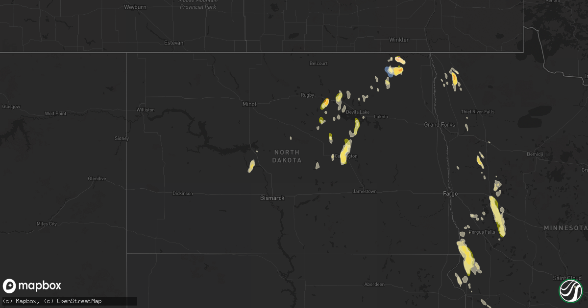
Hail Map in North Dakota on July 22, 2024
Get this storm
July 22 map
$229
one time, instant access
Download today. No call, no setup
Keep the $229
Bought the map and want the full workflow? Apply the entire $229 to a subscription within 7 days. None of it is wasted.
Every map, not just this one
This buys you this map. Subscription and you get every map we run, in the markets you choose from a few cities to whole states to nationwide. Plus real-time alerts the moment a storm fires.
Contact data
Name, contact info, occupancy, even credit band for addresses in the footprint. You go from where it hit to who to call.
Become the source they trust
Unlimited branding weather history reports on demand. You already have the documented answer ready for the property owner, and you are the one who showed up with it.
Property data and RoofTrace estimates
Pull up any address you have got, its value and the exact code rules for that jurisdiction, straight from One Click Code. Then RoofTrace estimates the squares, pitch, and roof value, priced the way you price.
Storm reports in North Dakota
North Dakota
| Date | Description |
|---|---|
| 07/22/20246:50 PM CDT | Time estimated from radar. |
| 07/22/20246:43 PM CDT | Time estimated from radar. |
| 07/22/20246:30 PM CDT | Time estimated from caller and radar. |
| 07/22/20244:36 PM CDT | A local report indicates 1.75 inch wind near Walhalla |
| 07/22/20244:30 PM CDT | Estimated from picture. |
| 07/22/20244:11 PM CDT | Corrects previous tstm wnd gst report from 10 e langdon. |
| 07/22/20244:10 PM CDT | A local report indicates 71 MPH wind near 10 E Langdon |
| 07/22/20243:40 PM CDT | Time estimated. |
| 07/22/20243:16 PM CDT | Still hailing at the time of the report. |
| 07/21/20248:20 PM CDT | Briefly gusted up to 60 mph as the storm came in... Along with pea-sized hail and lots of rain. |
| 07/21/20247:40 PM CDT | Many branches up to 12 inches in diameter down. |
| 07/21/20247:40 PM CDT | Time estimated from radar. |
| 07/21/20247:10 PM CDT | Half dollar to ping pong ball sized hail. Covered about 15 to 20 percent of the ground. No wind. |
All States Impacted by Hail Map on July 22, 2024
Cities Impacted by Hail Map on July 22, 2024
- Deming, NM
- Ulster, PA
- Milan, PA
- Towanda, PA
- Rome, PA
- Sunbury, PA
- Maine, NY
- Whitney Point, NY
- Lisle, NY
- Clinton, NC
- Rose Hill, NC
- Garland, NC
- Selinsgrove, PA
- Northumberland, PA
- Shamokin Dam, PA
- Phillips, WI
- Brewton, AL
- Castleberry, AL
- Milaca, MN
- Park, KS
- Princeton, MN
- Evergreen, AL
- Superior, WI
- Foxboro, WI
- De Berry, TX
- Ganado, AZ
- Raleigh, NC
- Starke, FL
- Marshall, NC
- Leicester, NC
- Alderson, WV
- Wolfcreek, WV
- Cavalier, ND
- Wake Forest, NC
- Walhalla, ND
- Langdon, ND
- Webster, WI
- Danbury, WI
- Goodwell, OK
- Karlstad, MN
- Halma, MN
- Mountain, ND
- Venus, FL
- Milton, ND
- Osnabrock, ND
- Edinburg, ND
- Hensel, ND
- Central, UT
- Stephen, MN
- Clare, IL
- Colorado City, AZ
- Florence, SC
- Ribera, NM
- Lake Bronson, MN
- Hallock, MN
- Fairdale, ND
- Savannah, GA
- Beckwourth, CA
- Greenbrier, TN
- Springfield, TN
- Elk River, MN
- White House, TN
- Texhoma, OK
- Bruce, WI
- Kennedy, MN
- Jetmore, KS
- Spearville, KS
- Wright, KS
- Offerle, KS
- Kinsley, KS
- Ford, KS
- Bucklin, KS
- Haines City, FL
- Winter Haven, FL
- Clermont, FL
- Saint Paul, MN
- Lake Elmo, MN
- Stillwater, MN
- Hudson, WI
- Lakeland, MN
- Bayport, MN
- Hastings, MN
- River Falls, WI
- South Saint Paul, MN
- Cottage Grove, MN
- Inver Grove Heights, MN
- Newport, MN
- Afton, MN
- Saint Paul Park, MN
- Cando, ND
- Leeds, ND
- Churchs Ferry, ND
- Alsen, ND
- Riverview, FL
- Johnson, KS
- Roberts, WI
- Prescott, WI
- Beldenville, WI
- Ellsworth, WI
- Hager City, WI
- Seligman, AZ
- Lake Benton, MN
- Circle Pines, MN
- Hugo, MN
- Ingalls, KS
- Cimarron, KS
- Leesburg, FL
- Copeland, KS
- Anoka, MN
- Minneapolis, MN
- Valrico, FL
- Lithia, FL
- Brandon, FL
- Saint Michael, ND
- Sheyenne, ND
- Warwick, ND
- East Aurora, NY
- Burdett, KS
- Sumterville, FL
- Clearwater, MN
- Monticello, MN
- Clear Lake, MN
- Ness City, KS
- Peach Springs, AZ
- Champlin, MN
- Osseo, MN
- Dayton, MN
- Hampden, ND
- New Rockford, ND
- Carrington, ND
- Harvey, ND
- Cathay, ND
- Fessenden, ND
- York, ND
- Esmond, ND
- Maddock, ND
- Dodge City, KS
- Davenport, IA
- Bettendorf, IA
- Edmore, ND
- Lucile, ID
- Riggins, ID
- Homerville, GA
- Starkweather, ND
- Pingree, ND
- Carrizozo, NM
- Tularosa, NM
- Webster, ND
- Devils Lake, ND
- Kingman, AZ
- Dolan Springs, AZ
- Golden Valley, AZ
- Chloride, AZ
- Bullhead City, AZ
- Yucca, AZ
- Mohave Valley, AZ
- Fort Mohave, AZ
- Oatman, AZ
- Searchlight, NV
- Laughlin, NV
- Washburn, ND
- Waycross, GA
- Chaska, MN
- Carver, MN
- Minnewaukan, ND
- Eldridge, IA
- Alamogordo, NM
- Holloman Air Force Base, NM
- Cloudcroft, NM
- Center, ND
- Stanton, ND
- New Prague, MN
- Webster, MN
- Oberon, ND
- Gilman, WI
- Drake, ND
- Canon City, CO
- Frederic, WI
- Siren, WI
- Grantsburg, WI
- Sykeston, ND
- Strandquist, MN
- Imnaha, OR
- South Wales, NY
- Carthage, TX
- Viola, WI
- Bowdon, ND
- Denhoff, ND
- Mcclusky, ND
- Robinson, ND
- Hugoton, KS
- Underwood, ND
- Readstown, WI
- Detroit Lakes, MN
- Frazee, MN
- Vergas, MN
- Dent, MN
- Perham, MN
- Richville, MN
- Ottertail, MN
- Battle Lake, MN
- Henning, MN
- Vining, MN
- Clitherall, MN
- Campbell, MN
- Nashua, MN
- Tintah, MN
- Fairmount, ND
- Wheaton, MN
- Norcross, MN
- Dumont, MN
- Richland Center, WI
- Muscoda, WI
- Mcintosh, MN
- Soldiers Grove, WI
- Red Lake Falls, MN
- Thief River Falls, MN
- Walnut Grove, MN
- Ada, MN
- Crookston, MN
- Graceville, MN
- Clinton, MN
- Ortonville, MN
- Milan, MN
- Gary, MN
- Donnelly, MN
- Chokio, MN
- Beardsley, MN
- Bejou, MN
- Appleton, MN
- Fertile, MN
- Rothsay, MN
- Rochert, MN
- Pelican Rapids, MN
- Erhard, MN
- Twin Valley, MN
- Callaway, MN
- Waubun, MN
- Mahnomen, MN
- Ogema, MN
- Breckenridge, MN
- Ulen, MN
- Wahpeton, ND
- Herman, MN
- Barry, MN
- Foxhome, MN


