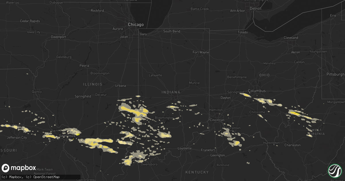
Hail Map in Indiana on July 22, 2017
Get this storm
July 22 map
$229
one time, instant access
Download today. No call, no setup
Keep the $229
Bought the map and want the full workflow? Apply the entire $229 to a subscription within 7 days. None of it is wasted.
Every map, not just this one
This buys you this map. Subscription and you get every map we run, in the markets you choose from a few cities to whole states to nationwide. Plus real-time alerts the moment a storm fires.
Contact data
Name, contact info, occupancy, even credit band for addresses in the footprint. You go from where it hit to who to call.
Become the source they trust
Unlimited branding weather history reports on demand. You already have the documented answer ready for the property owner, and you are the one who showed up with it.
Property data and RoofTrace estimates
Pull up any address you have got, its value and the exact code rules for that jurisdiction, straight from One Click Code. Then RoofTrace estimates the squares, pitch, and roof value, priced the way you price.
Storm reports in Indiana
Indiana
| Date | Description |
|---|---|
| 07/22/20176:37 AM CDT | Trees down in town. Late report |
| 07/22/20176:37 AM CDT | Numerous trees down across the northern part of the county. Interstate 64 was blocked for a time. Dale and areas east of tennyson were significantly impacted. |
| 07/22/20176:15 AM CDT | Trees down... And road signs blown off the road. |
| 07/22/20176:02 AM CDT | Emergency manager reports a tree down near old us 50 and hyde park drive. Time estimated from radar. |
| 07/22/20176:00 AM CDT | Emergency manager reports large tree down near intersection of 3rd st and shelby st in vincennes. Time estimated from radar. |
| 07/22/20175:47 AM CDT | Multiple trees and limbs down just north of owensville. |
| 07/22/20175:15 AM CDT | Trees down... And road signs blown off the road. |
| 07/22/20172:15 AM CDT | A few trees down. |
| 07/22/20172:09 AM CDT | One tree down. |
| 07/22/20172:04 AM CDT | One tree down. |
| 07/22/20171:22 AM CDT | Tree down. |
| 07/22/201712:31 AM CDT | Trees down...power pole down. |
| 07/22/201712:31 AM CDT | Trees down...power pole down. |
| 07/21/20177:40 PM CDT | Multiple trees downed across shakamak state park. Delayed report from july 22 storm. Time estimated from radar. |
All States Impacted by Hail Map on July 22, 2017
Cities Impacted by Hail Map on July 22, 2017
- Green Bay, WI
- Coxs Mills, WV
- Troy, WV
- Nashville, IL
- Carlyle, IL
- Walnut Hill, IL
- Bartelso, IL
- Okawville, IL
- Dix, IL
- Hoyleton, IL
- Centralia, IL
- Kell, IL
- Steedman, MO
- Hill City, KS
- Ogallah, KS
- Wakeeney, KS
- Ellis, KS
- Wakefield, KS
- Milford, KS
- Havensville, KS
- Onaga, KS
- Soldier, KS
- Delia, KS
- Parkersburg, WV
- Belpre, OH
- Vienna, WV
- Saint Albans, MO
- Wildwood, MO
- Pacific, MO
- Orr, MN
- Truxton, MO
- Bellflower, MO
- Mascoutah, IL
- New Baden, IL
- Ville Platte, LA
- Washington, LA
- Raymore, MO
- Lees Summit, MO
- Pleasant Hill, MO
- Greenwood, MO
- Kansas City, MO
- Casco, WI
- Luxemburg, WI
- Fulton, MO
- Plainville, KS
- Natoma, KS
- Stockton, KS
- Woodston, KS
- Wadesville, IN
- Waverly, KY
- Corydon, KY
- Uniontown, KY
- Mount Vernon, IN
- Morganfield, KY
- Evansville, IN
- Overbrook, KS
- Baldwin City, KS
- Lawrence, KS
- North, VA
- La Monte, MO
- Sedalia, MO
- Hermann, MO
- Cape Charles, VA
- Duck, WV
- Frametown, WV
- Versailles, IN
- Cross Plains, IN
- Dillsboro, IN
- Amarillo, TX
- Chandler, IN
- Middletown, MO
- Terre Haute, IN
- Brazil, IN
- Nunn, CO
- Hayward, WI
- Winter, WI
- Ojibwa, WI
- Warrensburg, MO
- Council Grove, KS
- Alta Vista, KS
- Collyer, KS
- Laurelville, OH
- Burnsville, WV
- Hazel Green, KY
- Mize, KY
- Gillett, WI
- Albert, KS
- Olmitz, KS
- Otis, KS
- Hoisington, KS
- Decker, IN
- Mount Carmel, IL
- Allendale, IL
- Wamego, KS
- Belvue, KS
- Belleville, IL
- Millstadt, IL
- Damar, KS
- Cawker City, KS
- Mount Vernon, IL
- Opdyke, IL
- Pulaski, WI
- Seymour, WI
- Mount Olivet, KY
- Forestville, WI
- Brussels, WI
- Algoma, WI
- Circleville, OH
- Stoutsville, OH
- Amanda, OH
- Lancaster, OH
- Ashville, OH
- Clifton, AZ
- Morenci, AZ
- Barrington, NJ
- Somerdale, NJ
- Collingswood, NJ
- Magnolia, NJ
- Audubon, NJ
- Oaklyn, NJ
- Haddonfield, NJ
- Haddon Heights, NJ
- Medford, NJ
- Lawnside, NJ
- Philadelphia, PA
- Gibbsboro, NJ
- Bellmawr, NJ
- Mount Ephraim, NJ
- Cherry Hill, NJ
- Vincentown, NJ
- Gloucester City, NJ
- Marlton, NJ
- Voorhees, NJ
- Camden, NJ
- Mountain, WI
- White Lake, WI
- Sumner, IL
- Emmett, KS
- Palestine, IL
- Charleston, IL
- Ashmore, IL
- Casey, IL
- West Union, IL
- Kansas, IL
- Lewis, IN
- Cory, IN
- Oakland, IL
- Merom, IN
- Worthington, IN
- Clay City, IN
- Sullivan, IN
- Riley, IN
- Greenup, IL
- Coalmont, IN
- Shelburn, IN
- Marshall, IL
- Robinson, IL
- Mattoon, IL
- Carlisle, IN
- Dennison, IL
- Jasonville, IN
- West York, IL
- Farmersburg, IN
- Switz City, IN
- Hymera, IN
- Centerpoint, IN
- Pimento, IN
- Westfield, IL
- Lerna, IL
- Martinsville, IL
- Hutsonville, IL
- Fairbanks, IN
- West Terre Haute, IN
- Alma, KS
- Minneapolis, KS
- Portland, MO
- Hillsboro, KY
- Moorefield, KY
- Wallingford, KY
- Mayslick, KY
- Ewing, KY
- Carlisle, KY
- Flemingsburg, KY
- Laddonia, MO
- Perry, MO
- Paris, IL
- Pilot Mountain, NC
- Huntington, WV
- New Richmond, OH
- Harrisville, WV
- Cairo, WV
- Chamois, MO
- Huntingburg, IN
- Maryville, IL
- Troy, IL
- Highland, IL
- Collinsville, IL
- Edwardsville, IL
- Granite City, IL
- Glen Carbon, IL
- Saint Jacob, IL
- Lebanon, IL
- Little Hocking, OH
- Walker, WV
- Vincent, OH
- Davisville, WV
- Cutler, OH
- Milroy, IN
- Rushville, IN
- Falmouth, KY
- Odessa, MO
- Lancaster, VA
- Nineveh, IN
- Bargersville, IN
- Morgantown, IN
- Franklin, IN
- Martinsville, IN
- Trafalgar, IN
- Olsburg, KS
- Westmoreland, KS
- Defiance, MO
- Augusta, MO
- Marthasville, MO
- Ness City, KS
- Marion, LA
- Columbia, MO
- Richmond Dale, OH
- Chillicothe, OH
- French Lick, IN
- Dubois, IN
- Townsend, WI
- Suring, WI
- Holton, KS
- Saint Marys, KS
- Corning, KS
- Mayetta, KS
- Hoyt, KS
- Columbus, IN
- Nashville, IN
- Dry Ridge, KY
- Williamstown, KY
- Willow Hill, IL
- Crane Lake, MN
- Dunnsville, VA
- Center Cross, VA
- Tappahannock, VA
- Saint Peters, MO
- Saint Charles, MO
- Cincinnati, OH
- Crittenden, KY
- O'Fallon, IL
- Lac Du Flambeau, WI
- Park Falls, WI
- Eskridge, KS
- Williamstown, WV
- Marietta, OH
- Clay Center, KS
- Spottsville, KY
- Reed, KY
- Henderson, KY
- Little Plymouth, VA
- Urbanna, VA
- Mascot, VA
- Church View, VA
- Walsenburg, CO
- Paoli, IN
- West Baden Springs, IN
- Orleans, IN
- Beaufort, MO
- Morton, TX
- Boonville, MO
- Browns, IL
- Bellmont, IL
- Hindsboro, IL
- Palestine, WV
- Mount Sterling, OH
- London, OH
- Albion, IL
- Rising Sun, IN
- Pullman, WV
- Berea, WV
- Auburn, WV
- Valley Falls, KS
- Hawk Point, MO
- Silex, MO
- High Hill, MO
- Campbellsburg, IN
- Mount Laurel, NJ
- Moorestown, NJ
- Camden, WV
- Washington, WV
- Knott, TX
- Longford, KS
- Mocksville, NC
- McArthur, OH
- Creola, OH
- South Bloomingville, OH
- Addieville, IL
- Richview, IL
- Woodlawn, IL
- Ashley, IL
- Ashland, MO
- Patoka, IN
- Grainfield, KS
- Urich, MO
- West Salem, WI
- Mindoro, WI
- Bloomfield, IN
- Harveyville, KS
- Burlingame, KS
- Abilene, KS
- Chapman, KS
- Washington, IN
- Montgomery, IN
- Saint Marys, WV
- Waverly, WV
- Curryville, MO
- Vandalia, MO
- Loogootee, IN
- Shoals, IN
- Maple Hill, KS
- Topeka, KS
- Paxico, KS
- Wheeler, IL
- Newton, IL
- Dieterich, IL
- Marengo, IN
- Morganton, NC
- Collettsville, NC
- Peculiar, MO
- Freeman, MO
- Olney, IL
- Edinburgh, IN
- Flat Rock, IN
- Jackson, OH
- Wellston, OH
- Lone Jack, MO
- Oak Grove, MO
- Downs, KS
- Goreville, IL
- Annapolis, IL
- Oblong, IL
- Weston, WV
- Springville, IN
- Hardinsburg, IN
- Mason, IL
- Saint Elmo, IL
- Altamont, IL
- Texico, IL
- Bluford, IL
- Iuka, IL
- Johnsonville, IL
- Keenes, IL
- Sims, IL
- Mayview, MO
- Blue Rapids, KS
- Randolph, KS
- Commiskey, IN
- Seymour, IN
- Fort Mcdowell, AZ
- Orient, OH
- Marengo, WI
- High Bridge, WI
- West Salem, IL
- Chrisman, IL
- Dana, IN
- Vanceburg, KY
- Aberdeen, OH
- Manchester, OH
- Winston Salem, NC
- Stanton, TX
- Chesterfield, MO
- Concordia, MO
- Watson, IL
- Phillips, WI
- Lovington, NM
- Villa Ridge, MO
- Cisne, IL
- Mitchell, IN
- Bates City, MO
- Haleyville, AL
- Russellville, AL
- Moulton, AL
- Wellsville, MO
- Marietta, MS
- Booneville, MS
- Sigourney, IA
- Bremen, OH
- Sugar Grove, OH
- Logan, OH
- Belle Rive, IL
- Owensboro, KY
- Jasper, IN
- Effingham, IL
- Bonnie, IL
- Macedonia, IL
- Albers, IL
- Wayne City, IL
- Irvington, IL
- Ina, IL
- Hoffman, IL
- McLeansboro, IL
- Waltonville, IL
- Dahlgren, IL
- Springerton, IL
- Enfield, IL
- Du Bois, IL
- Clinton, MO
- Simpson, IL
- Saint Louis, MO
- Owensville, IN
- Mount Erie, IL
- Golden Gate, IL
- Bone Gap, IL
- Fairfield, IL
- Ellery, IL
- Brocton, IL
- Vincennes, IN
- Earlysville, VA
- Free Union, VA
- Dyke, VA
- Suamico, WI
- Sobieski, WI
- Newport, OH
- Reno, OH
- Magdalena, NM
- Whiteland, IN
- Greenwood, IN
- Mill Shoals, IL
- Barnhill, IL
- Labadie, MO
- Midland, TX
- Tishomingo, MS
- Newburgh, IN
- Williams, IN
- Bedford, IN
- Upson, WI
- Redmon, IL
- Mexico, MO
- Santa Fe, MO
- Hiram, GA
- Dallas, GA
- Greensburg, IN
- Coolville, OH
- Parkersburg, IL
- Calhoun, IL
- Saint Francisville, IL
- Bridgeport, IL
- Claremont, IL
- Alton, KS
- Sudan, TX
- Enochs, TX
- Morland, KS
- Chloe, WV
- Nebo, WV
- Plainville, IN
- La Grange, KY
- Keyes, OK
- Morehead, KY
- Owingsville, KY
- Delphos, KS
- Amesville, OH
- Chesterhill, OH
- Church Hill, TN
- Hartford, IL
- South Roxana, IL
- East Alton, IL
- New Harmony, IN
- Foster, KY
- Brooksville, KY
- Sylvan Grove, KS
- Beloit, KS
- Barnard, KS
- Hunter, KS
- Ferdinand, IN
- Saint Paul, IN
- Harrisonville, MO
- Archie, MO
- Tipton, KS
- Glen Elder, KS
- Batavia, OH
- Atchison, KS
- Garrison, KY
- Junction City, OH
- Quinter, KS
- Shelbyville, IN
- Madison, IN
- Canaan, IN
- Bristow, IN
- Glenwood, IN
- Connersville, IN
- Manilla, IN
- Solsberry, IN
- Hanston, KS
- Willcox, AZ
- Wooldridge, MO
- Rocheport, MO
- Couderay, WI
- Lamar, IN
- Olathe, KS
- New Century, KS
- Monroe City, IN
- Wheatland, IN
- Whiting, KS
- Muscotah, KS
- Lexington, MO
- Wellington, MO
- Sweet Springs, MO
- Franklin, LA
- Gaylord, KS
- Linton, IN
- Green Castle, MO
- Lenzburg, IL
- Clovis, NM
- Cannel City, KY
- West Liberty, KY
- Rarden, OH
- Peebles, OH
- Mineral Wells, WV
- Gove, KS
- Goshen, OH
- Pleasant Plain, OH
- Manhattan, KS
- Portis, KS
- Butler, MO
- Prairie Home, MO
- Lincoln, KS
- Mount Airy, NC
- Oskaloosa, IA
- Rose Hill, IA
- Capron, VA
- Courtland, VA
- Osage City, KS
- Harris, MO
- Princeton, MO
- Newtown, MO
- Hughesville, MO
- Columbia, IL
- Dupo, IL
- East Carondelet, IL
- Bloomington, IN
- Oaktown, IN
- Lawrenceville, IL
- Tollesboro, KY
- Hoxie, KS
- Como, NC
- Newsoms, VA
- Suffolk, VA
- De Mossville, KY
- Frankfort, KS
- Richland, IN
- Rockport, IN
- Monroe, VA
- Amherst, VA
- Madison Heights, VA
- Alum Bridge, WV
- New Milton, WV
- Fleming, OH
- Petroleum, WV
- West Union, WV
- Eureka, KS
- Big Spring, TX
- Odon, IN
- Lyons, IN
- Sandborn, IN
- Crane, IN
- Elnora, IN
- Newberry, IN
- Higginsville, MO
- Corder, MO
- Hedrick, IA
- Delta, IA
- Boonville, IN
- Poseyville, IN
- Haubstadt, IN
- Omaha, IL
- Ridgway, IL
- Elberfeld, IN
- New Haven, IL
- Carmi, IL
- Grain Valley, MO
- Blue Springs, MO
- Bunceton, MO
- Smithton, MO
- Otterville, MO
- Cleveland, MO
- Grandview, MO
- Belton, MO
- Colonial Beach, VA
- Champlain, VA
- Montross, VA
- Williamsburg, MO
- Hamersville, OH
- Walker, LA
- Farina, IL
- Warrenton, MO
- Holden, MO
- Kingsville, MO
- Glouster, OH
- Glade Hill, VA
- Green City, MO
- Blackwater, MO
- Jamaica, VA
- Grantsville, WV
- Glenville, WV
- Big Springs, WV
- Normantown, WV
- Warsaw, VA
- Cairo, MO
- Moberly, MO
- Denison, KS
- Lynnville, IN
- Eudora, KS
- Salt Rock, WV
- Kennesaw, GA
- Marietta, GA
- Washington, MO
- Georgetown, KY
- Smithville, WV
- Bay Minette, AL
- Stockton, AL
- Morrison, MO
- Wentzville, MO
- Melrose, NM
- Whipple, OH
- Junction, IL
- Adrian, MO
- Boykins, VA
- Kahoka, MO
- Yorktown, VA
- West Liberty, IL
- Marion, NC
- Spotsylvania, VA
- Old Monroe, MO
- Moscow Mills, MO
- Fairchild, WI
- Osseo, WI
- Odessa, TX
- Iuka, MS
- Oakland City, IN
- Marshall, MO
- Nelson, MO
- Oakdale, IL
- Houstonia, MO
- Elizabeth, WV
- Macfarlan, WV
- New Haven, MO
- Foristell, MO
- Ballwin, MO
- Wright City, MO
- Eureka, MO
- Roxana, IL
- Olive Hill, KY
- Stilwell, KS
- Overland Park, KS
- Westfield, NC
- Pinnacle, NC
- Saint Anthony, IN
- Celestine, IN
- Gail, TX
- Montrose, MO
- Gardner, KS
- Branchville, VA
- Margarettsville, NC
- Cannelburg, IN
- Pilot Grove, MO
- Lockbourne, OH
- Slater, MO
- Fairland, IN
- Needham, IN
- Indianapolis, IN
- Boggstown, IN
- Bennington, KS
- Smithville, MO
- Edgerton, KS
- Wellsville, KS
- Houston, TX
- Clinton, IN
- English, IN
- Belmont, MS
- Noble, IL
- Smyrna, GA
- Auxvasse, MO
- Germantown, KY
- Maysville, KY
- Patricksburg, IN
- Spencer, IN
- Bowling Green, IN
- Coal City, IN
- Freedom, IN
- Horton, KS
- Maryland Heights, MO
- Saint Ann, MO
- Mannington, WV
- Krakow, WI
- Oneida, WI
- Little Suamico, WI
- Batesville, IN
- Creston, WV
- Mount Zion, WV
- Chrisney, IN
- Farber, MO
- Dale, IN
- Gentryville, IN
- Flat Rock, IL
- Wakarusa, KS
- Butler, KY
- Huntsville, MO
- Rockport, WV
- Otwell, IN
- Sunman, IN
- Birdseye, IN
- Waterford, OH
- Gower, MO
- Fayette, MO
- Sanders, KY
- Ghent, KY
- Vevay, IN
- Carrollton, KY
- Patriot, IN
- New Straitsville, OH
- Ottawa, KS
- Pomona, KS
- Linn, WV
- Ellettsville, IN
- Gosport, IN
- Farnham, VA
- Wichita, KS
- Dwight, KS
- Sardinia, OH
- Mount Orab, OH
- Bethel, OH
- Tennyson, IN
- Tell City, IN
- Santa Claus, IN
- Evanston, IN
- West Jefferson, OH
- Effingham, KS
- Sunbury, NC
- Mokane, MO
- New Bloomfield, MO
- Rhineland, MO
- Clemmons, NC
- Lewisville, NC
- Austell, GA
- Ripley, OH
- Bucyrus, KS
- Orma, WV
- Rosedale, WV
- Moscow, OH
- Felicity, OH
- California, KY
- Neville, OH
- Augusta, KY
- Georgetown, OH
- Ely, MN
- Park, KS
- Berryton, KS
- Bicknell, IN
- Bruceville, IN
- Ragsdale, IN
- Reedsville, OH
- Dover, KY
- Rosedale, IN
- Garden City, MO
- Saint Clair, MO
- Napoleon, MO
- Palco, KS
- Holt, MO
- Trimble, MO
- Annada, MO
- Geff, IL
- Keshena, WI
- Williamsport, OH
- Waverly, MO
- Dover, MO
- Auburn, KS
- Millstone, WV
- Arnoldsburg, WV
- Gassaway, WV
- Shock, WV
- Heflin, AL
- Dundas, IL
- Utica, KS
- Winfield, MO
- Cummings, KS
- Lancaster, KS
- Portales, NM
- Winslow, IN
- Petersburg, IN
- South Charleston, OH
- Daytona Beach, FL
- Lansdowne, PA
- Circleville, KS
- Holden, LA
- Peridot, AZ
- New Florence, MO
- Chilhowee, MO
- Lowell, OH
- Brewton, AL
- Tescott, KS
- Stendal, IN
- Melbourne, FL
- Leawood, KS
- Alma Center, WI
- New Franken, WI
- De Pere, WI
- Denmark, WI
- Hazelwood, MO
- Madison, IL
- Marine, IL
- Bridgeton, MO
- Florissant, MO
- Wood River, IL
- Newton, KS
- Floyd, NM
- Arcola, IL
- Franklin, MO
- Glasgow, MO
- Murray City, OH
- Rockbridge, OH
- Nelsonville, OH
- Trenton, IL


