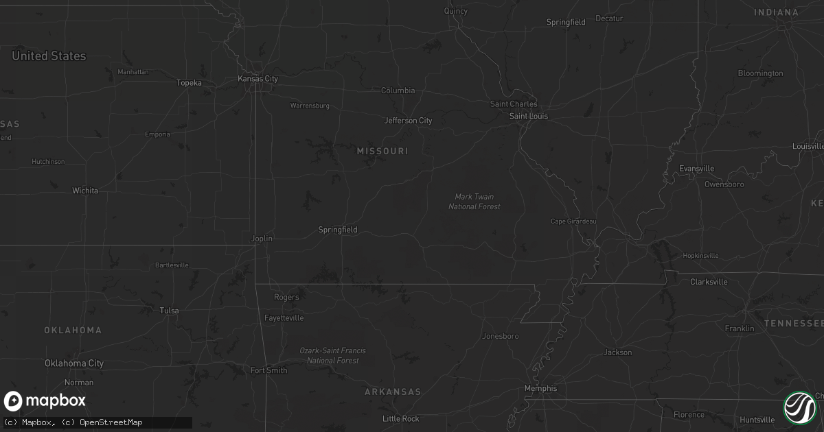
Hail Map in Texas on July 21, 2012
Get this storm
July 21 map
$229
one time, instant access
Download today. No call, no setup
Keep the $229
Bought the map and want the full workflow? Apply the entire $229 to a subscription within 7 days. None of it is wasted.
Every map, not just this one
This buys you this map. Subscription and you get every map we run, in the markets you choose from a few cities to whole states to nationwide. Plus real-time alerts the moment a storm fires.
Contact data
Name, contact info, occupancy, even credit band for addresses in the footprint. You go from where it hit to who to call.
Become the source they trust
Unlimited branding weather history reports on demand. You already have the documented answer ready for the property owner, and you are the one who showed up with it.
Property data and RoofTrace estimates
Pull up any address you have got, its value and the exact code rules for that jurisdiction, straight from One Click Code. Then RoofTrace estimates the squares, pitch, and roof value, priced the way you price.
Storm reports in Texas
Texas
| Date | Description |
|---|---|
| 07/21/20126:55 PM CDT | Tree reported down on a house in tyler. |
| 07/21/20126:35 PM CDT | Trees reported down near tenaha. |
| 07/21/20126:15 PM CDT | Trees down in mount enterprise. |
| 07/21/20126:12 PM CDT | Several trees down on cr2506 and cr2141 between wallace and phalba |
| 07/21/20126:10 PM CDT | Quarter sized hail was reported near timpson. |
| 07/21/20126:06 PM CDT | Trees down on fm 15 n of hwy 64...one tree was about 3 feet in diameter. |
| 07/21/20125:48 PM CDT | At lebanon and the tollway. Also pea hail. |
| 07/21/20125:45 PM CDT | Gas station sign blown down near eldorado and the north dallas tollway in frisco |
| 07/20/201210:53 PM CDT | Tree down on ranch acres road near intersection with fm 1375. |
| 07/20/201210:45 PM CDT | Trees down on stringtown road. |
| 07/20/201210:42 PM CDT | Trees down near 150 and fm 2693. Vehicle struck a fallen tree on fm2693...very minor injuries to the driver. |
| 07/20/201210:33 PM CDT | Trees down on fm 2666. |
| 07/20/201210:27 PM CDT | Trees down huffman creek and fm 222 area. |
| 07/20/201210:25 PM CDT | Trees down in onalaska |
| 07/20/201210:25 PM CDT | Trees down in blanchard along fm 2457. |
| 07/20/201210:25 PM CDT | Lots of trees down in corrigan. |
| 07/20/201210:20 PM CDT | Powerlines down and transformers blown in point blank. |
| 07/20/201210:15 PM CDT | Trees down near fm980. |
| 07/20/20129:58 PM CDT | A few trees down in leggett. |
| 07/20/20129:37 PM CDT | Numerous trees down across town and power outages. |
| 07/20/20129:36 PM CDT | Large tree limbs reported down in diboll. |
| 07/20/20129:20 PM CDT | Trees were knocked down in crossroads. |
| 07/20/20129:16 PM CDT | Tree limbs down on highway 94 |
| 07/20/20129:16 PM CDT | Trees downed on fm2501 |
| 07/20/20129:07 PM CDT | Numerous trees down. |
| 07/20/20129:07 PM CDT | Trees and power lines reported down across the entire county. |
| 07/20/20129:01 PM CDT | Trees downed near fm 227 |
| 07/20/20128:55 PM CDT | Quarter sized hail in henderson. |
| 07/20/20128:50 PM CDT | Multiple trees down across the southern end of the county. |
| 07/20/20128:47 PM CDT | Quarter hail near poynor |
| 07/20/20128:47 PM CDT | Tree down in lufkin. |
| 07/20/20128:35 PM CDT | Trees down on highway 59 north of lufkin. |
| 07/20/20128:25 PM CDT | Trees and power lines down in rusk and across the county. |
| 07/20/20128:02 PM CDT | Many trees were knocked down in frankston. |
| 07/20/20127:50 PM CDT | Trees down in jacksonville. |
| 07/20/20127:44 PM CDT | Trees down across the city of jacksonville. |
| 07/20/20127:30 PM CDT | Trees down across the county. |
| 07/20/20127:20 PM CDT | Trees down in the frankston area. |
| 07/20/20127:08 PM CDT | Trees down. |
| 07/20/20127:01 PM CDT | Quarter sized hail reported in the community of grisby. |
| 07/20/20127:00 PM CDT | Trees were blown down in the woodland hills neighborhood in tyler. |
| 07/20/20127:00 PM CDT | Trees down on highway 138 outside of center. |
All States Impacted by Hail Map on July 21, 2012
Cities Impacted by Hail Map on July 21, 2012
- Center, TX
- San Augustine, TX
- Nacogdoches, TX
- Mebane, NC
- Castalia, NC
- Saint James, MN
- Vinton, LA
- Sulphur, LA
- Timpson, TX
- Garrison, TX
- Joaquin, TX
- Carthage, TX
- Tenaha, TX
- Wallace, NC
- Williston, ND
- Marshall, TX
- Nemo, SD
- Upton, WY
- Newcastle, WY
- Larue, TX
- Wounded Knee, SD
- Pine Ridge, SD
- Stonewall, LA
- Batesland, SD
- Lumberton, NC
- Waskom, TX
- Hill City, SD
- Custer, SD
- Safety Harbor, FL
- Clearwater, FL
- Dover, NC
- Henderson, TX
- Laneville, TX
- Price, TX
- Mount Enterprise, TX
- Alto, TX
- Wells, TX
- Pollok, TX
- Wibaux, MT
- Doyline, LA
- Haughton, LA
- Eden, NC
- Stoneville, NC
- Harrells, NC
- Willard, NC
- Lambert, MT
- Westlake, LA
- Lake Charles, LA
- Beulah, WY
- Sundance, WY
- Engelhard, NC
- Douglass, TX
- Gary, TX
- Deadwood, SD
- Chandler, TX
- Lead, SD
- Pendleton, NC
- Como, NC
- Bushnell, FL
- Brooksville, FL
- Floral City, FL
- Rusk, TX
- Elm Grove, LA
- Shreveport, LA
- Gloster, LA
- Converse, LA
- Grand Cane, LA
- Frierson, LA
- Mansfield, LA
- Four Oaks, NC
- Rapid City, SD
- Rowland, NC
- Maxton, NC
- Fairview, MT
- Sidney, MT
- Lutz, FL
- Tampa, FL
- Cheyenne, WY
- Glasgow, MT
- Kennard, TX
- Logansport, LA
- Malakoff, TX
- Athens, TX
- Winnett, MT
- Zebulon, NC
- Wheatland, WY
- Aydlett, NC
- Coinjock, NC
- Barco, NC
- Bossier City, LA
- Hay Springs, NE
- Crane, MT
- Cartwright, ND
- Savage, MT
- Keithville, LA
- Kerens, TX
- Jefferson, SC
- Karnack, TX
- Reidsville, NC
- Summerfield, NC
- Branford, FL
- Beckville, TX
- Rushville, NE
- Elon, NC
- Blanch, NC
- Pelham, NC
- Providence, NC
- Yanceyville, NC
- Ruffin, NC
- Centerville, TX
- Hildebran, NC
- Connelly Springs, NC
- Powers Lake, ND
- Musselshell, MT
- Custer, MT
- Ingomar, MT
- Crosby, ND
- Mcgregor, ND
- Whitehouse, TX
- Troup, TX
- Corrigan, TX
- Weldon, NC
- Garysburg, NC
- Jacksonville, TX
- Dade City, FL
- Hartsville, SC
- Darlington, SC
- Littleton, NC
- Tyler, TX
- Wildrose, ND
- Lufkin, TX
- Liberty, NC
- Gainesville, GA
- Pembroke, NC
- Denton, NC
- Lexington, NC
- Thomasville, NC
- Trinity, NC
- Hampstead, NC
- Bullard, TX
- Pink Hill, NC
- Deep Run, NC
- Albertson, NC
- Mount Olive, NC
- Kinston, NC
- Martin, SD
- Long Valley, SD
- Bailey, NC
- Middlesex, NC
- Groveton, TX
- Pennington, TX
- Gibsonville, NC
- Lucan, MN
- Milroy, MN
- Walnut Grove, MN
- Vesta, MN
- Ghent, MN
- Minneota, MN
- Taunton, MN
- Marshall, MN
- Cottonwood, MN
- Kenansville, NC
- Warsaw, NC
- Bell, FL
- Knotts Island, NC
- Virginia Beach, VA
- Emporia, VA
- Opheim, MT
- Peerless, MT
- Apple Springs, TX
- Randleman, NC
- Long Branch, TX
- Spearfish, SD
- Piedmont, SD
- Sturgis, SD
- Hammond, MT
- Capitol, MT
- Lewiston Woodville, NC
- Bennettsville, SC
- Society Hill, SC
- Dillon, SC
- McColl, SC
- Little Rock, SC
- Hamer, SC
- Clio, SC
- Sims, NC
- Kenly, NC
- Grenora, ND
- Palestine, TX
- Frankston, TX
- Havelock, NC
- Buffalo Gap, SD
- Cushing, TX
- Clinton, NC
- Turkey, NC
- Faison, NC
- Statesville, NC
- Tennessee Colony, TX
- McBee, SC
- Canton, TX
- Wills Point, TX
- Blenheim, SC
- Punta Gorda, FL
- North Fort Myers, FL
- Merry Hill, NC
- Ahoskie, NC
- Mayodan, NC
- Lamberton, MN
- Bethune, SC
- Siler City, NC
- Pittsboro, NC
- Edgemont, SD
- Chireno, TX
- Dequincy, LA
- Osage, WY
- Hawthorne, FL
- Hollister, NC
- Macon, NC
- Warrenton, NC
- Oak City, NC
- Hobgood, NC
- Bainville, MT
- Culbertson, MT
- Singer, LA
- Leasburg, NC
- High Point, NC
- Browns Summit, NC
- Allen, SD
- Durango, CO
- Redwood Falls, MN
- Wabasso, MN
- Pleasant Hill, NC
- Spring Hope, NC
- Garrett, WY
- Diboll, TX
- Cape Coral, FL
- Woodland, NC
- Murfreesboro, NC
- Kelford, NC
- Aulander, NC
- Conway, NC
- Meadville, MS
- Fortuna, ND
- Vanceboro, NC
- Columbus, ND
- Springfield, MN
- Linwood, NC
- Gateway, CO
- Whitewater, CO
- Henderson, NC
- Louisburg, NC
- Montalba, TX
- Huntington, TX
- Nashua, MT
- Land O'Lakes, FL
- Keatchie, LA
- Jacksonville, NC
- Wanblee, SD
- Norris, SD
- Parmelee, SD
- Porcupine, SD
- Burlington, NC
- Haw River, NC
- Bradenton, FL
- Ellenton, FL
- Morgan, MN
- Ivanhoe, MN
- Echo, MN
- Wanda, MN
- Sanborn, MN
- Tracy, MN
- Seaforth, MN
- Wood Lake, MN
- Belview, MN
- Clements, MN
- Elizabethtown, NC
- Newsoms, VA
- Oldsmar, FL
- Palm Harbor, FL
- Lance Creek, WY
- Scotland Neck, NC
- Brownsboro, TX
- Ocala, FL
- Anthony, FL
- Harrison, NE
- Seven Springs, NC
- La Grange, NC
- Pelican, LA
- Naper, NE
- Parrish, FL
- Grifton, NC
- Boykins, VA
- Spring Hill, FL
- Trenton, FL
- Jennings, LA
- Ambrose, ND
- Springview, NE
- Beulaville, NC
- Monroe, NC
- Lehigh Acres, FL
- Newton Grove, NC
- Julian, NC
- Graham, NC
- Enfield, NC
- Roanoke Rapids, NC
- Halifax, NC
- Elkhart, TX
- Iowa, LA
- Nobleton, FL
- Hotevilla, AZ
- Pinon, AZ
- Grand Chenier, LA
- Creole, LA
- McLeansville, NC
- Malta, ID
- Trenton, NC
- Reeves, LA
- Kinder, LA
- Cascade, VA
- Hookerton, NC
- Selma, NC
- Colerain, NC
- Winston Salem, NC
- Saint Francis, SD
- Hertford, NC
- North Port, FL
- Stony Point, NC
- Claremont, NC
- Ignacio, CO
- Norlina, NC
- Meeker, CO
- Jackson, NC
- Chiefland, FL
- Youngsville, NC
- Hahira, GA
- Jelm, WY
- Ellerbe, NC
- Crowley, LA
- Morse, LA
- Buford, GA
- Richlands, NC
- Chinquapin, NC
- Buffalo, TX
- Oakwood, TX
- Normangee, TX
- Port Arthur, TX
- Groves, TX
- Miami, FL
- Wildwood, FL
- Oxford, FL
- Nashville, NC
- Alamo, ND
- Roxobel, NC
- Dudley, NC
- Chimayo, NM
- Clearwater Beach, FL
- Lake City, FL
- Climax, NC
- White River, SD
- Poplar Branch, NC
- Grandy, NC
- Kershaw, SC
- Patrick, SC
- Flint, TX
- Wimauma, FL
- Riverview, FL
- Clemmons, NC
- Keystone, SD
- Dulce, NM
- Frostproof, FL
- Snow Camp, NC
- Columbia, SC
- Asheboro, NC
- Zavalla, TX
- Magnolia, NC
- Reklaw, TX
- New Ulm, MN
- Cheraw, SC
- Morven, NC
- Labelle, FL
- Elgin, SC
- Hanska, MN
- Cameron, LA
- Bell City, LA
- Chapel Hill, NC
- Old Town, FL
- Camden, SC
- Sarasota, FL
- Hubert, NC
- Merryville, LA
- Windsor, NC
- Skippers, VA
- Gaston, NC
- Minden, LA
- Cotton Valley, LA
- Valdese, NC
- Kernersville, NC
- Park Valley, UT
- Belleview, FL
- Cofield, NC
- Manderson, SD
- Shelbyville, TX
- Benson, NC
- Halifax, VA
- Scottsburg, VA
- Immokalee, FL
- Laramie, WY


