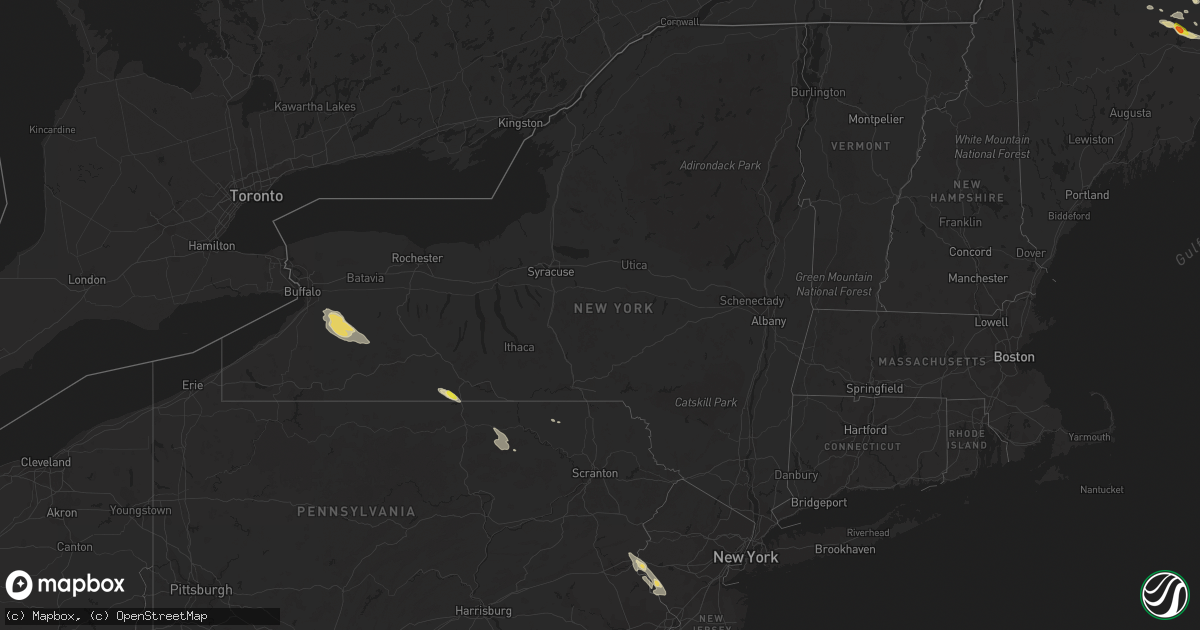
Hail Map in New York on July 20, 2017
Get this storm
July 20 map
$229
one time, instant access
Download today. No call, no setup
Keep the $229
Bought the map and want the full workflow? Apply the entire $229 to a subscription within 7 days. None of it is wasted.
Every map, not just this one
This buys you this map. Subscription and you get every map we run, in the markets you choose from a few cities to whole states to nationwide. Plus real-time alerts the moment a storm fires.
Contact data
Name, contact info, occupancy, even credit band for addresses in the footprint. You go from where it hit to who to call.
Become the source they trust
Unlimited branding weather history reports on demand. You already have the documented answer ready for the property owner, and you are the one who showed up with it.
Property data and RoofTrace estimates
Pull up any address you have got, its value and the exact code rules for that jurisdiction, straight from One Click Code. Then RoofTrace estimates the squares, pitch, and roof value, priced the way you price.
Storm reports in New York
New York
| Date | Description |
|---|---|
| 07/20/20176:10 PM CDT | Road closed from live wire and downed tree near shenandoah road and jackson road. |
| 07/20/20176:10 PM CDT | Tree branch and power line wires down on long hill road. |
| 07/20/20173:07 PM CDT | Wires down across the roadway in the vicinity of tutlle hill rd. |
| 07/20/20173:04 PM CDT | Tree down across elmira st. |
| 07/20/20172:42 PM CDT | Tree down across rt 13 at county line. |
| 07/20/20172:21 PM CDT | Tree down over power lines in the vicinity of 1350 tioughanack blvd. |
| 07/20/20172:21 PM CDT | Tree fell on house on college ave. |
| 07/20/20172:15 PM CDT | Numerous large trees down in lawrenceville. |
| 07/20/20172:13 PM CDT | Roof partially blown off house on ryon circle. |
| 07/20/20172:10 PM CDT | Tree down over power lines in the vicinity of 1616 co. Rd. 85. |
| 07/20/20172:05 PM CDT | A local report indicates 66 MPH wind near ADDISON |
| 07/20/20172:00 PM CDT | Numerous trees down. |
| 07/20/20172:00 PM CDT | Tree down across power lines on county route 7. |
| 07/20/20172:00 PM CDT | Numerous trees down. Boat lifted up and blowin across road. |
| 07/20/20171:53 PM CDT | Tree down across hwy 417 near banks hollow blocking both lanes. |
| 07/20/20171:47 PM CDT | Tree fell on a car near allegany fairgrounds |
| 07/20/20171:35 PM CDT | Trees and wires down |
| 07/20/20171:25 PM CDT | Tree down in hartsville. |
| 07/20/20171:04 PM CDT | Trees down on creek rd. In town of yorkshire. |
| 07/20/20171:02 PM CDT | Tree down at beech tree rd and hwy 240. |
| 07/20/201712:54 PM CDT | Barn blown down along county route 16 near dowd rd. |
| 07/20/201712:46 PM CDT | Numerous trees down near county route 15 and old state road. |
| 07/20/201712:42 PM CDT | Trees down on holiday road. |
| 07/20/201712:40 PM CDT | Storm survey confirmed ef1 tornado. Several homes were damaged and a barn severely damaged. Several sheds or small outbuildings were tipped and moved. Numerous large tr |
| 07/20/201712:35 PM CDT | Snapped electric poles...trees and wires down counsil house rd |
| 07/20/201712:35 PM CDT | Trees and wires down |
| 07/20/201712:27 PM CDT | Trees down on mills road. |
| 07/20/201712:24 PM CDT | Tree down - radar estimated time |
| 07/20/201712:17 PM CDT | Trees and wires down |
| 07/20/201712:01 PM CDT | Trees down on s. Protection rd near vermont hill. |
| 07/20/201711:56 AM CDT | Storm survey confirmed ef1 tornado. Several structures damaged and a significant amount of tree damage. Tracks of the norfolk southern railway were blocked by large tre |
| 07/20/201711:56 AM CDT | Trees down at vermont st. And vermont hill rd. |
| 07/20/201711:55 AM CDT | Trees down... Tractor trailer blown over... And damage to barn. |
| 07/20/201711:53 AM CDT | Photos of trees on powerlines in holland by erie county sheriff. Time estimated by radar. |
| 07/20/201711:53 AM CDT | Trees down and large party tent destroyed. |
| 07/20/201711:52 AM CDT | Rte 16 closed between partridge and blanchard rd. Due to debris in road. |
| 07/20/201711:42 AM CDT | Tree and wires down on behm rd between cole rd and rte. 240. |
| 07/20/201711:40 AM CDT | Trees down on gartman rd between 277 and scherff |
| 07/20/201711:39 AM CDT | Storm survey confirmed ef2 tornado. Damage to the hamburg fairgrounds and chestnut ridge park. No direct injuries. |
| 07/20/201711:39 AM CDT | Photos of extensive tree damage at chestnut ridge park via county exec. Trees snapped/blown over. |
| 07/20/201711:34 AM CDT | Erie county dpw posted picture of tree down on clark st. |
| 07/20/201711:33 AM CDT | Tree snapped. |
| 07/20/201711:33 AM CDT | Photos of multiple cars with windows blown out and remnants of trailer overturned in parking lot of erie county fairgrounds. |
| 07/20/201711:33 AM CDT | Trees and fence blown down |
| 07/20/201711:28 AM CDT | Erie county dep posted images of home damage and trees down near st. Marys on the lake church. |
| 07/20/201710:50 AM CDT | Trees and wires down |
All States Impacted by Hail Map on July 20, 2017
Cities Impacted by Hail Map on July 20, 2017
- Saint Francis, SD
- Mission, SD
- Corinna, ME
- Exeter, ME
- Wright, WY
- Rozet, WY
- Gillette, WY
- Upton, WY
- Moorcroft, WY
- New England, ND
- Dickinson, ND
- South Heart, ND
- East Carbon, UT
- Mott, ND
- Wewahitchka, FL
- Wanblee, SD
- Long Valley, SD
- Wayan, ID
- Pontiac, IL
- Forrest, IL
- Fairbury, IL
- Halliday, ND
- Jackson, WY
- Killdeer, ND
- Dunn Center, ND
- Cartwright, ND
- Alexander, ND
- Grassy Butte, ND
- Arnegard, ND
- Watford City, ND
- Rifle, CO
- New Leipzig, ND
- Bliss, NY
- Freedom, NY
- Java Village, NY
- Chaffee, NY
- Holland, NY
- East Concord, NY
- South Wales, NY
- East Aurora, NY
- Sardinia, NY
- Strykersville, NY
- Arcade, NY
- Yorkshire, NY
- Java Center, NY
- Walker, IA
- Rowley, IA
- De Smet, SD
- Laramie, WY
- Cedar Rapids, IA
- Robins, IA
- Marion, IA
- Winner, SD
- Parmelee, SD
- Norris, SD
- Deltona, FL
- Wessington Springs, SD
- Kelly, WY
- Montrose, PA
- Genoa, CO
- Princeton, IA
- Le Claire, IA
- Rhame, ND
- Carr, CO
- Grover, CO
- Pembroke, GA
- Fort Stewart, GA
- Orlando, FL
- Kissimmee, FL
- Waverly, IA
- Independence, IA
- Coggon, IA
- Cora, WY
- Bondurant, WY
- Amidon, ND
- Sidney, MT
- Solon, IA
- Noblesville, IN
- Cicero, IN
- Mount Pleasant, IA
- Rosebud, SD
- Colome, SD
- White River, SD
- Dallas, SD
- Addison, NY
- Lindley, NY
- Albia, IA
- Eddyville, IA
- Bussey, IA
- Lovilia, IA
- Oxford, IN
- Coolidge, GA
- Pavo, GA
- White Lake, SD
- Denison, IA
- Flandreau, SD
- Trent, SD
- Windom, MN
- Moose, WY
- Frankfort, IN
- Woodhull, NY
- Eagle Butte, SD
- Timber Lake, SD
- Patterson, LA
- Isabel, SD
- Newell, SD
- Paris, ID
- Bowman, ND
- Scranton, ND
- Waycross, GA
- Anthony, FL
- Silver Springs, FL
- Ocala, FL
- Illinois City, IL
- Otterbein, IN
- Romney, IN
- Lafayette, IN
- West Lafayette, IN
- Westpoint, IN
- Hedrick, IA
- Ottumwa, IA
- Packwood, IA
- Batavia, IA
- Perry, IA
- Bouton, IA
- Minburn, IA
- Ashkum, IL
- Clifton, IL
- Muscatine, IA
- Citra, FL
- Cragford, AL
- Wadley, AL
- Keldron, SD
- Meadow, SD
- McIntosh, SD
- Arlington, SD
- Lake Preston, SD
- Clive, IA
- West Des Moines, IA
- Reddick, FL
- Gibson City, IL
- Ludlow, IL
- Paxton, IL
- Elliott, IL
- Regent, ND
- Fellsmere, FL
- Sebastian, FL
- Wilson, WY
- Fairfield, ND
- Newcastle, WY
- Lewisville, MN
- Manor, GA
- Selby, SD
- Irwin, ID
- Swan Valley, ID
- Firth, ID
- Sheridan, IN
- Kirklin, IN
- Buffalo, SD
- Belle Fourche, SD
- Manning, ND
- Alachua, FL
- Lake Butler, FL
- Duchesne, UT
- Winter Garden, FL
- Winnebago, MN
- Delavan, MN
- Sebec, ME
- Dover Foxcroft, ME
- Medora, ND
- Belfield, ND
- Jeffers, MN
- Butterfield, MN
- Mountain Lake, MN
- Odin, MN
- Sanderson, FL
- Dolores, CO
- Davenport, IA
- Piper City, IL
- Reeder, ND
- Watseka, IL
- Taylor, ND
- Elizabeth, CO
- Fairmont, MN
- Granada, MN
- Truman, MN
- Saint George, GA
- Egnar, CO
- Humboldt, NE
- Table Rock, NE
- Glidden, IA
- Churdan, IA
- Harmony, ME
- Franktown, CO
- Parker, CO
- Lithia, FL
- Prescott, AZ
- Trail City, SD
- Lyons, NE
- Decatur, NE
- Lava Hot Springs, ID
- Flanagan, IL
- Minonk, IL
- Gridley, IL
- Taylor Ridge, IL
- Blue Grass, IA
- Montpelier, IA
- Golden Valley, ND
- Kiowa, CO
- Elbert, CO
- Livermore, CO
- Grace, ID
- Fish Haven, ID
- Ainsworth, IA
- Columbus Junction, IA
- Thorntown, IN
- Lebanon, IN
- Whitestown, IN
- Saint James, MN
- Odell, IL
- Dexter, ME
- Dunkerton, IA
- New London, IA
- Brooker, FL
- Redstone, MT
- Idaho Falls, ID
- Woodward, IA
- Clemons, IA
- Osteen, FL
- Lake Park, GA
- Tetonia, ID
- Ionia, IA
- Plainfield, IA
- Port Byron, IL
- Rapids City, IL
- Hillsdale, IL
- Hampton, IL
- East Moline, IL
- Bettendorf, IA
- Pleasant Valley, IA
- Cotopaxi, CO
- Limon, CO
- Glenham, SD
- Manteno, IL
- Mound City, SD
- Zearing, IA
- Sheffield, IL
- Calhan, CO
- Ruthton, MN
- Frenchtown, NJ
- Upper Black Eddy, PA
- Erwinna, PA
- Pipersville, PA
- Stockton, NJ
- McLaughlin, SD
- Gardner, IL
- Buckingham, IL
- Braceville, IL
- Herscher, IL
- Reddick, IL
- Wilmington, IL
- South Wilmington, IL
- Kankakee, IL
- Union Hill, IL
- Bonfield, IL
- Braidwood, IL
- Essex, IL
- Bloomsbury, NJ
- Stewartsville, NJ
- Easton, PA
- Milford, NJ
- Phillipsburg, NJ
- Ludowici, GA
- Newport, ME
- Stetson, ME
- New Richland, MN
- Wells, MN
- Rankin, IL
- Loxahatchee, FL
- Vinton, IA
- Center Point, IA
- Palo, IA
- Shellsburg, IA
- Colquitt, GA
- Scranton, IA
- Castle Rock, CO
- Sedalia, CO
- Conifer, CO
- Dodge, ND
- Beulah, ND
- Zap, ND
- Mandaree, ND
- Moran, WY
- Polk City, FL
- Slayton, MN
- Garvin, MN
- Tracy, MN
- Ramah, CO
- Mattawamkeag, ME
- Kingman, ME
- Sherman, ME
- Flemington, NJ
- Hiawatha, IA
- Hawthorne, FL
- Micanopy, FL
- Pine Village, IN
- Interior, SD
- Kadoka, SD
- Emington, IL
- Lemmon, SD
- Pensacola, FL
- Mapleton, IA
- Danbury, IA
- Battle Creek, IA
- Victor, ID
- Baker, MT
- Cloudcroft, NM
- Yellowstone National Park, WY
- Des Moines, IA
- Windsor Heights, IA
- Urbandale, IA
- Fairfield, IA
- Washington, IA
- Cambridge, ME
- Levant, ME
- Saint Albans, ME
- Bradley, ME
- Felt, ID
- Jesup, IA
- Dedham, IA
- Coon Rapids, IA
- Lewis, CO
- Pleasant View, CO
- Morgan City, LA
- Jasper, FL
- Lee, FL
- New Boston, IL
- Lockridge, IA
- New Hope, PA
- Lumberville, PA
- Nazareth, PA
- Lambertville, NJ
- Pittstown, NJ
- Riegelsville, PA
- Tatamy, PA
- Ringoes, NJ
- Buffalo, IA
- Amboy, MN
- Folkston, GA
- Roberts, IL
- Chatsworth, IL
- Kempton, IL
- Cabery, IL
- Anamosa, IA
- Java, SD
- Paton, IA
- Gowrie, IA
- Bayard, IA
- Fort Garland, CO
- Saint Cloud, FL
- Sibley, IL
- Haverhill, IA
- Fort McCoy, FL
- Garrison, IA
- Colton, SD
- Hartford, SD
- Baltic, SD
- Dell Rapids, SD
- Clarks Hill, IN
- New Albany, PA
- Harcourt, IA
- Dayton, IA
- Princeton, IL
- Westcliffe, CO
- Quitman, GA
- Woonsocket, SD
- Williams, AZ
- Homerville, GA
- Du Pont, GA
- Runnells, IA
- Jesup, GA
- Toddville, IA
- Oldham, SD
- Albion, IA
- Reva, SD
- Zolfo Springs, FL
- Perry, FL
- Sherburn, MN
- Lostant, IL
- Saint Charles, IA
- Tyler, MN
- Guilford, ME
- Gladstone, ND
- Richardton, ND
- Preston, ID
- Jamaica, IA
- Dawson, IA
- Cambridge, IA
- Kiron, IA
- Ida Grove, IA
- Onawa, IA
- Lakeland, FL
- Andalusia, IL
- Conesville, IA
- Lone Tree, IA
- Holland, MN
- Hinesville, GA
- Lawrenceville, PA
- Carthage, SD
- Fairbank, IA
- Storden, MN
- Heron Lake, MN
- Iowa City, IA
- Prophetstown, IL
- Geneseo, IL
- Mendota, IL
- Carroll, IA
- Madison, FL
- Jefferson, IA
- Streator, IL
- Crescent City, IL
- Jennings, FL
- Westfield, IN
- Roscoe, SD
- Glencross, SD
- Plant City, FL
- Howard, SD
- Wilton, IA
- Tampico, IL
- Danforth, IL
- Tolstoy, SD
- Hoven, SD
- Friendsville, PA
- Le Raysville, PA
- Winthrop, IA
- Carlisle, IA
- Pleasant Hill, IA
- Milan, IL
- Clermont, FL
- Milo, ME
- Walnut, IL
- Johns Island, SC
- Anchor, IL
- Letts, IA
- Welcome, MN
- Aurora, ME
- Garland, ME
- Granger, IA
- Grimes, IA
- Johnston, IA
- Madrid, IA
- Dunnellon, FL
- Easton, MN
- Gibson, LA
- Walcott, IA
- Moline, IL
- Rock Island, IL
- Tonica, IL
- Central City, IA
- Sangerville, ME
- Crystal River, FL
- Homosassa, FL
- Wakpala, SD
- Hardeeville, SC
- Fowler, IN
- Boswell, IN
- Milford, IL
- Brandon, IA
- Waterloo, IA
- Debary, FL
- Ohio, IL
- Troy, PA
- Canton, PA
- Monroeton, PA
- Granville Summit, PA
- Anderson, IN
- Pendleton, IN
- Lapel, IN
- Grandview, IA
- Wapello, IA
- Nichols, IA
- Colden, NY
- Fillmore, NY
- Glenwood, NY
- West Falls, NY
- Delevan, NY
- Farmersville Station, NY
- Cordova, IL
- Coal City, IL
- Corinth, ME
- Keysville, GA
- Elkton, SD
- Bagley, IA
- Ashland, AL
- Dallas Center, IA
- Verona, IL
- Fort Lauderdale, FL
- Tallahassee, FL
- Mechanicsville, IA
- Bowdle, SD
- Gifford, IL
- Penfield, IL
- Bancroft, ID
- Chebanse, IL
- Hamilton, IA
- Walnut Grove, MN
- Hamburg, NY
- Strawn, IL
- Columbia, IA
- Knoxville, IA
- Gainesville, FL
- Morristown, SD
- Attica, IN
- Williamsport, IN
- Sentinel Butte, ND
- Marmarth, ND


