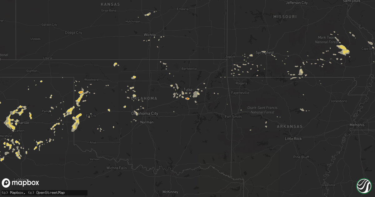
Hail Map on July 20, 2015
Get this storm
July 20 map
$229
one time, instant access
Download today. No call, no setup
Keep the $229
Bought the map and want the full workflow? Apply the entire $229 to a subscription within 7 days. None of it is wasted.
Every map, not just this one
This buys you this map. Subscription and you get every map we run, in the markets you choose from a few cities to whole states to nationwide. Plus real-time alerts the moment a storm fires.
Contact data
Name, contact info, occupancy, even credit band for addresses in the footprint. You go from where it hit to who to call.
Become the source they trust
Unlimited branding weather history reports on demand. You already have the documented answer ready for the property owner, and you are the one who showed up with it.
Property data and RoofTrace estimates
Pull up any address you have got, its value and the exact code rules for that jurisdiction, straight from One Click Code. Then RoofTrace estimates the squares, pitch, and roof value, priced the way you price.
States Impacted by Hail Map on July 20, 2015
Storm reports
New York
| Date | Description |
|---|---|
| 07/20/20153:50 PM CDT | Large tree and branches down at bethpage-sweethollow road |
Arkansas
| Date | Description |
|---|---|
| 07/19/20159:30 PM CDT | Measured wind gust of 58 mph from handheld anemometer near intersection of cr 611 and 623. |
| 07/19/20158:25 PM CDT | Powerlines down in salem. |
New Mexico
| Date | Description |
|---|---|
| 07/20/20156:45 PM CDT | A bnsf train partially derailed in strong winds near fort sumner. Several large rail cars were blown off the tracks. |
California
| Date | Description |
|---|---|
| 07/20/20156:05 PM CDT | Bear valley. |
| 07/20/20155:50 PM CDT | Golf ball size hail at hells kitchen vista. |
| 07/20/20155:50 PM CDT | 1 mile sw of bear valley at hells kitchen |
Michigan
| Date | Description |
|---|---|
| 07/19/20158:34 PM CDT | Several trees knocked down and one home damaged from a falling tree along the 7600 block of houghton lake road. Damage path of 230 yards with a maximum width of 75-100 |
Missouri
| Date | Description |
|---|---|
| 07/20/20156:16 PM CDT | Emergency management reported a tree down on highway dd se of kimberling city. Time estimated by radar. |
| 07/20/20155:53 PM CDT | Missouri highway patrol reported a tree down near cape fair. Time estimated by radar. |
| 07/19/20158:55 PM CDT | Power lines down on maud street near kanell blvd...and also at business 67 and vine street. |
| 07/19/20158:55 PM CDT | Small tree limbs broken and debris from trees scattered across area |
| 07/19/20157:40 PM CDT | Law enforcement reported a tree down near thomasville. Time estimated by radar. |
| 07/19/20157:20 PM CDT | Tree down. Bb hwy. |
Florida
| Date | Description |
|---|---|
| 07/20/20151:35 PM CDT | Broadcast media relayed a report of a tree down on a power line in high springs. |
North Carolina
| Date | Description |
|---|---|
| 07/20/20156:08 PM CDT | A report of trees and power lines down along river hill road. Time is estimated based on when the radar max velocity of 26 knots passed over that location. |
| 07/20/20154:40 PM CDT | Several trees down near granada golf course to the east of highway 321 near falls avenue. |
| 07/19/20158:16 PM CDT | Tree down across power lines on carol ave in locust |
| 07/19/20158:12 PM CDT | Trees down at butler road and hazelwood drive near highway 74 in forest city. |
| 07/19/20157:03 PM CDT | A tree in the roadway. |
| 07/19/20157:02 PM CDT | Tree in roadway on hambright road to the southwest of huntersville. A tree down on power lines at intersection of north main and fourth street. Time based on radar velo |
Connecticut
| Date | Description |
|---|---|
| 07/20/20152:25 PM CDT | Trees and wires down at intersection of tyler terrace and roode road |
| 07/20/20152:20 PM CDT | Trees and wires down on pinecrest lane |
| 07/20/20152:20 PM CDT | Trees and wires down at 5 lincoln square |
| 07/20/20152:20 PM CDT | Tree down at intersection of north burnham highway rt 169 and lisbon heights |
| 07/20/20152:04 PM CDT | Multiple trees and wires down on babock hill road |
| 07/20/20152:00 PM CDT | Multiple trees and wires down on babock hill road |
Kentucky
| Date | Description |
|---|---|
| 07/20/20153:35 AM CDT | Trees were blown down near sidney. |
| 07/20/20153:35 AM CDT | Trees were blown down near canada. |
| 07/19/201511:18 PM CDT | Large tree down causing damage to a deck. |
| 07/19/201511:15 PM CDT | A few trees down in and around morgantown. |
| 07/19/201511:05 PM CDT | Trees down. |
| 07/19/201511:05 PM CDT | Trees down blocking road. |
| 07/19/201511:00 PM CDT | Late report. Donwed trees and powerlines in the community with spotty power outages. |
| 07/19/20159:37 PM CDT | Dozens of tree limbs and several trees were blown down.the roof of a shed was blown off and two windows were blown out of a store front. |
| 07/19/20159:23 PM CDT | Tree and multiple limbs/branches down on new bethel road. |
| 07/19/20158:56 PM CDT | Trees down along highway 60. |
New Hampshire
| Date | Description |
|---|---|
| 07/20/20159:50 AM CDT | Spotter reported trees uprooted and snapped. |
Tennessee
| Date | Description |
|---|---|
| 07/20/20154:40 PM CDT | Several trees downed across northern part of blount county. |
| 07/20/20152:00 PM CDT | Power line reportedly blown down |
Oklahoma
| Date | Description |
|---|---|
| 07/20/20155:45 PM CDT | Carport pulled down. Time estimated from radar. |
| 07/20/20155:25 PM CDT | Power lines downed by strong winds. |
| 07/20/20155:25 PM CDT | Three power poles down. Time estimated from radar. |
| 07/20/20155:15 PM CDT | Large trees down especially near the junction of highways 64 and 62. |
| 07/20/20155:08 PM CDT | Report via social media pictures of hail. |
| 07/20/20154:40 PM CDT | Trees down near the armed forces reserve center. |
| 07/20/20154:25 PM CDT | Tree damage at 288th and 71st. |
| 07/20/20154:20 PM CDT | Power poles downed by strong winds. |
| 07/20/20154:00 PM CDT | Time estimated from radar. |
| 07/19/20159:20 PM CDT | A local report indicates 1.00 inch wind near YUKON |
Georgia
| Date | Description |
|---|---|
| 07/20/20156:18 PM CDT | Police blocking traffic at n carroll street and east 1st ave due to power line down |
| 07/20/20156:15 PM CDT | Several trees and power lines down around town |
| 07/20/20156:12 PM CDT | Downed tree on a power line eventually caught fire on the 400 block of w lincoln avenue in albany. Per wfxl meteorologist. |
| 07/20/20156:12 PM CDT | Wires down on the 700 block of north jackson street in albany...per wfxl meteorologist. |
| 07/20/20156:10 PM CDT | Tree snapped on cascade lane. Photo submitted on social media. |
| 07/20/20156:08 PM CDT | Photo of quarter size hail submitted on social media |
| 07/20/20156:03 PM CDT | Main power line down on murray hill lane in albany. Per wfxl meteorologist. |
| 07/20/20155:58 PM CDT | Tree down on westover road near westgate |
| 07/20/20154:37 PM CDT | Tree down near the intersection of perry dr and lake dr. Time estimated based on radar. |
| 07/19/20157:10 PM CDT | Wrdw-tv relayed social media report from the public of a tree down on a home in national hills. |
South Carolina
| Date | Description |
|---|---|
| 07/19/20158:55 PM CDT | Schp reports trees down on hwy 70 at the edisto river. |
| 07/19/20158:55 PM CDT | Schp reports trees down on cordova rd and wesley grove rd. |
| 07/19/20158:50 PM CDT | Schp reports trees down on us hwy 78 and mt. Zion rd... Between blackville and denmark. |
| 07/19/20158:15 PM CDT | Schp reports trees down at williston way and deering rd. |
| 07/19/20157:50 PM CDT | Aiken 911 reported tree down... Taking down a power line... Causing a small brush fire. |
| 07/19/20157:40 PM CDT | Pickesn sheriff office reports many trees and a few power lines down in the dacusville and easley areas. |
| 07/19/20157:40 PM CDT | Multiple trees down and a shed blown over... Foster blackmon dr and fork hill rd. |
Alabama
| Date | Description |
|---|---|
| 07/20/20154:47 PM CDT | Tree down on cedar springs road |
Kansas
| Date | Description |
|---|---|
| 07/19/20158:20 PM CDT | A local report indicates 1.00 inch wind near 2 NW GOESSEL |
Cities Impacted by Hail Map on July 20, 2015
- Geary, OK
- Calumet, OK
- Sudan, TX
- Nara Visa, NM
- Amarillo, TX
- Lovington, NM
- Nazareth, TX
- Dimmitt, TX
- Hart, TX
- Hedley, TX
- Lelia Lake, TX
- Sand Springs, OK
- Sapulpa, OK
- Clines Corners, NM
- Tulsa, OK
- Hobart, OK
- Fordland, MO
- Plainview, TX
- Olton, TX
- Kress, TX
- Mosquero, NM
- Tucumcari, NM
- Charleston, MO
- Vega, TX
- Dover, OK
- Hennessey, OK
- Gruver, TX
- Spearman, TX
- Hulbert, OK
- Mcalister, NM
- Great Falls, SC
- Yukon, OK
- Logan, NM
- Saint Cloud, FL
- Kenansville, FL
- Elida, NM
- Conchas Dam, NM
- Erick, OK
- Sayre, OK
- Cheyenne, OK
- Sweetwater, OK
- Wellington, TX
- Hollis, OK
- Mount Vernon, MO
- Mclean, TX
- Capitan, NM
- Clearwater, KS
- Wheeler, TX
- Cleveland, OK
- Chouteau, OK
- Ellsinore, MO
- Poplar Bluff, MO
- Elk City, OK
- Panhandle, TX
- Covelo, CA
- Carnegie, OK
- Briscoe, TX
- McClure, IL
- Cape Girardeau, MO
- Gage, OK
- Mobeetie, TX
- Alva, OK
- Lone Wolf, OK
- Moody, MO
- Caulfield, MO
- Pottersville, MO
- West Plains, MO
- Rogers, NM
- Causey, NM
- Farmington, MO
- Sainte Genevieve, MO
- Kiefer, OK
- Glenpool, OK
- Silva, MO
- Lodi, MO
- Patterson, MO
- Rogersville, AL
- Shattuck, OK
- Ringgold, GA
- Tunnel Hill, GA
- Hohenwald, TN
- Dora, MO
- Cape Fair, MO
- Coarsegold, CA
- Oakhurst, CA
- Masterson, TX
- Channing, TX
- Miami, TX
- Montague, CA
- Yreka, CA
- North Fork, CA
- O'Neals, CA
- Newkirk, OK
- Crandall, GA
- Sharon, OK
- Silverton, TX
- Canadian, TX
- Stilwell, OK
- Metropolis, IL
- Leedey, OK
- Hammon, OK
- Wildorado, TX
- Happy, TX
- Cochran, GA
- Stotts City, MO
- Sarcoxie, MO
- Crawford, OK
- Arnett, OK
- Durham, OK
- Udall, KS
- Cashion, OK
- Kingfisher, OK
- Baltic, CT
- North Franklin, CT
- Noel, MO
- Lanagan, MO
- Floral, AR
- Kellyville, OK
- Jesup, GA
- Hurricane Mills, TN
- Shell Knob, MO
- Clovis, NM
- Hilger, MT
- Lawrenceburg, TN
- Birch Tree, MO
- Mounds, OK
- Bixby, OK
- Sturgis, KY
- Clubb, MO
- Bay Minette, AL
- Maryville, TN
- Friendsville, TN
- Lenoir City, TN
- Greenback, TN
- Lobelville, TN
- Donaldsonville, LA
- Belleview, MO
- Grady, NM
- Piedmont, MO
- Ellington, MO
- Arnold, CA
- Colchester, CT
- Tahlequah, OK
- Canyon, TX
- San Jon, NM
- Tulia, TX
- Waverly, TN
- Neosho, MO
- Goodman, MO
- Newton, KS
- Hillsboro, KS
- Goessel, KS
- Canton, KS
- Moundridge, KS
- Waynesboro, MS
- Cairo, IL
- Hereford, TX
- Burlington, OK
- Hattieville, AR
- Greenville, MO
- Des Arc, MO
- Annapolis, MO
- Fredericktown, MO
- Pineville, MO
- Anderson, MO
- Farwell, TX
- Gainesville, MO
- Franklin, LA
- Edmond, OK
- Oklahoma City, OK
- Tuttle, OK
- Bison, OK
- Thibodaux, LA
- Monett, MO
- Pierce City, MO
- Vici, OK
- Camargo, OK
- Patton, MO
- Cassville, MO
- Long Barn, CA
- Denmark, SC
- Big Sandy, MT
- Muleshoe, TX
- Portales, NM
- Washburn, MO
- Exeter, MO
- Cherokee, OK
- Coweta, OK
- Enochs, TX
- Galena, MO
- Reydon, OK
- Broken Arrow, OK
- Golconda, IL
- Gamaliel, AR
- Clarkridge, AR
- Mountain Home, AR
- Lakeview, TX
- Mulberry, AR
- Alma, AR
- Haskell, OK
- Bowling Green, KY
- Morgantown, KY
- Weatherford, OK
- Hazlehurst, GA
- Denton, GA
- Pampa, TX
- Drumright, OK
- Mannford, OK
- Bristow, OK
- Gulfport, MS
- Mill Spring, MO
- Hardy, AR
- El Reno, OK
- Mustang, OK
- Pep, NM
- Clarendon, TX
- Kremlin, OK
- Enid, OK
- Bass Lake, CA
- Wishon, CA
- Morganfield, KY
- Burbank, OK
- Verona, MO
- Crane, MO
- Aurora, MO
- Jay, OK
- Ames, OK
- Drummond, OK
- Richton, MS
- White, GA
- Cartersville, GA
- Marion, KS
- Ocean City, MD
- Waukomis, OK
- Bertrand, MO
- Willard, NM
- Winona, MO
- Selbyville, DE
- Fenwick Island, DE
- Bishopville, MD
- Centerville, TN
- Purdy, MO
- Columbia, TN
- Osage, OK
- Pomona, MO
- Terlton, OK
- Melbourne, AR
- Only, TN
- Nunnelly, TN
- Douglass, KS
- Adrian, TX
- Shidler, OK
- Pocasset, OK
- Jerusalem, AR
- Plattenville, LA
- Belle Rose, LA
- Viola, AR
- Gepp, AR
- Shawneetown, IL
- Acworth, GA
- Kennesaw, GA
- Kaw City, OK
- Rogersville, MO
- Blackville, SC
- Cypress, IL
- Belknap, IL
- Vienna, IL
- Lumber City, GA
- Springfield, SC
- Rocky Comfort, MO
- Stella, MO
- Hayes, VA
- Udall, MO
- Tecumseh, MO
- Earth, TX
- Tumbling Shoals, AR
- Drasco, AR
- Ida, AR
- Inola, OK
- Pryor, OK
- Claremore, OK
- Aiken, SC
- New Ellenton, SC
- Beech Island, SC
- Ava, MO
- Mountain View, MO
- Squires, MO
- Boley, OK
- Perryville, MO
- Danville, AR
- Belgrade, MO
- Caledonia, MO
- Hartville, MO
- Hale Center, TX
- Marietta, GA
- Jackson, MO
- Heath Springs, SC
- Lancaster, SC
- Lexington, AL
- Killen, AL
- Loxley, AL
- Albany, GA
- Sacramento, KY
- Bremen, KY
- Quail, TX
- Denton, MT
- Dardanelle, AR
- Guthrie, OK
- Augusta, KS
- Lloyd, MT
- Norwood, MO
- Macomb, MO
- Schriever, LA
- Grantsburg, IL
- Hampshire, TN
- Summertown, TN
- Willow Springs, MO
- Chester, OK
- Fairview, OK
- Branson, MO
- Reeds Spring, MO
- Atlanta, GA
- Granby, MO
- Fairview, MO
- Alton, MO
- Culleoka, TN
- Brownsville, KY
- Roundhill, KY
- Hawesville, KY
- Lewisport, KY
- Dalton, GA
- Vulcan, MO
- Lesterville, MO
- Ironton, MO
- Springlake, TX
- Smithville, GA
- Leesburg, GA
- Catoosa, OK
- Haysville, KS
- Rose Hill, KS
- Derby, KS
- Wichita, KS
- Shamrock, TX
- Cohutta, GA
- Neeses, SC
- Arcadia, MO
- Carrier, OK
- Texola, OK
- Soda Springs, CA
- Jonesville, VA
- Benton, KY
- Kevil, KY
- Grand Chain, IL
- Springfield, MO