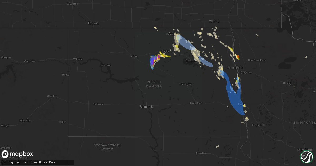
Hail Map in North Dakota on July 19, 2021
Get this storm
July 19 map
$229
one time, instant access
Download today. No call, no setup
Keep the $229
Bought the map and want the full workflow? Apply the entire $229 to a subscription within 7 days. None of it is wasted.
Every map, not just this one
This buys you this map. Subscription and you get every map we run, in the markets you choose from a few cities to whole states to nationwide. Plus real-time alerts the moment a storm fires.
Contact data
Name, contact info, occupancy, even credit band for addresses in the footprint. You go from where it hit to who to call.
Become the source they trust
Unlimited branding weather history reports on demand. You already have the documented answer ready for the property owner, and you are the one who showed up with it.
Property data and RoofTrace estimates
Pull up any address you have got, its value and the exact code rules for that jurisdiction, straight from One Click Code. Then RoofTrace estimates the squares, pitch, and roof value, priced the way you price.
Storm reports in North Dakota
North Dakota
| Date | Description |
|---|---|
| 07/19/20216:51 PM CDT | Time estimated based on radar. |
| 07/19/20216:49 PM CDT | Peak wind measured at an ndawn station at 10 meters. |
| 07/19/20216:35 PM CDT | A local report indicates 1.50 inch wind near 5 NW GEORGE LAKE |
| 07/19/20216:35 PM CDT | A local report indicates 70 MPH wind near 5 NW GEORGE LAKE |
| 07/19/20216:30 PM CDT | Relayed by broadcast media partner. Most hail was smaller... But were a few golf balls. |
| 07/19/20216:30 PM CDT | Cottonwood trees blown over. Same individual reported the ground was white with hail 4 miles east of karlsruhe... And all his hay there was blown way. Report was relaye |
| 07/19/20216:30 PM CDT | 70 mph wind gusts and ping pong ball size hail caused a variety of damage. Window screens were shredded... Some windows were broken... Siding was damaged on house and c |
| 07/19/20216:22 PM CDT | A local report indicates 60 MPH wind near 4 NNW GEORGE LAKE |
| 07/19/20215:45 PM CDT | Relayed by broadcast media. Time estimated from radar. |
| 07/19/20212:34 PM CDT | Report from mping: 1-inch tree limbs broken; shingles blown off. |
| 07/19/20212:30 PM CDT | Measured at hector international airport. |
| 07/19/20212:29 PM CDT | Measured at hector international airport /kfar/. |
| 07/19/20212:29 PM CDT | Peak wind measured at a personal weather station. |
| 07/19/20212:06 PM CDT | Power knocked out... Medium to large tree branches felled... Roof vent blown off. Via social media. |
| 07/19/20212:05 PM CDT | . |
| 07/19/20212:05 PM CDT | Large trees down... One tree damaged part of house. |
| 07/19/20211:45 PM CDT | Nws employee estimate of 50 to 60 mph just south of hillsboro ahead of main line of storms. |
| 07/19/20211:43 PM CDT | A few large 4 to 6 inch branches broken down. Power out for a short period. |
| 07/19/20211:38 PM CDT | Power knocked out... Medium to large tree branches felled... Roof vent blown off. Via social media. |
| 07/19/20211:38 PM CDT | A local report indicates 1.00 inch wind near 6 E BUXTON |
| 07/19/20211:35 PM CDT | Several large hadrwood and evergreen trees snapped. Widespread power outages. Time estimated based on radar and nearby wind sensor reports. |
| 07/19/20211:18 PM CDT | Estimated 60 to 70 mph in hatton. |
| 07/19/20211:18 PM CDT | Estimated 60 to 70 mph wind gust. |
| 07/19/20211:05 PM CDT | Estimated 60 to 70 mph wind gust. |
| 07/19/202112:05 PM CDT | A few large 3 to 5 inch diameter branches broken down in town. |
| 07/19/202111:45 AM CDT | Via social media. |
| 07/19/20217:11 AM CDT | At 1210 PM CDT, a severe thunderstorm was located near Michigan, or 34 miles east of Devils Lake, moving southeast at 35 mph. HAZARD...60 mph wind gusts and nickel size hail. SOURCE...Radar indicated. IMPACT...Expect damage to roofs, siding, and trees. This severe thunderstorm will be near... Petersburg around 1215 PM CDT.Other locations in the path of this severe thunderstorm include LoganCenter and Northwood. |
| 07/19/20216:28 AM CDT | At 1128 AM CDT, a severe thunderstorm was located 7 miles east of Webster, or 13 miles northeast of Devils Lake, moving southeast at 35 mph. HAZARD...60 mph wind gusts and quarter size hail. SOURCE...Radar indicated. IMPACT...Hail damage to vehicles is expected. Expect wind damage to roofs, siding, and trees. This severe thunderstorm will be near... Southam and Crary around 1145 AM CDT.Other locations in the path of this severe thunderstorm includeDoyon, Bartlett, Lakota and Mapes. |
| 07/19/20212:19 AM CDT | At 718 PM CDT, a severe thunderstorm was located 6 miles west of Drake, or 27 miles west of Harvey, moving south at 15 mph. This is a very dangerous storm. HAZARD...Baseball size hail and 70 mph wind gusts. SOURCE...Radar indicated. IMPACT...People and animals outdoors will be severely injured. Expect shattered windows, extensive damage to roofs, siding, and vehicles. Locations impacted include... Drake, Anamoose, Butte, Balfour, Kief, Sheyenne Lake and Krueger Lake. |
| 07/19/20211:44 AM CDT | At 643 PM CDT, a severe thunderstorm was located over Perth, or 51 miles west of Langdon, moving southeast at 45 mph. HAZARD...Ping pong ball size hail and 60 mph wind gusts. SOURCE...Radar indicated. IMPACT...People and animals outdoors will be injured. Expect hail damage to roofs, siding, windows, and vehicles. Expect wind damage to roofs, siding, and trees. This severe thunderstorm will be near... Perth around 645 PM CDT. Bisbee around 655 PM CDT. Cando around 715 PM CDT.Other locations in the path of this severe thunderstorm includeConsidine and Cando. |
| 07/19/20211:44 AM CDT | At 643 PM CDT, a severe thunderstorm was located 7 miles west of Bisbee, or 14 miles south of Rolla, moving southeast at 35 mph. HAZARD...60 mph wind gusts and quarter size hail. SOURCE...Radar indicated. IMPACT...Hail damage to vehicles is expected. Expect wind damage to roofs, siding, and trees. Locations impacted include... Mylo and Agate. |
| 07/19/20211:26 AM CDT | At 625 PM CDT, a severe thunderstorm was located 8 miles southeast of Karlsruhe, or 30 miles northwest of Harvey, moving south at 15 mph. HAZARD...Two inch hail and 60 mph wind gusts. SOURCE...Public. IMPACT...People and animals outdoors will be injured. Expect hail damage to roofs, siding, windows, and vehicles. Expect wind damage to roofs, siding, and trees. This severe thunderstorm will be near... Drake around 655 PM CDT.Other locations impacted by this severe thunderstorm include Balfour,George Lake, Kief and Bergen. |
| 07/19/202112:28 AM CDT | At 528 PM CDT, a severe thunderstorm was located 9 miles northwest of Balta, or 13 miles southwest of Rugby, moving southeast at 10 mph. HAZARD...Golf ball size hail and 60 mph wind gusts. SOURCE...Radar indicated. IMPACT...People and animals outdoors will be injured. Expect hail damage to roofs, siding, windows, and vehicles. Expect wind damage to roofs, siding, and trees. Locations impacted include... Rugby, Towner, Balta, Berwick, Silva, Orrin and George Lake. |
| 07/18/20217:20 PM CDT | Combined with pea size hail. |
| 07/18/20217:15 PM CDT | Public report of thunderstorm wind gusts around 60-65 mph along with hail not quite golf ball size. Garden is ruined. |
| 07/18/20217:15 PM CDT | Public report of hail not quite golf ball size... Along with 60-65 mph winds. Garden is ruined. |
| 07/18/20217:10 PM CDT | Drifts of dime size hail but a few quarters were noted. Was combined with 60 mph wind gusts. Garden was flattened. |
| 07/18/20217:10 PM CDT | Corrects previous hail report from 1 s balfour. Drifts of dime size hail but a few quarters were noted. Was combined with 60 mph wind gusts. Garden was flattened. |
| 07/18/20217:07 PM CDT | Most of the hail was small mixed with some golf ball size and a few baseball size hailstones. Relayed to nws by broadcast media partner. |
All States Impacted by Hail Map on July 19, 2021
Cities Impacted by Hail Map on July 19, 2021
- Perth, ND
- Rugby, ND
- Karlsruhe, ND
- Crystal, ND
- Boonville, NY
- Milroy, PA
- Woodbine, GA
- Inkster, ND
- Balfour, ND
- Towner, ND
- Franklinton, LA
- Cavalier, ND
- Wahpeton, ND
- Petersburg, ND
- Fordville, ND
- Michigan, ND
- Gillett, PA
- Columbia Cross Roads, PA
- San Marcos, TX
- Bottineau, ND
- Spring Mills, PA
- Loganton, PA
- Mill Hall, PA
- Longville, LA
- Ragley, LA
- Devils Lake, ND
- Crary, ND
- Mylo, ND
- Adams, ND
- San Antonio, TX
- Egeland, ND
- Cass Lake, MN
- Wales, ND
- Williams, AZ
- Larimore, ND
- Hillsboro, ND
- Blanchard, ND
- Galesburg, ND
- Hunter, ND
- East Grand Forks, MN
- Oslo, MN
- Alvarado, MN
- Hannah, ND
- Amado, AZ
- Langdon, ND
- Buxton, ND
- Cummings, ND
- Caledonia, ND
- Coburn, PA
- Call, TX
- Kirbyville, TX
- Webster, ND
- Niagara, ND
- Florence, TX
- Grafton, ND
- Fonda, NY
- Johnstown, NY
- Munich, ND
- Starkweather, ND
- Dahlen, ND
- Northwood, ND
- Wolford, ND
- Wolverton, MN
- Drayton, ND
- Minto, ND
- Manvel, ND
- Edmore, ND
- Agate, ND
- Rolla, ND
- Rocklake, ND
- Leeds, ND
- Bisbee, ND
- Cando, ND
- York, ND
- Reynolds, ND
- Drake, ND
- Hensel, ND
- Walhalla, ND
- Lankin, ND
- Belcourt, ND
- Saint John, ND
- Tolna, ND
- Park River, ND
- Millheim, PA
- Pekin, ND
- Brocket, ND
- Lawton, ND
- Moorhead, MN
- Argyle, MN
- Fairdale, ND
- Alsen, ND
- Knox, ND
- Sharon, ND
- Aneta, ND
- Langford, SD
- Britton, SD
- Portland, ND
- Kent, MN
- Forest River, ND
- Lock Haven, PA
- Big Falls, MN
- Lewisburg, PA
- Liverpool, PA
- Dalmatia, PA
- Port Trevorton, PA
- Lakota, ND
- Glyndon, MN
- Sabin, MN
- Hatton, ND
- New Braunfels, TX
- Crane Lake, MN
- Allenwood, PA
- Richfield, PA
- Mount Pleasant Mills, PA
- La Porte, TX
- Houston, TX
- Baytown, TX
- Deer Park, TX
- Lampasas, TX
- Leander, TX
- Barnesville, MN
- Finley, ND
- Grandin, ND
- Badger, MN
- Greenbush, MN
- Morris, PA
- Wheatland, ND
- Georgetown, TX
- Liberty Hill, TX
- Channelview, TX
- Edinburg, ND
- Reedsville, PA
- Arvilla, ND
- Saint Augustine, FL
- Orr, MN
- McAlisterville, PA
- Schertz, TX
- Harwood, ND
- Christine, ND
- Fargo, ND
- Casselton, ND
- Argusville, ND
- Horace, ND
- Comstock, MN
- Walcott, ND
- Halstad, MN
- Amenia, ND
- Gardner, ND
- Mapleton, ND
- Mayville, ND
- Arthur, ND
- Davenport, ND
- Shelly, MN
- Erie, ND
- Kindred, ND
- Hendrum, MN
- West Fargo, ND
- Clifford, ND
- Voltaire, ND
- Butte, ND
- Warren, MN


