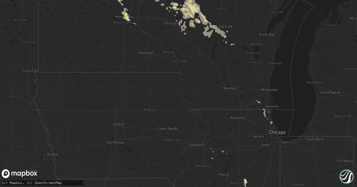
Hail Map in Wisconsin on July 19, 2011
Get this storm
July 19 map
$229
one time, instant access
Download today. No call, no setup
Keep the $229
Bought the map and want the full workflow? Apply the entire $229 to a subscription within 7 days. None of it is wasted.
Every map, not just this one
This buys you this map. Subscription and you get every map we run, in the markets you choose from a few cities to whole states to nationwide. Plus real-time alerts the moment a storm fires.
Contact data
Name, contact info, occupancy, even credit band for addresses in the footprint. You go from where it hit to who to call.
Become the source they trust
Unlimited branding weather history reports on demand. You already have the documented answer ready for the property owner, and you are the one who showed up with it.
Property data and RoofTrace estimates
Pull up any address you have got, its value and the exact code rules for that jurisdiction, straight from One Click Code. Then RoofTrace estimates the squares, pitch, and roof value, priced the way you price.
Storm reports in Wisconsin
Wisconsin
| Date | Description |
|---|---|
| 07/19/20116:28 PM CDT | A few power lines and trees down along highway 8 in town. |
| 07/19/20116:15 PM CDT | A few trees and powerlines down along 600 block of peterson. |
| 07/19/20116:10 PM CDT | A local report indicates 1.75 inch wind near BIRCHWOOD |
| 07/19/20116:10 PM CDT | Several brances down. 8 inch poplar branch snapped. At 800 pm...power was still out in winter. |
| 07/19/20116:10 PM CDT | A local report indicates 2.50 inch wind near 6 E BIRCHWOOD |
| 07/19/20116:00 PM CDT | A local report indicates 2.00 inch wind near 5 NW STONE LAKE |
| 07/19/20116:00 PM CDT | Many 16 inch diameter maples snapped off. Large oak topped and large oak uprooted. |
| 07/19/20115:57 PM CDT | A local report indicates 1.25 inch wind near 3 S STONE LAKE |
| 07/19/20115:50 PM CDT | A local report indicates 1.75 inch wind near COUDERAY |
| 07/19/20115:40 PM CDT | A local report indicates 2.50 inch wind near EDGEWATER |
| 07/19/20115:40 PM CDT | Estimated wind speed of 50 to 60 mph. |
| 07/19/20115:40 PM CDT | Power out in the town of hayward. |
| 07/19/20115:15 PM CDT | Large tree down on smith bridge road. |
| 07/19/20115:10 PM CDT | Six 12 inch diameter trees down blocking highway 35. |
| 07/19/20115:10 PM CDT | Measured wind speed 59 mph. Torential rainfall obscuring visibility. Trees down along highway 53. |
| 07/19/20114:55 PM CDT | Tree uprooted at wayside rest. |
| 07/19/20114:52 PM CDT | Small tree branches blowing across highway 35. Dime size hail. |
| 07/19/201112:45 AM CDT | 2 inch branches down |
| 07/19/201112:22 AM CDT | Large tree branch blown down...blocking several lanes of traffic. |
| 07/19/201112:18 AM CDT | Large tree branch down on road near cty rd yy and hwy 49 intersection |
| 07/19/201112:00 AM CDT | Scattered power outages across green lake county due to winds breaking tree branches which then impacted power lines. City of berlin is without power. Other locations w |
| 07/18/201111:44 PM CDT | Tree damage with estimated wind gusts to around 60 mph. |
| 07/18/201111:25 PM CDT | Large branches fell and tents were damaged to approx 250 scouts at camp freeland leslie on the adams and marquette county line in central wisconsin. |
| 07/18/201110:30 PM CDT | Penny size hail also reported. |
| 07/18/201110:20 PM CDT | A couple trees knocked down across the road just south of merrillan near garage rd. |
| 07/18/201110:15 PM CDT | 8 inch tree down. Time estimated. 1.22 inches of rain fell in 20 minutes as well. |
| 07/18/201110:15 PM CDT | Estimated between 60 and 70 mph. 12 inch diameter branch down. |
| 07/18/201110:10 PM CDT | A number of trees knocked down near northfield. One was north of hwy 121 along county road g. Another along degroot rd east of northfield off of hwy 121. |
| 07/18/20119:56 PM CDT | A local report indicates 60 MPH wind near 2 E LOYAL |
| 07/18/20119:52 PM CDT | Trees down. |
| 07/18/20119:50 PM CDT | Tree down. |
| 07/18/20119:40 PM CDT | A local report indicates 60 MPH wind near CHRISTIE |
| 07/18/20119:38 PM CDT | A local report indicates 60 MPH wind near 1 N VEEFKIND |
| 07/18/20119:30 PM CDT | Trees down on power line. |
| 07/18/20119:12 PM CDT | Tree down at intersection of hwy 73 and hickory. |
| 07/18/20119:05 PM CDT | Trees down across highway 178. |
| 07/18/20118:55 PM CDT | Trees down across road. |
| 07/18/20118:55 PM CDT | A local report indicates 60 MPH wind near THORP |
| 07/18/20118:40 PM CDT | Tree down across road. |
| 07/18/20118:40 PM CDT | Tree down across road. |
| 07/18/20118:40 PM CDT | Tree down across road. |
| 07/18/20118:33 PM CDT | A local report indicates 60 MPH wind near 1 NE VEEFKIND |
| 07/18/20118:30 PM CDT | Tree down across road. |
| 07/18/20118:30 PM CDT | Tree down across road. |
| 07/18/20118:25 PM CDT | Few trees down across roads. |
| 07/18/20118:15 PM CDT | 18 inch diameter tree snapped. Delayed report...time estimated. |
| 07/18/20118:15 PM CDT | A local report indicates 1.00 inch wind near COMSTOCK |
| 07/18/20118:14 PM CDT | A local report indicates 61 MPH wind near 3 NE LUBLIN |
| 07/18/20117:56 PM CDT | Large branches down. Strong wind lasted for 10-15 minutes. |
| 07/18/20117:52 PM CDT | Tree damage |
| 07/18/20117:45 PM CDT | Tree down over road. |
| 07/18/20117:40 PM CDT | Trees down. Boats lifted. Docks destroyed. Numerous buildings damaged near pipe lake. Damage also reported around johnstown township. Time estimated based on radar. Dam |
| 07/18/20117:30 PM CDT | Tree down along polley road west of hwy 73. |
| 07/18/20117:25 PM CDT | A local report indicates 60 MPH wind near 2 W GILMAN |
| 07/18/20117:22 PM CDT | 40 foot tree down. Power lost across town. |
All States Impacted by Hail Map on July 19, 2011
Cities Impacted by Hail Map on July 19, 2011
- Voltaire, ND
- Velva, ND
- Ruso, ND
- Clementon, NJ
- Blackwood, NJ
- Georgetown, IN
- New Braunfels, TX
- Bainbridge, OH
- Bushnell, NE
- Hoople, ND
- Crystal, ND
- Whaleyville, MD
- Snow Hill, MD
- Ocean City, MD
- Showell, MD
- Newark, MD
- Selbyville, DE
- Willards, MD
- Bishopville, MD
- Pittsville, MD
- Fenwick Island, DE
- Berlin, MD
- Chaptico, MD
- Coltons Point, MD
- Cobb Island, MD
- Bushwood, MD
- Newburg, MD
- Issue, MD
- Big Sandy, MT
- Gildford, MT
- Carter, MT
- Fort Benton, MT
- Millville, NJ
- Bridgeton, NJ
- Beattyville, KY
- Lawton, ND
- Bloomer, WI
- New Auburn, WI
- Cornell, WI
- Cooksville, IL
- Ellsworth, IL
- Towanda, IL
- Normal, IL
- Springbrook, WI
- Butte, ND
- Barnum, MN
- Carlton, MN
- Bennington, IN
- Madison, IN
- Vevay, IN
- Lawrenceburg, KY
- Frankfort, KY
- Saint Paul, MN
- Minneapolis, MN
- Moscow, OH
- Denver, CO
- Coxs Creek, KY
- Easton, MD
- Saint Michaels, MD
- Milaca, MN
- Princeton, MN
- Bloomfield, KY
- Taylorsville, KY
- Danville, KY
- Parksville, KY
- Perryville, KY
- Saint Ignatius, MT
- Rhame, ND
- Sentinel Butte, ND
- Medora, ND
- Westport, PA
- Havre, MT
- Holcombe, WI
- Cockeysville, MD
- Sparks Glencoe, MD
- Spicewood, TX
- Austin, TX
- Dripping Springs, TX
- Bloomington, IL
- Downs, IL
- Annapolis, MD
- Arnold, MD
- Exeland, WI
- Hayward, WI
- Birchwood, WI
- Spooner, WI
- Bruce, WI
- Trego, WI
- Stone Lake, WI
- Loma, MT
- Solomons, MD
- Lusby, MD
- California, MD
- Lexington Park, MD
- Hollywood, MD
- Saint Leonard, MD
- Kersey, CO
- Vanceburg, KY
- Max, ND
- Adams, ND
- Stanton, KY
- Boyd, WI
- Stanley, WI
- Clarence, PA
- Bellefonte, PA
- Leeds, ND
- Churchs Ferry, ND
- Craig, CO
- Montoursville, PA
- Williamsport, PA
- Wellington, CO
- Starkweather, ND
- Webster, ND
- Elk City, ID
- Gilman, WI
- Lublin, WI
- Le Roy, IL
- Lewistown, MT
- Hughesville, PA
- Muncy Valley, PA
- Muncy, PA
- Unityville, PA
- Hillsgrove, PA
- Brighton, CO
- Rugby, ND
- Moose Lake, MN
- Abbotsford, WI
- Unity, WI
- Curtiss, WI
- Medford, WI
- Dorchester, WI
- Colby, WI
- Frankford, DE
- Ocean View, DE
- Dagsboro, DE
- Millville, DE
- Fairdale, ND
- Hingham, MT
- Moore, TX
- Pearsall, TX
- Lanse, MI
- Patuxent River, MD
- Broomes Island, MD
- Great Mills, MD
- Louisville, KY
- Karthaus, PA
- Cadott, WI
- Mill Hall, PA
- Vernal, UT
- Livermore, CO
- Mechanicsville, MD
- Clements, MD
- San Marcos, TX
- Comstock, WI
- Grand Marais, MN
- Edinburg, ND
- Saint Thomas, ND
- Hensel, ND
- Chippewa Falls, WI
- Warren, MN
- London, KY
- Verndale, MN
- Alzada, MT
- Hulett, WY
- Withee, WI
- Owen, WI
- Greenwood, WI
- Loyal, WI
- Cumberland, WI
- Frederic, WI
- Farmer City, IL
- Clearbrook, MN
- Brooksville, KY
- Bethel, OH
- New Richmond, OH
- Felicity, OH
- Georgetown, OH
- Foster, KY
- Karlsruhe, ND
- Towner, ND
- Cedarville, NJ
- Port Norris, NJ
- Fortescue, NJ
- Newport, NJ
- Saint Hilaire, MN
- Thief River Falls, MN
- Mosinee, WI
- Junction City, WI
- Milladore, WI
- Stratford, WI
- Auburndale, WI
- Chester, MT
- Webster, WI
- Siren, WI
- Grantsburg, WI
- Arpin, WI
- Nottingham, PA
- Rising Sun, MD
- Quarryville, PA
- Conowingo, MD
- Peach Bottom, PA
- Oxford, PA
- Colora, MD
- Kirkwood, PA
- Geraldine, MT
- Wilmington, OH
- Kremlin, MT
- Devils Lake, ND
- Esmond, ND
- Edmore, ND
- Cando, ND
- Lankin, ND
- York, ND
- Fordville, ND
- Hampden, ND
- Milton, ND
- Goodridge, MN
- Keenesburg, CO
- Hudson, CO
- Floodwood, MN
- Deer River, MN
- Chassell, MI
- Duchesne, UT
- Altamont, UT
- Park River, ND
- La Grange, KY
- Bedford, KY
- Westport, KY
- Pendleton, KY
- Sedalia, CO
- Golden, CO
- Black Hawk, CO
- Motley, MN
- Pillager, MN
- Cushing, MN
- Floweree, MT
- Douglas, ND
- Fairplay, MD
- Boonsboro, MD
- Keedysville, MD
- Hagerstown, MD
- Sharpsburg, MD
- Mandaree, ND
- Killdeer, ND
- Foxboro, WI
- Superior, WI
- Gordon, WI
- Danbury, WI
- Holyoke, MN
- Renovo, PA
- Grafton, ND
- Leonard, MN
- Peerless, MT
- Tabiona, UT
- Cromwell, MN
- Sawyer, MN
- Wright, MN
- Grand Rapids, MN
- Minto, ND
- Nederland, CO
- Plainfield, WI
- Bancroft, WI
- Puposky, MN
- Marshfield, WI
- Galva, IL
- Balfour, ND
- Winifred, MT
- Lloyd, MT
- Center, ND
- Cross Fork, PA
- Parkville, MD
- Orleans, IN
- Reisterstown, MD
- Inverness, MT
- Viking, MN
- Clayton, NJ
- Glassboro, NJ
- Washington Court House, OH
- Sabina, OH
- Lutsen, MN
- Toivola, MI
- Ontonagon, MI
- Joplin, MT
- Couderay, WI
- Sarona, WI
- Ladysmith, WI
- Wrenshall, MN
- Minong, WI
- Kerrick, MN
- Atkinson, IL
- Luck, WI
- Turtle Lake, WI
- Almena, WI
- Jackson, MN
- Alpha, MN
- Cohasset, MN
- Wisconsin Rapids, WI
- Frankfort, OH
- Clarksburg, OH
- Gully, MN
- Gonvick, MN
- Pease, MN
- Foreston, MN
- Ryder, ND
- Roseglen, ND
- Cogan Station, PA
- Paris, IL
- Shepherdstown, WV
- Harpers Ferry, WV
- Shenandoah Junction, WV
- Booneville, KY
- Ricetown, KY
- Evanston, WY
- Garrison, ND
- Rudyard, MT
- Roggen, CO
- Blue Creek, OH
- Otway, OH
- Stevens Point, WI
- Plover, WI
- Little Falls, MN
- Pierz, MN
- Clarksville, OH
- Roosevelt, UT
- Bluebell, UT
- Bemidji, MN
- New Holland, OH
- Commerce City, CO
- Deerfield, IL
- Glenview, IL
- Highland Park, IL
- Northbrook, IL
- Rocksprings, TX
- Paradise, PA
- Parkesburg, PA
- Atglen, PA
- Gap, PA
- Christiana, PA
- Kinzers, PA
- Cochranville, PA
- Backus, MN
- Pine River, MN
- Nevis, MN
- Weyerhaeuser, WI
- Sheldon, WI
- Glen Flora, WI
- Castle Rock, CO
- Colonial Beach, VA
- Loretto, VA
- Port Royal, VA
- King George, VA
- Bigfoot, TX
- Mendota, MN
- Circle Pines, MN
- South Saint Paul, MN
- Inver Grove Heights, MN
- Williamsburg, OH
- Batavia, OH
- East Bernstadt, KY
- Falmouth, KY
- Kelliher, MN
- Westfield, NC
- Oslo, MN
- East Grand Forks, MN
- Harbeson, DE
- Lewes, DE
- Howard, PA
- Orviston, PA
- Pelkie, MI
- Baraga, MI
- Isanti, MN
- Zimmerman, MN
- Saint Francis, MN
- Campton, KY
- Jackson, KY
- Campbellsburg, IN
- Mitchell, IN
- Bedford, IN
- Custer, WI
- Chetek, WI
- Bruno, MN
- Waukegan, IL
- Wadsworth, IL
- Charlotte, IA
- Goose Lake, IA
- Vincent, KY
- Talmage, UT
- Drake, ND
- East Earl, PA
- Narvon, PA
- Paris, KY
- Cynthiana, KY
- Carlisle, KY
- Girdletree, MD
- Thorp, WI
- Elk River, MN
- Benton, PA
- Callao, VA
- Kinsale, VA
- Littleton, CO
- Morrison, CO
- Pine, CO
- Conifer, CO
- Ojibwa, WI
- Radisson, WI
- Carr, CO
- Beech Creek, PA
- Willard, WI
- Balta, ND
- Cloquet, MN
- Mount Olivet, KY
- Dowell, MD
- Port Republic, MD
- Pisek, ND
- Elmer, NJ
- Monroeville, NJ
- Hague, VA
- Montross, VA
- Franklinville, NJ
- Newfield, NJ
- Malaga, NJ
- Orchard, CO
- Evergreen, CO
- Winter, WI
- Williamstown, NJ
- Sewell, NJ
- Mifflinburg, PA
- Brainerd, MN
- Baxter, MN
- Caret, VA
- Spencer, WI
- Conrath, WI
- Hawkins, WI
- Hillman, MN
- Foley, MN
- Wyanet, IL
- Tiskilwa, IL
- Buda, IL
- Fort Lupton, CO
- Mount Orab, OH
- Bonnieville, KY
- Danville, PA
- Bloomsburg, PA
- Bailey, CO
- Fort Ripley, MN
- Cascade, VA
- Plaza, ND
- Owings Mills, MD
- Glyndon, MD
- Chestertown, MD
- Hines, MN
- Tony, WI
- Augusta, WI
- Fairchild, WI
- Battletown, KY
- Cotulla, TX
- Leonardtown, MD
- Avenue, MD
- Jim Falls, WI
- Grygla, MN
- Fall Creek, WI
- Del Rio, TX
- Drayden, MD
- Tall Timbers, MD
- Valley Lee, MD
- Piney Point, MD
- Wild Rose, WI
- Waupaca, WI
- Almond, WI
- Union Star, KY
- Rhodelia, KY
- Milltown, WI
- Balsam Lake, WI
- Ripon, WI
- Green Lake, WI
- Greenville, IN
- Pekin, IN
- Salt Lick, KY
- Morehead, KY
- Kennan, WI
- Rudolph, WI
- Kewanee, IL
- South Salem, OH
- Greenfield, OH
- Antioch, IL
- Round Lake, IL
- Mundelein, IL
- Grayslake, IL
- Ingleside, IL
- Lake Villa, IL
- Funkstown, MD
- Pittsville, WI
- Roy, MT
- Preston, IA
- Prairie Farm, WI
- Barron, WI
- Dallas, WI
- Manvel, ND
- Tenstrike, MN
- Henderson, CO
- Max, MN
- Vernon Hills, IL
- Frenchburg, KY
- Crestwood, KY
- Buckner, KY
- Hewitt, MN
- Wadena, MN
- Woodbine, NJ
- Westminster, CO
- Arvada, CO
- Warsaw, VA
- Ely, MN
- La Grande, OR
- Sawyer, ND
- Hixton, WI
- Alma Center, WI
- Osseo, WI
- Burlington, WI
- Bozman, MD
- Royal Oak, MD
- Mcdaniel, MD
- Wittman, MD
- Winchester, KY
- Lexington, KY
- Manchester, KY
- Sandstone, MN
- Trevor, WI
- Bristol, WI
- Millville, PA
- Ponemah, MN
- Julian, PA
- Farnham, VA
- Tilden, TX
- Chili, WI
- Granton, WI
- Andover, MN
- Cedar, MN
- Anoka, MN
- Oak Park, MN
- Benedict, ND
- Wiggins, CO
- Harrodsburg, KY
- Merrifield, MN
- Nisswa, MN
- Squaw Lake, MN
- Cottage Grove, MN
- Hastings, MN
- Blanchester, OH
- Midland, OH
- Stout, OH
- West Union, OH
- Mount Eden, KY
- Waddy, KY
- Neville, OH
- Amelia, OH
- Hamersville, OH
- Shelbyville, KY
- Mistletoe, KY
- Baltimore, MD
- Campbellsville, KY
- Elk Horn, KY
- Bradfordsville, KY
- Lebanon, KY
- Mannsville, KY
- Slade, KY
- Zoe, KY
- Boerne, TX


