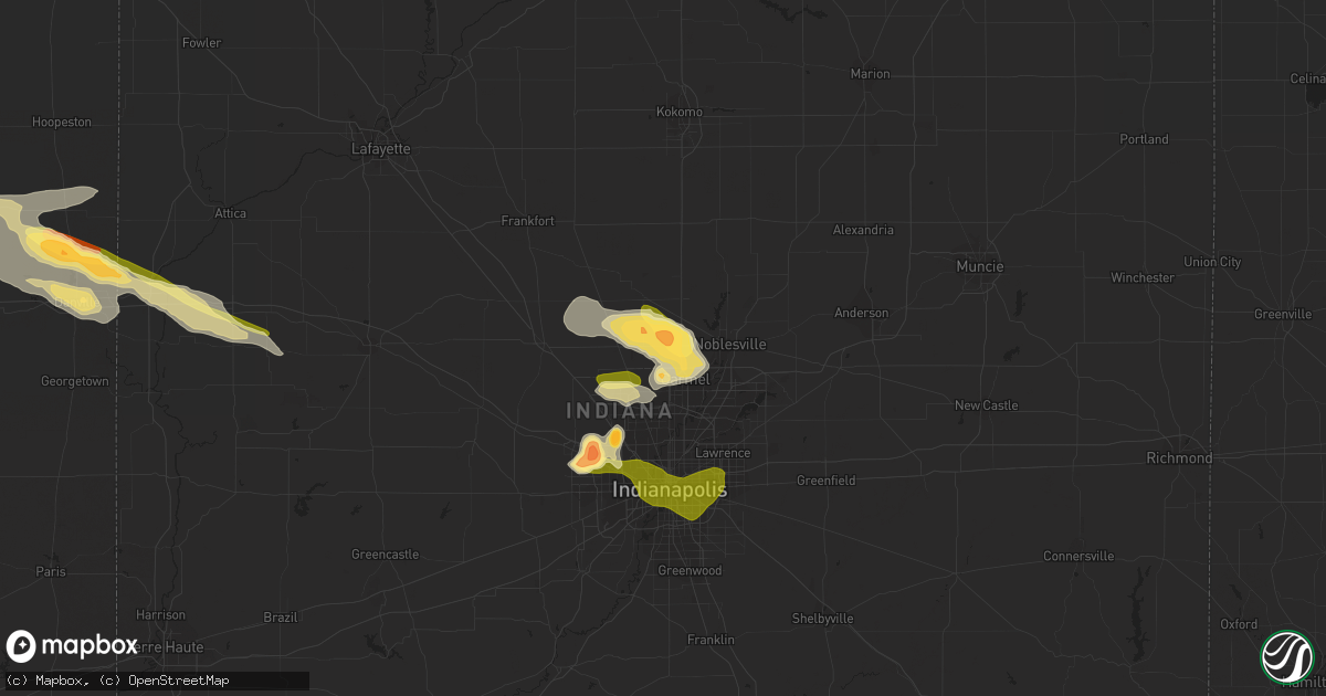
Hail Map in Westfield, IN on July 17, 2023
Get this storm
July 17 map
$229
one time, instant access
Download today. No call, no setup
Keep the $229
Bought the map and want the full workflow? Apply the entire $229 to a subscription within 7 days. None of it is wasted.
Every map, not just this one
This buys you this map. Subscription and you get every map we run, in the markets you choose from a few cities to whole states to nationwide. Plus real-time alerts the moment a storm fires.
Contact data
Name, contact info, occupancy, even credit band for addresses in the footprint. You go from where it hit to who to call.
Become the source they trust
Unlimited branding weather history reports on demand. You already have the documented answer ready for the property owner, and you are the one who showed up with it.
Property data and RoofTrace estimates
Pull up any address you have got, its value and the exact code rules for that jurisdiction, straight from One Click Code. Then RoofTrace estimates the squares, pitch, and roof value, priced the way you price.
Storm reports in Westfield, IN
Westfield, IN
| Date | Description |
|---|---|
| 07/17/20234:58 PM CDT | Report from mping: golf ball |
| 07/17/20234:58 PM CDT | A local report indicates 1.00 inch wind near 1 SW Westfield |
| 07/17/20234:50 PM CDT | Located at state road 32 and ditch road. Accompanied by hail up to the size of coin quarters and heavy rain. |
| 07/17/20234:50 PM CDT | At state road 32 and ditch road. Started with pea size and grew to quarter coin size. Heavy rain and estimated winds 55 to 60 mph. |
All States Impacted by Hail Map on July 17, 2023
All Cities Impacted by Hail Map on July 17, 2023
- Eddyville, IA
- Oskaloosa, IA
- Leigh, NE
- Clarkson, NE
- Cedar, IA
- Kirkville, IA
- Ottumwa, IA
- Fremont, IA
- Hedrick, IA
- Batavia, IA
- Howells, NE
- Schuyler, NE
- Dodge, NE
- Rogers, NE
- Scribner, NE
- North Bend, NE
- Fairfield, IA
- Eagleville, MO
- Hatfield, MO
- Ridgeway, MO
- Bethany, MO
- Fremont, NE
- Nickerson, NE
- Arlington, NE
- Hooper, NE
- Ames, NE
- Kennard, NE
- Blair, NE
- Valley, NE
- Washington, NE
- Bennington, NE
- Omaha, NE
- Carter Lake, IA
- Council Bluffs, IA
- Crescent, IA
- Gilman City, MO
- Trenton, MO
- Chillicothe, MO
- Jamesport, MO
- Chula, MO
- Knoxville, IA
- Milo, IA
- Pleasantville, IA
- Melcher Dallas, IA
- Lacona, IA
- Ackworth, IA
- Harvey, IA
- Tracy, IA
- Leighton, IA
- Pella, IA
- New Sharon, IA
- Chariton, IA
- Humeston, IA
- Williamson, IA
- Walnut, IA
- Atlantic, IA
- Lewis, IA
- Massena, IA
- Cumberland, IA
- Wiota, IA
- Bridgewater, IA
- Fontanelle, IA
- Greenfield, IA
- Orient, IA
- Glenwood, IA
- Silver City, IA
- Hastings, IA
- Imogene, IA
- Emerson, IA
- Essex, IA
- Malvern, IA
- Randolph, IA
- Shenandoah, IA
- Griswold, IA
- Elliott, IA
- Henderson, IA
- Red Oak, IA
- Centerville, MO
- Black, MO
- Braddyville, IA
- Blanchard, IA
- Elmo, MO
- Coin, IA
- Clearmont, MO
- College Springs, IA
- Clarinda, IA
- Burlington Junction, MO
- Skidmore, MO
- Maryville, MO
- Macksburg, IA
- Winterset, IA
- Osceola, IA
- Murray, IA
- Lorimor, IA
- Creston, IA
- Afton, IA
- Truro, IA
- Peru, IA
- Bunker, MO
- Lesterville, MO
- Barnard, MO
- Bolckow, MO
- Guilford, MO
- Florence, KS
- Burns, KS
- Leon, KS
- Ellington, MO
- Redford, MO
- Atlanta, KS
- Latham, KS
- Piedmont, MO
- El Dorado, KS
- Cambridge, KS
- Burden, KS
- Rosalia, KS
- Beaumont, KS
- Piedmont, KS
- Moline, KS
- Howard, KS
- Grenola, KS
- Mill Spring, MO
- Elk Falls, KS
- Elk City, KS
- Longton, KS
- Dexter, KS
- Cedar Vale, KS
- Winfield, KS
- Sedan, KS
- Peru, KS
- Niotaze, KS
- Maple City, KS
- Shidler, OK
- Newkirk, OK
- Chautauqua, KS
- Copan, OK
- Pawhuska, OK
- Havana, KS
- Dewey, OK
- Caney, KS
- Burbank, OK
- Bartlesville, OK
- Fairfax, OK
- Ochelata, OK
- Ramona, OK
- Nowata, OK
- Talala, OK
- Oologah, OK
- Claremore, OK
- Cassoday, KS
- Wisner, NE
- Beemer, NE
- Marion, KS
- Steelville, MO
- New Athens, IL
- Portsmouth, IA
- Logan, IA
- Woodbine, IA
- Albia, IA
- Cuba, MO
- Missouri Valley, IA
- Modale, IA
- Cedar Bluffs, NE
- Bourbon, MO
- Leasburg, MO
- Eldon, IA
- Libertyville, IA
- Douds, IA
- Selma, IA
- Anita, IA
- Hancock, IA
- Russell, IA
- Belleview, MO
- Bixby, MO
- Hillsboro, KS
- Minden, IA
- Persia, IA
- Neola, IA
- Shelby, IA
- Mineola, IA
- Platte Center, NE
- Columbus, NE
- Raymondville, MO
- Licking, MO
- Houston, MO
- Cedar Point, KS
- Herman, NE
- Beacon, IA
- Severy, KS
- Marissa, IL
- Lenzburg, IL
- New Virginia, IA
- Hugo, CO
- Avoca, IA
- Indianola, IA
- Hamilton, IA
- Bussey, IA
- Lucas, IA
- Birmingham, IA
- Potosi, MO
- Lovilia, IA
- Melrose, IA
- Independence, KS
- Coffeyville, KS
- Norwalk, IA
- Prole, IA
- Shannon City, IA
- Westboro, MO
- Rea, MO
- Union Star, MO
- Agency, IA
- Stockport, IA
- Elkhorn, NE
- Peabody, KS
- Walton, KS
- Hope, KS
- Abilene, KS
- Whitewater, KS
- Eureka, KS
- Potwin, KS
- Augusta, KS
- Keosauqua, IA
- Hillsboro, IA
- Bonaparte, IA
- Floris, IA
- Blakesburg, IA
- Bloomfield, IA
- Liberty Center, IA
- Saint Charles, IA
- Columbia, IA
- Chillicothe, IA
- University Park, IA
- Boss, MO
- Newton, KS
- Coulterville, IL
- Gypsum, KS
- Oakland, IA
- Cole Camp, MO
- Versailles, MO
- Stover, MO
- Lebanon, MO
- Osceola, MO
- Quincy, MO
- Weaubleau, MO
- Wheatland, MO
- Portage Des Sioux, MO
- Saint Charles, MO
- Florissant, MO
- Hazelwood, MO
- Saint Louis, MO
- Granite City, IL
- Venice, IL
- Madison, IL
- East Saint Louis, IL
- Lovejoy, IL
- Belleville, IL
- Stoutland, MO
- Richland, MO
- Waynesville, MO
- Saint Robert, MO
- Half Way, MO
- Bolivar, MO
- Polk, MO
- Buffalo, MO
- Rozel, KS
- Larned, KS
- Potomac, IL
- Danville, IL
- Bismarck, IL
- Covington, IN
- State Line, IN
- Pompano Beach, FL
- Coral Springs, FL
- Williamsport, IN
- Veedersburg, IN
- Hillsboro, IN
- Kinsley, KS
- Garfield, KS
- Lewis, KS
- Fair Grove, MO
- Pleasant Hope, MO
- Flemington, MO
- Strafford, MO
- Springfield, MO
- Rogersville, MO
- Marshfield, MO
- Fordland, MO
- Sparta, MO
- Bruner, MO
- Duke, MO
- Worden, IL
- Livingston, IL
- Seymour, MO
- Eureka, MO
- Fairmount, IL
- Sorento, IL
- Shelbyville, IL
- Catawissa, MO
- Hartville, MO
- Longview, IL
- Findlay, IL
- East Alton, IL
- Saint Clair, MO
- Pacific, MO
- Mountain Grove, MO
- Villa Grove, IL
- Saint James, MO
- Robertsville, MO
- Falcon, MO
- Witt, IL
- Oconee, IL
- Ballwin, MO
- Tower Hill, IL
- Lonedell, MO
- Staunton, IL
- Roby, MO
- Valley Park, MO
- Pana, IL
- Irving, IL
- Arcola, IL
- Taylor Springs, IL
- Hillsboro, IL
- Alhambra, IL
- Tuscola, IL
- Plato, MO
- Mansfield, MO
- Edwardsville, IL
- Walshville, IL
- High Ridge, MO
- Mount Olive, IL
- Sullivan, MO
- Homer, IL
- Lynchburg, MO
- South Roxana, IL
- Rolla, MO
- Roxana, IL
- Broadlands, IL
- Hartford, IL
- Grovespring, MO
- Newburg, MO
- Nokomis, IL
- Sullivan, IL
- Fenton, MO
- Edgar Springs, MO
- Cook Sta, MO
- Arthur, IL
- New Douglas, IL
- Rosamond, IL
- Philo, IL
- Ohlman, IL
- Lovington, IL
- Bethalto, IL
- Fithian, IL
- Atwood, IL
- Sidney, IL
- Union, MO
- Litchfield, IL
- Wood River, IL
- Pesotum, IL
- Tolono, IL
- Bethany, IL
- Moro, IL
- Butler, IL
- Assumption, IL
- Oakwood, IL
- Wildwood, MO
- Arcadia, IN
- Atlanta, IN
- Cicero, IN
- Noblesville, IN
- Westfield, IN
- Sheridan, IN
- Whitestown, IN
- Zionsville, IN
- Carmel, IN
- North Salem, IN
- Danville, IN
- Lizton, IN
- Pittsboro, IN
- Offerle, KS
- Oldfield, MO
- Ava, MO
- Garrison, MO
- Bradleyville, MO
- Chadwick, MO
- Greensburg, KS
- Thornfield, MO
- Theodosia, MO
- Rueter, MO
- Protem, MO
- Gainesville, MO
- Zanoni, MO
- Dora, MO
- Tecumseh, MO
- Caulfield, MO
- Bucklin, KS
- Avon, IN
- Indianapolis, IN
- Spearville, KS
- Ford, KS
- Mullinville, KS
- Pontiac, MO
- Peel, AR
- Isabella, MO
- Oakland, AR
- Yellville, AR
- Flippin, AR
- Bull Shoals, AR
- Mountain Home, AR
- Lakeview, AR
- Gassville, AR
- Cotter, AR
- Poplar Bluff, MO
- Fisk, MO
- Puxico, MO
- Brownsburg, IN
- Beech Grove, IN
- Raymore, MO
- Farmland, IN
- Winchester, IN
- Parker City, IN
- Pleasant Hill, MO
- Gravois Mills, MO
- Sunrise Beach, MO
- Camdenton, MO
- Climax Springs, MO
- Edwards, MO
- Roach, MO
- Harrisonville, MO
- Macks Creek, MO
- Eldridge, MO
- Tunas, MO
- Sturdivant, MO
- Zalma, MO
- Plainfield, IN
- Morristown, IN
- Shelbyville, IN
- Advance, MO
- Manilla, IN
- Homer, IN
- Rushville, IN
- Arlington, IN
- Bell City, MO
- Oran, MO
- Garden City, MO
- Liberty, IN
- College Corner, OH
- West College Corner, IN
- Camden, OH
- Harriet, AR
- Big Flat, AR
- Hollansburg, OH
- Fountain City, IN
- New Paris, OH
- New Madison, OH
- Eldorado, OH
- Arcanum, OH
- Minneola, KS
- Smithton, MO
- Sedalia, MO
- Edna, KS
- Bluejacket, OK
- Welch, OK
- Romney, IN
- Winchester, IL
- Godfrey, IL
- Dow, IL
- Elsah, IL
- Grafton, IL
- Lebanon, IN
- Thorntown, IN
- Collinsville, OK
- Rockville, IN
- Mora, MO
- Lowry City, MO
- Pittsburg, MO
- Hermitage, MO
- Fort Leonard Wood, MO
- Alton, IL
- Kaiser, MO
- Brumley, MO
- Tuscumbia, MO
- Ulman, MO
- Moweaqua, IL
- Dalton City, IL
- Cross Timbers, MO
- Warsaw, MO
- Laquey, MO
- Devils Elbow, MO
- Dixon, MO
- Palestine, WV
- Wappapello, MO
- Gillette, WY
- Winifrede, WV
- Eskdale, WV
- Hernshaw, WV
- Amesville, OH
- Athens, OH
- Patagonia, AZ
- Waynetown, IN
- New Market, IN
- Crawfordsville, IN
- Ladoga, IN
- New Ross, IN
- Eldon, MO
- Niangua, MO
- Bland, MO
- Owensville, MO
- Waycross, GA
- Jamestown, IN
- Belle, MO
- Clarksburg, OH
- Rosebud, MO
- Gerald, MO
- Brighton, MO
- Delaware, OK
- McGee, MO
- Charleston, WV
- Beulah, MO
- Vienna, MO
- Jefferson City, MO
- Linn, MO
- Westphalia, MO
- Freeburg, MO
- Koeltztown, MO
- Colfax, IN
- Clarks Hill, IN
- Armstrong, IL
- Frankfort, OH
- Washington Court House, OH
- Gainesville, FL
- Elkview, WV
- Tilton, IL
- Ogden, IL
- Rossville, IL
- Gifford, IL
- Penfield, IL
- Alvin, IL
- Henning, IL
- Collison, IL
- Fall River, KS
- Havre, MT
- Millstadt, IL
- Miami, WV
- Drybranch, WV
- Oberlin, LA
- Reeves, LA
- Kinder, LA
- Dry Creek, LA
- Afton, OK
- South West City, MO
- Fairland, OK
- Jay, OK
- Grove, OK
- Gravette, AR
- Sulphur Springs, AR
- Ragley, LA
- Linn Creek, MO
- Martinsville, MO
- Grant City, MO
- Crocker, MO
- Salem, MO
- Fairview Heights, IL
- Montreal, MO
- Singer, LA
- Taylorville, IL
- Osage Beach, MO
- Squires, MO
- Caseyville, IL
- Upper Tract, WV
- Petersburg, WV
- Jerome, MO
- Vinton, OH
- Modoc, IN
- Losantville, IN
- Chouteau, OK
- Pryor, OK
- Needham, AL
- Owasso, OK
- Wagoner, OK
- Inola, OK
- Catoosa, OK
- Wynona, OK
- Montezuma, IN
- Mecca, IN
- Lafayette, IN
- Frankfort, IN
- Bloomfield, MO
- Brixey, MO
- Nogales, AZ
- Sonoita, AZ
- Richmond Hill, GA
- Conway, MO
- South Charleston, WV
- Dunbar, WV
- Hartford City, IN
- Dunkirk, IN
- Deridder, LA
- Barnett, MO
- Dequincy, LA
- Vichy, MO
- Deepwater, MO
- Collins, MO
- Welch, WV
- Kimball, WV
- Williamsville, MO
- Linden, IN
- Ravenswood, WV
- Long Lane, MO
- Phillipsburg, MO
- Oakdale, LA
- Tipton, IN
- Carbon, IN
- Vail, AZ
- Portland, OH
- Saint Johns, FL
- Westpoint, IN
- Stonington, IL
- Collinsville, IL
- Marshall, AR
- Timbo, AR
- Onia, AR
- Fox, AR
- Leslie, AR
- Mountain View, AR
- Hardenville, MO
- Udall, MO
- Windyville, MO
- Marble Hill, MO
- Waverly, IL
- Auburn, IL
- Tucson, AZ
- Pawnee, IL
- Morrisonville, IL
- Kincaid, IL
- Palmer, IL
- Eaton, OH
- Oxford, OH
- Somerville, OH
- Mount Lemmon, AZ
- West Manchester, OH
- Lewisburg, OH
- Protection, KS
- Coldwater, KS
- Milroy, IN
- Laurel, IN
- Glenwood, IN
- Connersville, IN
- Metamora, IN
- Brookville, IN
- Quincy, IN
- Cloverdale, IN
- Gosport, IN
- Paragon, IN
- Hamilton, OH
- Peculiar, MO
- Spencer, IN
- Haviland, KS
- Creighton, MO
- Urich, MO
- Butler, MO
- Archie, MO
- Middletown, OH
- Franklin, OH
- Macomb, MO
- Rozet, WY
- Upton, WY
- Moorcroft, WY
- Branson, MO
- Dayton, OH
- Bellbrook, OH
- Waynesville, OH
- Spring Valley, OH
- Oregonia, OH
- Hollister, MO
- Omaha, AR
- Kirbyville, MO
- Lead Hill, AR
- Jackson, MO
- Oak Ridge, MO
- Cedarcreek, MO
- Cape Girardeau, MO
- Whitewater, MO
- Chaffee, MO
- Ashland, KS
- Norwood, MO
- Montrose, MO
- Appleton City, MO
- Harveysburg, OH
- Wilmington, OH
- Bloomington, IN
- Unionville, IN
- Chilhowee, MO
- Blairstown, MO
- Clinton, MO
- Leeton, MO
- Calhoun, MO
- Windsor, MO
- Lincoln, MO
- Harrison, AR
- Preston, MO
- Urbana, MO
- Everton, AR
- Valley Springs, AR
- Saint Joe, AR
- Wickliffe, KY
- Barlow, KY
- La Center, KY
- Kevil, KY
- Brookport, IL
- Smithland, KY
- Grand Rivers, KY
- Newcastle, WY
- Osage, WY
- Nashville, IN
- Gilbert, AR
- Harrison, NE
- Van Tassell, WY
- Lusk, WY
- Eddyville, KY
- Fredonia, KY
- Kuttawa, KY
- Marion, KY
- Tiline, KY
- Hill City, SD
- Edgemont, SD
- Custer, SD
- Hot Springs, SD
- Pringle, SD
- Buffalo Gap, SD
- Oral, SD
- Smithwick, SD
- Oelrichs, SD
- Springville, IN
- Bedford, IN
- Heltonville, IN
- Pine Ridge, SD
- Oglala, SD
- Medora, IN
- Campbellsburg, IN
- Vallonia, IN
- Norman, IN
- Scottsburg, IN
- Salem, IN
- Princeton, KY
- Greenville, MO
- Fairburn, SD
- Clinton, KY
- Brownstown, IN
- Elizabethtown, IN
- Columbus, IN
- Grammer, IN
- Newport, PA
- New Bloomfield, PA
- Garita, NM
- Maysville, KY
- Germantown, KY
- Freetown, IN
- Seymour, IN
- Farmersville, IL
- Chadron, NE
- Douglas, WY
- Henderson, NV
- Gonzales, LA
- Benton, KY
- Symsonia, KY
- Florence, MO
- New Straitsville, OH
- San Manuel, AZ
- Oracle, AZ
- Mammoth, AZ
- North Vernon, IN
- Commiskey, IN
- Olmsted, IL
- De Soto, MO
- Dittmer, MO
- Festus, MO
- Grubville, MO
- Luebbering, MO
- Hillsboro, MO
- Fillmore, IN
- Greencastle, IN
- New Palestine, IN
- Dawson Springs, KY
- West Paducah, KY
- Ledbetter, KY
- Bardwell, KY
- Boaz, KY
- Arlington, KY
- Charleston, MO
- Paducah, KY
- Calvert City, KY
- Cunningham, KY
- South Salem, OH
- Fortuna, MO
- Saint Augustine, FL
- Westport, IN
- Greensburg, IN
- Amado, AZ
- Trenton, OH
- Fishers, IN
- Milton, KY
- Madison, IN
- Kyle, SD
- Deputy, IN
- Patterson, MO
- Racine, OH
- Peridot, AZ
- Owaneco, IL
- Ellettsville, IN
- Lynn, IN
- Richmond, IN
- Crawford, NE
- Chestnutridge, MO
- Kissee Mills, MO
- Taneyville, MO
- Walnut Shade, MO
- Rockaway Beach, MO
- Forsyth, MO
- Russellville, MO
- Catlin, IL
- Perrysville, IN
- Westville, IL
- Martinsville, IN
- Poland, IN
- Coatesville, IN
- Fountaintown, IN
- Fifty Six, AR
- Kansas City, MO
- Scott City, MO
- Butlerville, IN
- East Lynne, MO
- Grandview, MO
- Lees Summit, MO
- Greenwood, MO
- Reeds Spring, MO
- Vevay, IN
- Carrollton, KY
- Paris Crossing, IN
- Solsberry, IN
- Letart, WV
- Mount Alto, WV
- Cottageville, WV
- Millwood, WV
- New Holland, OH
- Holden, MO
- Lake Charles, LA
- Nineveh, IN
- Trafalgar, IN
- East Prairie, MO
- New Madrid, MO
- Sulphur, LA
- Bridgeton, IN
- Rosedale, IN
- Brazil, IN
- Sells, AZ
- Divernon, IL
- Thayer, IL
- Virden, IL
- Clayton, IN
- Stilesville, IN
- Monrovia, IN
- Westlake, LA
- Vinton, LA
- Galion, OH
- Caledonia, OH
- Ashville, OH
- Circleville, OH
- Liverpool, PA
- Halifax, PA
- Millersburg, PA
- Sorrento, LA
- Saint Amant, LA
- Sabina, OH
- New Vienna, OH
- Clarksville, OH
- Brookville, OH
- West Alexandria, OH
- New Lebanon, OH
- Reelsville, IN
- Glendo, WY
- Huggins, MO
- Graff, MO
- Cabool, MO
- Freeburg, PA
- Selinsgrove, PA
- Middleburg, PA
- Mount Pleasant Mills, PA
- Lebanon, OH
- Springboro, OH
- Metropolis, IL
- Franklin, IN
- Freedom, IN
- Centerpoint, IN
- Stinesville, IN
- Morgantown, IN
- Scipio, IN
- Pulaski, IL
- Villa Ridge, IL
- Annapolis, MO
- Needham, IN
- Boggstown, IN
- Mount Olivet, KY
- Columbus, KY
- Waveland, IN
- Marshall, IN
- Spokane, MO
- Bloomfield, IN
- Flat Rock, IN
- Edinburgh, IN
- New Iberia, LA
- Brownsville, TN
- Ripley, WV
- Sandyville, WV
- West Columbia, WV
- Vulcan, MO
- Bainbridge, IN
- Russellville, IN
- Roachdale, IN
- Maurepas, LA
- Eugene, MO
- Henley, MO
- Greenfield, IN
- Mooresville, IN
- Vanduser, MO
- Brownwood, MO
- Sikeston, MO
- Glenallen, MO
- Gipsy, MO
- Mayslick, KY
- Seven Mile, OH
- Wilkinson, IN
- New Castle, IN
- Hagerstown, IN
- Chrisman, IL
- Bargersville, IN
- Middletown, IN
- Springport, IN
- Kingsville, MO
- Cedar Grove, TN
- Las Vegas, NM
- Waldron, IN
- Saint Paul, IN
- Story, AR
- Brooksville, KY
- Green Ridge, MO
- Milan, TN
- Medina, TN
- Camby, IN
- Cottonwood, AZ
- Cynthiana, KY
- Norfork, AR
- Drury, MO
- Gilbertsville, KY
- Fortville, IN
- Fairland, IN
- Pendleton, IN
- Ingalls, IN
- Greenwood, IN
- Whiteland, IN
- Knightstown, IN
- Shirley, IN
- Edinburg, IL
- Everett, PA
- Bedford, PA
- Attica, KS
- Jamestown, OH
- Xenia, OH
- Louisville, KY
- Finchville, KY
- Fisherville, KY
- Simpsonville, KY
- Shelbyville, KY
- Sellersburg, IN
- Jeffersonville, IN
- Prospect, KY
- Glenview, KY
- Pewee Valley, KY
- Crestwood, KY
- Bardstown, KY
- New Haven, KY
- Loretto, KY
- Springfield, KY
- Lebanon, KY
- Heartwell, NE
- Juniata, NE
- Kenesaw, NE
- Hastings, NE
- Holstein, NE
- Roseland, NE
- Ayr, NE
- Parksville, KY
- Gravel Switch, KY
- Brighton, IL
- Richland, MT
- Opheim, MT
- Stapleton, NE
- Wood, SD
- Wanblee, SD
- Duryea, PA
- Pittston, PA
- Wyoming, PA
- Clarks Summit, PA
- White River, SD
- Humboldt, TN
- Parmelee, SD
- Mission, SD
- Saint Francis, SD
- Boston, KY
- Elm Creek, NE
- Nicholasville, KY
- Long Valley, SD
- Kadoka, SD
- Croton, OH
- Johnstown, OH
- Trumbull, NE
- Harvard, NE
- Floyds Knobs, IN
- Pekin, IN
- Borden, IN
- Palmyra, IN
- Fredericksburg, IN
- Brady, NE
- Bedford, KY
- Worthville, KY
- Turners Station, KY
- Sanders, KY
- Norris, SD
- Sutton, NE
- Crothersville, IN
- Lexington, IN
- Austin, IN
- Elizabeth, IN
- Shepherdsville, KY
- Lebanon Junction, KY
- West Point, KY
- Anselmo, NE
- Maricopa, AZ
- Whitewater, MT
- Merna, NE
- Callaway, NE
- Arnold, NE
- Broken Bow, NE
- Versailles, KY
- Kearney, NE
- Shelton, NE
- Wood River, NE
- Gibbon, NE
- Kinmundy, IL
- Amherst, NE
- Riverdale, NE
- Salvisa, KY
- Laconia, IN
- Tunnelton, IN
- Orleans, IN
- Mitchell, IN
- Comfort, WV
- Cabin Creek, WV
- Point Pleasant, WV
- New Haven, WV
- Mason, WV
- Morrow, OH
- Central City, NE
- Wilber, NE
- Chillicothe, OH
- Friend, NE
- Harrodsburg, KY
- Lawrenceburg, KY
- Wilmore, KY
- Clarksville, IN
- Campbellsburg, KY
- Owenton, KY
- New Liberty, KY
- Hanover, IN
- Oolitic, IN
- Alma, IL
- Taylorsville, KY
- New Albany, IN
- Perryville, KY
- Bradfordsville, KY
- Atkinson, NE
- Shawnee, OH
- Taylor, NE
- Burwell, NE
- Ord, NE
- Ericson, NE
- Scotia, NE
- Elyria, NE
- North Loup, NE
- Brewster, NE
- Greeley, NE
- Wolbach, NE
- Saint Paul, NE
- Elba, NE
- Lame Deer, MT
- Birney, MT
- Crow Agency, MT
- Hardin, MT
- Rogersville, TN
- Sargent, NE
- Rutledge, TN
- Jefferson City, TN
- New Market, TN
- Hulett, WY
- Rosebud, SD
- Winner, SD
- Springview, NE
- Valentine, NE
- Hustonville, KY
- Dandridge, TN
- Sevierville, TN
- Columbia, KY
- Aladdin, WY
- Alva, WY
- Ainsworth, NE
- Bassett, NE
- Ballantine, MT
- Johnstown, NE
- Wood Lake, NE
- Long Pine, NE
- Weston, WY
- Ashton, NE
- Williamsburg, KY
- Parkers Lake, KY
- Whitley City, KY
- Elk Horn, KY
- Liberty, KY
- Dunnville, KY
- Firth, NE
- Adams, NE
- Middleburg, KY
- New Hope, KY
- Busby, MT
- Burnside, KY
- Huntley, MT
- Waynesburg, KY
- Eubank, KY
- Kings Mountain, KY
- Douglas, NE
- Windsor, KY
- Knifley, KY
- Nancy, KY
- Somerset, KY
- Sparks, NE
- Talbott, TN
- White Pine, TN
- Powder Springs, TN
- Blaine, TN
- Washburn, TN
- Morrill, KS
- Hiawatha, KS
- Farwell, NE
- Otter, MT
- Kearney, MO
- Lawson, MO
- Edgerton, MO
- Fair Play, MO
- Lone Jack, MO
- Oak Grove, MO
- Sneedville, TN
- Liberty, MO
- Holt, MO
- Excelsior Springs, MO
- Purdum, NE


