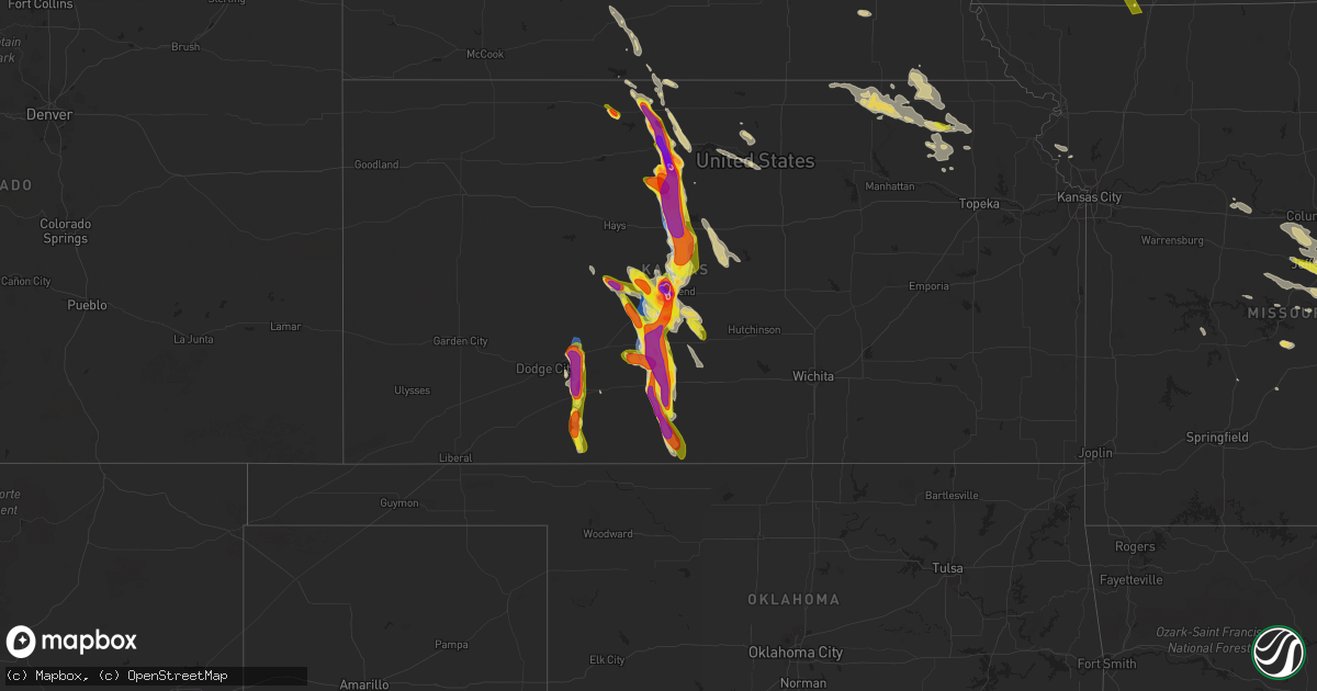
Hail Map on July 16, 2023
Get this storm
July 16 map
$229
one time, instant access
Download today. No call, no setup
Keep the $229
Bought the map and want the full workflow? Apply the entire $229 to a subscription within 7 days. None of it is wasted.
Every map, not just this one
This buys you this map. Subscription and you get every map we run, in the markets you choose from a few cities to whole states to nationwide. Plus real-time alerts the moment a storm fires.
Contact data
Name, contact info, occupancy, even credit band for addresses in the footprint. You go from where it hit to who to call.
Become the source they trust
Unlimited branding weather history reports on demand. You already have the documented answer ready for the property owner, and you are the one who showed up with it.
Property data and RoofTrace estimates
Pull up any address you have got, its value and the exact code rules for that jurisdiction, straight from One Click Code. Then RoofTrace estimates the squares, pitch, and roof value, priced the way you price.
States Impacted by Hail Map on July 16, 2023
Storm reports
Louisiana
| Date | Description |
|---|---|
| 07/16/20235:50 PM CDT | Large branch snapped from thunderstorm outflow. Time estimated based on radar. |
| 07/16/20235:00 PM CDT | Numerous trees and power poles were blown down across the parish. Damage is being assessed by the catahoula oep. |
| 07/16/20234:46 PM CDT | A tree was downed onto power lines on nugent street in jena. |
| 07/16/20234:31 PM CDT | A tree was downed in olla. |
| 07/16/20234:31 PM CDT | A tree was downed in the urania community. |
| 07/16/20234:30 PM CDT | A tree was downed onto a power line on joe white road. |
| 07/16/20234:30 PM CDT | A tree was downed across rowland road. |
| 07/16/20234:18 PM CDT | A tree was downed across highway 546 near leckie road. |
| 07/16/20234:11 PM CDT | A tree was blown down across boatner road just south of caney lake. |
| 07/16/20234:01 PM CDT | A large tree limb was downed onto highway 485 in powhatan. |
| 07/16/20233:59 PM CDT | Numerous trees were downed across much of union parish. Some trees fell onto structures and vehicles. |
| 07/16/20233:45 PM CDT | Numerous trees down across west union parish. |
| 07/16/20233:40 PM CDT | 100 foot hotel sign blown down just off exit 85 along interstate twenty. |
| 07/16/20233:40 PM CDT | Numerous trees and power lines were downed in ruston and throughout lincoln parish. Much of ruston and choudrant are without power. |
| 07/16/20233:36 PM CDT | Causeway mesonet measured 68mph wind gust. |
| 07/16/20233:35 PM CDT | Multiple trees down. |
| 07/16/20233:08 PM CDT | Numerous trees and power lines down. |
| 07/16/20232:46 PM CDT | Power poles snapped |
| 07/16/20232:46 PM CDT | Corrects previous tstm wnd dmg report from 4 ene eastwood. Tree down on power lines in the princeton community. |
| 07/16/20232:40 PM CDT | Power poles snapped |
| 07/16/20232:37 PM CDT | Tree down on power lines in the princeton community. |
| 07/16/20232:37 PM CDT | Shingles blown off. |
| 07/16/20232:35 PM CDT | A large tree fell onto a home on parkway drive in bossier city. |
| 07/16/20232:35 PM CDT | Multiple trees and power lines down in the shady grove subdivision in south bossier city. |
| 07/16/20232:34 PM CDT | A local report indicates 60 MPH wind near 1 NE Barksdale Air Forc |
| 07/16/20232:32 PM CDT | Power lines down on hallmark drive between hallmark circle and hillsboro drive. |
| 07/16/20232:31 PM CDT | Power lines down on garfield drive. |
| 07/16/20232:29 PM CDT | Trees snapped power poles broken. |
| 07/16/20232:27 PM CDT | Tree down across dixie shreveport highway near i-220 east. |
| 07/16/20232:19 PM CDT | Trees down onto highway 169 near south lakeshore drive. |
| 07/16/20232:18 PM CDT | Power lines down on wilkinson street between linwood ave and william ave. |
| 07/16/20232:13 PM CDT | Trees down across blanchard-furrh road between republic church road and highway 169 near the longwood community. |
| 07/16/20232:13 PM CDT | *** 1 inj *** a tree fell across highway 169 near blanchard-furrh road near the longwood community... Crushing a car with the female driver suffering serious injuries. |
| 07/16/20232:10 PM CDT | A local report indicates 60 MPH wind near 3 ESE Shreveport |
| 07/16/20232:03 PM CDT | Trees and power lines down on fairfield ave and stephenson st. |
| 07/15/20237:38 PM CDT | Roof damage to one home. Time estimated based on radar. |
| 07/15/20237:25 PM CDT | Several power poles down or leaning. Time estimated based on radar. |
Iowa
| Date | Description |
|---|---|
| 07/16/20236:55 AM CDT | Reported by knia/krls radio and trained spotters as well. |
| 07/16/20236:44 AM CDT | A local report indicates 1.00 inch wind near Mount Ayr |
| 07/16/20235:27 AM CDT | Report from mping: quarter |
| 07/16/20231:53 AM CDT | Delayed report. Time estimated from radar. |
New York
| Date | Description |
|---|---|
| 07/16/20235:10 PM CDT | Rte 9 nb/sb closed at english rd due to downed tree. |
| 07/16/202312:07 PM CDT | Report received at 107 pm of a tree down across rivka road near saugerties. |
| 07/16/20237:12 AM CDT | Portion of wittenburg road closed near woodstock due to downed trees. |
Texas
| Date | Description |
|---|---|
| 07/16/20231:55 PM CDT | Power poles snapped |
| 07/16/20231:48 PM CDT | Scattered trees and power lines down across mainly northern and eastern harrison county. |
| 07/16/20231:41 PM CDT | Trees and power lines down county wide. |
| 07/16/20231:40 PM CDT | Trees and power lines down county wide. |
| 07/16/20231:37 PM CDT | Scattered trees and power lines were downed across marion county. |
| 07/16/20231:14 PM CDT | Shingles blown off. |
| 07/16/20231:10 PM CDT | Corrects previous tstm wnd dmg report from 6 ese gilmer. Power poles broken. |
| 07/16/202312:55 PM CDT | Numerous trees down across western upshur county. |
| 07/16/202312:33 PM CDT | Tree down across road. |
| 07/16/202312:32 PM CDT | Large tree down. Power lines down. |
| 07/16/202311:00 AM CDT | Trees down and damage to homes in honey grove. Time estimated by radar. |
Oklahoma
| Date | Description |
|---|---|
| 07/16/202310:22 AM CDT | Measured at durant emergency operations center. |
Illinois
| Date | Description |
|---|---|
| 07/16/20236:34 PM CDT | Tree down in the county. |
| 07/16/20236:23 PM CDT | 11 different calls for trees and powerlines down in harrisburg alone. |
| 07/16/20236:18 PM CDT | Large tree split/snapped at the park in harrisburg. |
| 07/16/20236:03 PM CDT | At least 10 trees down in williamson county. |
| 07/16/20234:00 PM CDT | Report from mping: trees uprooted or snapped. |
| 07/16/20233:36 PM CDT | Report from mping: 3-inch tree limbs broken; power poles broken. |
Florida
| Date | Description |
|---|---|
| 07/16/20236:55 PM CDT | Orange trees uprooted. |
| 07/16/20234:59 PM CDT | Pws in sunrise florida at nw 96th ave measured a 58mph gust at 6pm. |
| 07/16/20232:49 PM CDT | A tree limb fell on a power line and resulted in a power outage near south duval street and bronough street. |
| 07/16/20232:44 PM CDT | Lake oke south end sfwmd. |
| 07/16/20231:55 PM CDT | Power lines down on i-10wb mm 208. |
| 07/16/20231:55 PM CDT | Tree blocking road on i-10 eb mm 162. |
| 07/16/20231:45 PM CDT | Tree down near chattahoochee. |
| 07/16/20231:13 PM CDT | Fhp website reports debris blocking southbound lanes and partially blocking northbound lanes on highway 221 along the taylor-madison county border. |
| 07/16/202312:50 PM CDT | Tree down along a road at falling waters state park. |
| 07/16/202312:26 PM CDT | Scattered trees and power lines down in holmes county. |
Kansas
| Date | Description |
|---|---|
| 07/16/20236:55 PM CDT | A local report indicates 1.00 inch wind near Macksville |
| 07/16/20236:50 PM CDT | A local report indicates 1.00 inch wind near Larned |
| 07/16/20236:50 PM CDT | A local report indicates 70 MPH wind near Larned |
| 07/16/20236:35 PM CDT | Report was received from social media. |
| 07/16/20236:30 PM CDT | Report from mping: 3-inch tree limbs broken; power poles broken. |
| 07/16/20236:30 PM CDT | Report from mping of 3-inch tree limbs broken; power poles broken. |
| 07/16/20236:27 PM CDT | Twitter picture sent of ping pong ball sized hail. |
| 07/16/20236:23 PM CDT | Law enforcement reported multiple power poles blown down. |
| 07/16/20236:15 PM CDT | Report sent via twitter of baseball sized hail with one softball sized piece of hail in the yard. Time is based on radar. |
| 07/16/20236:13 PM CDT | Hen egg to tennis ball size at eisenhower school. |
| 07/16/20236:08 PM CDT | Large trees down. 6 inch tree down. Also... Reported quarter size hail. |
| 07/16/20236:08 PM CDT | Report from mping: trees uprooted or snapped; roof blown off. |
| 07/16/20236:08 PM CDT | Report from mping of trees uprooted or snapped. Roof was blown off. |
| 07/16/20236:08 PM CDT | Part of the roof of a church was torn off in town according to a public report relayed via kake and ksn. Time is based on other reports. |
| 07/16/20236:08 PM CDT | Large trees down and six inch diameter tree down. Quarter size hail reported as well. |
| 07/16/20236:02 PM CDT | A local report indicates 1.75 inch wind near 2 NE Great Bend |
| 07/16/20236:02 PM CDT | Report from mping: golf ball |
| 07/16/20236:01 PM CDT | Report from mping: golf ball |
| 07/16/20236:01 PM CDT | A local report indicates 1.75 inch wind near 2 E Great Bend |
| 07/16/20236:01 PM CDT | A local report indicates 1.75 inch wind near 1 ENE Great Bend |
| 07/16/20235:59 PM CDT | Report from mping: golf ball |
| 07/16/20235:59 PM CDT | A local report indicates 1.75 inch wind near 2 ENE Great Bend |
| 07/16/20235:59 PM CDT | Numerous power poles completely snapped. Time is estimated. |
| 07/16/20235:58 PM CDT | 600 block of coolidge. |
| 07/16/20235:58 PM CDT | A local report indicates 1.00 inch wind near 2 E Great Bend |
| 07/16/20235:52 PM CDT | Sustained 45 to 50 mph with gusts of 55 to 60 mph. |
| 07/16/20235:35 PM CDT | Winds were estimated to be 60 to 70 mph. Time is estimated from radar. |
| 07/16/20235:34 PM CDT | Pea to dime size. |
| 07/16/20235:34 PM CDT | Mostly pea to dime sized hail. |
| 07/16/20235:28 PM CDT | Large tree limbs down. |
| 07/16/20235:28 PM CDT | Large tree limbs down. |
| 07/16/20235:25 PM CDT | A local report indicates 77 MPH wind near Russell Airport |
| 07/16/20235:21 PM CDT | A local report indicates 72 MPH wind near Russell Airport |
| 07/16/20235:21 PM CDT | Power lines down blocking the road. |
| 07/16/20235:21 PM CDT | Power lines down blocking the road. |
| 07/16/20235:20 PM CDT | All north windows are broken out at a farm. There are large limbs down as well. Time is estimated. |
| 07/16/20235:17 PM CDT | Semi overturned at mile marker 189 on interstate 70. |
| 07/16/20235:17 PM CDT | Semi overturned at mile marker 189 on interstate 70. |
| 07/16/20235:09 PM CDT | 5 power poles knocked on homer road from bunker hill to russell. |
| 07/16/20235:09 PM CDT | Brief tornado on interstate 70. |
| 07/16/20235:09 PM CDT | 5 power poles knocked down on homer road from bunker hill to russell. |
| 07/16/20235:04 PM CDT | A local report indicates 70 MPH wind near Russell Airport |
| 07/16/20234:58 PM CDT | A local report indicates 1.25 inch wind near 6 SSE Waldo |
| 07/16/20234:44 PM CDT | Penny to quarter size hail... Covered the ground. |
| 07/16/20234:44 PM CDT | Time verified by radar. |
| 07/16/20234:44 PM CDT | Penny to quarter sized hail covered the ground. |
| 07/16/20234:44 PM CDT | Time verified by radar. |
| 07/16/20234:25 PM CDT | Measured 58 mph gust. |
| 07/16/20234:25 PM CDT | A local report indicates 58 MPH wind near Waldo |
| 07/16/20234:19 PM CDT | A local report indicates 65 MPH wind near 10 ENE Natoma |
| 07/16/20234:16 PM CDT | A local report indicates 3.00 inch wind near 7 SSW Osborne |
| 07/16/20234:16 PM CDT | This is a corrected location from the earlier issued 3 inch hail report from 7ssw osborne. Hail size substantiated by emailed photo since posted on facebook and twitter |
| 07/16/20233:35 PM CDT | Delayed report of golf ball size hail that broke windows on home and vehicle and damaged vinyl siding. Time estimated from radar. |
| 07/16/20233:25 PM CDT | Social media report of ping pong ball hail in cedar... Ks. Time estimated from radar. |
| 07/16/20233:19 PM CDT | A local report indicates 1.75 inch wind near Phillipsburg |
| 07/16/20239:09 AM CDT | Relayed report from deputy. |
| 07/15/202310:05 PM CDT | A local report indicates 1.75 inch wind near Lake City |
| 07/15/20239:20 PM CDT | A local report indicates 1.50 inch wind near 3 SE Ford |
| 07/15/20239:13 PM CDT | A local report indicates 1.00 inch wind near 3 SE Ford |
| 07/15/20239:07 PM CDT | Report received from social media with pictures. |
| 07/15/20238:55 PM CDT | Report received from social media. |
| 07/15/20238:51 PM CDT | A local report indicates 1.50 inch wind near 6 NNW Ford |
| 07/15/20238:49 PM CDT | A local report indicates 60 MPH wind near 6 NNW Ford |
| 07/15/20238:40 PM CDT | Report received from social media with pictures. |
| 07/15/20237:42 PM CDT | A local report indicates 1.75 inch wind near 2 W Pratt |
| 07/15/20237:42 PM CDT | Time of event was corrected based on radar. |
| 07/15/20237:30 PM CDT | Report received through social media. |
| 07/15/20237:25 PM CDT | 4 inch tree limbs broken just south of us 54 and wes river road. |
| 07/15/20237:06 PM CDT | 3-inch tree limbs broken... And power poles broken in larned. |
Georgia
| Date | Description |
|---|---|
| 07/16/20234:20 PM CDT | Delayed report...social media post showing tin roof blown off a storage shed...time estimated based off radar. |
| 07/16/20233:25 PM CDT | Tree down off the intersection of 84 bypass and highway 3 in thomas county georgia. |
| 07/16/20233:00 PM CDT | Two trees were blown down in grady county. |
| 07/16/20232:40 PM CDT | Two trees were blown down in decatur county. |
South Dakota
| Date | Description |
|---|---|
| 07/16/20235:20 PM CDT | A local report indicates 60 MPH wind near 9 S Oelrichs |
Indiana
| Date | Description |
|---|---|
| 07/16/20236:31 PM CDT | 4 power poles down. |
| 07/16/20236:15 PM CDT | 4 power poles down from storms. Time estimated from radar. |
| 07/16/20236:03 PM CDT | 1-2 inch diameter branches down. Winds estimated 60-65 mph. Pea size hail. |
| 07/16/20236:00 PM CDT | Large tree snapped in half. |
| 07/16/20235:20 PM CDT | Late report of thunderstorm winds that downed 2 trees in the zionsville area. Time estimated by radar. |
Michigan
| Date | Description |
|---|---|
| 07/16/20235:40 PM CDT | Report on facebook of a tree down on a garage... Couple of dead trees down... And small branches on roadways. Picture of downed tree was provided. |
New Hampshire
| Date | Description |
|---|---|
| 07/16/20239:30 AM CDT | Downed tree blocking monza road. |
| 07/16/20239:24 AM CDT | Trees down on proctor hill rd as well as near silver lake. Time estimated based on radar. |
| 07/16/20239:24 AM CDT | Trees down on ridge road near hwy 122. Time estimated based on radar. |
| 07/16/20239:00 AM CDT | Delayed report. Trees down around lake massabesic. |
| 07/16/20239:00 AM CDT | Branches trees wires down. Power outages. |
Connecticut
| Date | Description |
|---|---|
| 07/16/20239:25 AM CDT | Tree down on wires - relayed by amateur radio. |
| 07/16/20239:24 AM CDT | In wethersfield... Several small trees uprooted... Flashing ripped off building... Large/bronze landscaping piece tipped over on silas deane hwy. |
| 07/16/20238:40 AM CDT | Tree and wires down on naubuc ave - relayed by amateur radio. |
| 07/16/20238:35 AM CDT | Trees down on wires multiple locations - relayed by amateur radio. |
| 07/16/20237:35 AM CDT | Large tree uprooted per picture on social media. Time estimated by radar. |
Nebraska
| Date | Description |
|---|---|
| 07/16/20236:45 PM CDT | Public reports quarter to golf ball sized hail 13 miles south and 5 east of hay springs. |
| 07/16/20236:25 PM CDT | Corrects the previous report of golf ball sized hail near rushville. Time and location estimate based on radar/video provided. |
| 07/16/20236:20 PM CDT | Trained spotter reports quarter sized hail... Time estimated by radar. |
| 07/16/20235:58 PM CDT | Hail lasted for 1 minute. |
| 07/16/20235:45 PM CDT | A local report indicates 1.00 inch wind near 5 NNW Chadron |
| 07/16/20236:53 AM CDT | A local report indicates 1.25 inch wind near Creston |
| 07/15/20238:00 PM CDT | Fire chief/trained spotter reports thunderstorm damage at local home; broken windows... Garden a complete loss... Vehicles damaged; ground was completely white from hai |
| 07/15/20238:00 PM CDT | Fire chief/trained spotter reports tennis ball sized hail. |
| 07/15/20237:25 PM CDT | Trained spotter estimates 70 mph wind gust near ellsworth. |
| 07/15/20237:25 PM CDT | Trained spotter reports golf ball sized hail near ellsworth. |
| 07/15/20237:12 PM CDT | Public reports golf ball sized hail via social media near rushville. |
Alabama
| Date | Description |
|---|---|
| 07/16/202312:56 PM CDT | Report of a tree falling on a car on county road 85. Injuries unknown at this time. |
Missouri
| Date | Description |
|---|---|
| 07/16/20233:52 PM CDT | Large oak tree snapped off. Via twitter with picture. |
| 07/16/20233:46 PM CDT | Report from mping: 3-inch tree limbs broken; power poles broken. |
| 07/16/20233:46 PM CDT | Several large trees and tree limbs blown down around pevely and herculaneum areas. Via pictures on facebook. |
| 07/16/20233:46 PM CDT | Report from mping: 3-inch tree limbs broken; power poles broken. Time estimated from radar. |
| 07/16/20233:41 PM CDT | Report from mping: 3-inch tree limbs broken; power poles broken. |
| 07/16/20233:40 PM CDT | Report from mping: 3-inch tree limbs broken; power poles broken. |
| 07/16/20233:39 PM CDT | Report from mping: 3-inch tree limbs broken; power poles broken. |
| 07/16/20233:38 PM CDT | Report from mping: 1-inch tree limbs broken; shingles blown off. Time estimated from radar. |
| 07/16/20233:35 PM CDT | Report from mping: 1-inch tree limbs broken; shingles blown off. |
| 07/16/20233:32 PM CDT | Wind estimated 50-60 mph at hampton ave and i-44. |
| 07/16/20233:27 PM CDT | In town. |
| 07/16/20233:19 PM CDT | A local report indicates 60 MPH wind near Old Mines |
| 07/16/20233:15 PM CDT | Thunderstorm winds snapped off a power pole with the transformer landing in nearby tree. Via picture on facebook post. |
| 07/16/20233:11 PM CDT | Large tree limb blown down. Via picture on twitter. |
| 07/16/20233:10 PM CDT | Several large tree limbs blown down. |
| 07/16/20233:07 PM CDT | Several large tree limbs blown down near intersection of highway 94 and pralle lane. Winds estimated around 60 mph. |
| 07/16/20233:05 PM CDT | Sign blown over onto a car. |
| 07/16/20233:03 PM CDT | Tree blown down and penny sized hail near intersection of highway 94 and highway dd. Via facebook post. |
| 07/16/20232:55 PM CDT | Numerous trees and power lines down reported by off-duty nws employee. |
| 07/16/20232:50 PM CDT | Report from mping: 1-inch tree limbs broken; shingles blown off. Time estimated from radar. |
| 07/16/20232:46 PM CDT | Large tree blown down on a road in town. Via picture on facebook. |
| 07/16/20232:45 PM CDT | Tree into powerline at wilf flower ln and hwy ee. |
| 07/16/20232:45 PM CDT | Report from mping: 3-inch tree limbs broken; power poles broken. |
| 07/16/20232:42 PM CDT | Tree down on powerline causing an outage. Time based on radar estimate. |
| 07/16/20232:40 PM CDT | Power lines down at n second and e main street. |
| 07/16/20232:24 PM CDT | Tree down on powerline causing outages. Time based on radar estimate. |
| 07/16/20232:21 PM CDT | A local report indicates 72 MPH wind near 3 NNE Warrenton |
| 07/16/20231:49 PM CDT | Two trees down over the roadway... One flag pole pushed into powerlines. |
| 07/16/20231:15 PM CDT | Trees down. Time based on radar. |
| 07/16/20231:00 PM CDT | Tree down on hwy 87 north of eldon. |
| 07/16/20234:39 AM CDT | Report from mping: quarter |
| 07/16/20234:31 AM CDT | Time estimated from radar. |
| 07/16/20233:55 AM CDT | Report from mping: quarter |
| 07/16/20233:49 AM CDT | Report from mping: quarter |
| 07/16/20233:43 AM CDT | Delayed report. Small trees down. Time estimated from radar. |
Arkansas
| Date | Description |
|---|---|
| 07/16/20234:05 PM CDT | Roof damage and trees down in the el dorado... Ar area. |
| 07/16/20233:55 PM CDT | Multiple trees and power lines were downed across union county. |
| 07/16/20233:08 PM CDT | Numerous trees and power lines down. |
| 07/16/20233:00 PM CDT | Pictures were posted to social media of dozens of trees that were downed in and near emerson. |
| 07/16/20232:50 PM CDT | 911 dispatch reported a tree down along cr 126 just east of stamps. |
| 07/16/20232:46 PM CDT | Tree down along county road 22 just south of lewisville. |
| 07/16/20232:25 PM CDT | Trees and power lines down across southern miller county. |
Massachusetts
| Date | Description |
|---|---|
| 07/16/20239:58 AM CDT | Numerous large trees uprooted across town. |
| 07/16/20239:56 AM CDT | Ef-0. Damage confined to trees. Non-continuous 2 mile path. |
| 07/16/20237:35 AM CDT | Tree down on old stage rd - relayed by amateur radio. |
Mississippi
| Date | Description |
|---|---|
| 07/16/20236:10 PM CDT | Numerous trees were blown down across the county. |
| 07/16/20235:30 PM CDT | A few trees and power lines were blown down across the northern portion of the county. |
Wisconsin
| Date | Description |
|---|---|
| 07/16/20236:00 PM CDT | Viewer reported three trees down to local media. Time estimated by radar. Size of trees unknown. |
| 07/15/20238:45 PM CDT | Power line and pole down. |
| 07/15/20238:30 PM CDT | Large branches down near smith park. Time estimated by radar. |
| 07/15/20238:16 PM CDT | Time estimated from radar. |
| 07/15/20238:12 PM CDT | Downburst winds |
| 07/15/20238:12 PM CDT | Several trees down in okee. Time estimated from radar. |
| 07/15/20238:11 PM CDT | Large tree down. Pontoon boat overturned at dock on lake wisconsin. Time estimated from radar. |
| 07/15/20237:53 PM CDT | Very large tree branch downed onto garage. Photo via social media. |
| 07/15/20237:45 PM CDT | Near oak hill cemetery in neenah. Wind speed measured. Time estimated by radar. |
| 07/15/20237:45 PM CDT | Corrects time of previous tstm wnd dmg report from menasha. Large branches down near smith park. Time estimated by radar. |
Pennsylvania
| Date | Description |
|---|---|
| 07/16/20238:54 AM CDT | Picture of trees down along spring lane and hagys mill road. Time estimated from radar. |
Cities Impacted by Hail Map on July 16, 2023
- Corning, KS
- Centralia, KS
- Goff, KS
- Talco, TX
- Mount Pleasant, TX
- Winfield, TX
- Mount Vernon, TX
- Cookville, TX
- Omaha, TX
- Scroggins, TX
- Leesburg, TX
- Pittsburg, TX
- Ore City, TX
- Daingerfield, TX
- Gilmer, TX
- Naples, TX
- Marietta, TX
- Hughes Springs, TX
- Avinger, TX
- Diana, TX
- Lone Star, TX
- Douglassville, TX
- Linden, TX
- Holdrege, NE
- Funk, NE
- Campbell, TX
- Cumby, TX
- Sulphur Springs, TX
- Havensville, KS
- Soldier, KS
- Colbert, OK
- Spearville, KS
- Emmett, KS
- Burchard, NE
- Axtell, KS
- Summerfield, KS
- Paris, TX
- Hanover, KS
- Point, TX
- Emory, TX
- Longview, TX
- Clatonia, NE
- Cortland, NE
- Hallam, NE
- Wetmore, KS
- Mill Creek, OK
- Mannsville, OK
- Riverdale, NE
- Windom, TX
- Honey Grove, TX
- Ben Franklin, TX
- Pecan Gap, TX
- Ladonia, TX
- Klondike, TX
- Cooper, TX
- Roxton, TX
- Bennington, OK
- Walters, OK
- Geronimo, OK
- Sumner, TX
- Arthur City, TX
- Holton, KS
- Pawnee City, NE
- Platte City, MO
- Dearborn, MO
- Weston, MO
- Telephone, TX
- Winnsboro, TX
- Waterville, KS
- Bremen, KS
- Home, KS
- Marysville, KS
- Onaga, KS
- Frankfort, KS
- Duncan, OK
- Quitman, TX
- Mineola, TX
- Alba, TX
- Blue Rapids, KS
- Powderly, TX
- Baileyville, KS
- Springer, OK
- Westville, FL
- Ponce De Leon, FL
- Hendrix, OK
- Delia, KS
- Vermillion, KS
- Ravenna, TX
- Petty, TX
- Ivanhoe, TX
- Arlington, TX
- Fort Worth, TX
- Beattie, KS
- Seneca, KS
- Wolfe City, TX
- Commerce, TX
- Wills Point, TX
- Davis, OK
- Bokchito, OK
- Savoy, TX
- Hollenberg, KS
- Oketo, KS
- Morrowville, KS
- Washington, KS
- Jefferson, TX
- Harleton, TX
- Marshall, TX
- Karnack, TX
- Bivins, TX
- Mooringsport, LA
- Waskom, TX
- Shreveport, LA
- Oil City, LA
- Belcher, LA
- Vivian, LA
- Blanchard, LA
- Warrenton, MO
- Wright City, MO
- Foristell, MO
- Wentzville, MO
- Marthasville, MO
- Haughton, LA
- Minden, LA
- Benton, LA
- Bossier City, LA
- Cotton Valley, LA
- Barksdale Afb, LA
- Princeton, LA
- Doyline, LA
- Defiance, MO
- O'Fallon, MO
- Lake Saint Louis, MO
- Kensington, KS
- Agra, KS
- Athol, KS
- Gaylord, KS
- Cedar, KS
- Phillipsburg, KS
- Sibley, LA
- Jamestown, LA
- Dubberly, LA
- Heflin, LA
- Homer, LA
- Athens, LA
- Arcadia, LA
- Dubach, LA
- Gibsland, LA
- Simsboro, LA
- Bienville, LA
- Quitman, LA
- Ruston, LA
- Shipman, IL
- Carlinville, IL
- Festus, MO
- Hillsboro, MO
- Pevely, MO
- Herculaneum, MO
- Osborne, KS
- Portis, KS
- Alton, KS
- Glade, KS
- Valmeyer, IL
- Crystal City, MO
- Prairie Du Rocher, IL
- Fults, IL
- Red Bud, IL
- Grambling, LA
- Farmerville, LA
- Choudrant, LA
- Downsville, LA
- Calhoun, LA
- Chatham, LA
- Eros, LA
- West Monroe, LA
- Waldo, KS
- Natoma, KS
- Columbia, LA
- Luray, KS
- Paradise, KS
- Lucas, KS
- Russell, KS
- Bunker Hill, KS
- Dorrance, KS
- Sorento, IL
- Walshville, IL
- Panama, IL
- Donnellson, IL
- Greenville, IL
- Wilson, KS
- Oelrichs, SD
- Chadron, NE
- Pine Ridge, SD
- Lebanon, IN
- Brownsburg, IN
- Zionsville, IN
- Pittsboro, IN
- Whitestown, IN
- Indianapolis, IN
- Hay Springs, NE
- Hoisington, KS
- Claflin, KS
- Holyrood, KS
- Great Bend, KS
- Ellinwood, KS
- Bison, KS
- Otis, KS
- Rush Center, KS
- Albert, KS
- Olmitz, KS
- Pawnee Rock, KS
- St John, KS
- Larned, KS
- Wounded Knee, SD
- Batesland, SD
- Manderson, SD
- Stover, MO
- Covington, IN
- Perrysville, IN
- Buffalo, MO
- Meta, MO
- Abita Springs, LA
- Covington, LA
- Herrin, IL
- Johnston City, IL
- Marion, IL
- Jena, LA
- Jonesville, LA
- Bland, MO
- Mount Sterling, MO
- Owensville, MO
- Hermann, MO
- Morrison, MO
- Ringgold, LA
- Mount Olive, IL
- Stoutland, MO
- Montreal, MO
- Kilgore, TX
- Dodson, LA
- Rocky Mount, MO
- Eldon, MO
- Como, TX
- Fidelity, IL
- Piasa, IL
- Brighton, IL
- Magnolia, AR
- Bogalusa, LA
- Quincy, MO
- Wheatland, MO
- Campti, LA
- Natchitoches, LA
- Edgemont, SD
- Nacogdoches, TX
- Franklinton, LA
- Kiln, MS
- Tullos, LA
- Jewell, KS
- Amite, LA
- Vancleave, MS
- Carmel, IN
- Lebanon, KS
- Smith Center, KS
- Phillips, WI
- Kentwood, LA
- Springhill, LA
- Taylor, AR
- Russellville, MO
- Barnett, MO
- Randall, KS
- Jamestown, KS
- Beloit, KS
- Moss Point, MS
- Belle, MO
- Sainte Genevieve, MO
- Castor, LA
- Saint Thomas, MO
- Henley, MO
- Tuscumbia, MO
- Logansport, LA
- Jupiter, FL
- Hobe Sound, FL
- Mansfield, LA
- Osyka, MS
- Freeburg, MO
- Argyle, MO
- Koeltztown, MO
- Jefferson City, MO
- Saint Elizabeth, MO
- Eugene, MO
- Westphalia, MO
- Staunton, IL
- Phillipsburg, MO
- Jeanerette, LA
- Baldwin, LA
- Franklin, LA
- Coushatta, LA
- Jonesburg, MO
- Cuba, MO
- Ashland, LA
- Sullivan, MO
- Richwoods, MO
- Lonedell, MO
- Netawaka, KS
- Glenmora, LA
- Joaquin, TX
- Grand Cane, LA
- Lisbon, LA
- Litchfield, IL
- Marksville, LA
- Hawkins, TX
- New Iberia, LA
- Delcambre, LA
- Madisonville, LA
- Glasco, KS
- Simpson, KS
- Sarepta, LA
- Plain Dealing, LA
- Magnolia, MS
- Centreville, MS
- Olla, LA
- Trout, LA
- Harrisonburg, LA
- New Douglas, IL
- Leasburg, MO
- Riverton, NE
- Carriere, MS
- Picayune, MS
- Cairo, GA
- Whigham, GA
- Robertsville, MO
- Belle Rose, LA
- Richland, MO
- Sikes, LA
- Hineston, LA
- Lettsworth, LA
- Bourbon, MO
- Bainbridge, GA
- Climax, GA
- Linn, MO
- Loose Creek, MO
- Damascus, GA
- Hallsville, TX
- Independence, LA
- Greenville, FL
- Monterey, LA
- Dittmer, MO
- Catawissa, MO
- Cedar Hill, MO
- Woodbine, GA
- Poplarville, MS
- Potosi, MO
- Goldonna, LA
- Natchez, MS
- Versailles, MO
- Olean, MO
- Gillespie, IL
- Butler, IL
- Chesterfield, IL
- Medora, IL
- Greensburg, LA
- Saint Charles, MO
- Saint Peters, MO
- Ponchatoula, LA
- Hammond, LA
- Pollock, LA
- Glen Elder, KS
- Pittsburg, IL
- Bush, LA
- Bunker Hill, IL
- Pocahontas, IL
- Worden, IL
- Livingston, IL
- Alhambra, IL
- Fayette, MS
- Union Church, MS
- Pattison, MS
- Lorman, MS
- Macksville, KS
- Belpre, KS
- Hazlehurst, MS
- Hermanville, MS
- Alliance, NE
- Ellsworth, NE
- Gordon, NE
- Merriman, NE
- Byers, KS
- Iuka, KS
- Pratt, KS
- Haviland, KS
- Lakeside, NE
- Bingham, NE
- Oshkosh, NE
- Coats, KS
- Sawyer, KS
- Nekoma, KS
- Ashby, NE
- Sun City, KS
- Medicine Lodge, KS
- Lewellen, NE
- Arthur, NE
- Lemoyne, NE
- Farmington, CT
- West Hartford, CT
- New Britain, CT
- Newington, CT
- Hartford, CT
- Wethersfield, CT
- East Hartford, CT
- Windsor, CT
- South Windsor, CT
- Berlin, CT
- Rocky Hill, CT
- East Berlin, CT
- Cromwell, CT
- Glastonbury, CT
- South Glastonbury, CT
- Manchester, CT
- Vernon Rockville, CT
- Bolton, CT
- Coventry, CT
- Stafford Springs, CT
- Tolland, CT
- Ellington, CT
- Willington, CT
- Storrs Mansfield, CT
- Keystone, NE
- Offerle, KS
- Bucklin, KS
- Ford, KS
- Lewis, KS
- Hudson, KS
- Sylvia, KS
- Lake City, KS
- Minneola, KS
- Ashland, KS
- Hardtner, KS
- Kiowa, KS
- Creal Springs, IL
- Fort Necessity, LA
- Winnsboro, LA
- Duson, LA
- Lafayette, LA
- Muscoda, WI
- Boscobel, WI
- Kingman, IN
- Veedersburg, IN
- Saint Marys, KS
- Mobile, AL
- Eight Mile, AL
- Dequincy, LA
- Ragley, LA
- New Ross, IN
- Ladoga, IN
- Roachdale, IN
- North Salem, IN
- Crawfordsville, IN
- Marshall, IN
- Greenfield, IN
- Ellsworth, KS
- Lorraine, KS
- Tallulah, LA
- Newellton, LA
- Rushville, NE
- Golconda, IL
- Simpson, IL
- Vienna, IL
- Waupaca, WI
- Amherst, WI
- Merrimac, WI
- North Freedom, WI
- Lodi, WI
- Baraboo, WI
- Prairie Du Sac, WI
- Circleville, KS
- Roxie, MS
- Campbellsburg, IN
- Clayton, LA
- Lake Charles, LA
- Mccordsville, IN
- Ferriday, LA
- Vicksburg, MS
- Sicily Island, LA
- Gilbert, LA
- West Frankfort, IL
- Carterville, IL
- Stonefort, IL
- Energy, IL
- Fort Lauderdale, FL
- Lucedale, MS
- Kanopolis, KS
- Sylvan Grove, KS
- Loganville, WI
- Plain, WI
- Woodville, MS
- Reeves, LA
- Wesson, MS
- Geneseo, KS
- Porterfield, WI
- Wallace, MI
- Neenah, WI
- Kinder, LA
- Mitchell, IN
- Orleans, IN
- Richland Center, WI
- Soldiers Grove, WI
- Blue River, WI
- Hillpoint, WI
- Rayne, LA
- Gays Mills, WI
- Cazenovia, WI
- Jennings, LA
- Sawyerville, IL
- Enterprise, LA
- Reedsville, WI
- Abbeville, LA
- Maurice, LA
- New Burnside, IL
- Menasha, WI
- Larsen, WI
- Loxley, AL
- Bay Minette, AL
- Stapleton, AL
- Broxton, GA
- Aimwell, LA
- Jamestown, IN
- Eddyville, IL
- Eden, WI
- Pepperell, MA
- Townsend, MA
- Hollis, NH
- Brookline, NH
- Merrimack, NH
- Nashua, NH
- Amherst, NH
- Bloomfield, CT
- Kimballton, IA
- Audubon, IA
- Elk Horn, IA
- Exira, IA
- Brayton, IA
- Anita, IA
- Stuart, IA
- Menlo, IA
- Sauk City, WI
- Poynette, WI
- Arlington, WI
- Fond Du Lac, WI
- Winterset, IA
- Earlham, IA
- Dexter, IA
- Saint Cloud, WI
- Campbellsport, WI
- Mount Calvary, WI
- Glenbeulah, WI
- Persia, IA
- Shelby, IA
- Avoca, IA
- Columbia, IL
- Saint Charles, IA
- Prole, IA
- Bevington, IA
- Indianola, IA
- Atlantic, IA
- Blackwell, MO
- De Soto, MO
- Coulterville, IL
- Pinckneyville, IL
- Tamaroa, IL
- Du Quoin, IL
- California, MO
- Lohman, MO
- Centertown, MO
- Marshall, MO
- Harlan, IA
- Oconto, NE
- Portsmouth, IA
- Lexington, NE
- Callaway, NE
- Danville, IN
- Eddyville, NE
- Campbell Hill, IL
- McCracken, KS
- Alexander, KS
- Deputy, IN
- Scottsburg, IN
- Woodbine, IA
- Panama, IA
- Gerald, MO
- Rosebud, MO
- New Bloomfield, MO
- Arnold, NE
- Saint Louis, MO
- Chamois, MO
- Vallonia, IN
- Tebbetts, MO
- Austin, IN
- Salem, IN
- Galatia, IL
- Downs, KS
- High Ridge, MO
- Eureka, MO
- House Springs, MO
- Rio Grande City, TX
- Wilcox, NE
- Leslie, MO
- Beaufort, MO
- Stafford, KS
- Saint Clair, MO
- Goshen, KY
- Charlestown, IN
- Union, MO
- Marissa, IL
- Adair, IA
- Hartsburg, MO
- Jamestown, MO
- Boonville, MO
- Columbia, MO
- Wooldridge, MO
- Prairie Home, MO
- Ashland, MO
- Bonnots Mill, MO
- Holts Summit, MO
- Mulkeytown, IL
- Turon, KS
- Comanche, OK
- Bloomsdale, MO
- North Vernon, IN
- Vernon, IN
- New Athens, IL
- Imperial, MO
- Pacific, MO
- Ballwin, MO
- Fenton, MO
- Freeburg, IL
- Waterloo, IL
- Millstadt, IL
- East Carondelet, IL
- Wildwood, MO
- Arnold, MO
- Valley Park, MO
- Belleville, IL
- Smithton, IL
- Sherwood, WI
- New Haven, MO
- New Palestine, IN
- Brownstown, IN
- Crestwood, KY
- Buckner, KY
- La Grange, KY
- Marysville, IN
- Nabb, IN
- Otisco, IN
- Percy, IL
- Cutler, IL
- Sesser, IL
- Nelson, MO
- Blackwater, MO
- Wright, KS
- Dodge City, KS
- Crothersville, IN
- Hamlin, IA
- Fontanelle, IA
- Bridgewater, IA
- Soldier, IA
- Moorhead, IA
- Dunlap, IA
- Logan, IA
- Neola, IA
- Minden, IA
- Herman, NE
- Tekamah, NE
- Craig, NE
- Blair, NE
- Greenfield, IA
- Creston, IA
- Prescott, IA
- Orient, IA
- Saint Mary, MO
- Elgin, NE
- Petersburg, NE
- Albion, NE
- Cromwell, IA
- Newman Grove, NE
- Lenox, IA
- Shannon City, IA
- Perryville, MO
- Decatur, NE
- Lindsay, NE
- Laurel, NE
- Dixon, NE
- Coleridge, NE
- Diagonal, IA
- Mount Ayr, IA
- Saint Edward, NE
- Madison, NE
- Humphrey, NE
- Wayne, NE
- Concord, NE
- Blencoe, IA
- Little Sioux, IA
- Knoxville, IA
- Harvey, IA
- Tracy, IA
- Bussey, IA
- Oskaloosa, IA
- Creston, NE
- Wakefield, NE
- Eddyville, IA
- Leighton, IA
- Leigh, NE
- Hatfield, MO
- Eagleville, MO
- Martinsville, MO
- Kellerton, IA
- Franklin, NE
- Bloomington, NE
- Pisgah, IA
- Marne, IA
- Wiota, IA
- Kiron, IA
- Vail, IA
- Deloit, IA
- Arcadia, IA
- Breda, IA
- Westside, IA
- Gray, IA
- Manning, IA
- Manilla, IA
- Casey, IA
- Aspinwall, IA
- Irwin, IA
- Naponee, NE
- Hildreth, NE
- Oakland, NE
- Karnak, IL
- Belknap, IL
- Boss, MO
- Davisville, MO
- Ellis Grove, IL
- Walsh, IL
- Platte Center, NE
- Bonne Terre, MO
- Park Hills, MO
- Leadwood, MO
- Mineral Point, MO
- Central City, NE
- Marquette, NE
- Hordville, NE
- Lyons, NE
- Royalton, IL
- Freeman Spur, IL
- Orient, IL
- Zeigler, IL
- Steelville, MO
- Raleigh, IL
- Irondale, MO
- Farmington, MO
- French Village, MO
- Cadet, MO
- Elkville, IL
- Vergennes, IL
- Saint Marys, IA
- Patterson, IA
- Viburnum, MO
- Bixby, MO
- Cypress, IL
- Sumner, NE
- Broken Bow, NE
- Overton, NE
- Onawa, IA
- Belgrade, MO
- Columbus, NE
- Saint James, MO
- Whittington, IL
- Benton, IL
- Scheller, IL
- Chester, IL
- Vichy, MO
- Vienna, MO
- Fletcher, MO
- Axtell, NE
- Elm Creek, NE
- Hancock, IA
- Missouri Valley, IA
- Anselmo, NE
- Hampton, NE
- Bradshaw, NE
- Polk, NE
- Mondamin, IA
- Stanton, NE
- Norfolk, NE
- Massena, IA
- Tingley, IA
- Kirkman, IA
- Fulton, MO
- Redfield, IA