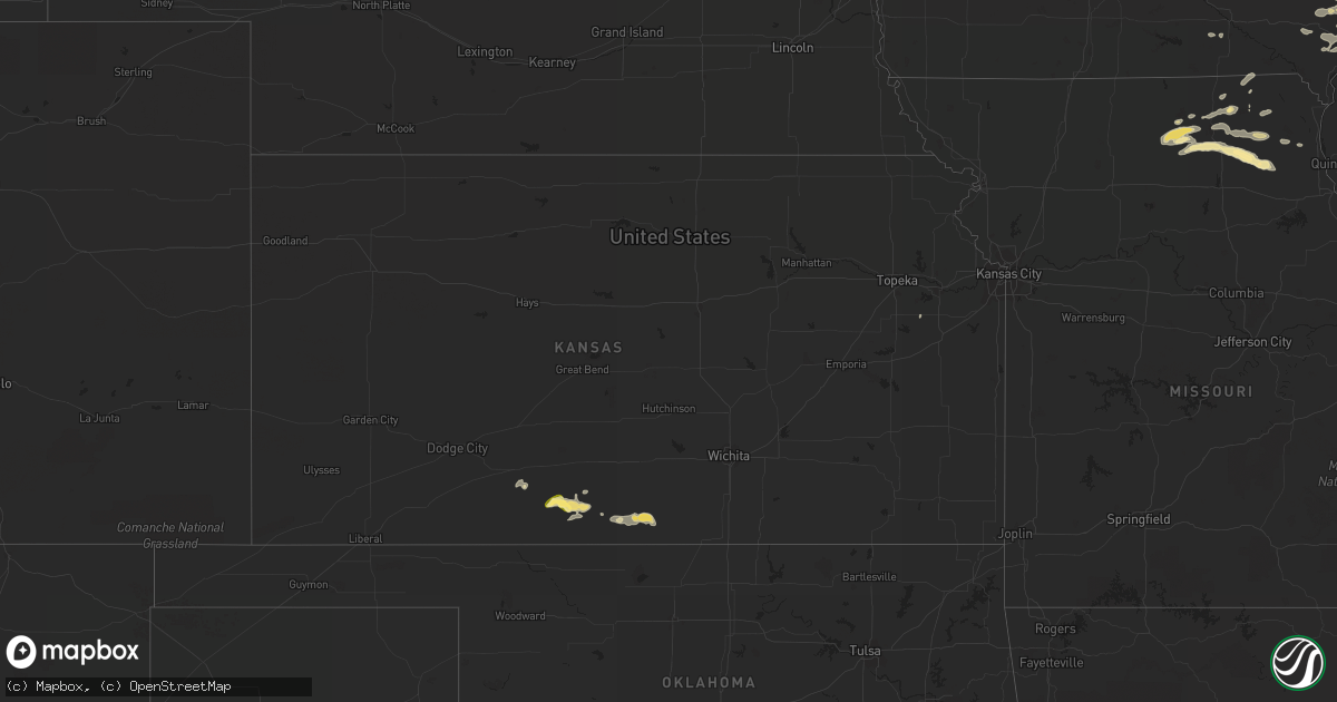
Hail Map in Kansas on July 16, 2015
Get this storm
July 16 map
$229
one time, instant access
Download today. No call, no setup
Keep the $229
Bought the map and want the full workflow? Apply the entire $229 to a subscription within 7 days. None of it is wasted.
Every map, not just this one
This buys you this map. Subscription and you get every map we run, in the markets you choose from a few cities to whole states to nationwide. Plus real-time alerts the moment a storm fires.
Contact data
Name, contact info, occupancy, even credit band for addresses in the footprint. You go from where it hit to who to call.
Become the source they trust
Unlimited branding weather history reports on demand. You already have the documented answer ready for the property owner, and you are the one who showed up with it.
Property data and RoofTrace estimates
Pull up any address you have got, its value and the exact code rules for that jurisdiction, straight from One Click Code. Then RoofTrace estimates the squares, pitch, and roof value, priced the way you price.
Storm reports in Kansas
Kansas
| Date | Description |
|---|---|
| 07/15/20159:55 PM CDT | Trained spotter reports branches blocking or partially blocking the roads in anthony of 3 to 4 inches. |
| 07/15/20159:55 PM CDT | A local report indicates 61 MPH wind near 1 SSW HARPER |
| 07/15/20159:55 PM CDT | Law enforcement reporting branches of 6 to 8 inches in diameter partially blocking roads. |
| 07/15/20159:53 PM CDT | Trained spotter estimates 70 mph winds and pea sized hail. |
| 07/15/20159:50 PM CDT | Tree broken off at the trunk with an estiment of the truck being 10-12 inches in diameter. |
| 07/15/20159:43 PM CDT | A local report indicates 60 MPH wind near 4 E ATTICA |
| 07/15/20159:05 PM CDT | A local report indicates 60 MPH wind near 5 ESE LAKE CITY |
| 07/15/20158:30 PM CDT | Pea sized hail and heavy rain fell. |
| 07/15/20158:25 PM CDT | Winds estimated at 60 mph blew down a residential television tower. |
| 07/15/20158:00 PM CDT | A local report indicates 74 MPH wind near 6 SW LAKE CITY |
| 07/15/20157:52 PM CDT | The hail was stripping leaves from trees. |
All States Impacted by Hail Map on July 16, 2015
Cities Impacted by Hail Map on July 16, 2015
- Eden, SD
- Roslyn, SD
- Waubay, SD
- Webster, SD
- Grenville, SD
- Burlington, IA
- Stronghurst, IL
- Carman, IL
- West Burlington, IA
- Gladstone, IL
- Biggsville, IL
- Wishek, ND
- Howard, SD
- Iroquois, SD
- De Smet, SD
- Carthage, SD
- Vega, TX
- Drakesville, IA
- Blakesburg, IA
- Unionville, IA
- Beardsley, MN
- Leola, SD
- Hosmer, SD
- Long Lake, SD
- Ashley, ND
- Delavan, IL
- McLean, IL
- Atlanta, IL
- Armington, IL
- Wapello, IA
- Oakville, IA
- Mediapolis, IA
- Lehr, ND
- Northville, SD
- Colman, SD
- Wentworth, SD
- Pekin, IL
- Milan, MO
- Green City, MO
- Green Castle, MO
- Novinger, MO
- Sawyerville, AL
- Camden, AL
- Coy, AL
- Jefferson, SD
- Ponca, NE
- Manito, IL
- Hecla, SD
- Sharon, KS
- Hazelton, KS
- Pampa, TX
- Princeville, IL
- Tennessee, IL
- Preston, MS
- Amarillo, TX
- Charter Oak, IA
- Anthony, KS
- Attica, KS
- Harper, KS
- Canton, IL
- La Plata, MO
- Kirksville, MO
- Lake City, KS
- Sun City, KS
- Medicine Lodge, KS
- Wilmore, KS
- Ellendale, ND
- Sheldon, ND
- Novelty, MO
- Groom, TX
- Cuba, IL
- Macomb, IL
- Colchester, IL
- Crawfordsville, IA
- Winfield, IA
- Laurel, NE
- Hartington, NE
- Newcastle, NE
- Roscoe, SD
- Shelbyville, MO
- Bethel, MO
- Leonard, MO
- Britton, SD
- Lake City, SD
- Grand Junction, IA
- Dana, IA
- Hubbard, NE
- Jackson, NE
- Catherine, AL
- Clinton, IL
- Beaver Creek, MN
- Luverne, MN
- Downing, MO
- Queen City, MO
- Vredenburgh, AL
- Oldham, SD
- Morning Sun, IA
- Mount Pleasant, IA
- Yarmouth, IA
- Mount Union, IA
- Frederick, SD
- Memphis, MO
- Milton, IA
- Edina, MO
- Vermillion, SD
- Burbank, SD
- Skellytown, TX
- New Boston, MO
- Hurdland, MO
- Dewitt, IL
- Greentop, MO
- Paton, IA
- Frazee, MN
- Seaton, IL
- New London, IA
- Sperry, IA
- Oquawka, IL
- Overbrook, KS
- Sisseton, SD
- Elk Point, SD
- Hills, MN
- Ogden, IA
- Mclean, TX
- Campo, CO
- De Kalb, MS
- Brashear, MO
- Knox City, MO
- Norfolk, NE
- Smithfield, IL
- Alberta, AL
- Oakes, ND
- Wildorado, TX
- La Belle, MO
- Lewistown, MO
- Maquon, IL
- Abingdon, IL
- Farnhamville, IA
- Churdan, IA
- Lohrville, IA
- Waldron, KS
- Ottumwa, IA
- Mansfield, SD
- Ashton, SD
- Danville, IA
- West Point, IA
- Wever, IA
- Stanton, NE
- Clarkson, NE
- Daleville, MS
- Lauderdale, MS
- Eureka, SD
- Monmouth, IL
- Haviland, KS
- Waterbury, NE
- Dakota City, NE
- Madison, SD
- Trivoli, IL
- Farmington, IL
- Panhandle, TX
- Green Valley, IL
- Wynot, NE
- Liverpool, IL
- Lewistown, IL
- Jamestown, ND
- Carrollton, AL
- Claude, TX
- Waynesville, IL
- Wapella, IL
- Minter, AL
- Wellman, IA
- Carroll, IA
- Aberdeen, SD
- Arcadia, IA
- Valley Springs, SD
- Larchwood, IA
- Elmer, MO
- Newark, MO
- Miami, TX
- Forest City, IA
- Smithshire, IL
- North Sioux City, SD
- Carthage, IL
- Dallas City, IL
- La Harpe, IL
- Niota, IL
- Fairview, IL
- Ellisville, IL
- Borger, TX
- Winigan, MO
- Browning, MO
- Ethel, MO
- Dell Rapids, SD
- Fort Madison, IA
- Columbus Junction, IA
- Knoxville, AL
- Fredonia, ND
- Metamora, IL
- Lowpoint, IL
- Kirkwood, IL
- Middletown, IA
- Media, IL
- Okatie, SC
- Houghton, SD
- Mullinville, KS
- Ramona, SD
- Pingree, ND
- Ida Grove, IA
- Peever, SD
- Dodge, NE
- Howells, NE
- Kanaranzi, MN
- Ellsworth, MN
- Gorin, MO
- Rutledge, MO


