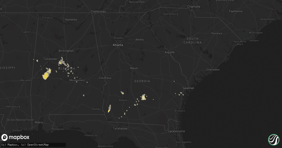
Hail Map in Georgia on July 15, 2015
Get this storm
July 15 map
$229
one time, instant access
Download today. No call, no setup
Keep the $229
Bought the map and want the full workflow? Apply the entire $229 to a subscription within 7 days. None of it is wasted.
Every map, not just this one
This buys you this map. Subscription and you get every map we run, in the markets you choose from a few cities to whole states to nationwide. Plus real-time alerts the moment a storm fires.
Contact data
Name, contact info, occupancy, even credit band for addresses in the footprint. You go from where it hit to who to call.
Become the source they trust
Unlimited branding weather history reports on demand. You already have the documented answer ready for the property owner, and you are the one who showed up with it.
Property data and RoofTrace estimates
Pull up any address you have got, its value and the exact code rules for that jurisdiction, straight from One Click Code. Then RoofTrace estimates the squares, pitch, and roof value, priced the way you price.
Storm reports in Georgia
Georgia
| Date | Description |
|---|---|
| 07/15/20156:45 PM CDT | Tree down in grady county. |
| 07/15/20156:45 PM CDT | Trees down in southern thomas county south of thomasville |
| 07/15/20156:30 PM CDT | Two trees down within the city of thomasville |
| 07/15/20156:30 PM CDT | Several trees down in cairo. |
| 07/15/20155:38 PM CDT | Tree down on wye road. Time estimated by radar. |
| 07/15/20155:38 PM CDT | Tree down on lake drive. Time estimated by radar. |
| 07/15/20155:20 PM CDT | Tree on house on egret circle. Time estimated by radar. |
| 07/15/20155:05 PM CDT | 911 call center received numerous reports of downed trees and power outages around downtown macon. Some locations specifically experiencing the greatest wind damage inc |
| 07/15/20155:05 PM CDT | Atkinson county 911/dispatch reports a tree downed over a road near the intersection of ice plant road and talmadge mckinnon road north of willacoochee. Time of damage |
| 07/15/20155:04 PM CDT | Tree down on john wells rd and hwy 196. Time estimated by radar. |
| 07/15/20154:40 PM CDT | Trees were blown down in the eastern part of the county |
| 07/15/20154:40 PM CDT | Power lines down on the south side of ocilla |
| 07/15/20154:30 PM CDT | Report of either a tree or large branch down on a house in poulan |
| 07/15/20154:15 PM CDT | Tree down near the 3300 block of sylvester road |
| 07/15/20154:13 PM CDT | Trees down at mud road and brooklet-denmark road. Time estimated by radar. |
| 07/15/20154:13 PM CDT | Tree down on highway 90 salem church rd. |
| 07/15/20154:09 PM CDT | Tree down on highway 182. |
| 07/15/20154:00 PM CDT | Coffee county 911/dispatch reported a tree downed over a power line near the intersection of smith street and railroad street in broxton. Time of damage based on radar |
| 07/15/20153:58 PM CDT | Tree down on jones ave. Report relayed via twitter. |
| 07/15/20153:56 PM CDT | Powerline down on a car. Time estimated based on radar. |
| 07/15/20153:56 PM CDT | Tree down and powerlines down on solomon ave. Time estimated based on radar. |
| 07/15/20153:55 PM CDT | Tree down on trailer with people trapped inside. Time estimated by radar. |
| 07/15/20153:45 PM CDT | Tree down on lovers lane road |
| 07/15/20153:30 PM CDT | Peak wind gust of 43 knots. |
| 07/15/20153:20 PM CDT | Power lines down in front of home in 100 block of smith ave. Time estimated from radar |
| 07/14/20158:12 PM CDT | Emergency manager reports approximately 25 trees down west of colquitt with three on homes. Minor structural damage reported to carports and barns in the area. Farmer r |
| 07/14/20158:10 PM CDT | Some trees down in miller county with power outages |
All States Impacted by Hail Map on July 15, 2015
Cities Impacted by Hail Map on July 15, 2015
- Hettinger, ND
- Mayhill, NM
- Auburn, KS
- Topeka, KS
- Colquitt, GA
- New Leipzig, ND
- Mott, ND
- Alexander, ND
- Jamestown, KS
- Blackfoot, ID
- Hoisington, KS
- Maryville, MO
- Glendive, MT
- Bloomfield, MT
- Clyde, MO
- Dawson, NE
- Guilford, MO
- Graham, MO
- Rosendale, MO
- Verdon, NE
- Stanberry, MO
- Skidmore, MO
- Humboldt, NE
- Craig, MO
- Rea, MO
- Ravenwood, MO
- Falls City, NE
- Mound City, MO
- Bolckow, MO
- Hopkins, MO
- Pickering, MO
- Conception, MO
- Conception Junction, MO
- Maitland, MO
- Oregon, MO
- Rulo, NE
- Barnard, MO
- Wyndmere, ND
- Barney, ND
- Springfield, CO
- Forbes, ND
- Ellendale, ND
- Walsh, CO
- Akron, AL
- Greensboro, AL
- Velva, ND
- Sawyer, ND
- Ruso, ND
- Riverton, NE
- Lusk, WY
- Brierfield, AL
- Gorham, KS
- Russell, KS
- Shawnee, WY
- Douglas, WY
- Lost Springs, WY
- Loman, MN
- Otter, MT
- Calico Rock, AR
- West Point, MS
- Union Star, MO
- Everton, AR
- Western Grove, AR
- Harrison, AR
- Green River, UT
- Bladen, NE
- Red Cloud, NE
- Fitzgerald, GA
- Granville, ND
- Pomona, KS
- Dolph, AR
- Norfork, AR
- Pineville, AR
- Houston, MS
- North Carrollton, MS
- Winona, MS
- Carrollton, MS
- McCarley, MS
- Squires, MO
- Ava, MO
- Almont, ND
- Moore, ID
- Watford City, ND
- Arnegard, ND
- Manville, WY
- Benedict, ND
- Voltaire, ND
- Ness City, KS
- Leoti, KS
- Enderlin, ND
- Otis, KS
- Larned, KS
- Cortland, NE
- Firth, NE
- Plymouth, NE
- Pickrell, NE
- Beatrice, NE
- Adams, NE
- De Witt, NE
- Melbourne, AR
- Glen Ullin, ND
- Elgin, ND
- New Salem, ND
- Carson, ND
- Wolverton, MN
- Roscoe, SD
- Alma, NE
- Republican City, NE
- Ensign, KS
- Cimarron, KS
- Mountain Home, AR
- Butte, ND
- Ocilla, GA
- Verbena, AL
- Marbury, AL
- Macon, MS
- Manhattan, KS
- Alma, KS
- Wamego, KS
- Scandia, KS
- Syracuse, NE
- Towner, ND
- Alexander, KS
- White Cloud, KS
- Highland, KS
- Cartwright, ND
- Caputa, SD
- Rapid City, SD
- Ola, AR
- Johnson, KS
- Richfield, KS
- Plattsmouth, NE
- Weeping Water, NE
- Murray, NE
- Nehawka, NE
- Pine Ridge, SD
- Troy, AL
- Lemmon, SD
- Stanton, AL
- Sublette, KS
- Garrison, ND
- Savannah, MO
- King City, MO
- Helena, MO
- Moundville, AL
- Sawyerville, AL
- Livingston, AL
- Linden, AL
- Forkland, AL
- Newbern, AL
- Faunsdale, AL
- Demopolis, AL
- Gallion, AL
- El Dorado Springs, MO
- Grenada, MS
- Oberlin, KS
- Shenandoah, IA
- Garfield, KS
- Williston, ND
- Statesboro, GA
- Brownville, NE
- Bloomington, NE
- Naponee, NE
- Morrowville, KS
- Fairbury, NE
- Cairo, GA
- Unadilla, NE
- Diller, NE
- Palmyra, NE
- Burr, NE
- Elmwood, NE
- Douglas, NE
- Sterling, NE
- Jansen, NE
- Avoca, NE
- Amenia, ND
- Rolla, KS
- Wasola, MO
- Amherst, CO
- Seymour, MO
- Holyoke, CO
- Julesburg, CO
- Montgomery, AL
- Hazen, ND
- Billingsley, AL
- Prattville, AL
- New Market, IA
- Bedford, IA
- Clarinda, IA
- Jemison, AL
- Randolph, AL
- Bessemer, AL
- West Blocton, AL
- Centreville, AL
- Montevallo, AL
- McCalla, AL
- Alabaster, AL
- Helena, AL
- Charleston, MS
- Osceola, MO
- Collins, MO
- Humnoke, AR
- Carlisle, AR
- Wray, GA
- Guide Rock, NE
- Lindsay, MT
- Froid, MT
- Medicine Lake, MT
- Duchesne, UT
- Mapleton, ND
- Elkhart, KS
- Humphrey, AR
- Stuttgart, AR
- Hammond, MT
- Copeland, KS
- Edgemont, SD
- Newcastle, WY
- Wolf Point, MT
- Fort Stockton, TX
- Sand Springs, MT
- Coleharbor, ND
- Thurman, IA
- Tabor, IA
- Half Way, MO
- Pleasant Hope, MO
- Bolivar, MO
- Brighton, MO
- Oxford, MS
- Enid, MS
- Batesville, MS
- Lambert, MS
- Jewell, KS
- Norway, KS
- Selfridge, ND
- Peru, NE
- Helena, AR
- Two Buttes, CO
- Filley, NE
- Crab Orchard, NE
- Deepwater, MO
- Schlater, MS
- Itta Bena, MS
- Victoria, KS
- Natoma, KS
- Plainville, KS
- Nome, ND
- Winona, KS
- Malta, ID
- Brockway, MT
- Aliceville, AL
- Anamoose, ND
- Olmitz, KS
- Marks, MS
- Blue Hill, NE
- Bunker Hill, KS
- Percival, IA
- Glenwood, IA
- Beloit, KS
- Cuba, KS
- Belleville, KS
- Virginia, NE
- Tecumseh, NE
- Marshfield, MO
- Strafford, MO
- Elkland, MO
- Fair Grove, MO
- Buffalo, MO
- Killdeer, ND
- Erie, ND
- Hugoton, KS
- Sykeston, ND
- Woodworth, ND
- Otoe, NE
- Heber Springs, AR
- Rose Bud, AR
- Lance Creek, WY
- Little Rock, AR
- Hanston, KS
- Burdett, KS
- Kinsley, KS
- Rozel, KS
- Montezuma, KS
- Maple Hill, KS
- Paxico, KS
- Gainesville, MO
- Pontiac, MO
- Hoxie, KS
- Midway, GA
- Fleming, GA
- Sumner, GA
- Glen Elder, KS
- Hunter, KS
- Sylvan Grove, KS
- Lucas, KS
- Luray, KS
- Leesburg, GA
- Smithville, GA
- Westboro, MO
- Blanchard, IA
- Great Bend, KS
- Beulah, ND
- Zap, ND
- Litchville, ND
- Lonoke, AR
- Shambaugh, IA
- Wildrose, ND
- Bantry, ND
- Atwood, KS
- Kiron, IA
- Ida Grove, IA
- Wood, SD
- Gassville, AR
- Cohagen, MT
- Louisville, NE
- Talmage, NE
- Nebraska City, NE
- Lowry City, MO
- Maplesville, AL
- Romance, AR
- Hope, NM
- Clarendon, AR
- Waldo, KS
- Manter, KS
- Carbondale, KS
- Tarkio, MO
- Rock Port, MO
- Esmond, ND
- Randolph, MS
- Ayr, NE
- Roseland, NE
- Hector, AR
- Jerusalem, AR
- Mabelvale, AR
- Pierce City, MO
- Monett, MO
- Arco, ID
- Coosada, AL
- Woodland, MS
- Vardaman, MS
- Mantee, MS
- Calhoun City, MS
- Liebenthal, KS
- La Crosse, KS
- Auburn, NE
- Watson, MO
- Fort Yates, ND
- Broomfield, CO
- Gentry, MO
- Albany, MO
- Heartwell, NE
- Kenesaw, NE
- Hays, KS
- Bison, KS
- Pfeifer, KS
- Stanton, ND
- Stella, NE
- Keyes, OK
- Goodwell, OK
- Eutaw, AL
- Boligee, AL
- Washburn, ND
- Vaiden, MS
- Wadena, MN
- Cascilla, MS
- Glendora, MS
- Minter City, MS
- Tutwiler, MS
- Franklin, NE
- Tifton, GA
- Clarkridge, AR
- Nekoma, KS
- Rush Center, KS
- Kismet, KS
- Satanta, KS
- De Valls Bluff, AR
- Edgeley, ND
- Humansville, MO
- Weaubleau, MO
- Tioga, ND
- Elmo, MO
- Burlingame, KS
- Scranton, KS
- Allen, KS
- Osage City, KS
- Reading, KS
- Darlington, MO
- Sebeka, MN
- Terreton, ID
- Shirley, AR
- Clinton, AR
- Des Arc, AR
- Mandaree, ND
- England, AR
- Tucker, AR
- Ellis, KS
- Haxtun, CO
- Damascus, GA
- Donalsonville, GA
- Arlington, GA
- Buffalo, SD
- Rockford, AL
- Clanton, AL
- Thorsby, AL
- Fairview, MT
- Roland, AR
- Thermopolis, WY
- Holstein, NE
- Dilworth, MN
- Moorhead, MN
- Munden, KS
- Hartsfield, GA
- Scott, AR
- North Little Rock, AR
- Carrollton, AL
- Vona, CO
- Mahaska, KS
- Drake, ND
- Raleigh, ND
- Burlington Junction, MO
- Clearmont, MO
- Lewis, KS
- Selden, KS
- West Green, GA
- Beebe, AR
- Kathryn, ND
- Haddam, KS
- Narka, KS
- Albert, KS
- Doerun, GA
- Moultrie, GA
- Shields, ND
- Staples, MN
- Montrose, MO
- Appleton City, MO
- Endicott, NE
- Snowville, UT
- Eskridge, KS
- Mountain View, AR
- Dorrance, KS
- Mount Vernon, AR
- Fargo, ND
- Austin, AR
- Littlefork, MN
- Roe, AR
- Juniata, NE
- Henderson, IA
- Hardaway, AL
- Superior, NE
- Flippin, AR
- Perryville, AR
- Meigs, GA
- Ochlocknee, GA
- Johnson, NE
- Pacific Junction, IA
- Flemington, MO
- Sparta, MO
- Mount Judea, AR
- Kindred, ND
- Christine, ND
- Walcott, ND
- Horace, ND
- Vilas, CO
- Eupora, MS
- Broadus, MT
- Fairfax, MO
- Forest City, MO
- Salem, NE
- Polk, MO
- Wewahitchka, FL
- Branson, MO
- Inavale, NE
- Houlka, MS
- Griffithville, AR
- Overbrook, KS
- Quenemo, KS
- Hinesville, GA
- Wellsville, KS
- Clarksdale, MS
- Junction City, KS
- Gaylord, KS
- Chula, GA
- Lyndon, KS
- Vassar, KS
- Greenwood, MS
- Dalhart, TX
- Saint Anthony, ID
- Millbrook, AL
- Table Rock, NE
- White River, SD
- Whigham, GA
- Vida, MT
- Riceboro, GA
- Deer, AR
- Almyra, AR
- Nemaha, NE
- Ulm, AR
- Yellville, AR
- Fordland, MO
- Reynolds, NE
- Glenvil, NE
- Gamaliel, AR
- Colfax, ND
- Ulysses, KS
- Guion, AR
- Okolona, MS
- Fort Davis, TX
- Terry, MT
- Leeds, ND
- Ottawa, KS
- Perry, FL
- Jal, NM
- Thornfield, MO
- Harveyville, KS
- Gillette, WY
- Myton, UT
- Verndale, MN
- Stratford, TX
- Baldwin City, KS
- Riverton, WY
- Deatsville, AL
- Pillager, MN
- Farragut, IA
- Coin, IA
- Elaine, AR
- Steele City, NE
- Hollenberg, KS
- Trenton, ND
- Hastings, IA
- Emerson, IA
- Brooksville, MS
- Underwood, ND
- Big Falls, MN
- Mound City, SD
- Churchs Ferry, ND
- Maben, MS
- Belvue, KS
- McFarland, KS
- Saint George, KS
- Pritchett, CO
- Kim, CO
- Ewing, NE
- Judsonia, AR
- Orleans, NE
- Ayr, ND
- Motley, MN
- Marion, AL
- Olathe, KS
- Grady, AR
- Calera, AL
- Cotton Plant, AR
- El Paso, AR
- Searcy, AR
- Dodge City, KS
- Sidney, MT
- Selma, AL
- Sidney, IA
- Calhan, CO
- Parker, ID
- Granada, CO


