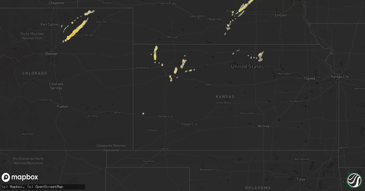
Hail Map on July 15, 2011
Get this storm
July 15 map
$229
one time, instant access
Download today. No call, no setup
Keep the $229
Bought the map and want the full workflow? Apply the entire $229 to a subscription within 7 days. None of it is wasted.
Every map, not just this one
This buys you this map. Subscription and you get every map we run, in the markets you choose from a few cities to whole states to nationwide. Plus real-time alerts the moment a storm fires.
Contact data
Name, contact info, occupancy, even credit band for addresses in the footprint. You go from where it hit to who to call.
Become the source they trust
Unlimited branding weather history reports on demand. You already have the documented answer ready for the property owner, and you are the one who showed up with it.
Property data and RoofTrace estimates
Pull up any address you have got, its value and the exact code rules for that jurisdiction, straight from One Click Code. Then RoofTrace estimates the squares, pitch, and roof value, priced the way you price.
States Impacted by Hail Map on July 15, 2011
Storm reports
Minnesota
| Date | Description |
|---|---|
| 07/15/20114:50 PM CDT | Also 1.25 inches of rain |
| 07/15/20114:28 PM CDT | Some flattened corn near waltham. |
| 07/15/20113:30 PM CDT | Wind e 50 mph power lines down also flash flooding |
| 07/15/20112:59 PM CDT | Tree down on a roof of trailer |
| 07/15/20112:00 PM CDT | A local report indicates 70 MPH wind near 1 E MOUNTAIN LAKE |
| 07/15/20111:15 PM CDT | Estimate 50 mph 3 to 4 inch tree limbs down |
| 07/15/201112:40 PM CDT | Tree damage...6 to 8 inch limbs. |
| 07/15/20118:45 AM CDT | County emergency manager reports a home under construction along 300th st suffered damage along with several uprooted trees. |
| 07/15/20117:25 AM CDT | A local report indicates 1.00 inch wind near 3 N HERMAN |
| 07/15/20117:13 AM CDT | A local report indicates 1.00 inch wind near 1 N BARRETT |
Iowa
| Date | Description |
|---|---|
| 07/15/20111:35 AM CDT | A local report indicates 62 MPH wind near ATLANTIC AIRPORT |
| 07/15/20111:20 AM CDT | Several trees uprooted. A couple of barns destroyed. Corn flattened. |
Colorado
| Date | Description |
|---|---|
| 07/15/201112:13 AM CDT | Anemometer fell over when wind speed reached 68.3 mph. 3000 gallon poly tank which weighs 700 lbs was blown a distance of one mile |
Kansas
| Date | Description |
|---|---|
| 07/15/20115:52 PM CDT | Estimated 0.5 inches of rain in 10 minutes. |
| 07/14/20119:20 PM CDT | A local report indicates 1.00 inch wind near 10 N BEARDSLEY |
| 07/14/20118:22 PM CDT | Irrigation pivot reported overturned along with tree limbs down across clyde. |
| 07/14/20118:20 PM CDT | A local report indicates 1.25 inch wind near 10 S BEARDSLEY |
| 07/14/20118:05 PM CDT | A local report indicates 60 MPH wind near 1 WNW AGENDA |
| 07/14/20118:05 PM CDT | 4 to 5 inch diameter tree limb down. |
| 07/14/20117:50 PM CDT | A local report indicates 60 MPH wind near 9 SSE BELLEVILLE |
| 07/14/20117:49 PM CDT | A local report indicates 67 MPH wind near CONCORDIA |
Nebraska
| Date | Description |
|---|---|
| 07/15/20116:50 PM CDT | A local report indicates 60 MPH wind near ROSELAND |
| 07/15/20116:50 PM CDT | Relayed from khas tv...grain elevator leg/shaft collapsed and a tree was completely uprooted in town. |
| 07/14/20119:56 PM CDT | Power lines down and 6 inch diameter tree branches down |
| 07/14/20119:40 PM CDT | Estimated 60 mph winds in town |
| 07/14/20118:20 PM CDT | Uprooted trees in cemetery near highway 281 and stolley park road. Time estimated from radar data. |
Idaho
| Date | Description |
|---|---|
| 07/15/20116:51 PM CDT | Measured at kriley creek raws at 5200 feet. |
Georgia
| Date | Description |
|---|---|
| 07/15/20111:05 PM CDT | Tin roof on two chicken houses removed. One large oak tree also knocked down. |
Florida
| Date | Description |
|---|---|
| 07/15/20113:38 PM CDT | Large tree limbs down. Time estimated by radar. |
| 07/15/20113:10 PM CDT | Quarter sized hail reported by orlando media near the intersection of highways 408 and 436. |
| 07/15/20111:03 PM CDT | Trees down along state highway 121. |
| 07/15/20111:00 PM CDT | The sheriffs office reported trees and powerlines down in and near the jasper city limits. The time given was based on radar. |
| 07/15/20111:00 PM CDT | The sheriffs office reported trees and powerlines down in the jasper city limits. Time given was based on radar. |
| 07/15/201112:27 PM CDT | Trees down along county road 53 |
| 07/15/201112:17 PM CDT | Powerlines down |
| 07/15/201112:17 PM CDT | Powerlines down |
| 07/15/201112:16 PM CDT | Trees down near greenville |
North Dakota
| Date | Description |
|---|---|
| 07/15/20111:59 AM CDT | A local report indicates 58 MPH wind near 8 E ROSEGLEN |
| 07/15/20111:20 AM CDT | Two and a half foot diameter tree at the high school was broken off. Tree was approximately 30 feet tall. |
| 07/15/20111:20 AM CDT | A local report indicates 62 MPH wind near STANLEY |
| 07/14/201111:10 PM CDT | Late report from coop trees down 15 north of trotters |
Montana
| Date | Description |
|---|---|
| 07/14/201111:45 PM CDT | Several trees reported blown over across highway 16 about 6 to 8 miles south of savage. Trees are blocking traffic. |
| 07/14/201111:45 PM CDT | A local report indicates 1.00 inch wind near SAVAGE |
| 07/14/201111:45 PM CDT | Winds measured in excess of 60 mph. Several large trees are down in town. Some of the tree diameters were at least two feet wide. |
| 07/14/201111:10 PM CDT | A local report indicates 65 MPH wind near 2 ESE GEYSER |
| 07/14/201111:08 PM CDT | A local report indicates 68 MPH wind near GLENDIVE |
| 07/14/20117:18 PM CDT | Dime size hail and about 1 inch of rain. |
| 07/14/20117:10 PM CDT | Few quarters...mostly pea to penny size hail |
Cities Impacted by Hail Map on July 15, 2011
- Melrose, MN
- Zap, ND
- Beulah, ND
- Keenesburg, CO
- Golden Valley, ND
- Malta, MT
- Killdeer, ND
- Mandaree, ND
- Winthrop, MN
- Waseca, MN
- New Richland, MN
- Waldorf, MN
- Walnut, IA
- Cartwright, ND
- Alexander, ND
- Arnegard, ND
- Watford City, ND
- Wheaton, MN
- Northwood, IA
- Kensett, IA
- Glenville, MN
- Grafton, IA
- Emmons, MN
- Manly, IA
- Grinnell, KS
- Juniata, NE
- Roseland, NE
- Holstein, NE
- Kenesaw, NE
- Savage, MT
- Lindsay, MT
- Terry, MT
- Albany, MN
- Bloomfield, MT
- Wells, MN
- Bricelyn, MN
- Circle, MT
- Brockway, MT
- Paynesville, MN
- Mapleton, MN
- Amboy, MN
- Winter Springs, FL
- Oviedo, FL
- Stoneham, CO
- Saint Cloud, FL
- Stanley, ND
- Villard, MN
- Glenwood, MN
- Plainfield, IA
- Nashua, IA
- Greeley, CO
- Eaton, CO
- Richmond, MN
- Orchard, CO
- Wiggins, CO
- Fort Morgan, CO
- New Raymer, CO
- Weldona, CO
- Roggen, CO
- Cold Spring, MN
- Eden Valley, MN
- Watkins, MN
- Avon, MN
- Saint Martin, MN
- Freeport, MN
- Saint Joseph, MN
- Roscoe, MN
- Cleveland, MN
- Le Center, MN
- Le Sueur, MN
- Monroe, NE
- Platte Center, NE
- Columbus, NE
- Musselshell, MT
- Glendive, MT
- Brooten, MN
- Sauk Centre, MN
- Ocala, FL
- Anthony, FL
- Williston, ND
- Ute, IA
- Gaylord, MN
- Avoca, IA
- Belgrade, MN
- Lavina, MT
- Shelby, IA
- Hoxie, KS
- Roundup, MT
- Ryegate, MT
- Pemberton, MN
- Halliday, ND
- Duncan, NE
- Hordville, NE
- Clarks, NE
- Silver Creek, NE
- Polk, NE
- Osceola, NE
- Tioga, ND
- Ray, ND
- White Earth, ND
- Boston, GA
- Cohagen, MT
- Good Thunder, MN
- McDonald, KS
- Colby, KS
- Burtrum, MN
- Grey Eagle, MN
- Herman, MN
- Winnett, MT
- Silver Lake, MN
- Logan, IA
- Woodbine, IA
- Geneva, FL
- Alexandria, MN
- Osakis, MN
- Kersey, CO
- Gill, CO
- Rapelje, MT
- Broadview, MT
- Sac City, IA
- Schuyler, NE
- Lambert, MT
- Shepherd, MT
- Hoffman, MN
- Kensington, MN
- Jamestown, KS
- Concordia, KS
- Panama, IA
- Harlan, IA
- Portsmouth, IA
- Earling, IA
- Intercession City, FL
- Kissimmee, FL
- Mankato, KS
- Atwater, MN
- Orlando, FL
- Sanford, FL
- Marne, IA
- Atlantic, IA
- Saint Cloud, MN
- Rockville, MN
- Kimball, MN
- Persia, IA
- Diboll, TX
- Ingomar, MT
- Elbow Lake, MN
- Barrett, MN
- Lake Placid, FL
- Hill City, KS
- Penokee, KS
- Grassy Butte, ND
- Agenda, KS
- Ross, ND
- Saint James, MN
- Chapman, NE
- Aurora, NE
- Marquette, NE
- Grand Island, NE
- Central City, NE
- Phillips, NE
- Howells, NE
- Scribner, NE
- Belle Plaine, MN
- Henderson, MN
- Selden, KS
- Dodge, NE
- Debary, FL
- Eustis, FL
- Farmington, MN
- Elko New Market, MN
- Prior Lake, MN
- Webster, MN
- Lakeville, MN
- Northfield, MN
- Onawa, IA
- Dixie, GA
- Levant, KS
- Atwood, KS
- Genoa, NE
- Zumbrota, MN
- Wanamingo, MN
- Goodhue, MN
- Green Cove Springs, FL
- Palatka, FL
- Plato, MN
- Lester Prairie, MN
- Young America, MN
- Arlington, MN
- Farwell, MN
- Donnelly, MN
- Morris, MN
- Morland, KS
- Acton, MT
- Blencoe, IA
- Wibaux, MT
- Grainfield, KS
- Glencoe, MN
- Hutchinson, MN
- Alda, NE
- Starbuck, MN
- Blue Earth, MN
- Brandon, MN
- Evansville, MN
- Garfield, MN
- Holdingford, MN
- Hartland, MN
- Epping, ND
- Litchfield, MN
- Darwin, MN
- Westphalia, IA
- Briggsdale, CO
- Easton, MN
- Decatur, NE
- Minnesota Lake, MN
- Randolph, MN
- Hampton, MN
- Humphrey, NE
- Jennings, KS
- Florahome, FL
- Keystone Heights, FL
- Minden, IA
- Alden, MN
- Albert Lea, MN
- Hamburg, MN
- Lakeland, FL
- Ellendale, MN
- Owatonna, MN
- Mankato, MN
- Craig, NE
- Tekamah, NE
- Lyons, NE
- Oakland, NE
- Truman, MN
- Castana, IA
- West Point, NE
- Janesville, MN
- Richey, MT
- Apple Springs, TX
- Lowry, MN
- North Bend, NE
- Clarkson, NE
- Rogers, NE
- Christmas, FL
- Belleville, KS
- Clyde, KS
- Cuba, KS
- Haddam, KS
- South Haven, MN
- Kandiyohi, MN
- Willmar, MN
- Spicer, MN
- Doniphan, NE
- Mulberry, FL
- Norway, KS
- Hastings, NE
- Plant City, FL
- Carroll, IA
- Campbell, NE
- Riverton, NE
- Okeechobee, FL
- Dunn Center, ND
- Billings, MT
- Keene, ND
- Forsyth, MT
- Hancock, IA
- Oakland, IA
- Stewart, MN
- Ormsby, MN
- Trimont, MN
- Esbon, KS
- Nelson, MN
- Carlos, MN
- Kiester, MN
- Giltner, NE
- Dumont, MN
- Graceville, MN
- Missouri Valley, IA
- Pisgah, IA
- Mondamin, IA
- Soldier, IA
- Lake Lillian, MN
- New Town, ND
- Blooming Prairie, MN
- Lake Mills, IA
- Padroni, CO
- Worden, MT
- Custer, MT
- Winter Park, FL
- Dunlap, IA
- Frost, MN
- Hysham, MT
- Elmore, MN