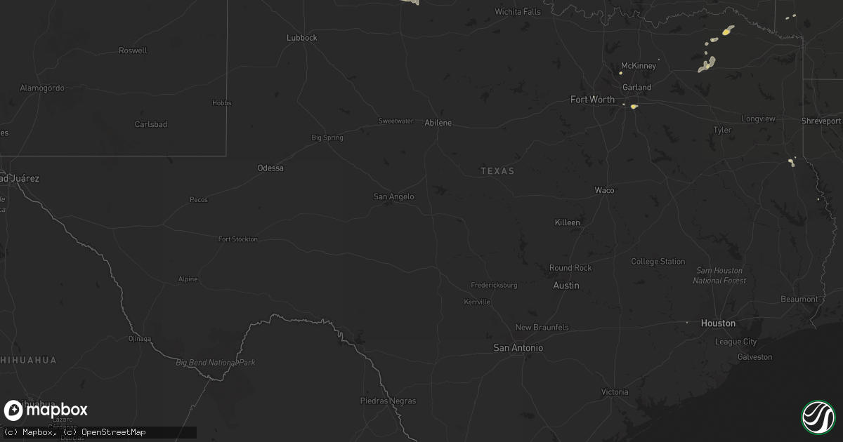
Hail Map in Texas on July 14, 2014
Get this storm
July 14 map
$229
one time, instant access
Download today. No call, no setup
Keep the $229
Bought the map and want the full workflow? Apply the entire $229 to a subscription within 7 days. None of it is wasted.
Every map, not just this one
This buys you this map. Subscription and you get every map we run, in the markets you choose from a few cities to whole states to nationwide. Plus real-time alerts the moment a storm fires.
Contact data
Name, contact info, occupancy, even credit band for addresses in the footprint. You go from where it hit to who to call.
Become the source they trust
Unlimited branding weather history reports on demand. You already have the documented answer ready for the property owner, and you are the one who showed up with it.
Property data and RoofTrace estimates
Pull up any address you have got, its value and the exact code rules for that jurisdiction, straight from One Click Code. Then RoofTrace estimates the squares, pitch, and roof value, priced the way you price.
Storm reports in Texas
Texas
| Date | Description |
|---|---|
| 07/14/20146:57 PM CDT | A mix of pea to quarter size hail was falling along with very heavy rain and street flooding near 45th and soncy. |
| 07/14/20146:32 PM CDT | 65 mph wind gust measured in seagoville. Large tree limbs damaged. Hail lasted for approximately 8 minutes. |
| 07/14/20145:52 PM CDT | Via kvii schoolnet at middlewell methodist church. |
| 07/14/20145:43 PM CDT | Trees blown down roughly at the intersection of northern cross and anderson boulevard. |
| 07/14/20145:15 PM CDT | A local report indicates 58 MPH wind near 3 SW DALHART |
| 07/14/20145:08 PM CDT | A local report indicates 58 MPH wind near 3 SW DALHART |
| 07/14/20144:58 PM CDT | Several trees damaged along highway 11 near como. |
| 07/14/20144:49 PM CDT | Trees damaged in the oak cliff section of the city of dallas |
| 07/14/20144:30 PM CDT | Wind damage to grain elevator and silo. |
| 07/14/20144:29 PM CDT | Pea to marble size hail was also falling. |
| 07/14/20143:15 PM CDT | Large trees damaged by thunderstorm winds near the colony |
| 07/14/20143:10 PM CDT | Wind damage in frisco. House under construction destroyed |
| 07/14/20142:55 PM CDT | Tree down over road on cr 2104 |
| 07/14/20142:55 PM CDT | Large limbs down up and down fm 2573 in bagwell |
| 07/13/20147:50 PM CDT | A local report indicates 61 MPH wind near 11 WNW BOOTLEG |
| 07/13/20147:04 PM CDT | Hail up to quarter size fell in the hillside terrace neighborhood. |
All States Impacted by Hail Map on July 14, 2014
Cities Impacted by Hail Map on July 14, 2014
- Peyton, CO
- Dalhart, TX
- Hartley, TX
- Galeton, CO
- Ault, CO
- Pierce, CO
- Briggsdale, CO
- Anadarko, OK
- Ririe, ID
- Iona, ID
- Manter, KS
- Johnson, KS
- Elkhart, KS
- Syracuse, KS
- Cedar Vale, KS
- Tulia, TX
- Kress, TX
- California, MO
- Clarksburg, MO
- Sharon, TN
- Channing, TX
- Pratt, KS
- Hernando, FL
- Avondale, CO
- Gates, TN
- Brownsville, TN
- Hart, TX
- Silverton, TX
- Paris, TX
- Mena, AR
- Deer, AR
- Clinton, AR
- Felt, OK
- Paducah, TX
- Sardis, TN
- Reagan, TN
- Enville, TN
- La Jara, NM
- Regina, NM
- Colorado Springs, CO
- Kingman, AZ
- Tipton, MO
- Claude, TX
- Groom, TX
- Kingston, AR
- Ponca, AR
- Hugoton, KS
- Moriarty, NM
- Lamar, CO
- Firth, ID
- Leslie, AR
- Marshall, AR
- Witts Springs, AR
- Dennard, AR
- Pelsor, AR
- Mount Judea, AR
- Adair, OK
- Pryor, OK
- Summit, UT
- Panguitch, UT
- Pierson, FL
- Adamsville, TN
- Bethel Springs, TN
- Carnegie, OK
- Mountain View, OK
- Cordell, OK
- Bondurant, WY
- Queen Anne, MD
- Centreville, MD
- Greenfield, TN
- Bradford, TN
- McKenzie, TN
- Star City, AR
- Hereford, TX
- Moscow, TN
- Stinnett, TX
- Callao, VA
- Kinsale, VA
- Hague, VA
- Texline, TX
- Lawton, OK
- Cisco, IL
- Milmine, IL
- Cerro Gordo, IL
- Argenta, IL
- Karval, CO
- Ordway, CO
- Yoder, CO
- Rush, CO
- Blackfoot, ID
- Pueblo, CO
- Everest, KS
- Hiawatha, KS
- Bellvue, CO
- Sturgeon Bay, WI
- Atchison, KS
- Bendena, KS
- Nashville, KS
- Isabel, KS
- Groveland, FL
- Clermont, FL
- Dike, TX
- Minneola, KS
- Protection, KS
- Childress, TX
- Memphis, TX
- Buena Vista, CO
- Boise City, OK
- Owings Mills, MD
- Elfrida, AZ
- South Haven, KS
- Geuda Springs, KS
- Meade, KS
- Fowler, KS
- Newport, AR
- Tuckerman, AR
- Amarillo, TX
- Swan Valley, ID
- Tucson, AZ
- Quitaque, TX
- Witter, AR
- Huntsville, AR
- Brighton, TN
- Covington, TN
- Dermott, AR
- Tenaha, TX
- Edwall, WA
- Frisco, TX
- The Colony, TX
- Russellville, MO
- Calhan, CO
- Walsenburg, CO
- Olney Springs, CO
- Wheeler, TX
- Briscoe, TX
- Shamrock, TX
- Mobeetie, TX
- Jackson, WY
- Ripley, TN
- Halls, TN
- Somerville, TN
- Concordia, MO
- Canyon, TX
- Huntingdon, TN
- Hollow Rock, TN
- Bruceton, TN
- Medicine Lodge, KS
- Judsonia, AR
- Jackson, TN
- Kenton, TN
- Trumann, AR
- Lake City, AR
- Collegeville, PA
- Blue Bell, PA
- North Wales, PA
- Ambler, PA
- Gwynedd, PA
- Lansdale, PA
- Norristown, PA
- Elkins, AR
- Bourbonnais, IL
- Cuba, NM
- Holladay, TN
- Stanton, TN
- Lakewood, NJ
- Jackson, NJ
- Locust Grove, AR
- De Leon Springs, FL
- Hasty, CO
- Middleburg, FL
- Mason, TN
- Pagosa Springs, CO
- Malta, ID
- Hereford, AZ
- Guymon, OK
- Pinson, TN
- Saint Cloud, FL
- Beech Bluff, TN
- Deltona, FL
- Taylors Island, MD
- Grand Junction, TN
- Crossett, AR
- Shirley, AR
- Fox, AR
- Dallas, TX
- Hutchins, TX
- Medina, TN
- Oakfield, TN
- Montezuma, KS
- Mount Vernon, KY
- Chelsea, OK
- Hobart, OK
- Hughesville, MO
- Houstonia, MO
- Sweet Springs, MO
- La Monte, MO
- Lockesburg, AR
- Watson, AR
- Bee Branch, AR
- Yuma, TN
- Campo, CO
- Trezevant, TN
- Danville, IL
- Parsons, TN
- Linn, MO
- Hagarville, AR
- Lavaca, AR
- Huntington, UT
- Sulphur Springs, TX
- Holly, CO
- Grace, ID
- Bancroft, ID
- Greenwood, AR
- Long Barn, CA
- Happy, TX
- Lenox, TN
- Dyersburg, TN
- Loveland, CO
- Fort Collins, CO
- Longmont, CO
- Atwood, TN
- Milan, TN
- Moore, ID
- Worley, ID
- Wiley, CO
- McClave, CO
- Boone, CO
- Queenstown, MD
- Finley, TN
- Wilmer, TX
- Alamo, TN
- Gadsden, TN
- Humboldt, TN
- Zwolle, LA
- Many, LA
- Damascus, AR
- Boles, AR
- Hickory Valley, TN
- Bolivar, TN
- Daniel, WY
- Chestertown, MD
- Penfield, IL
- Gleason, TN
- Clarendon, TX
- Latham, MO
- Clarksville, TX
- Detroit, TX
- Champaign, IL
- Urbana, IL
- Cotopaxi, CO
- Matador, TX
- Loose Creek, MO
- Friendship, TN
- La Junta, CO
- Memphis, TN
- Whiteville, TN
- Berea, KY
- McKee, KY
- Parowan, UT
- Paragonah, UT
- Jacks Creek, TN
- Henderson, TN
- Huron, TN
- Drasco, AR
- Concord, AR
- Tumbling Shoals, AR
- Ida, AR
- Lascassas, TN
- Tillar, AR
- Woodland Park, CO
- Vanleer, TN
- Erin, TN
- Bay, AR
- Jonesboro, AR
- Marshall, VA
- Oakland, TN
- Brooksville, FL
- Dillwyn, VA
- Mercer, TN
- Old Monroe, MO
- Mansfield, TN
- Wilmar, AR
- Rison, AR
- Hatfield, AR
- Castlewood, VA
- Mccurtain, OK
- Goodwell, OK
- Arlington, TN
- Hazen, AR
- Berthoud, CO
- Deland, FL
- Lake Helen, FL
- Drake, CO
- Montpelier, ID
- Erie, CO
- Springfield, CO
- Grady, NM
- Rutherford, TN
- Waynesburg, KY
- Stanford, KY
- Haviland, KS
- Higginsville, MO
- Little Rock, AR
- Alexander, AR
- Marshall, MO
- Nelson, MO
- Westcliffe, CO
- Darden, TN
- Summerville, GA
- Sedan, NM
- Monette, AR
- Charleston, AR
- Huger, SC
- Animas, NM
- Monticello, AR
- Stewart, TN
- Bradley, OK
- Rush Springs, OK
- Meherrin, VA
- Potomac, IL
- Otterville, MO
- Syracuse, MO
- Florence, MO
- Sedalia, MO
- Smithton, MO
- Bunceton, MO
- Pilot Grove, MO
- Cordova, MD
- Clayton, NM
- Tichnor, AR
- Fort Smith, AR
- Cumberland, VA
- Mead, CO
- Medon, TN
- Toone, TN
- Hemphill, TX
- Irvine, KY
- Waco, KY
- Celeste, TX
- Farmersville, TX
- Howell, NJ
- Scottsdale, AZ
- Grouse Creek, UT
- Astor, FL
- Elkton, FL
- Wickes, AR
- Savannah, TN
- Ninnekah, OK
- Grenville, NM
- Saint Maries, ID
- Henry, TN
- Batesville, AR
- Clarksdale, MS
- Jackson, NC
- Pattonville, TX
- Somerset, KY
- Wellington, KS
- Philipsburg, MT
- Warrenton, MO
- Trenton, TN
- Bastrop, LA
- Jerusalem, AR
- Hornersville, MO
- Sun City, KS
- Leachville, AR
- Byers, KS
- Ravenna, KY
- Salida, CO
- Blanding, UT
- Gilbert, LA
- Quitman, AR
- Sparta, TN
- Bonfield, IL
- Wilmington, IL
- Essex, IL
- Center, TX
- Joaquin, TX
- Jacksonville, FL
- Twin Falls, ID
- Denton, KS
- Leedey, OK
- Mountain View, AR
- Newkirk, OK
- Paris, TN
- Parks, AR
- Trinidad, CO
- Pleasant Grove, AR
- Towson, MD
- El Dorado, KS
- Brookland, AR
- Bement, IL
- Fort Garland, CO
- Crowell, TX
- Winslow, AR
- Weldon, NC
- Paragould, AR
- New Egypt, NJ
- Caraway, AR
- Manila, AR
- Elsah, IL
- Dow, IL
- Pettigrew, AR
- Arbyrd, MO
- Cardwell, MO
- Big Sandy, TN
- Mechanicsville, MD
- Binger, OK
- Cave Creek, AZ
- Henning, TN
- Bagwell, TX
- Clinton, IL
- Crab Orchard, KY
- Black Oak, AR
- Rossville, TN
- Hastings, FL
- Finger, TN
- Romance, AR
- Nathrop, CO
- Ensign, KS
- Saint Paul, AR
- Oark, AR
- Hartford, IL
- Driggs, ID
- Panhandle, TX
- Cumberland City, TN
- Lexington, TN
- Ocala, FL
- Hermitage, AR
- Wildersville, TN
- Lyon, MS
- Trenton, FL
- Saint Michaels, MD
- Royal Oak, MD
- Macksville, KS
- Lavinia, TN
- Saint Joseph, IL
- Thomasboro, IL
- Rupert, ID
- Warsaw, VA
- Big Cabin, OK
- Albion, ID
- Springville, TN
- Montgomeryville, PA
- Phoenixville, PA
- Horsham, PA
- Liberty, TN
- Tolono, IL
- Sierra Vista, AZ
- Inverness, FL
- Vendor, AR
- Martin, TN
- Dresden, TN
- Ashdown, AR
- Antimony, UT
- Gracemont, OK
- Baker, LA
- Zachary, LA
- Green Cove Springs, FL
- Saint Leonard, MD
- Port Republic, MD
- Crossville, AL
- Lindsay, OK
- Camden, TN
- Bushnell, FL
- Floral City, FL
- Dierks, AR
- De Queen, AR
- Mayhill, NM
- Pangburn, AR
- Athens, TN
- Weirsdale, FL
- Appomattox, VA
- Globe, AZ
- Ozark, AR
- Ratcliff, AR
- Las Animas, CO
- Christmas, FL
- Orlando, FL
- Bunnell, FL
- Saulsbury, TN
- Kankakee, IL
- Fort McCoy, FL
- Oviedo, FL
- Bronson, FL
- Cedar Grove, TN
- Altus, AR
- Scranton, AR
- Paris, AR
- Coal Hill, AR
- Lohman, MO
- Jefferson City, MO
- Huachuca City, AZ
- Fort Worth, TX
- Deport, TX
- Fountain Hill, AR
- Drummonds, TN
- Burlison, TN
- Oil Trough, AR
- Dowelltown, TN
- Weldon, IL
- Lady Lake, FL
- The Villages, FL
- Murfreesboro, TN
- Milton, TN
- Counselor, NM
- Osceola, AR
- Lepanto, AR
- Chester, NJ
- Long Valley, NJ
- Maroa, IL
- Eubank, KY
- Rose Bud, AR
- Elgin, OK
- Irwin, ID
- Cecil, AR
- Tappahannock, VA
- Easton, MD
- Saint Augustine, FL
- Blytheville, AR
- Dubois, WY
- Alligator, MS
- Lutherville Timonium, MD
- Stevenson, MD
- McClure, IL
- Attalla, AL
- Gadsden, AL
- Richfield, KS
- Beaverville, IL
- Union City, TN
- Winter Garden, FL
- Hot Springs National Park, AR
- Floral, AR
- Noble, LA
- Ashland, MS
- Michigan City, MS
- Stanton, KY
- Katy, TX
- Denmark, TN
- Combs, AR
- Cove, AR
- Idaho Falls, ID
- American Falls, ID
- Collierville, TN
- Amistad, NM
- Laporte, CO
- Warrenton, VA
- Ganado, AZ
- Saint Johns, FL
- Pleasant Plains, AR
- S Coffeyville, OK
- Hornsby, TN
- Reisterstown, MD
- Copeland, KS


