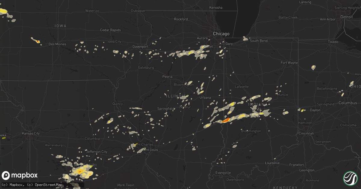
Hail Map in Illinois on July 13, 2016
Get this storm
July 13 map
$229
one time, instant access
Download today. No call, no setup
Keep the $229
Bought the map and want the full workflow? Apply the entire $229 to a subscription within 7 days. None of it is wasted.
Every map, not just this one
This buys you this map. Subscription and you get every map we run, in the markets you choose from a few cities to whole states to nationwide. Plus real-time alerts the moment a storm fires.
Contact data
Name, contact info, occupancy, even credit band for addresses in the footprint. You go from where it hit to who to call.
Become the source they trust
Unlimited branding weather history reports on demand. You already have the documented answer ready for the property owner, and you are the one who showed up with it.
Property data and RoofTrace estimates
Pull up any address you have got, its value and the exact code rules for that jurisdiction, straight from One Click Code. Then RoofTrace estimates the squares, pitch, and roof value, priced the way you price.
Storm reports in Illinois
Illinois
| Date | Description |
|---|---|
| 07/13/20166:58 PM CDT | Tree fell on ashbrook lane covering most of the street. |
| 07/13/20166:45 PM CDT | A local report indicates 60 MPH wind near BOURBONNAIS |
| 07/13/20166:41 PM CDT | A local report indicates 65 MPH wind near 4 SW SHOREWOOD |
| 07/13/20166:41 PM CDT | Mature trees were bending. |
| 07/13/20166:37 PM CDT | Trees up to 1.5 feet in diameter down. One tree blocking route 1. |
| 07/13/20166:36 PM CDT | A local report indicates 60 MPH wind near 5 SE YORKVILLE |
| 07/13/20166:34 PM CDT | Stoplight damaged at illinois route 1 and 17. |
| 07/13/20166:30 PM CDT | Across central and southern kankakee county. Over 200 trees and powerlines down. |
| 07/13/20166:27 PM CDT | Near the library. Also pea size hail. |
| 07/13/20166:22 PM CDT | Large tree downed onto car and home. Time estimated from radar. |
| 07/13/20166:15 PM CDT | Power poles and power lines down on south henning road just south of us hwy 150 |
| 07/13/20166:15 PM CDT | Power poles and power lines down on south henning road just south of us hwy 150 |
| 07/13/20166:15 PM CDT | A local report indicates 65 MPH wind near 3 NE NEWARK |
| 07/13/20166:05 PM CDT | Large tree downed. Time estimated by radar. |
| 07/13/20166:01 PM CDT | A local report indicates 58 MPH wind near 3 E ROBINSON |
| 07/13/20166:00 PM CDT | A local report indicates 62 MPH wind near 1 W MILLINGTON |
| 07/13/20166:00 PM CDT | Measured by u.s. Army corp of engineers sensor. |
| 07/13/20166:00 PM CDT | 10 inch diameter tree down on carport. |
| 07/13/20166:00 PM CDT | A 50 foot tall poplar tree... 12 to 15 foot in diameter uprooted on heritage drive at heritage lake... One mile east of mackinaw. Numerous trees snapped or uprooted els |
| 07/13/20166:00 PM CDT | Intersection of boyce memeorial drive and ottawa avenue. |
| 07/13/20165:57 PM CDT | Couple large trees down in and near town. Time estimated from radar. |
| 07/13/20165:56 PM CDT | Large tree limb down at philo and old church roads. |
| 07/13/20165:55 PM CDT | Tv antenna tower blown down. Roof shingles blown off building. Small to medium sized tree limbs blown down |
| 07/13/20165:55 PM CDT | Several trees and large limbs down |
| 07/13/20165:55 PM CDT | A local report indicates 78 MPH wind near S URBANA |
| 07/13/20165:52 PM CDT | Tree limbs down across city. Largest is 2 feet in diameter. Average is 8 inches in diameter. |
| 07/13/20165:52 PM CDT | Also 4-5 inch tree limbs down. |
| 07/13/20165:50 PM CDT | Large tree snapped and fell to ground. No damage reported. |
| 07/13/20165:45 PM CDT | Tree down on house. |
| 07/13/20165:45 PM CDT | Large tree down in town |
| 07/13/20165:45 PM CDT | Large oak tree uprooted...crossing summit ave north between main and william |
| 07/13/20165:40 PM CDT | Shingles off of a home. |
| 07/13/20165:40 PM CDT | Numerous large tree branches blown down in olney city park. |
| 07/13/20165:39 PM CDT | Metal roof peeled off grandstand at richland county fair grounds. |
| 07/13/20165:38 PM CDT | Numerous trees down on power lines at 1000n/county road 220...trees across the road |
| 07/13/20165:35 PM CDT | Large tree branches down in town. |
| 07/13/20165:35 PM CDT | A local report indicates 60 MPH wind near CROSSVILLE |
| 07/13/20165:32 PM CDT | Numerous trees down in town between west butler street and west st. John street. Tree down on locust street. |
| 07/13/20165:32 PM CDT | A local report indicates 65 MPH wind near OLNEY |
| 07/13/20165:30 PM CDT | Tree limbs fell on truck. |
| 07/13/20165:30 PM CDT | Tree blown onto garage on 22nd street. Several trees and tree branches down on western ave. |
| 07/13/20165:30 PM CDT | A local report indicates 60 MPH wind near MATTOON |
| 07/13/20165:30 PM CDT | Across central and southern kankakee county. Over 200 trees and powerlines down. |
| 07/13/20165:28 PM CDT | Large tree branch down |
| 07/13/20165:25 PM CDT | Small limbs down |
| 07/13/20165:19 PM CDT | Tree blown down in town. |
| 07/13/20165:18 PM CDT | Tree fell on house and went through roof |
| 07/13/20165:16 PM CDT | Large tree down 1000 block of illinois ave. |
| 07/13/20165:15 PM CDT | Multiple trees down in town |
| 07/13/20165:15 PM CDT | Large tree limbs/branches down |
| 07/13/20165:15 PM CDT | Mobile home rolled and distroyed...person inside was taken to hospital. Grain bin blown 200 feet |
| 07/13/20165:14 PM CDT | A local report indicates 63 MPH wind near PERU |
| 07/13/20165:12 PM CDT | Several houses with roof damage near high school. |
| 07/13/20165:09 PM CDT | Roof off of downtown building. Numerous trees and tree limbs down. Two homes damaged by falling branches. |
| 07/13/20165:09 PM CDT | Trees blown down...some buildings damaged. |
| 07/13/20165:06 PM CDT | Trees and power poles down near town...time estimated from radar. |
| 07/13/20165:03 PM CDT | Large tree limbs down. |
| 07/13/20165:02 PM CDT | Tree snapped at base and landed on garage. Relayed through wsil channel 3. |
| 07/13/20165:00 PM CDT | Large tree branches down in town |
| 07/13/20164:58 PM CDT | Large tree limbs down and top of tree broken off. |
| 07/13/20164:58 PM CDT | Tree uprooted on north summit ave. Obtained from social media. |
| 07/13/20164:58 PM CDT | Trees and power lines down |
| 07/13/20164:58 PM CDT | Large tree uprooted and landed on a house in town. |
| 07/13/20164:56 PM CDT | Trees and powr lines down |
| 07/13/20164:55 PM CDT | Trees and pwer lines down. |
| 07/13/20164:55 PM CDT | Trees and power lines down. |
| 07/13/20164:53 PM CDT | Large tree blocking freeman spur blacktop |
| 07/13/20164:50 PM CDT | Large tree down and tree limbs. |
| 07/13/20164:50 PM CDT | Trees down blocking england road. |
| 07/13/20164:50 PM CDT | Large tree down along with numerous limbs. |
| 07/13/20164:50 PM CDT | Trees and power lines down |
| 07/13/20164:50 PM CDT | Trees... Power lines... And power poles down. |
| 07/13/20164:50 PM CDT | Power lines down in town at vine street |
| 07/13/20164:50 PM CDT | Numerous trees down on west side of town |
| 07/13/20164:49 PM CDT | Several large tree limbs down. |
| 07/13/20164:49 PM CDT | Several large trees down near lake...delayed report. |
| 07/13/20164:49 PM CDT | Roof torn off mobile home. Relayed through wsil channel 3. |
| 07/13/20164:49 PM CDT | Several trees down throughout the community. Large branches were also snapped. |
| 07/13/20164:47 PM CDT | Tree down across route 37. |
| 07/13/20164:45 PM CDT | Tree on a house reported from wsil channel 3. |
| 07/13/20164:45 PM CDT | 1.5 foot diameter tree snapped |
| 07/13/20164:45 PM CDT | Damage to trees and metal roof of mobile home. |
| 07/13/20164:45 PM CDT | Large tree limbs/branches down |
| 07/13/20164:45 PM CDT | 3 inch diamter limb down. |
| 07/13/20164:45 PM CDT | A local report indicates 70 MPH wind near PEORIA |
| 07/13/20164:45 PM CDT | Trees down on us hwy 51. Time estimated from radar |
| 07/13/20164:44 PM CDT | A local report indicates 70 MPH wind near SCHELLER |
| 07/13/20164:43 PM CDT | Trees and power lines down |
| 07/13/20164:43 PM CDT | Trees and power lines down |
| 07/13/20164:43 PM CDT | Trees and power lines down |
| 07/13/20164:42 PM CDT | Trees... Power lines... And a couple of power poles down. |
| 07/13/20164:40 PM CDT | Trees down |
| 07/13/20164:40 PM CDT | 12 inch tree limbs down |
| 07/13/20164:40 PM CDT | Numerous trees and power lines down. |
| 07/13/20164:40 PM CDT | 3 inch diameter limbs down in jacob il. |
| 07/13/20164:40 PM CDT | Power lines and numerous trees down. Report of tree on house |
| 07/13/20164:38 PM CDT | Trees... Power lines and power poles down. |
| 07/13/20164:36 PM CDT | Trees and power lines down |
| 07/13/20164:36 PM CDT | Trees toppled and damage to barn roof |
| 07/13/20164:35 PM CDT | State highway 154 is closed at the perry...franklin county line due to fallen trees and power lines. Relayed through wsil channel 3. |
| 07/13/20164:31 PM CDT | Trees and power lines down. Four people trapped in a vehicle. Hwy 154 2 miles east hwy 51. |
| 07/13/20164:30 PM CDT | Route 154 and pintail road blocked by trees and power lines down. |
| 07/13/20164:30 PM CDT | Trees and power lines down |
| 07/13/20164:30 PM CDT | Several trees down. |
| 07/13/20164:30 PM CDT | Trees and p0wer lines down. |
| 07/13/20164:30 PM CDT | Est 50 to 60 mph gusts with shingle damage and small limbs down. |
| 07/13/20164:28 PM CDT | Large tree limbs down. Amateur radio antenna bent. |
| 07/13/20164:28 PM CDT | Trees and power lines down. |
| 07/13/20164:25 PM CDT | Several trees down in the city limits |
| 07/13/20164:25 PM CDT | Trees and power lines down |
| 07/13/20164:25 PM CDT | Trees and power lines down |
| 07/13/20164:25 PM CDT | Trees and power lines down |
| 07/13/20164:24 PM CDT | Trees and power lines down. |
| 07/13/20164:24 PM CDT | Trees and power lines down. |
| 07/13/20164:24 PM CDT | Shingles blown off roof and multiple trees down. |
| 07/13/20164:23 PM CDT | Numerous small tree limbs down |
| 07/13/20164:21 PM CDT | One large tree...one foot in diameter...and several 6-8 inch in diameter branches down. |
| 07/13/20164:21 PM CDT | Numerous trees down around the city |
| 07/13/20164:20 PM CDT | Tree on a house and two cars. |
| 07/13/20164:20 PM CDT | Trees and power lines down |
| 07/13/20164:20 PM CDT | Trees and power lines down. |
| 07/13/20164:20 PM CDT | Trees and power lines down |
| 07/13/20164:20 PM CDT | 8 - 10 tree limbs down |
| 07/13/20164:19 PM CDT | Trees and power lines down |
| 07/13/20164:18 PM CDT | Trees and power lines down |
| 07/13/20164:18 PM CDT | 2 trees down...3 foot diameter at route 78 and lawrence |
| 07/13/20164:18 PM CDT | Trees and power lines down |
| 07/13/20164:16 PM CDT | Trees and power lines down |
| 07/13/20164:15 PM CDT | A local report indicates 69 MPH wind near 1 E SPARTA |
| 07/13/20164:15 PM CDT | Measured on davis vantage |
| 07/13/20164:15 PM CDT | One large tree...one foot in diameter...and several 6-8 inch in diameter branches down. |
| 07/13/20164:15 PM CDT | Large tree limbs/branches down |
| 07/13/20164:15 PM CDT | 3 tree limbs 8 inches in diameter and an additional 3 limbs 3 to 5 inches in diameter down along highway 160. |
| 07/13/20164:14 PM CDT | Trees blocking road near venedy station...one half mile south of highway 160 177. |
| 07/13/20164:13 PM CDT | Trees and power lines down |
| 07/13/20164:13 PM CDT | Trees and power lines down |
| 07/13/20164:12 PM CDT | Large tree limbs down |
| 07/13/20164:12 PM CDT | Trees and power lines down |
| 07/13/20164:10 PM CDT | Trees and power lines down |
| 07/13/20164:10 PM CDT | One stall garage destroyed. One 50 x 70 foot building thrown on top of another 50 x 70 foot building. |
| 07/13/20164:10 PM CDT | Trees and power lines down |
| 07/13/20164:10 PM CDT | Trees and power lines down |
| 07/13/20164:08 PM CDT | 8 inch diameter tree snapped at the base at 11 buckingham drive. |
| 07/13/20164:07 PM CDT | Trees and limbs down |
| 07/13/20164:06 PM CDT | Trees down. |
| 07/13/20164:06 PM CDT | Trees and limbs down |
| 07/13/20164:06 PM CDT | Trees and power lines down |
| 07/13/20164:05 PM CDT | Trees and power lines down |
| 07/13/20164:05 PM CDT | Several large tree limbs and branches down |
| 07/13/20164:04 PM CDT | Trees and limbs down |
| 07/13/20164:03 PM CDT | Trees down. |
| 07/13/20164:03 PM CDT | 6 limbs down |
| 07/13/20164:02 PM CDT | Few trees and limbs down |
| 07/13/20164:00 PM CDT | 10 diameter tree down |
| 07/13/20164:00 PM CDT | Trees and power lines down |
| 07/13/20164:00 PM CDT | A local report indicates 61 MPH wind near SCOTT AFB |
| 07/13/20164:00 PM CDT | Trees down |
| 07/13/20164:00 PM CDT | Pole poles snapped |
| 07/13/20164:00 PM CDT | Trees and power lines down |
| 07/13/20164:00 PM CDT | Large branch blown down. |
| 07/13/20164:00 PM CDT | Trees down. |
| 07/13/20163:58 PM CDT | Large limbs down |
| 07/13/20163:58 PM CDT | A local report indicates 61 MPH wind near TROY |
| 07/13/20163:57 PM CDT | Trees and limbs down |
| 07/13/20163:55 PM CDT | Bussiness sign damaged near convention center |
| 07/13/20163:55 PM CDT | Numerous power lines throughout the county |
| 07/13/20163:55 PM CDT | Large trees down |
| 07/13/20163:55 PM CDT | A couple of branches down 3 to 4 inches in diameter |
| 07/13/20163:54 PM CDT | Trees and power lines down |
| 07/13/20163:53 PM CDT | 10 tree down |
| 07/13/20163:52 PM CDT | Trees and power lines down |
| 07/13/20163:52 PM CDT | Trees and power lines down |
| 07/13/20163:51 PM CDT | Trees down ... Shingles ripped off roofs and damaging to siding. |
| 07/13/20163:50 PM CDT | Numerous tree branches were blown down around town. |
| 07/13/20163:50 PM CDT | Power lines down |
| 07/13/20163:50 PM CDT | Trees down at il 161 and north belt west |
| 07/13/20163:50 PM CDT | Damage to garage. Siding and portion of upper wall blown off |
| 07/13/20163:48 PM CDT | Power lines down |
| 07/13/20163:47 PM CDT | A local report indicates 59 MPH wind near MOLINE QUAD-CITY AIRPOR |
| 07/13/20163:45 PM CDT | Trees toppled and damage to barn roof |
| 07/13/20163:45 PM CDT | Roof ripped off structure |
| 07/13/20163:45 PM CDT | Tree snapped near base. Report obtained from social media. |
| 07/13/20163:45 PM CDT | Trees and limbs down |
| 07/13/20163:45 PM CDT | Trees down. |
| 07/13/20163:45 PM CDT | Trees and power lines down |
| 07/13/20163:45 PM CDT | Trees and power lines down |
| 07/13/20163:45 PM CDT | Large oak tree uprooted...crossing summit ave north between main and william |
| 07/13/20163:42 PM CDT | Trees and power lines down |
| 07/13/20163:42 PM CDT | Trees and limbs down |
| 07/13/20163:40 PM CDT | A local report indicates 59 MPH wind near MOLINE QUAD-CITY AIRPOR |
| 07/13/20163:40 PM CDT | Trees and power lines down |
| 07/13/20163:35 PM CDT | Large branch blown down. Time estimated. |
| 07/13/20163:34 PM CDT | Large branches down across the road 1 mile north of lake warren. |
| 07/13/20163:33 PM CDT | Large power pole snapped half way up near 106th ave and us 67...report via facebook. Time estimated from radar. |
| 07/13/20163:30 PM CDT | Furniture blown around and semi trailer blown over at the mercer county fair in aledo. Winds of 60 mph. |
| 07/13/20163:26 PM CDT | Several 5 inch diameter trees down. |
| 07/13/20163:26 PM CDT | Trees coming down in aledo. |
| 07/13/20163:25 PM CDT | Trees down in dow |
| 07/13/20163:21 PM CDT | Trees down on route 100 |
| 07/13/20163:15 PM CDT | Trees down |
| 07/13/20163:10 PM CDT | Tree on house. Southeast side of quincy |
| 07/13/20163:09 PM CDT | Trees down across il route 100. |
| 07/13/20163:06 PM CDT | Trees down on hwy 100 |
| 07/13/20163:05 PM CDT | Trees down |
| 07/13/20162:55 PM CDT | A local report indicates 60 MPH wind near NEBO |
| 07/13/20162:50 PM CDT | Power lines down and on fire |
| 07/13/20162:48 PM CDT | Trees down on county road 100 and 96 |
| 07/13/20162:35 PM CDT | 8 diameter limbs down |
| 07/13/20162:25 PM CDT | Numerous trees down in the south and southeast sections of the city |
| 07/13/20162:25 PM CDT | Trees down |
| 07/12/20167:14 PM CDT | Large tree over one foot in diameter downed. |
All States Impacted by Hail Map on July 13, 2016
Cities Impacted by Hail Map on July 13, 2016
- Laurel, MS
- Stringer, MS
- Stillwater, OK
- Yale, OK
- Glencoe, OK
- Saint Francis, KS
- Yoder, CO
- Quitaque, TX
- Childress, TX
- Turkey, TX
- Matador, TX
- Clarendon, TX
- Plain City, OH
- Delaware, OH
- Marysville, OH
- Deerfield, KS
- Lakin, KS
- Madison Lake, MN
- Eagle Lake, MN
- Mankato, MN
- Kasota, MN
- Cleveland, MN
- Pierceville, KS
- Ingalls, KS
- Garden City, KS
- Sublette, KS
- Cimarron, KS
- Montezuma, KS
- Holcomb, KS
- Copeland, KS
- Hull, IA
- Morris, IL
- Wilmington, IL
- Fortuna, MO
- Tipton, MO
- Grandview, IA
- Letts, IA
- Wapello, IA
- Muscatine, IA
- Columbus Junction, IA
- California, MO
- Fairmount, IL
- Noblesville, IN
- Bloomington, IL
- Normal, IL
- Ellsworth, IL
- Cooksville, IL
- Lynn Center, IL
- Boyden, IA
- Wakefield, KS
- Newkirk, OK
- Mansfield, IL
- Bellflower, IL
- Dewey, IL
- Mahomet, IL
- Fisher, IL
- Foosland, IL
- Crocker, MO
- Richland, MO
- Stoutland, MO
- Downs, IL
- Canastota, NY
- Odebolt, IA
- Arthur, IA
- Ida Grove, IA
- Camdenton, MO
- Dickens, NE
- Hayes Center, NE
- Elsie, NE
- Wallace, NE
- Montgomery City, MO
- Cardington, OH
- Fulton, OH
- Mount Gilead, OH
- Marengo, OH
- Ashley, OH
- Hillsboro, KS
- Newton, KS
- Drumright, OK
- Fairmont, OK
- Pond Creek, OK
- Deer Creek, OK
- Ripley, OK
- Morrison, OK
- Lamont, OK
- Enid, OK
- Cushing, OK
- Nash, OK
- Depew, OK
- Billings, OK
- Stroud, OK
- Hunter, OK
- Carrier, OK
- Medford, OK
- Kremlin, OK
- Agra, OK
- Perry, OK
- Maramec, OK
- Pawnee, OK
- Garber, OK
- Milroy, IN
- Manilla, IN
- Chatham, IL
- Sparta, MO
- Waterville, KS
- Anderson, IN
- Alexandria, IN
- El Dorado Springs, MO
- Danville, IN
- Grinnell, IA
- Searsboro, IA
- Ohio, IL
- Moselle, MS
- Ellisville, MS
- Lakeview, TX
- Terlton, OK
- Fillmore, IN
- Staunton, IN
- Cloverdale, IN
- Brazil, IN
- Knightsville, IN
- Coatesville, IN
- Harmony, IN
- Terre Haute, IN
- West Terre Haute, IN
- Dennison, IL
- Stilesville, IN
- Marshall, IL
- Carbon, IN
- Putnamville, IN
- Greencastle, IN
- Reelsville, IN
- Tunas, MO
- Lebanon, MO
- Tahoka, TX
- Keswick, IA
- Webster, IA
- Laquey, MO
- Fort Leonard Wood, MO
- Waynesville, MO
- Saint Robert, MO
- Ashton, IA
- Curryville, MO
- Eufaula, OK
- Owensville, MO
- New Boston, IL
- Illinois City, IL
- Sadieville, KY
- Mcpherson, KS
- Indianapolis, IN
- Plains, KS
- Crawfordsville, IN
- Jamestown, IN
- Sterling, KS
- Jeffersonville, KY
- Mount Sterling, KY
- Elk Point, SD
- Clinton, AR
- Atwood, IL
- Arthur, IL
- Coyle, OK
- Perkins, OK
- Fond Du Lac, WI
- Mount Calvary, WI
- Joliet, IL
- Minooka, IL
- Anabel, MO
- Chapman, KS
- Abilene, KS
- Fort Meade, FL
- Orlando, OK
- Checotah, OK
- Stigler, OK
- Clark, MO
- Moberly, MO
- Mexico, MO
- Crete, IL
- Beecher, IL
- Lorraine, KS
- Holyrood, KS
- Claflin, KS
- Hoisington, KS
- Chandler, OK
- Davenport, OK
- Linn Creek, MO
- Sunrise Beach, MO
- Osage Beach, MO
- Selma, AL
- Naples, FL
- Marland, OK
- Omaha, NE
- Kingsley, IA
- Pierson, IA
- Hinton, IA
- De Land, IL
- George, IA
- Sheldon, IA
- Matlock, IA
- Cape Coral, FL
- Lebanon, IN
- Joy, IL
- Cope, CO
- Weleetka, OK
- Boley, OK
- Okemah, OK
- Bristow, OK
- Castle, OK
- Ensign, KS
- St John, KS
- Bucyrus, OH
- New Goshen, IN
- Clinton, IN
- Grovespring, MO
- Falcon, MO
- Hartville, MO
- Rockville, IN
- Eaton, OH
- Memphis, MI
- Enterprise, LA
- Harrisonburg, LA
- Half Way, MO
- Pittsburg, MO
- Preston, MO
- Hermitage, MO
- Flemington, MO
- Wheatland, MO
- Polk, MO
- Vernon Center, MN
- Lewisville, MN
- Tescott, KS
- Inman, KS
- Center, MO
- Monroe City, MO
- Santa Fe, MO
- Stoutsville, MO
- Perry, MO
- Ponca City, OK
- Correctionville, IA
- Holstein, IA
- Cushing, IA
- Washta, IA
- Climax Springs, MO
- Seminary, MS
- Montreal, MO
- Pleasant Plains, AR
- Oil Trough, AR
- Greenwell Springs, LA
- Atkinson, IL
- Frankfort, KS
- Axtell, KS
- Beattie, KS
- Tiskilwa, IL
- Nickelsville, VA
- Calhoun, MO
- Clinton, MO
- Windsor, MO
- Lincoln, MO
- Casey, IL
- Toledo, IL
- Greenup, IL
- Butterfield, MN
- Westbrook, MN
- Darfur, MN
- Madelia, MN
- Amboy, MN
- Bingham Lake, MN
- Jeffers, MN
- Windom, MN
- Saint James, MN
- Storden, MN
- Garden City, MN
- Odin, MN
- Mountain Lake, MN
- Bargersville, IN
- Middletown, MO
- La Salle, IL
- Peru, IL
- Oglesby, IL
- Cole Camp, MO
- Thawville, IL
- Bolivar, MO
- Joes, CO
- Kirk, CO
- Idalia, CO
- Riley, KS
- Leonardville, KS
- Minneapolis, KS
- Solomon, KS
- Miltonvale, KS
- Clay Center, KS
- Longford, KS
- Council Bluffs, IA
- Picayune, MS
- White Hall, IL
- Greenfield, IL
- Villa Grove, IL
- Montezuma, IN
- Bloomingdale, IN
- Marshall, IN
- Rosedale, IN
- Minneola, KS
- Ford, KS
- Neponset, IL
- Sheridan, IN
- Jackson, MN
- Round Lake, MN
- Lakefield, MN
- Quinton, OK
- Winfield, MO
- Ewing, KY
- Germantown, KY
- Mount Olivet, KY
- Mayslick, KY
- Fayette, MS
- Meadville, MS
- Roxie, MS
- Geuda Springs, KS
- Arkansas City, KS
- Eldon, MO
- Eugene, MO
- Muncie, IN
- Gaston, IN
- Edwards, MO
- Warsaw, MO
- Panora, IA
- Linden, IA
- Stuart, IA
- Maroa, IL
- Glenpool, OK
- Jenks, OK
- Sand Springs, OK
- Mannford, OK
- Tulsa, OK
- Cleveland, OK
- Sapulpa, OK
- Meade, KS
- Harris, IA
- Ocheyedan, IA
- Sibley, IA
- Decatur, IL
- Calhan, CO
- Lerna, IL
- Spruce Pine, AL
- Jay, FL
- Fowler, KS
- Dodge City, KS
- La Porte, IN
- New Buffalo, MI
- Michigan City, IN
- Cullom, IL
- Cabery, IL
- Kempton, IL
- Mountain Grove, MO
- Athol, NY
- Hettick, IL
- Prophetstown, IL
- Erie, IL
- Vermontville, MI
- Ozark, IL
- Russellville, AL
- Zachary, LA
- Raymond, KS
- Hudson, KS
- Argenta, IL
- Columbiaville, MI
- Lapeer, MI
- Fieldon, IL
- Roodhouse, IL
- Palmyra, IL
- Caldwell, KS
- South Haven, KS
- Marshall, AR
- Kinta, OK
- Buffalo, MO
- Springfield, MO
- Willard, MO
- Strafford, MO
- Marshfield, MO
- Fair Grove, MO
- Morrisville, MO
- Brighton, MO
- Rogersville, MO
- Pleasant Hope, MO
- Remsen, IA
- Anthon, IA
- Galva, IA
- Battle Creek, IA
- Le Mars, IA
- Moville, IA
- Merrill, IA
- Springfield, IL
- Glenarm, IL
- Pawnee, IL
- Goodland, KS
- Edson, KS
- Brewster, KS
- Wellman, IA
- Camargo, IL
- Washington, IN
- Montgomery, IN
- Carrollton, IL
- Marseilles, IL
- Ottawa, IL
- Wall Lake, IA
- Windom, KS
- Woodhull, IL
- Cross Timbers, MO
- Magnolia, AL
- Thomaston, AL
- Marthasville, MO
- Vienna, IL
- Alpena, AR
- Myakka City, FL
- Parrish, FL
- Floydada, TX
- Smithdale, MS
- Bogue Chitto, MS
- Tipton, IN
- Atlanta, IN
- Arcadia, IN
- Greenwood, IN
- Vail, IA
- Kiron, IA
- Wilmore, KS
- Coldwater, KS
- Dustin, OK
- Clifton, KS
- Foristell, MO
- Manlius, NY
- Cazenovia, NY
- New Woodstock, NY
- Fabius, NY
- Wellsville, MO
- Griggsville, IL
- Baylis, IL
- Bluffs, IL
- Chambersburg, IL
- Meredosia, IL
- Quinter, KS
- Collyer, KS
- Waynesville, NC
- Canton, NC
- Lyons, KS
- Gibson City, IL
- Mooresville, IN
- Plainfield, IN
- Camby, IN
- Clayton, IN
- Kremlin, MT
- Chittenango, NY
- Manhattan, KS
- Leslie, AR
- Oneill, NE
- Emmet, NE
- Maysville, KY
- Roach, MO
- Jerseyville, IL
- Grafton, IL
- Monrovia, IN
- Wilburton, OK
- Monticello, MS
- Ava, MO
- Oldfield, MO
- Versailles, MO
- Gravois Mills, MO
- Hazleton, IN
- Moro, IL
- Bethalto, IL
- Edwardsville, IL
- Hoxie, KS
- Halstead, KS
- Atwood, KS
- Syracuse, KS
- Pine Hill, AL
- Linden, AL
- Arlington, AL
- Gardner, IL
- Coal City, IL
- Mazon, IL
- Louisburg, MO
- Burns, KS
- Potwin, KS
- Macks Creek, MO
- Hanska, MN
- New Ulm, MN
- Comfrey, MN
- Sleepy Eye, MN
- Avon Park, FL
- Lanse, MI
- Fort Branch, IN
- Atkinson, NE
- Mulhall, OK
- Maurice, IA
- Sioux Center, IA
- Ainsworth, IA
- Riverside, IA
- Lone Tree, IA
- Conesville, IA
- Pella, IA
- New Sharon, IA
- Murrayville, IL
- Eureka, KS
- Princeton, IL
- Bureau, IL
- Depue, IL
- Lithia, FL
- Plainville, IN
- Warrensburg, IL
- New Ross, IN
- Ladoga, IN
- Waveland, IN
- New Market, IN
- Montezuma, IA
- Cloverdale, OH
- Fort Jennings, OH
- Sigourney, IA
- Kinmundy, IL
- Frankfort, KY
- Lawrenceburg, KY
- Waddy, KY
- Kaiser, MO
- Brumley, MO
- Lake Ozark, MO
- Rolling Prairie, IN
- Galien, MI
- New Carlisle, IN
- Connersville, IN
- Glenwood, IN
- Falmouth, IN
- Rushville, IN
- Green, KS
- Osco, IL
- Cambridge, IL
- Geneseo, IL
- Sylvia, KS
- Crystal River, FL
- Nickerson, KS
- Peotone, IL
- Chestnut, IL
- Beason, IL
- Red Oak, OK
- Mccurtain, OK
- Cleveland, NY
- Valley, AL
- Grand Blanc, MI
- Goodrich, MI
- Davison, MI
- Chicago, IL
- Calumet City, IL
- Bland, MO
- Belle, MO
- Clarksville, MO
- Eolia, MO
- Good Thunder, MN
- Larned, KS
- Pawnee Rock, KS
- McGee, MO
- Zalma, MO
- Troy, AL
- Junction City, KS
- Ellsworth, KS
- Kanopolis, KS
- Ottawa, OH
- Columbus Grove, OH
- Kalida, OH
- Fowlerton, IN
- Jonesboro, IN
- Fairmount, IN
- Paris, IL
- Hillsboro, IN
- Hillsdale, IN
- Kingman, IN
- Dana, IN
- Chrisman, IL
- Cayuga, IN
- Ireton, IA
- Beloit, KS
- Phillipsburg, MO
- Conway, MO
- Long Lane, MO
- Clayton, LA
- Gilbert, LA
- Sicily Island, LA
- Little River, KS
- Alpha, MN
- Plevna, KS
- Stafford, KS
- Plainfield, WI
- Hancock, WI
- Cedar Key, FL
- Elba, AL
- Bushnell, FL
- Shorewood, IL
- Punta Gorda, FL
- Bogalusa, LA
- Poplarville, MS
- Angie, LA
- Owensville, IN
- Saint Peter, IL
- Shelbina, MO
- Vanzant, MO
- Elysian, MN
- Orange City, IA
- Akron, IA
- Hawarden, IA
- Blue Rapids, KS
- Marysville, KS
- Tribune, KS
- Sheridan Lake, CO
- Mulliken, MI
- Charlotte, MI
- Ostrander, OH
- Silver Creek, MS
- Otis, CO
- Braithwaite, LA
- Protection, KS
- Vandalia, MO
- Ponce De Leon, FL
- Martinsburg, MO
- Laddonia, MO
- Shelbyville, IN
- Indianola, IL
- Sidell, IL
- Burlington, CO
- Mccordsville, IN
- Fortville, IN
- Quitman, MS
- Creal Springs, IL
- Guthrie Center, IA
- Mattoon, IL
- Hartshorne, OK
- Copemish, MI
- Skaneateles, NY
- Auburn, NY
- Williamsburg, IA
- Bear Lake, MI
- Arlington, IL
- Ladd, IL
- Seatonville, IL
- Spring Valley, IL
- Dalzell, IL
- Harvey, IL
- Bushton, KS
- Chase, KS
- Medora, IL
- Kane, IL
- Powell, OH
- Dublin, OH
- Macomb, MO
- Curtis, NE
- Alvin, IL
- Rossville, IL
- Remington, IN
- Skiatook, OK
- Prue, OK
- Lake Wales, FL
- Nilwood, IL
- Carlinville, IL
- Waggoner, IL
- Utica, IL
- Butler, OH
- Kirklin, IN
- Whitestown, IN
- Thorntown, IN
- Oreana, IL
- Princeton, IN
- Mansfield, MO
- Milford, IL
- Watseka, IL
- Riga, MI
- Blissfield, MI
- Perkinston, MS
- Wray, CO
- Blue Mound, IL
- Monee, IL
- Mount Pulaski, IL
- Hawthorne, FL
- Thomasville, AL
- Kewanee, IL
- Liberty, IL
- De Kalb, MS
- Porterville, MS
- Baton Rouge, LA
- Sibley, IL
- Uniontown, KY
- Brownfield, TX
- Wisner, LA
- Eldridge, MO
- Sheffield, IL
- Hialeah, FL
- North English, IA
- Deep River, IA
- Elkland, MO
- Humansville, MO
- Marquette, KS
- Flora, IL
- Xenia, IL
- Falun, KS
- Onarga, IL
- Shelbyville, KY
- Kirbyville, MO
- Hollister, MO
- Dunnegan, MO
- San Antonio, FL
- Glenbeulah, WI
- Plymouth, WI
- Trumansburg, NY
- Silex, MO
- Hector, NY
- Perrysville, IN
- Tollesboro, KY
- Vanceburg, KY
- Bolingbrook, IL
- Golden Gate, IL
- Grant Park, IL
- Cedar Lake, IN
- Lowell, IN
- Rocky Mount, MO
- Brussels, IL
- Batchtown, IL
- Livingston, AL
- Geneseo, KS
- Dyer, IN
- New London, MO
- Jennings, OK
- Beech Grove, IN
- Franklin, IN
- Fairland, IN
- Boggstown, IN
- West Newton, IN
- New Palestine, IN
- Needham, IN
- Fountaintown, IN
- Greenfield, IN
- Martinsville, IN
- Avon, IN
- Harveyville, KS
- Burlingame, KS
- Petersburg, IL
- Aledo, IL
- Reynolds, IL
- Buda, IL
- Cissna Park, IL
- Wellston, OK
- Canadian, OK
- Blackwell, OK
- Braman, OK
- Sparks, OK
- Meeker, OK
- West Baden Springs, IN
- Weldon, IL
- Kenney, IL
- Clinton, IL
- Effingham, IL
- Altamont, IL
- Upland, IN
- Hartford City, IN
- Omaha, AR
- Sully, IA
- Reasnor, IA
- Selden, KS
- Saybrook, IL
- Alva, OK
- New Brockton, AL
- Bennington, KS
- Broken Arrow, OK
- Schererville, IN
- Larose, LA
- Atmore, AL
- Fruitland, IA
- McDonald, KS
- Pittsfield, IL
- New Salem, IL
- Broadlands, IL
- Homer, IL
- Allerton, IL
- Belle Chasse, LA
- Ramah, CO
- Cassopolis, MI
- Drury, MO
- Milan, IL
- Macomb, MI
- Utica, MI
- Pahokee, FL
- Saint Thomas, MO
- Jefferson City, MO
- Westphalia, MO
- Metcalf, IL
- Columbia, MO
- Hallsville, MO
- Owingsville, KY
- Morehead, KY
- Salt Lick, KY
- Seneca, IL
- Pittsboro, IN
- Brownsburg, IN
- Grand Chain, IL
- Crown Point, IN
- Latham, MO
- Chadwick, MO
- White City, KS
- Dade City, FL
- Rose Hill, IA
- Finchville, KY
- Marion, KS
- Bird City, KS
- Port Allen, LA
- Charleston, IL
- Ashmore, IL
- Ulman, MO
- Tuscumbia, MO
- Abbyville, KS
- Partridge, KS
- Charleston, SC
- Gibson, LA
- Oneida, NY
- Kansas, IL
- Westfield, IL
- Napoleonville, LA
- Wolfforth, TX
- Meta, MO
- Henley, MO
- Newburg, MO
- Madison, MO
- Madrid, NE
- Grant, NE
- Okmulgee, OK
- Reserve, LA
- Woodville, MS
- Elnora, IN
- Odon, IN
- Kentwood, LA
- Awendaw, SC
- Huger, SC
- Cleghorn, IA
- Cherokee, IA
- Marcus, IA
- Quimby, IA
- Fort Riley, KS
- Ogden, KS
- Milford, KS
- Alta Vista, KS
- Alma, KS
- Wellfleet, NE
- Tionesta, PA
- Marienville, PA
- Bloomington, IN
- Spencer, IN
- Foley, MO
- Elsberry, MO
- Troy, MO
- Bowling Green, MO
- Gerald, MO
- Leslie, MO
- Columbus, IN
- Attica, IN
- Williamsport, IN
- Bay Springs, MS
- Fort Davis, TX
- Boulder Junction, WI
- Cynthiana, IN
- Holly, MI
- Fenton, MI
- Hamilton, OH
- Windyville, MO
- Urbana, MO
- Jamestown, KS
- Serena, IL
- Lincoln, KS
- Monroe City, IN
- Mounds, OK
- Lewisville, IN
- Alden, KS
- Wakeeney, KS
- Arriba, CO
- Bunceton, MO
- Dora, MO
- Veedersburg, IN
- Okeechobee, FL
- Paris, MO
- Holliday, MO
- Salvisa, KY
- Harrodsburg, KY
- Lindsborg, KS
- Olathe, KS
- Edwardsburg, MI
- Iberia, MO
- Sweet Water, AL
- Russellville, MO
- Arcadia, FL
- Morland, KS
- Danville, IL
- Brocton, IL
- Oakland, IL
- Hume, IL
- Virden, IL
- Darlington, IN
- Covington, OK
- Pocahontas, IL
- Stover, MO
- Leeper, PA
- Lickingville, PA
- Honoraville, AL
- Lapine, AL
- Colby, KS
- Forsyth, MO
- Bonita Springs, FL
- Frankford, MO
- Baileyville, KS
- La Place, LA
- North Charleston, SC
- Wetumka, OK
- Holdenville, OK
- Dixon, MO
- Granville, IL
- Cedar Point, IL
- Kinsman, IL
- Braceville, IL
- Tonica, IL
- Standard, IL
- Channahon, IL
- Braidwood, IL
- Verona, IL
- Lockport, IL
- Plainfield, IL
- Grand Ridge, IL
- Crest Hill, IL
- Lyndon, IL
- Sterling, IL
- Weaubleau, MO
- Lake Crystal, MN
- Saint Louis, MO
- Opelika, AL
- Salem, AL
- New Paris, OH
- Richmond, IN
- Council Grove, KS
- Chesterfield, IL
- Galva, KS
- Mcalester, OK
- Farina, IL
- Dwight, KS
- Monterey, LA
- Benton City, MO
- Davisburg, MI
- White Lake, MI
- Highland, MI
- Bagdad, KY
- Clayton, OK
- Toulon, IL
- Wyoming, IL
- Liberty, MS
- Summit, MS
- Barnett, MO
- Girard, IL
- Augusta, MO
- O'Fallon, MO
- Lake Saint Louis, MO
- Wentzville, MO
- Defiance, MO
- Saint Cloud, WI
- Flossmoor, IL
- Park Forest, IL
- Olympia Fields, IL
- Chicago Heights, IL
- Maywood, NE
- Watersmeet, MI
- Centralia, MO
- Brooksville, FL
- Red Rock, OK
- Harvey, LA
- Marrero, LA
- Butler, AL
- Jachin, AL
- Winchester, IL
- Jacksonville, IL
- Woodson, IL
- Chilhowee, MO
- Centerview, MO
- Carmel, IN
- Westfield, IN
- Union Pier, MI
- Lakeside, MI
- Whitewater, KS
- Patoka, IN
- Aldrich, MO
- Farmer City, IL
- Auxvasse, MO
- Sherrard, IL
- Carriere, MS
- Century, FL
- Rosebud, MO
- Frenchburg, KY
- Means, KY
- Pomona, MO
- West Plains, MO
- Martinsville, IL
- Bixby, OK
- Yorkville, IL
- Buffalo, IL
- Mechanicsburg, IL
- Randolph, KS
- Goodland, IN
- Cory, IN
- Saint Cloud, FL
- Yuma, CO
- Elwood, IL
- San Jose, IL
- Emden, IL
- Keota, IA
- South English, IA
- Waynesville, IL
- Sebring, FL
- Washington, MI
- Ray, MI
- Rochester, MI
- Carney, OK
- West Alexandria, OH
- Moncks Corner, SC
- Summerville, SC
- Momence, IL
- Shirley, AR
- Mineral, IL
- Louisville, IL
- Barnes, KS
- Greenleaf, KS
- Kinderhook, IL
- Dexter, IA
- Redfield, IA
- Saint Bernard, LA
- Freeburg, MO
- Koeltztown, MO
- Jeffersonville, IN
- Charlestown, IN
- Columbia, LA
- Lucedale, MS
- Leakesville, MS
- Cut Off, LA
- Indianola, OK
- Freedom, IN
- Saint Rose, LA
- Norco, LA
- Alton, IL
- Montpelier, IN
- Lapel, IN
- Pendleton, IN
- Chesterfield, MO
- Wildwood, MO
- Eureka, MO
- Pacific, MO
- Ballwin, MO
- Alhambra, IL
- Marine, IL
- Highland, IL
- Rush Hill, MO
- Prentiss, MS
- Edinburg, IL
- Auburn, IL
- Divernon, IL
- Winnsboro, LA
- Laingsburg, MI
- Fox, AR
- Canton, KS
- Walton, KS
- Monett, MO
- Hennepin, IL
- Mason City, IL
- Westphalia, MI
- Portland, MI
- Crescent, IA
- Mount Vernon, OH
- Fredericktown, OH
- Thompsonville, MI
- Branson, MO
- Saint Francisville, LA
- Floral, AR
- Buckley, IL
- Petal, MS
- Henry, IL
- Baker City, OR
- Haines, OR
- Kilkenny, MN
- Waterville, MN
- Le Center, MN
- Webster, MN
- New Prague, MN
- Lonsdale, MN
- Farmington, MN
- Hastings, MN
- Rosemount, MN
- Baldwin, WI
- Boyceville, WI
- Glenwood City, WI
- Wheeler, WI
- Downing, WI
- Roberts, WI
- Hammond, WI
- Woodville, WI
- Ridgeland, WI
- Shamrock, TX
- Pampa, TX
- Mclean, TX
- Claude, TX
- Tecumseh, KS
- Berryton, KS
- Pelkie, MI
- Nisula, MI
- Baraga, MI
- Eckley, CO
- Vernon, CO
- Keystone, NE


