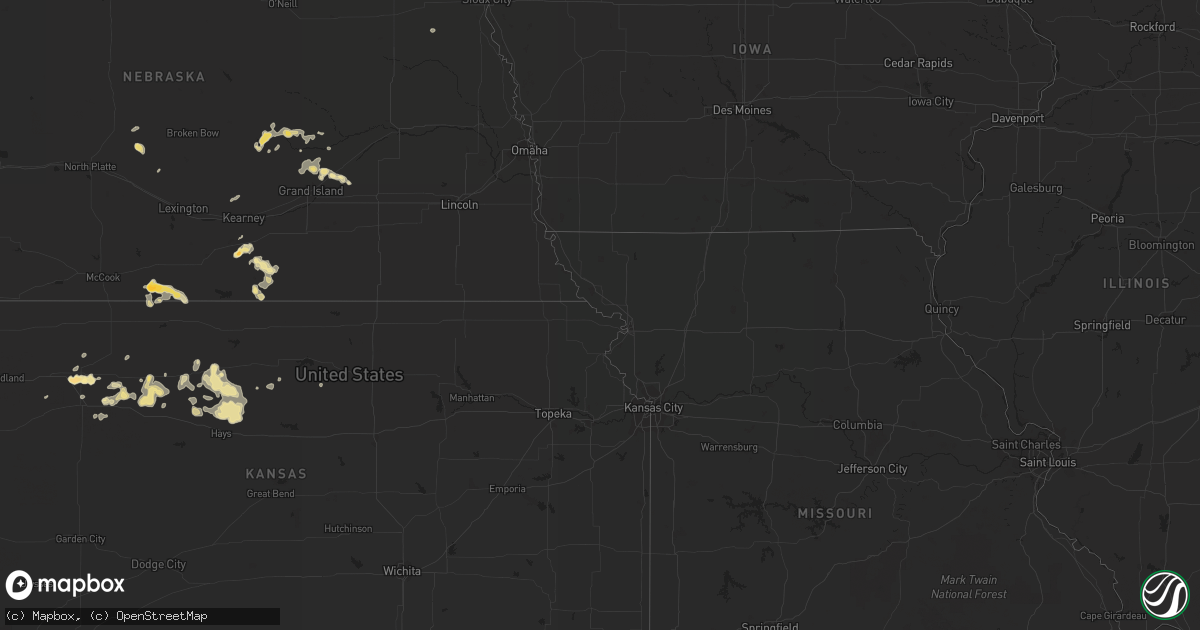
Hail Map in Kansas on July 13, 2011
Get this storm
July 13 map
$229
one time, instant access
Download today. No call, no setup
Keep the $229
Bought the map and want the full workflow? Apply the entire $229 to a subscription within 7 days. None of it is wasted.
Every map, not just this one
This buys you this map. Subscription and you get every map we run, in the markets you choose from a few cities to whole states to nationwide. Plus real-time alerts the moment a storm fires.
Contact data
Name, contact info, occupancy, even credit band for addresses in the footprint. You go from where it hit to who to call.
Become the source they trust
Unlimited branding weather history reports on demand. You already have the documented answer ready for the property owner, and you are the one who showed up with it.
Property data and RoofTrace estimates
Pull up any address you have got, its value and the exact code rules for that jurisdiction, straight from One Click Code. Then RoofTrace estimates the squares, pitch, and roof value, priced the way you price.
Storm reports in Kansas
Kansas
| Date | Description |
|---|---|
| 07/13/20115:45 PM CDT | Estimated wind gusts to 50 mph. |
| 07/13/20115:05 PM CDT | Also received nickel-size hail. |
| 07/13/20114:30 PM CDT | Also had estimated wind gusts to 70 mph. Tree limb damage.corrected for time. |
| 07/13/20113:30 PM CDT | Also had estimated wind gusts to 70 mph. Tree limb damage. |
| 07/12/20118:42 PM CDT | A local report indicates 65 MPH wind near 3 S STOCKTON |
| 07/12/20117:25 PM CDT | A local report indicates 60 MPH wind near 7 N HARDTNER |
| 07/12/20117:17 PM CDT | A local report indicates 60 MPH wind near 10 S HILL CITY |
| 07/12/20117:10 PM CDT | A local report indicates 60 MPH wind near 5 SW SAINT PETER |
All States Impacted by Hail Map on July 13, 2011
Cities Impacted by Hail Map on July 13, 2011
- Huntington, UT
- Trussville, AL
- Leeds, AL
- Birmingham, AL
- Rome, GA
- Brunson, SC
- Malvern, AR
- Fort Collins, CO
- Broadview, MT
- Acton, MT
- Whitlash, MT
- Cassatt, SC
- Bishopville, SC
- Camden, SC
- Millport, AL
- Covington, GA
- Great Falls, MT
- Callaway, NE
- Gothenburg, NE
- Brady, NE
- Berry, AL
- Cascade, MT
- Lewistown, MT
- Bruce, MS
- Water Valley, MS
- Sedalia, CO
- Watonga, OK
- Box Elder, MT
- Monticello, AR
- Wilmar, AR
- Monroe, LA
- West Monroe, LA
- Hill City, KS
- Bogue, KS
- Green River, UT
- Vernal, UT
- Belt, MT
- Troutman, NC
- Mooresville, NC
- Cleveland, NC
- Statesville, NC
- Charleston, MS
- Elk City, ID
- Shepherd, MT
- Kalispell, MT
- Somers, MT
- Vega, TX
- Goodwell, OK
- Farmerville, LA
- Oakboro, NC
- Polkton, NC
- Marshville, NC
- Abbeville, MS
- Oxford, MS
- Wayne, NE
- Robbins, NC
- Seagrove, NC
- Chinook, MT
- Carthage, NC
- White Sulphur Springs, MT
- Louviers, CO
- Littleton, CO
- Bethune, SC
- Aurora, CO
- Bard, NM
- San Jon, NM
- Marysville, MT
- Lincoln, MT
- Canyon Creek, MT
- Colorado Springs, CO
- Quitman, AR
- Plainville, KS
- Natoma, KS
- Stockton, KS
- Timnath, CO
- Orange, VA
- Granite Canon, WY
- Cheyenne, WY
- Livermore, CO
- Stockett, MT
- Brooklyn, MS
- Beaumont, MS
- McLain, MS
- Abbeville, AL
- Newville, AL
- West, MS
- Hardtner, KS
- Booneville, AR
- Blountsville, AL
- Hayden, AL
- Scott, AR
- Lonoke, AR
- Hoxie, KS
- Washington, GA
- Green Bay, VA
- Victoria, VA
- Marquette, NE
- Matheson, CO
- Polaris, MT
- Dillon, MT
- Mantee, MS
- Hamburg, AR
- Crossett, AR
- Riverton, NE
- Franklin, NE
- Rexford, KS
- Thompson, UT
- Pine Bluff, AR
- Altheimer, AR
- Grady, AR
- Vaiden, MS
- Saint Libory, NE
- Saint Paul, NE
- Palmer, NE
- Bastrop, LA
- Benton, AR
- Thomasville, AL
- Chester, SC
- Blackstock, SC
- Swanquarter, NC
- Empire, AL
- Bremen, AL
- Molino, FL
- Helena, MT
- Greenwood, AR
- Rison, AR
- Buffalo, WY
- Solgohachia, AR
- Gould, AR
- Stuttgart, AR
- Gillett, AR
- De Witt, AR
- Denver, CO
- Sterlington, LA
- Hamptonville, NC
- Hamlet, NC
- Hot Springs National Park, AR
- Pearcy, AR
- Springfield, AR
- Damascus, AR
- Hattiesburg, MS
- Perryville, AR
- Prattsville, AR
- Hartford, AR
- Mansfield, AR
- Huntington, AR
- Polson, MT
- Gordo, AL
- Fritch, TX
- Masterson, TX
- Lloyd, MT
- Spiro, OK
- Cameron, OK
- Pocola, OK
- Loveland, CO
- Taylorsville, NC
- Morland, KS
- Penokee, KS
- Collyer, KS
- Townsend, MT
- Norwood, NC
- Locust, NC
- Albemarle, NC
- Mount Pleasant, NC
- Edgemoor, SC
- Rock Hill, SC
- Ferron, UT
- Mulberry, AR
- Bladenboro, NC
- Clarkton, NC
- Colby, KS
- Lexington, SC
- Gilbert, SC
- Batesburg, SC
- Leesville, SC
- Hot Springs Village, AR
- Hogeland, MT
- Clarendon, NC
- Chadbourn, NC
- Norton, KS
- Wilsonville, NE
- Norcatur, KS
- Carthage, AR
- Leola, AR
- Winchester, VA
- Stephenson, VA
- Berryville, VA
- Newberry, SC
- Pomaria, SC
- Whitmire, SC
- Wisdom, MT
- Keota, OK
- Bokoshe, OK
- Hildreth, NE
- Minden, NE
- Wilcox, NE
- Axtell, NE
- Kingsland, AR
- Almyra, AR
- Sherrill, AR
- Star City, AR
- White Hall, AR
- Viborg, SD
- Currie, NC
- Rocky Point, NC
- Ringwood, OK
- Tabor City, NC
- Galivants Ferry, SC
- Loris, SC
- Green Sea, SC
- Conway, SC
- Aynor, SC
- Rutherfordton, NC
- Lake Lure, NC
- Marion, NC
- Old Fort, NC
- Union Mills, NC
- Bailey, NC
- Sims, NC
- Rawlins, WY
- Kings Mountain, NC
- Cherryville, NC
- Shelby, NC
- Romance, AR
- Mount Vernon, AR
- Meridian, MS
- Enterprise, MS
- Ryegate, MT
- Lavina, MT
- Molt, MT
- Wetumpka, AL
- Fayette, AL
- Jackson, MT
- Tuskegee, AL
- Tallassee, AL
- Shorter, AL
- Columbia, SC
- Bismarck, AR
- Chunky, MS
- Cut Bank, MT
- Shannon, NC
- Lumber Bridge, NC
- Red Springs, NC
- Trinidad, CO
- Scotia, NE
- Elba, NE
- Buffalo Creek, CO
- Conifer, CO
- Georgetown, SC
- Berthoud, CO
- Lyons, CO
- Windsor, CO
- Dodson, MT
- Park City, MT
- Farwell, MN
- Anadarko, OK
- Ninety Six, SC
- Forest, VA
- Hendley, NE
- Almena, KS
- Beaver City, NE
- Elizabethtown, NC
- Garland, NC
- Elbert, CO
- Elizabeth, CO
- Okeene, OK
- Madison, GA
- Columbia, LA
- Big Sandy, MT
- Kremlin, MT
- Louise, MS
- McClellanville, SC
- Jamestown, SC
- Enola, AR
- Greenbrier, AR
- Jacksonville, AR
- England, AR
- Vilonia, AR
- Conway, AR
- Little Rock Air Force Base, AR
- Cabot, AR
- Lakeville, MA
- Pangburn, AR
- Searcy, AR
- Letona, AR
- Mcalister, NM
- Aline, OK
- Loup City, NE
- Ashton, NE
- North Loup, NE
- Tie Siding, WY
- Buford, WY
- Ashburn, VA
- Round Hill, VA
- Haymarket, VA
- Purcellville, VA
- Middleburg, VA
- Aldie, VA
- The Plains, VA
- Leesburg, VA
- Wagener, SC
- Aiken, SC
- Keenesburg, CO
- Hudson, CO
- Bennett, CO
- Commerce City, CO
- Watkins, CO
- Texhoma, OK
- Vale, NC
- Victoria, KS
- Catharine, KS
- Gorham, KS
- Ellis, KS
- Hays, KS
- Bearden, AR
- Hampton, AR
- Chapman, NE
- Wagram, NC
- Fountain, CO
- State Line, MS
- Goode, VA
- Jack, AL
- Stony Point, NC
- Hiddenite, NC
- South Royalton, VT
- Sharon, VT
- Hopkins, SC
- Craig, CO
- Grover, NC
- Blacksburg, SC
- Hobson, MT
- Cordesville, SC
- Glendo, WY
- Billings, MT
- Angela, MT
- Rosebud, MT
- Wolf Creek, MT
- Oilmont, MT
- Lancaster, SC
- Clayton, NM
- Brandon, MS
- Braxton, MS
- Winnsboro, SC
- Cleo Springs, OK
- Moncks Corner, SC
- Ladson, SC
- Goose Creek, SC
- Summerville, SC
- Gordonsville, VA
- Louisa, VA
- Slater, CO
- Bloomington, NE
- Russellville, AR
- Rye, CO
- Anaconda, MT
- Star, NC
- Foster, VA
- Cardinal, VA
- North, VA
- Mathews, VA
- Thomaston, AL
- Catherine, AL
- Union, SC
- Liberty, NC
- Julian, NC
- Greensboro, NC
- Tignall, GA
- Greenwood, SC
- Livingston, AL
- Sparkman, AR
- Whiteville, NC
- Glenwood, AR
- Dover, AR
- Manville, WY
- Reform, AL
- Maxton, NC
- Hickory Flat, MS
- Etta, MS
- Myrtle, MS
- Potts Camp, MS
- Thaxton, MS
- Peyton, CO
- Sardis, MS
- Batesville, MS
- Hartsville, SC
- Sims, AR
- Deer Lodge, MT
- Alexandria, MN
- Englewood, CO
- Campbell, NE
- Upland, NE
- Wakeeney, KS
- McDavid, FL
- Sanford, NC
- Broadway, NC
- Uniontown, AL
- Tylertown, MS
- Wolbach, NE
- Paris, AR
- Lumberton, NC
- Pueblo, CO
- Tifton, GA
- Dannebrog, NE
- Avon, MT
- Elberton, GA
- Mechanicsville, MD
- Moab, UT
- Charlotte Hall, MD
- Zebulon, NC
- Bunn, NC
- Louisburg, NC
- Spring Hope, NC
- Moore, MT
- Mount Croghan, SC
- Traskwood, AR
- Atkinson, NC
- Como, MS
- Larkspur, CO
- Bluemont, VA
- Longmont, CO
- Winston, MT
- Parker, CO
- Melrose, NM
- Bogue Chitto, MS
- Spearsville, LA
- Ridgeway, SC
- Elgin, SC
- Loyal, OK
- Omega, OK
- Kingfisher, OK
- Aberdeen, NC
- Southern Pines, NC
- Raeford, NC
- Fort Bragg, NC
- Hitchcock, OK
- Hampton, NE
- Central City, NE
- La Plata, MD
- Rose Bud, AR
- Shelby, MT
- Laurel Hill, NC
- Rockingham, NC
- Monroe, NC
- Indian Trail, NC
- Bailey, CO
- Kiowa, CO
- Inwood, IA
- Canton, SD
- Clarks Hill, SC
- Waynesboro, MS
- Silas, AL
- Gable, SC
- New Zion, SC
- York, AL
- Columbia, MS
- Lugoff, SC
- Ty Ty, GA
- Sumner, GA
- Huger, SC
- Boulder, CO
- Raynesford, MT
- Heber Springs, AR
- Highwood, MT
- Dutton, VA
- Gloucester, VA
- Springville, AL
- Ellerbe, NC
- Candor, NC
- Dickinson, AL
- Magazine, AR
- Bonanza, UT
- Cumming, GA
- Fairview, OK
- Safford, AL
- Orrville, AL
- Thermopolis, WY
- Florence, SC
- Columbus, MS
- Steens, MS
- Caledonia, MS
- Shoup, ID
- Pomfret, MD
- Newburg, MD
- Faulkner, MD
- Bel Alton, MD
- Port Tobacco, MD
- Harkers Island, NC
- Royal, AR
- Ferguson, NC
- Wellington, CO
- Laporte, CO
- Louin, MS
- Opelika, AL
- Maple Hill, NC
- Raleigh, MS
- Sherwood, AR
- Helena, OK
- Fairfield, AL
- Dolomite, AL
- Wise River, MT
- Sheridan, WY
- Marion, LA
- Jessieville, AR
- Duchesne, UT
- Lennox, SD
- Centerville, SD
- Atkins, AR
- London, AR
- Pottsville, AR
- Gilbert, LA
- Ivanhoe, NC
- Delhi, LA
- Arley, AL
- China Grove, NC
- Mount Ulla, NC
- Silverstreet, SC
- Chappells, SC
- Texline, TX
- Stephens, AR
- Atmore, AL
- Alva, OK
- Simla, CO
- Hickory, NC
- Newton, NC
- Beloit, KS
- Salisbury, NC
- Bessemer, AL
- Lillie, LA
- Bigfork, MT
- Laurinburg, NC
- Rowland, NC
- Saint Stephen, SC
- Leakesville, MS
- Grinnell, KS
- West Point, MS
- Byers, CO
- Wiggins, CO
- Chugwater, WY
- Landis, NC
- Lincolnton, GA
- Newborn, GA
- Mathews, AL
- Mena, AR
- Bonneau, SC
- Gem, KS
- Two Dot, MT
- Kenton, OK
- Shorterville, AL
- Fort Morgan, CO
- Grove Hill, AL
- Newbern, AL
- West End, NC
- Pinehurst, NC
- Hayden, CO
- Courtland, MS
- Columbus, GA
- Fordyce, AR
- Augusta, AR
- Bald Knob, AR
- Grainfield, KS
- Tallulah, LA
- Marston, NC
- Yazoo City, MS
- Bentonia, MS
- Isabella, OK
- Charlotte, NC
- Concord, NC
- Harrisburg, NC
- Midland, NC
- Brush, CO
- Akron, CO
- Notasulga, AL
- Junction City, AR
- Kinards, SC
- Clover, SC
- Springfield, CO
- Camden, AL
- Vredenburgh, AL
- Hays, MT
- Thornton, AR
- Fountain Hill, AR
- Calhan, CO
- Jasper, AL
- Pine, CO
- Harlem, MT
- Morven, NC
- Wadesboro, NC
- Rock Valley, IA
- Herndon, VA
- Sapphire, NC
- Ramer, AL
- Oakley, KS
- Dalhart, TX
- Amity, AR
- Kirby, AR
- Lakeside, MT
- Castle Rock, CO
- Lone Tree, CO
- Chapin, SC
- Kershaw, SC
- Waldron, AR
- Jefferson, SC
- McBee, SC
- Strasburg, CO
- Wanette, OK
- Macomb, OK
- Kensington, MN
- Wheat Ridge, CO
- Philadelphia, MS
- Loring, MT
- Buhl, AL
- Bonnerdale, AR
- Belton, SC
- Honea Path, SC
- Hanceville, AL
- Saluda, SC
- Epes, AL
- Middlesex, NC
- Franklinton, NC
- Youngsville, NC
- Creedmoor, NC
- Wake Forest, NC
- Stanfield, NC
- Shady Dale, GA
- Monticello, GA
- Stonewall, MS
- Addison, AL
- Houston, AL
- Mcdonough, GA
- Jackson, GA
- Elrod, AL
- Sandy Hook, MS
- Crouse, NC
- Saint Pauls, NC
- Prosperity, SC
- Barnesville, GA
- Subiaco, AR
- New Blaine, AR
- Milton, FL
- Bradley, SC
- Sheridan, AR
- Riegelwood, NC
- Morrison, CO
- Faunsdale, AL
- Browning, MT
- Colorado City, CO
- Ridge Spring, SC
- Trenton, SC
- Evergreen, NC
- Baskin, LA
- Adrian, TX
- Fitzpatrick, AL
- Sparta, GA
- Mount Gilead, NC
- McDonald, TN
- Osborne, KS
- Waldo, KS
- Johnston, SC
- Ward, SC
- Eastman, GA
- Talbotton, GA
- Farwell, NE
- Arlington, GA
- Limon, CO
- Chattanooga, TN
- Waxhaw, NC
- Clancy, MT
- Eupora, MS
- Stewart, MS
- Tutwiler, MS
- Hays, NC
- Denton, GA
- Hazlehurst, GA
- Petal, MS
- Ovett, MS
- Lambert, MS
- Marks, MS
- Enid, MS
- Fitzgerald, GA
- Havre, MT
- Lucedale, MS
- McLeod, MT
- Evergreen, CO
- Golden, CO
- Yadkinville, NC
- Scranton, SC
- Coward, SC
- Gloucester, NC
- Beaufort, NC
- York, SC
- Hodges, SC
- Hartsfield, GA
- Moultrie, GA
- Gold Creek, MT
- Quinter, KS
- Morton, TX
- Dawsonville, GA
- Ball Ground, GA
- Lamar, SC
- Kevin, MT
- Ashville, AL
- Darby, MT
- Greenwood, FL
- Marianna, FL
- Malone, FL
- Titus, AL
- Donaldson, AR
- Ragland, AL
- Guy, AR
- Roggen, CO
- Sweet Water, AL
- Pennington, AL
- Raleigh, NC
- Garner, NC
- Hartman, AR
- Scranton, AR
- Crane Hill, AL
- Shelby, MS
- Winnsboro, LA
- Anguilla, MS
- Butler, AL
- Double Springs, AL
- Kingstree, SC
- Salters, SC
- Buckatunna, MS
- Millry, AL
- Paron, AR
- Muleshoe, TX
- Lonsdale, AR
- Spotsylvania, VA
- Lilesville, NC
- Hoffman, NC
- Lauderdale, MS
- Mendenhall, MS
- Greycliff, MT
- Carthage, MS
- Walnut Grove, MS
- Richton, MS
- Irene, SD
- Biscoe, NC
- Phenix City, AL
- Riverdale, NE
- Amherst, NE
- Mocksville, NC
- Harmony, NC
- Boulder, MT
- Newport, NC
- Story, AR
- Pencil Bluff, AR
- Matthews, NC
- Palco, KS
- Hennessey, OK
- Dover, OK
- Rockwell, NC
- Kannapolis, NC
- Stanford, MT
- Geyser, MT
- Wagarville, AL
- Warm Springs, MT
- Merigold, MS
- Mound Bayou, MS
- Brighton, CO
- Thornton, CO
- Worthing, SD
- Windsor, SC
- Fort Smith, AR
- Montgomery, AL
- Ooltewah, TN
- Bellvue, CO
- Traphill, NC
- Thurmond, NC
- Ozark, AR
- Drasco, AR
- Sterling, VA
- Plainview, AR
- Tichnor, AR
- Demopolis, AL
- Buford, GA
- Aberdeen, MS
- Quitman, MS
- New Edinburg, AR
- Taylorsville, MS
- Bay Springs, MS
- Wendell, NC
- El Paso, AR
- Austin, AR
- Timmonsville, SC
- Pine Hill, AL
- Magnolia, AL
- Bozeman, MT
- Lafayette, AL
- Moody, AL
- Folsom, LA
- Augusta, GA
- Mulga, AL
- Adger, AL
- Clarksdale, MS
- Duncanville, AL
- Cottondale, AL
- Cuba, AL
- Ralph, AL
- Cape Charles, VA
- Stapleton, NE
- Arnold, NE
- Tuscaloosa, AL
- Grapevine, AR
- Broxton, GA
- Cordele, GA
- Vienna, GA
- Sunburst, MT
- Poyen, AR
- Selden, KS
- Fruitdale, AL
- Evington, VA
- Louisville, CO
- Awendaw, SC
- Lynchburg, VA
- Adamsville, AL
- Graysville, AL
- Idaho Springs, CO
- Greenville, AL
- Floyd, NM
- Melvin, AL
- Gilbertown, AL
- Cedar Island, NC
- Purlear, NC
- Wilkesboro, NC


