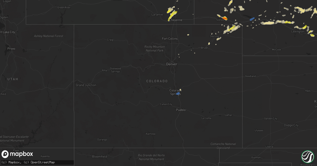
Hail Map in Colorado on July 12, 2019
Get this storm
July 12 map
$229
one time, instant access
Download today. No call, no setup
Keep the $229
Bought the map and want the full workflow? Apply the entire $229 to a subscription within 7 days. None of it is wasted.
Every map, not just this one
This buys you this map. Subscription and you get every map we run, in the markets you choose from a few cities to whole states to nationwide. Plus real-time alerts the moment a storm fires.
Contact data
Name, contact info, occupancy, even credit band for addresses in the footprint. You go from where it hit to who to call.
Become the source they trust
Unlimited branding weather history reports on demand. You already have the documented answer ready for the property owner, and you are the one who showed up with it.
Property data and RoofTrace estimates
Pull up any address you have got, its value and the exact code rules for that jurisdiction, straight from One Click Code. Then RoofTrace estimates the squares, pitch, and roof value, priced the way you price.
Storm reports in Colorado
Colorado
| Date | Description |
|---|---|
| 07/12/20193:04 PM CDT | Asos station kcos colorado springs airport. |
| 07/12/20191:52 AM CDT | At 651 PM MDT, a severe thunderstorm was located over Lodgepole, or 12 miles west of Chappell, moving east at 25 mph. HAZARD...Golf ball size hail and 60 mph wind gusts. SOURCE...Radar indicated. IMPACT...People and animals outdoors will be injured. Expect hail damage to roofs, siding, windows, and vehicles. Expect wind damage to roofs, siding, and trees. Locations impacted include... Chappell and Mount Vernon. This includes Interstate 80 in Nebraska between mile markers 78 and98. |
| 07/12/20191:47 AM CDT | At 647 PM MDT, a severe thunderstorm was located 5 miles southeast of Crook, or 24 miles southwest of Chappell, moving northeast at 20 mph. HAZARD...60 mph wind gusts and quarter size hail. SOURCE...Radar indicated. IMPACT...Expect damage to roofs, siding, and trees. Hail damage to vehicles is expected. Locations impacted include... Sedgwick and Marks Butte. |
| 07/11/20198:30 PM CDT | A local report indicates 1.00 inch wind near OVID |
All States Impacted by Hail Map on July 12, 2019
Cities Impacted by Hail Map on July 12, 2019
- Amidon, ND
- Lakeside, NE
- Ellsworth, NE
- Sidney, NE
- Martinsdale, MT
- Lisco, NE
- Oshkosh, NE
- Ponca, NE
- Dickinson, ND
- Lefor, ND
- Froid, MT
- Bainville, MT
- Twin Bridges, MT
- Angora, NE
- Alliance, NE
- Newcastle, WY
- Ontonagon, MI
- Bruce Crossing, MI
- Mass City, MI
- Rockland, MI
- Kearney, NE
- Axtell, NE
- Tioga, ND
- Gillette, WY
- New England, ND
- Livingston, MT
- Devils Tower, WY
- Hulett, WY
- Weston, WY
- Moorcroft, WY
- Plankinton, SD
- Wessington Springs, SD
- Letcher, SD
- White Lake, SD
- Mitchell, SD
- Kimball, SD
- Mount Vernon, SD
- Clancy, MT
- Dagmar, MT
- Winthrop, MN
- Gibbon, MN
- Chappell, NE
- Oto, IA
- Danbury, IA
- Lyons, NE
- Sheridan, WY
- Decker, MT
- Meeteetse, WY
- Battle Creek, NE
- Plentywood, MT
- Raymond, MT
- Outlook, MT
- Westby, MT
- Lodgepole, NE
- Lance Creek, WY
- Arcadia, NE
- Callaway, NE
- Cozad, NE
- Sedgwick, CO
- Whitehall, MT
- Grenora, ND
- Wing, ND
- Winston, MT
- Fulton, SD
- Alexandria, SD
- Cheyenne, WY
- Cardwell, MT
- Lewellen, NE
- Eagle Butte, SD
- Shepherd, MT
- Huntley, MT
- Loup City, NE
- Ord, NE
- Ashton, NE
- North Loup, NE
- Emery, SD
- Merrill, WI
- Rib Lake, WI
- Reserve, MT
- Boulder, MT
- Broken Bow, NE
- Merna, NE
- Ansley, NE
- Gladstone, ND
- Regent, ND
- New Leipzig, ND
- Hettinger, ND
- Mott, ND
- Ovid, CO
- Randolph, MN
- Cannon Falls, MN
- Westerville, NE
- Akron, CO
- Hillrose, CO
- Medicine Lake, MT
- Homestead, MT
- White Earth, ND
- Stanley, ND
- Thermopolis, WY
- North Platte, NE
- Arnold, NE
- Alamo, ND
- Ray, ND
- Minneota, MN
- Cottonwood, MN
- Marshall, MN
- Canby, MN
- Huron, SD
- Artesian, SD
- Gothenburg, NE
- Briggsdale, CO
- Spencer, SD
- Grant, NE
- Townsend, MT
- Pukwana, SD
- Wakefield, NE
- Sutherland, NE
- Hershey, NE
- Wright, WY
- Highmore, SD
- Wisner, NE
- Bancroft, NE
- Pender, NE
- Buffalo, WY
- Gurley, NE
- Harrison, NE
- Anselmo, NE
- Alcester, SD
- Hemingford, NE
- Albemarle, NC
- Mount Gilead, NC
- Norwood, NC
- Stickney, SD
- Sumner, NE
- Hyannis, NE
- Ashby, NE
- Afton, WY
- Bighorn, MT
- Anthon, IA
- Musselshell, MT
- South Sioux City, NE
- Dakota City, NE
- Comstock, NE
- Merrill, IA
- Le Mars, IA
- Madrid, NE
- Locust, NC
- Midland, NC
- Ute, IA
- Eagle River, WI
- Three Lakes, WI
- Conover, WI
- Phelps, WI
- Gilman, WI
- Sheldon, WI
- Whitetail, MT
- Crook, CO
- Haxtun, CO
- Wilmington, NC
- Wrightsville Beach, NC
- Clarkfield, MN
- Scotia, NE
- Peyton, CO
- Hazen, ND
- Zap, ND
- New Salem, ND
- Beulah, ND
- Gary, SD
- Correctionville, IA
- Pierson, IA
- Kingsley, IA
- Union Mills, NC
- Bridgewater, SD
- Salem, SD
- New Prague, MN
- Hoskins, NE
- Pine Bluffs, WY
- Brady, NE
- Maxwell, NE
- Woonsocket, SD
- Ethan, SD
- Two Dot, MT
- Stanton, NE
- Oconto, NE
- Ree Heights, SD
- Miller, SD
- Crystal Falls, MI
- Watton, MI
- Norris, MT
- Clearmont, WY
- Flaxton, ND
- Mullen, NE
- Tryon, NE
- Stanton, ND
- Melville, MT
- Big Timber, MT
- Primrose, NE
- Chugwater, WY
- Hebron, ND
- Ireton, IA
- Belle Plaine, MN
- Hitchcock, SD
- Carpenter, SD
- Wood Lake, MN
- Porter, MN
- Taunton, MN
- Belview, MN
- Hanley Falls, MN
- Echo, MN
- Vesta, MN
- Caldwell, ID
- Worden, MT
- Laurel, NE
- Newcastle, NE
- Hartington, NE
- Montrose, SD
- Canistota, SD
- Decatur, NE
- Bridger, MT
- Roggen, CO
- Wiggins, CO
- Blacksburg, SC
- Gaffney, SC
- Nampa, ID
- Holcombe, WI
- Medford, WI
- Redwood Falls, MN
- Renville, MN
- Farmington, MN
- Northfield, MN
- Lakeville, MN
- Stapleton, NE
- Riverdale, NE
- Wilton, ND
- Regan, ND
- Sterling, ND
- Baldwin, ND
- Covington, MI
- Trout Creek, MI
- Redstone, MT
- Maurice, IA
- Mapleton, IA
- White Sulphur Springs, MT
- Charlotte, NC
- Lusk, WY
- Douglas, WY
- Ballantine, MT
- Glenns Ferry, ID
- King Hill, ID
- Shelby, NC
- Kings Mountain, NC
- Paxton, NE
- Kaycee, WY
- Brighton, CO
- Broadwater, NE
- Dalton, NE
- Sterling, CO
- Litchfield, NE
- Albion, NE
- Taylor, NE
- Brewster, NE
- Ludowici, GA
- Allenhurst, GA
- Norfolk, NE
- Lindsay, NE
- Newman Grove, NE
- Saint Edward, NE
- Napoleon, ND
- Tappen, ND
- Streeter, ND
- Dawson, ND
- Overton, NE
- Miller, NE
- Fort Stewart, GA
- Hawarden, IA
- Bedford, WY
- Willow Lake, SD
- Lawton, IA
- Bessemer City, NC
- Julesburg, CO
- Moville, IA
- Elsie, NE
- Iliff, CO
- Marion, NC
- Olivia, MN
- Manville, WY
- Fort Stockton, TX
- Spartanburg, SC
- Volborg, MT
- Big Springs, NE
- Gibbon, NE
- Minden, NE
- Hinesville, GA
- Wildrose, ND
- Ross, ND
- Sidnaw, MI
- Smithland, IA
- Orange City, IA
- Sioux Center, IA
- Castlewood, SD
- Lexington, NE
- Edgemont, SD
- Glen Ullin, ND
- Spalding, NE
- Concord, NC
- Buffalo Lake, MN
- Red Wing, MN
- Bridgeport, NE
- Lavina, MT
- Hudson, CO
- Williston, ND
- Tilden, NE
- Meadow Grove, NE
- Bozeman, MT
- Clear Lake, SD
- Merino, CO
- Eddyville, NE
- Amherst, NE
- Elm Creek, NE
- Flaxville, MT
- Rock Valley, IA
- Hudson, SD
- Stanfield, NC
- Oakboro, NC
- Elba, NE
- Ogallala, NE
- Harrisburg, NC
- Taylor, ND
- Canton, SD
- Pocahontas, IA
- Remsen, IA
- Fleming, CO
- Belgrade, MT
- Dillon, MT
- Stewart, MN
- Petersburg, NE
- Roundup, MT
- Lake Lure, NC
- Long Lake, WI
- Cherokee, IA
- Quimby, IA
- Amasa, MI
- Jordan, MN
- Robbins, NC
- Watersmeet, MI
- Elko New Market, MN
- Prior Lake, MN
- Bingham, NE
- Coleridge, NE
- New London, NC
- Denton, NC
- Green Isle, MN
- Glencoe, MN
- Arlington, MN
- Wellington, NV
- Wolsey, SD
- Neligh, NE
- Candor, NC
- Webster, MN
- Dixon, NE
- Pilger, NE
- Otis, CO
- Hector, MN
- Beemer, NE
- Arthur, NE
- Brunswick, GA
- Bird Island, MN
- Franklin, MN
- Jackson, NE
- Jefferson, SD
- Dunning, NE
- Toston, MT
- Elk Point, SD
- Center, ND
- Colorado Springs, CO
- Fountain, CO
- Nisula, MI
- Blythewood, SC
- Keystone, NE
- Palermo, ND
- Cologne, MN
- Shakopee, MN
- Savage, MN
- Chaska, MN
- Rosemount, MN
- Brownton, MN
- Norwood Young America, MN
- Carver, MN
- Young America, MN
- Burnsville, MN
- Fairfax, MN
- Hamburg, MN
- Gaylord, MN
- New Auburn, MN
- Henderson, MN
- Saint Paul, MN
- Plato, MN
- Morton, MN
- East Helena, MT


