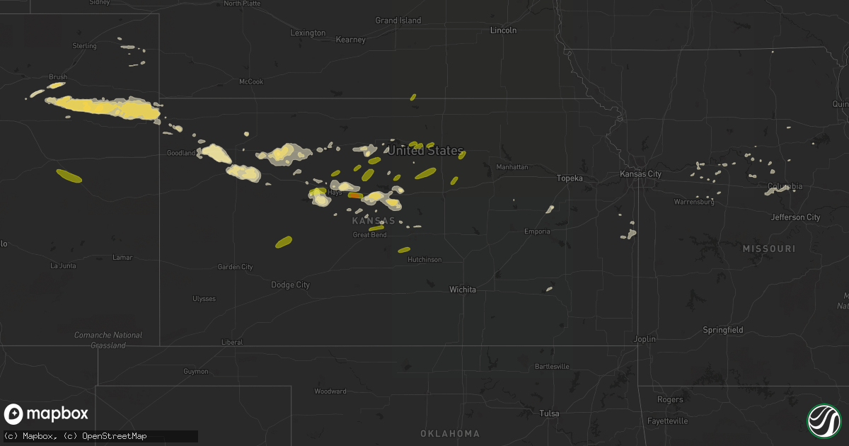
Hail Map in Kansas on July 12, 2016
Get this storm
July 12 map
$229
one time, instant access
Download today. No call, no setup
Keep the $229
Bought the map and want the full workflow? Apply the entire $229 to a subscription within 7 days. None of it is wasted.
Every map, not just this one
This buys you this map. Subscription and you get every map we run, in the markets you choose from a few cities to whole states to nationwide. Plus real-time alerts the moment a storm fires.
Contact data
Name, contact info, occupancy, even credit band for addresses in the footprint. You go from where it hit to who to call.
Become the source they trust
Unlimited branding weather history reports on demand. You already have the documented answer ready for the property owner, and you are the one who showed up with it.
Property data and RoofTrace estimates
Pull up any address you have got, its value and the exact code rules for that jurisdiction, straight from One Click Code. Then RoofTrace estimates the squares, pitch, and roof value, priced the way you price.
Storm reports in Kansas
Kansas
| Date | Description |
|---|---|
| 07/12/20166:52 AM CDT | A local report indicates 59 MPH wind near ELLSWORTH AIRPORT |
| 07/12/20166:50 AM CDT | Tree limbs 3 to 5 inch in diameter knocked down in both glen elder and cawker city. |
| 07/12/20166:46 AM CDT | A local report indicates 60 MPH wind near WILSON |
| 07/12/20166:40 AM CDT | Picture sent to kwch of a tree with a diameter of approximately a foot to two feet down on a truck. Time is estimated from radar. |
| 07/12/20166:35 AM CDT | Trained spotter reports multiple cedar trees are down in his yard. Time is approximated from other reports of highest wind speeds. |
| 07/12/20166:30 AM CDT | Facebook report of 60 to 70 mph winds. Time is estimated from radar. |
| 07/12/20166:25 AM CDT | Reports via the kake and kwch of tree damage in russell. Time is based on wind measurements from airport. |
| 07/12/20166:23 AM CDT | A local report indicates 77 MPH wind near RUSSELL AIRPORT |
| 07/12/20166:21 AM CDT | A local report indicates 73 MPH wind near RUSSELL AIRPORT |
| 07/12/20166:19 AM CDT | Galatia fire chief estimates winds in excess of 60 mph. |
| 07/12/20165:55 AM CDT | Awos station hays regional airport awos site /hys/. |
| 07/12/20165:55 AM CDT | A pole barn was destroyed by high winds. |
| 07/12/20165:50 AM CDT | Wind gust measured from home weather station. Numerous tree limbs and some power lines down in area. |
| 07/12/20165:16 AM CDT | Time est fm radar. Power outages reported in the area. |
| 07/12/20165:10 AM CDT | Tree limbs around two inches in diameter were blown down in wakeeney. . |
| 07/12/20164:57 AM CDT | A local report indicates 62 MPH wind near 9 N PENDENNIS |
| 07/12/20164:51 AM CDT | A local report indicates 59 MPH wind near HILL CITY |
| 07/12/20164:30 AM CDT | 2 power poles down causing a power outage. |
| 07/12/20164:20 AM CDT | Estimated wind gusts of 50-60 mph. |
| 07/12/20164:20 AM CDT | Very strong winds accompanied the hail. No estimate on the speed of the wind. |
| 07/12/20163:45 AM CDT | A local report indicates 61 MPH wind near 2 E COLBY |
| 07/12/20163:02 AM CDT | A local report indicates 66 MPH wind near GOODLAND |
| 07/12/20162:57 AM CDT | Small living tree limbs down around 1/2 inch in diameter. |
| 07/12/20162:54 AM CDT | Still gusting to 59 mph. |
All States Impacted by Hail Map on July 12, 2016
Cities Impacted by Hail Map on July 12, 2016
- Thomasville, GA
- Lake City, FL
- Hoxie, KS
- Penokee, KS
- Morland, KS
- Tavares, FL
- Leesburg, FL
- Cottondale, AL
- Happy, TX
- Bunker Hill, KS
- Victoria, KS
- Hays, KS
- Gorham, KS
- Windermere, FL
- Ocoee, FL
- Gotha, FL
- Winter Garden, FL
- Colby, KS
- Grainfield, KS
- Oakley, KS
- Grinnell, KS
- Osborne, KS
- Alton, KS
- Natoma, KS
- Mclean, TX
- Edson, KS
- Orange Park, FL
- Jacksonville, FL
- Madison, MS
- Canton, MS
- Monroeville, AL
- Louisburg, KS
- Paola, KS
- Ridge Farm, IL
- Chrisman, IL
- Ambrose, GA
- Ellsworth, KS
- Wilson, KS
- Dorrance, KS
- Mayview, MO
- Higginsville, MO
- Arthur, NE
- Keystone, NE
- Monticello, FL
- Tampa, FL
- Lancaster, MO
- Ochlocknee, GA
- Jacksonville, IL
- Wiggins, CO
- Monument, KS
- Brewster, KS
- Gove, KS
- Levant, KS
- McAlpin, FL
- O'Brien, FL
- Tuscaloosa, AL
- Duncanville, AL
- Ochopee, FL
- Danville, IL
- Ellis, KS
- McCracken, KS
- Green Cove Springs, FL
- Fleming Island, FL
- Claude, TX
- Clarendon, TX
- Hill City, KS
- Haxtun, CO
- Bonifay, FL
- Caryville, FL
- Lake Park, GA
- Stockton, KS
- Damar, KS
- Sylvan Grove, KS
- Lincoln, KS
- Rexford, KS
- Lindon, CO
- Blackburn, MO
- Malta Bend, MO
- Woodrow, CO
- Yuma, CO
- Akron, CO
- Monterey, IN
- Culver, IN
- Lemoyne, NE
- Marianna, FL
- Alford, FL
- Live Oak, FL
- Atkinson, NE
- Apopka, FL
- Whigham, GA
- Kirk, CO
- Eckley, CO
- Wray, CO
- Brush, CO
- Joes, CO
- Fort Morgan, CO
- Vernon, CO
- Idalia, CO
- Belle Glade, FL
- Russell, KS
- Middleburg, FL
- Geneseo, KS
- Sebring, FL
- Wooldridge, MO
- Prairie Home, MO
- Rocheport, MO
- Boonville, MO
- Columbia, MO
- Pine Hill, AL
- Clayton, AL
- Valdosta, GA
- Loxahatchee, FL
- Ponce De Leon, FL
- Westville, FL
- Armstrong, MO
- Paoli, CO
- Osage City, KS
- Kewanna, IN
- Odessa, TX
- Pampa, TX
- Lee, FL
- Pinetta, FL
- Whatley, AL
- Dickinson, AL
- Bowling Green, FL
- Wauchula, FL
- Reading, KS
- Goshen, IN
- Millersburg, IN
- Council Grove, KS
- Dixie, GA
- Lorida, FL
- Winnabow, NC
- Concordia, MO
- Bay Springs, MS
- Rutledge, AL
- Fargo, GA
- Johnstown, NE
- Saint Francis, KS
- Grove Hill, AL
- Stoutsville, MO
- Santa Fe, MO
- Andalusia, AL
- Inglis, FL
- Lake Placid, FL
- Repton, AL
- Wray, GA
- Ocilla, GA
- Pavo, GA
- Boyden, IA
- Sheldon, IA
- Clermont, FL
- Bogue, KS
- Chunky, MS
- Pawhuska, OK
- Greenville, FL
- Higbee, MO
- Fayette, MO
- Mayo, FL
- Ligonier, IN
- Syracuse, IN
- Indiantown, FL
- Okeechobee, FL
- Palatka, FL
- Beloit, KS
- Brooker, FL
- Downs, KS
- Chambers, NE
- Marshall, MO
- Miami, MO
- Slater, MO
- McIntosh, AL
- Paris, IL
- Immokalee, FL
- Tallahassee, FL
- Canyon, TX
- Matlock, IA
- Ashton, IA
- Hull, IA
- Lake Butler, FL
- La Cygne, KS
- Paxton, NE
- Alachua, FL
- Williston, FL
- Waverly, MO
- Milford, IN
- New Paris, IN
- Topeka, IN
- Dana, IN
- Camden, AL
- Holyrood, KS
- Lorraine, KS
- Sylacauga, AL
- Cromwell, IN
- Atmore, AL
- Naylor, GA
- Boston, GA
- Hickory, MS
- Enterprise, MS
- Tilton, IL
- Holyoke, CO
- Hoisington, KS
- Claflin, KS
- McDavid, FL
- Goshen, AL
- Luverne, AL
- Selden, KS
- Covington, IN
- Bismarck, IL
- Cottondale, FL
- Sturgis, KY
- Bryceville, FL
- Harrisburg, MO
- Quincy, FL
- Ainsworth, NE
- Otis, KS
- Westville, IL
- Rock Valley, IA
- La Monte, MO
- Vermillion, SD
- Gayville, SD
- Keystone Heights, FL
- Eufaula, AL
- Abbeville, AL
- Bronson, FL
- Fall River, KS
- Plant City, FL
- Copan, OK
- Emmet, NE
- Amelia, NE
- Niobrara, NE
- Mount Hermon, LA
- Norborne, MO
- Dover, MO
- Corder, MO
- Madison, FL
- Jasper, FL
- Quitman, GA
- Bartow, FL
- Fort Meade, FL
- Broxton, GA
- Bassett, NE
- Little River, KS
- Loxley, AL
- Longs, SC
- La Crosse, KS
- Park, KS
- Morriston, FL
- Troy, AL
- Bushnell, FL
- Hampstead, NC
- Fountain, FL
- Dover, FL
- Rochester, IN
- Barnsdall, OK
- Barney, GA
- North Fort Myers, FL
- Punta Gorda, FL
- Estero, FL
- Ocean Isle Beach, NC
- Ash, NC
- Mount Vernon, AL
- Ava, IL
- Lyons, KS
- Chiefland, FL
- Evergreen, AL
- Defuniak Springs, FL
- Freeport, FL
- Lakeland, FL
- Mount Olive, NC
- Warrensburg, MO
- Naples, FL
- Arcadia, FL
- Glasgow, MO
- Ozark, AL
- Ogallah, KS
- Bartlesville, OK
- North Judson, IN
- Saint George, GA
- Sanderson, FL
- Sturgeon, MO
- Long Pine, NE
- Knoxville, AL
- Eutaw, AL
- Tipton, KS
- Chattahoochee, FL
- Knob Noster, MO
- Sutherland, NE
- Lagrange, GA
- Clarence, MO
- Anabel, MO
- Fairmount, IL
- Indianola, IL
- Milton, FL
- Forkland, AL
- Saint Cloud, FL
- Wakeeney, KS
- Jennings, FL
- Salisbury, MO
- Olmitz, KS
- Selma, AL
- Tyler, AL
- Argos, IN
- Avon Park, FL
- New Plymouth, ID
- Opp, AL
- Homeland, FL
- Sweet Springs, MO
- Moultrie, GA
- Homosassa, FL
- Greensboro, AL
- Castleberry, AL
- Laurel Hill, FL
- Cawker City, KS
- Fort Myers, FL
- Wynot, NE
- Franklin, MO
- Glen Elder, KS
- Houstonia, MO
- Hampton, FL
- Waldo, FL
- Gainesville, FL
- Greenwood, FL
- Zolfo Springs, FL
- Skipperville, AL
- Delaware, OK
- Callahan, FL
- Pender, NE
- Bancroft, NE
- Alta, IA
- Schaller, IA
- Storm Lake, IA
- Galva, IA
- Superior, NE
- Mankato, KS
- Pomeroy, IA
- Jolley, IA
- Walker, KS
- Sterling, KS
- Jetmore, KS
- Ness City, KS
- Beeler, KS
- Cimarron, KS
- Ellinwood, KS
- Great Bend, KS
- Plainville, KS
- Waldo, KS
- Glasco, KS
- Concordia, KS
- Clay Center, KS
- Miltonvale, KS
- Barnard, KS
- Beverly, KS
- Minneapolis, KS
- Tescott, KS
- Luray, KS
- Paradise, KS
- Solomon, KS
- Hugo, CO


