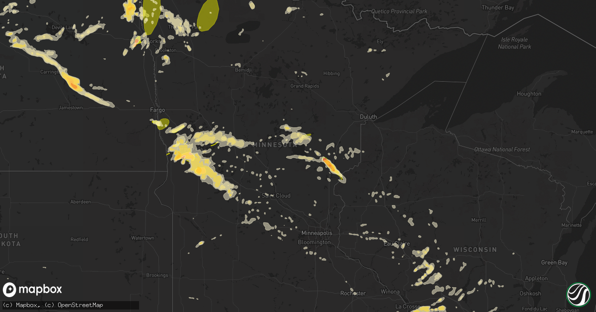
Hail Map in Minnesota on July 12, 2015
Get this storm
July 12 map
$229
one time, instant access
Download today. No call, no setup
Keep the $229
Bought the map and want the full workflow? Apply the entire $229 to a subscription within 7 days. None of it is wasted.
Every map, not just this one
This buys you this map. Subscription and you get every map we run, in the markets you choose from a few cities to whole states to nationwide. Plus real-time alerts the moment a storm fires.
Contact data
Name, contact info, occupancy, even credit band for addresses in the footprint. You go from where it hit to who to call.
Become the source they trust
Unlimited branding weather history reports on demand. You already have the documented answer ready for the property owner, and you are the one who showed up with it.
Property data and RoofTrace estimates
Pull up any address you have got, its value and the exact code rules for that jurisdiction, straight from One Click Code. Then RoofTrace estimates the squares, pitch, and roof value, priced the way you price.
Storm reports in Minnesota
Minnesota
| Date | Description |
|---|---|
| 07/12/20156:54 PM CDT | Trees and power lines down |
| 07/12/20156:52 PM CDT | Widespread tree damage along cr2... North of the staples airport. |
| 07/12/20156:50 PM CDT | Numerous large trees broken down along highway 55 corridor...between barrett and hoffman. |
| 07/12/20156:48 PM CDT | Trees and power lines down |
| 07/12/20156:45 PM CDT | Trees and power lines blown down in aldrich and between aldrich and staples along cr2. |
| 07/12/20156:45 PM CDT | Barn destroyed south of aldrich mn |
| 07/12/20156:44 PM CDT | A local report indicates 1.00 inch wind near 6 NNW FOXHOME |
| 07/12/20156:40 PM CDT | Trees blown down and a roof blown off in town. Numerous trees and and least 8 to 10 power poles snapped off east of town. |
| 07/12/20156:23 PM CDT | Trees and power lines down |
| 07/12/20156:23 PM CDT | Trees and power lines down |
| 07/12/20156:20 PM CDT | Time estimated. Fallen trees led to some power outages. |
| 07/12/20156:10 PM CDT | Trees broken down and gardens flattened. Reported via social media. |
| 07/12/20155:48 PM CDT | Between otter tail and vining. |
| 07/12/20155:31 PM CDT | Multiple sightings of a tornado near the grant county and otter tail county line. |
| 07/12/20155:14 PM CDT | A local report indicates 1.75 inch wind near 3 NNE CAMPBELL |
| 07/12/20155:14 PM CDT | A local report indicates a tornado near 2 NE CAMPBELL |
| 07/12/20155:07 PM CDT | Spotter located 2sw of doran views tornado near hwy 75 and southwest of doran. |
| 07/12/20155:05 PM CDT | Several older larger trees knocked over...some newer trees with 3-5 inch branches broken off. |
| 07/12/20154:50 PM CDT | Several 3-4 inch branches cracked and/or broken off. Time estimated from radar. |
| 07/12/201510:58 AM CDT | Observed at grand casino |
| 07/12/201510:54 AM CDT | Hail fell for ten minutes |
| 07/12/201510:53 AM CDT | At grand national golf course. |
| 07/12/201510:32 AM CDT | Delayed report. Half-inch to one inch hail. Received 0.50 inches of rain in 10 minutes. |
| 07/12/20157:20 AM CDT | Dime to quarter sized hail. |
| 07/12/201512:10 AM CDT | Tree down. Time estimated from radar. |
| 07/12/201512:00 AM CDT | Tree down. Time estimated from radar. |
| 07/11/201510:58 PM CDT | Tree down. |
| 07/11/201510:48 PM CDT | 3 trees down. Crop damage corn blown down cr 30sw. |
| 07/11/201510:40 PM CDT | Tree down across road |
| 07/11/201510:40 PM CDT | Large tree down on power line riverview dr |
| 07/11/20159:55 PM CDT | Trees down |
| 07/11/20159:45 PM CDT | Rwis road sensor |
| 07/11/20159:20 PM CDT | Tree down. Time estimated from radar. |
| 07/11/20159:16 PM CDT | Awos metar kjmr |
| 07/11/20159:10 PM CDT | Tree down. Time estimated from radar. |
| 07/11/20159:00 PM CDT | Trees down |
| 07/11/20159:00 PM CDT | Trees down |
| 07/11/20159:00 PM CDT | Semaphore trafic signal down |
| 07/11/20159:00 PM CDT | 5 inch diameter tree limbs down |
| 07/11/20158:53 PM CDT | Awos metar kd39 |
| 07/11/20158:45 PM CDT | Winds estimated 55 to 60 mph. |
| 07/11/20158:30 PM CDT | 5 to 6 uprooted trees and power outages |
| 07/11/20158:28 PM CDT | Seven trees felled... Some 18 inches in diameter. |
| 07/11/20158:20 PM CDT | A local report indicates 81 MPH wind near BOWLUS |
| 07/11/20157:50 PM CDT | Countless trees down with many blocking roadways as well as power lines down. State highway371 north of baxter is blocked and reduced. Time estimated. |
| 07/11/20157:50 PM CDT | Large tree down on house. Also hail between quarter and half dollar size |
| 07/11/20157:45 PM CDT | 5 healthy oak trees down...largest about 12 inches in diameter. |
| 07/11/20157:45 PM CDT | 31...32 and 40 inch diameter trees down. Delayed report. |
| 07/11/20157:40 PM CDT | 6 large healthy oak trees down in yard. Many other trees down across neighboorhood. Power was out until 230 am. Estimated 2 inches of rain - gage was taken out by falli |
| 07/11/20157:40 PM CDT | Trees down |
| 07/11/20157:38 PM CDT | A local report indicates 1.00 inch wind near 11 SW MCGREGOR |
| 07/11/20157:30 PM CDT | Trees down |
| 07/11/20157:27 PM CDT | Cart corrals upended at walmart |
| 07/11/20157:25 PM CDT | Large trees fell hitting powerlines. Estimated 18 inch diameter trees. |
| 07/11/20157:24 PM CDT | Power lines down |
| 07/11/20157:24 PM CDT | Report of lots of live trees down. 12 to 24 inch in diameter. Tree fell down on house and caused roof damage. |
| 07/11/20157:23 PM CDT | Two 6 inch trees uprooted |
| 07/11/20157:20 PM CDT | Trees blown down...one big oak and others...tv antenna and tower blown down. |
| 07/11/20157:18 PM CDT | 3-4 inch diameter tree branches down on a live oak tree. |
| 07/11/20157:17 PM CDT | Two to three eight to twelve inch diameter live pine trees topped. |
| 07/11/20157:15 PM CDT | Lost part of garage roof. |
| 07/11/20157:15 PM CDT | Pontoon boat thrown into maple lake and flipped over. Time estimated. |
| 07/11/20157:15 PM CDT | 2 foot diameter tree down event time 1900-1930 cdt |
| 07/11/20157:14 PM CDT | Large shed under contruction partially destroyed. Damage occurred on halverson road a few blocks south of county road 82. Time estimated. |
| 07/11/20157:10 PM CDT | Large trees split open. Occurred sporadically from 3 to 4 miles se of town along county road 82. Time of event estimated. |
| 07/11/20157:10 PM CDT | Large trees split open on north side of town. Time estimated. |
| 07/11/20157:09 PM CDT | Pine trees up rooted |
| 07/11/20157:09 PM CDT | Estimated |
| 07/11/20157:05 PM CDT | A local report indicates 1.00 inch wind near 4 N WOLVERTON |
All States Impacted by Hail Map on July 12, 2015
Cities Impacted by Hail Map on July 12, 2015
- Harvey, ND
- Sandstone, MN
- Brook Park, MN
- Pine City, MN
- Hinckley, MN
- Grantsburg, WI
- Newnan, GA
- Thief River Falls, MN
- Garfield, MN
- Glenwood, MN
- Barrett, MN
- Kensington, MN
- Lowry, MN
- Evansville, MN
- Ashby, MN
- Elbow Lake, MN
- Villard, MN
- Alexandria, MN
- Farwell, MN
- Brandon, MN
- Onamia, MN
- Isle, MN
- Wahkon, MN
- Merrillan, WI
- Neillsville, WI
- Black River Falls, WI
- Juneau, WI
- Horicon, WI
- Michigan, ND
- Lakota, ND
- Aitkin, MN
- Belle Fourche, SD
- Plain, WI
- Loganville, WI
- North Freedom, WI
- Quemado, NM
- Belcourt, ND
- Holdingford, MN
- Bowlus, MN
- Barronett, WI
- Cumberland, WI
- Mcgregor, MN
- Sturgeon Lake, MN
- McGrath, MN
- Osseo, WI
- Kensal, ND
- Courtenay, ND
- Solway, MN
- Rio, WI
- Deforest, WI
- Fall River, WI
- Marshall, WI
- Beaver Dam, WI
- Columbus, WI
- Carrington, ND
- Swanville, MN
- Rockford, IL
- Winnebago, IL
- Durand, IL
- Shirland, IL
- Rockton, IL
- Warrens, WI
- Pittsville, WI
- Newfolden, MN
- Viking, MN
- Argyle, MN
- Perham, MN
- Battle Lake, MN
- Bluffton, MN
- Richville, MN
- Ottertail, MN
- Deer Creek, MN
- Erhard, MN
- Fergus Falls, MN
- Wadena, MN
- Underwood, MN
- New York Mills, MN
- Dent, MN
- Henning, MN
- Farmington, NM
- Bloomfield, NM
- Racine, WI
- Humbird, WI
- Stanley, WI
- Boyd, WI
- Cathay, ND
- New Rockford, ND
- Cherry Valley, IL
- Kirkland, IL
- Belvidere, IL
- Dekalb, IL
- Waterman, IL
- Somonauk, IL
- Cortland, IL
- Hinckley, IL
- Kingston, IL
- Clare, IL
- Sycamore, IL
- Babbitt, MN
- Watertown, WI
- Johnson Creek, WI
- Sylvania, GA
- Ontario, WI
- Rockland, WI
- Stoddard, WI
- Viroqua, WI
- Bangor, WI
- Genoa, WI
- Norwalk, WI
- Westby, WI
- Coon Valley, WI
- Chaseburg, WI
- Elroy, WI
- Kendall, WI
- Sparta, WI
- La Crosse, WI
- Wilton, WI
- Hillsboro, WI
- Cashton, WI
- Maple Lake, MN
- Buffalo, MN
- Rogers, ND
- Moriarty, NM
- Saint Olaf, IA
- Vergas, MN
- Chapel Hill, NC
- Capitan, NM
- Moorhead, MN
- Horace, ND
- Comstock, MN
- Grand Forks, ND
- Plano, IL
- Mayer, MN
- New Germany, MN
- Watertown, MN
- Howard Lake, MN
- Winsted, MN
- Earlville, IA
- Delhi, IA
- Manchester, IA
- Greeley, IA
- Delaware, IA
- Edgewood, IA
- Hopkinton, IA
- Beloit, KS
- Glen Elder, KS
- Saint John, ND
- Crosby, MN
- Wendell, MN
- Brooten, MN
- Campbell, MN
- Dalton, MN
- Foxhome, MN
- Breckenridge, MN
- Sauk Centre, MN
- Rothsay, MN
- Hoffman, MN
- Elizabeth, MN
- Piedmont, SD
- Rapid City, SD
- Box Elder, SD
- Cubero, NM
- Bemidji, MN
- Velva, ND
- Richmond, MN
- Avon, MN
- Isabella, MN
- Ochopee, FL
- Eagle Bend, MN
- Owingsville, KY
- Willcox, AZ
- Benson, AZ
- Sturtevant, WI
- Burkesville, KY
- Celina, TN
- Hilham, TN
- Woodbine, GA
- Mauston, WI
- Valley City, ND
- Sanborn, ND
- Union Center, SD
- Newell, SD
- Whitleyville, TN
- Moss, TN
- Gainesboro, TN
- Wolford, ND
- Eau Claire, WI
- Dazey, ND
- Luverne, ND
- Grafton, ND
- Pisek, ND
- Forest River, ND
- Minto, ND
- Saint Thomas, ND
- Drayton, ND
- Eleva, WI
- Mondovi, WI
- Fessenden, ND
- Glenfield, ND
- Oriska, ND
- Grace City, ND
- Maddock, ND
- Wimbledon, ND
- Sheyenne, ND
- Rugby, ND
- Oberon, ND
- Sparta, TN
- Holcombe, WI
- New Auburn, WI
- Sharon, ND
- Pardeeville, WI
- Montello, WI
- Baraboo, WI
- Poynette, WI
- Lodi, WI
- Merrimac, WI
- Wisconsin Dells, WI
- Portage, WI
- Wyocena, WI
- Dalton, WI
- Grygla, MN
- Plainfield, WI
- Hancock, WI
- Bancroft, WI
- Tellico Plains, TN
- Hixton, WI
- Hermosa, SD
- Keystone, SD
- Lancaster, KY
- Lakeville, MN
- Littlefork, MN
- Evansville, WI
- Orfordville, WI
- Brodhead, WI
- Thompson, ND
- East Grand Forks, MN
- Camp Douglas, WI
- Necedah, WI
- Glen Haven, WI
- Lancaster, WI
- Bloomington, WI
- White Oak, GA
- Waverly, GA
- Bushnell, FL
- Crary, ND
- Oslo, MN
- Alvarado, MN
- Leland, IL
- Souris, ND
- Burnett, WI
- Nicholasville, KY
- Wilmore, KY
- Harrodsburg, KY
- Granville, ND
- Kennedy, MN
- Elkhorn, WI
- Roanoke, AL
- Esmond, ND
- Stephen, MN
- Vining, MN
- Clitherall, MN
- Pomona Park, FL
- Georgetown, FL
- Crescent City, FL
- Pelican Rapids, MN
- Ixonia, WI
- Oconomowoc, WI
- Mora, MN
- Muscoda, WI
- Viola, WI
- Richland Center, WI
- New Lisbon, WI
- Stanford, KY
- Danville, KY
- Reeseville, WI
- Arlington, WI
- Lowell, WI
- Morrisonville, WI
- Sun Prairie, WI
- Waterloo, WI
- Emerado, ND
- York, ND
- Sheldon, WI
- Gilman, WI
- Chandler, MN
- Woodstock, MN
- Calhoun, GA
- Bertha, MN
- Hewitt, MN
- Norcross, MN
- Verndale, MN
- Aldrich, MN
- Staples, MN
- Nashua, MN
- Motley, MN
- Osakis, MN
- Chiefland, FL
- Franksville, WI
- Deerwood, MN
- Palmetto, GA
- Tomah, WI
- Ely, MN
- Finlayson, MN
- Poplar Grove, IL
- Esmond, IL
- Big Rock, IL
- Malta, IL
- Garden Prairie, IL
- Sandwich, IL
- Deer River, MN
- Maynard, MN
- Clara City, MN
- Red Lake Falls, MN
- Cold Spring, MN
- Saint Cloud, MN
- Ponemah, MN
- Baudette, MN
- Saint Michael, ND
- Devils Lake, ND
- Shakopee, MN
- Prior Lake, MN
- Nemo, SD
- Willard, WI
- Fairchild, WI
- Augusta, WI
- Moneta, VA
- Cornell, WI
- Bunnell, FL
- Barnesville, MN
- Melrose, WI
- Alma Center, WI
- Cushing, MN
- Strum, WI
- Prairie Du Chien, WI
- Bagley, WI
- Fort Totten, ND
- Minnewaukan, ND
- Oregon, WI
- Crookston, MN
- Beltrami, MN
- Cohutta, GA
- Apison, TN
- Harrison, TN
- Tunnel Hill, GA
- Chattanooga, TN
- Ooltewah, TN
- Ringgold, GA
- Eden Valley, MN
- Parkers Prairie, MN
- Isanti, MN
- Tijeras, NM
- Delano, MN
- Winslow, AZ
- Hilliard, FL
- Stanley, NM
- Christine, ND
- Maple Plain, MN
- Rockford, MN
- Salt Lick, KY
- Marengo, IL
- Euclid, MN
- Fall Creek, WI
- Saint Joseph, MN
- Clarksburg, OH
- Bremen, IN
- Goshen, IN
- Wakarusa, IN
- Nappanee, IN
- Big Falls, MN
- Arpin, WI
- Vesper, WI
- Campbellsport, WI
- Fond Du Lac, WI
- Eden, WI
- Hillpoint, WI
- Bisbee, ND
- Atlanta, GA
- Wolverton, MN
- Waite Park, MN
- Prewitt, NM
- Royalton, MN
- Long Prairie, MN
- Raleigh, NC
- Folkston, GA
- Thoreau, NM
- Panacea, FL
- Saint Hilaire, MN
- Rolla, ND
- Jackson, OH
- Reedsburg, WI
- Wheatland, ND
- Perry, FL
- Milton, FL
- Granton, WI
- Chili, WI
- Brownsville, MN
- Century, FL
- Pearl City, IL
- Cottage Grove, WI
- Dassel, MN
- Northome, MN
- Watkins, MN
- Englewood, TN
- Appleton, MN
- Greenville, AL
- Fort Deposit, AL
- Mekinock, ND
- Manvel, ND
- Askov, MN
- Willow River, MN
- Bruno, MN
- Apex, NC
- Willow Spring, NC
- Fuquay Varina, NC
- Holly Springs, NC
- Garner, NC
- Chetek, WI
- Cameron, WI
- Brooks, MN
- Woodland, AL
- Clarkfield, MN
- Pierson, FL
- Corona, NM
- Pie Town, NM
- Voltaire, ND
- Guttenberg, IA
- Holy Cross, IA
- Colesburg, IA
- Silver Lake, MN
- Lester Prairie, MN
- Paynesville, MN
- Boyd, MN
- Beloit, WI
- Granville, TN
- Pleasant Shade, TN
- Chippewa Falls, WI
- Tipton, KS
- Wilson, WI
- Woodville, WI
- Climax, MN
- Fisher, MN
- Wild Rose, WI
- Almond, WI
- Wautoma, WI
- Rochester, MN
- Hammond, WI
- Baldwin, WI
- Roberts, WI
- Towner, ND
- Marion, WI
- Kent, IL
- Lena, IL
- Stockton, IL
- Boca Grande, FL
- Outing, MN
- Fence Lake, NM
- Grants, NM
- Webster, FL
- Pensacola, FL
- Burtrum, MN
- Weyerhaeuser, WI
- Birchwood, WI
- Eau Claire, MI
- Cokato, MN
- Franklin, GA
- Albany, MN
- Karlstad, MN
- Worthington, IA
- Strawberry Point, IA
- Jordan, MN
- Durham, NC
- Cary, NC
- Belgrade, MN
- Hartford, MI
- Dowagiac, MI
- Benton Harbor, MI
- Merrifield, MN
- Nisswa, MN
- Salvisa, KY
- Lawrenceburg, KY
- Friendship, WI
- Versailles, KY
- Knapp, WI
- Glenwood City, WI
- Downing, WI
- Farmington, MN
- Northfield, MN
- Menomonie, WI
- Harvard, IL
- Darien, WI
- Andover, MN
- Anoka, MN
- Spencer, WI
- Hatton, ND
- Northwood, ND
- Boyceville, WI
- Endeavor, WI
- Brainerd, MN
- Slayton, MN
- Hannaford, ND
- Brooklyn, WI
- Niagara, ND
- Brownsville, WI
- Warren, MN
- Harper, OR
- Livingston, WI
- Montfort, WI
- Rice, MN
- Anamoose, ND
- Pillager, MN
- Pequot Lakes, MN
- Neosho, WI
- Browerville, MN
- Dunseith, ND
- Roscoe, MN
- Ayr, ND
- Rice Lake, WI
- Mikana, WI
- Martin, SC
- Cascade, IA
- Saint Francis, MN
- Carlos, MN
- Nelson, MN
- Cadott, WI
- Hillman, MN
- Pine Island, MN
- Nielsville, MN
- Strandquist, MN
- Goodridge, MN
- Barron, WI
- Taunton, MN
- Reynolds, ND
- Little Falls, MN
- Brimson, MN
- Loxley, AL
- Saint Johns, AZ
- Tolna, ND
- Petersburg, ND
- Dahlen, ND
- Kimball, MN
- Redgranite, WI
- Hesperus, CO
- Karlsruhe, ND
- Ettrick, WI
- Elkader, IA
- Garber, IA
- Fairmount, GA
- Rydal, GA
- Fairhope, AL
- Silverhill, AL
- Stone Lake, WI
- Springbrook, WI
- Darwin, MN
- Dundee, IA
- Volga, IA
- Dyersville, IA
- Elgin, IA
- Wadena, IA
- Mayville, WI
- Clyman, WI
- Windsor, WI
- Lomira, WI
- Verona, WI
- Emily, MN
- Ironton, MN
- Pierz, MN
- Gulf Shores, AL
- Hestand, KY
- Tompkinsville, KY
- Menomonee Falls, WI
- Floral City, FL
- Monticello, IA
- Grasston, MN
- Lexington, KY
- Arkdale, WI
- Greenwood, WI
- Owen, WI
- Marshfield, WI
- Dane, WI
- Black Earth, WI
- Mazomanie, WI
- Buchanan, MI
- Galien, MI
- Three Oaks, MI
- Crownpoint, NM
- Loyal, WI
- Lankin, ND
- Willow City, ND
- Miltona, MN
- Randolph, MN
- Wetumpka, AL
- Decatur, MI
- Cedar Key, FL
- Sharon, WI
- Fort Pierre, SD
- Dalton, GA
- Grand Rapids, MN
- Campbellsville, KY
- Fort McCoy, FL
- Sherrill, IA
- Spicer, MN
- Kandiyohi, MN
- Atwater, MN
- Grove City, MN
- Lawton, ND
- Brocket, ND
- Granite Falls, MN
- Colfax, WI
- Haugen, WI
- Winslow, IL
- Maple Park, IL
- Sugar Grove, IL
- Elburn, IL
- Donaldson, MN
- Avalon, WI
- Delavan, WI
- Whitewater, WI
- Shelly, MN
- Ada, MN
- Danbury, WI
- Waverly, MN
- Jefferson, WI
- Helenville, WI
- Sullivan, WI
- Cambridge, WI
- Lake Mills, WI
- Deerfield, WI
- Fort Atkinson, WI
- Madison, WI
- Houston, MN
- Caledonia, MN
- Davenport, ND
- Lawrence, MI
- Litchfield, MN
- Lublin, WI
- Rock Springs, WI
- Booth, AL
- Prattville, AL
- Hendrum, MN
- Massena, IA
- Withee, WI
- Saint George, GA
- Labelle, FL
- Moore Haven, FL
- Rocky Face, GA
- Elk Mound, WI
- Shannon, IL
- Spring Valley, WI
- Ree Heights, SD
- Sabin, MN
- Wannaska, MN
- Gatzke, MN
- Bottineau, ND


