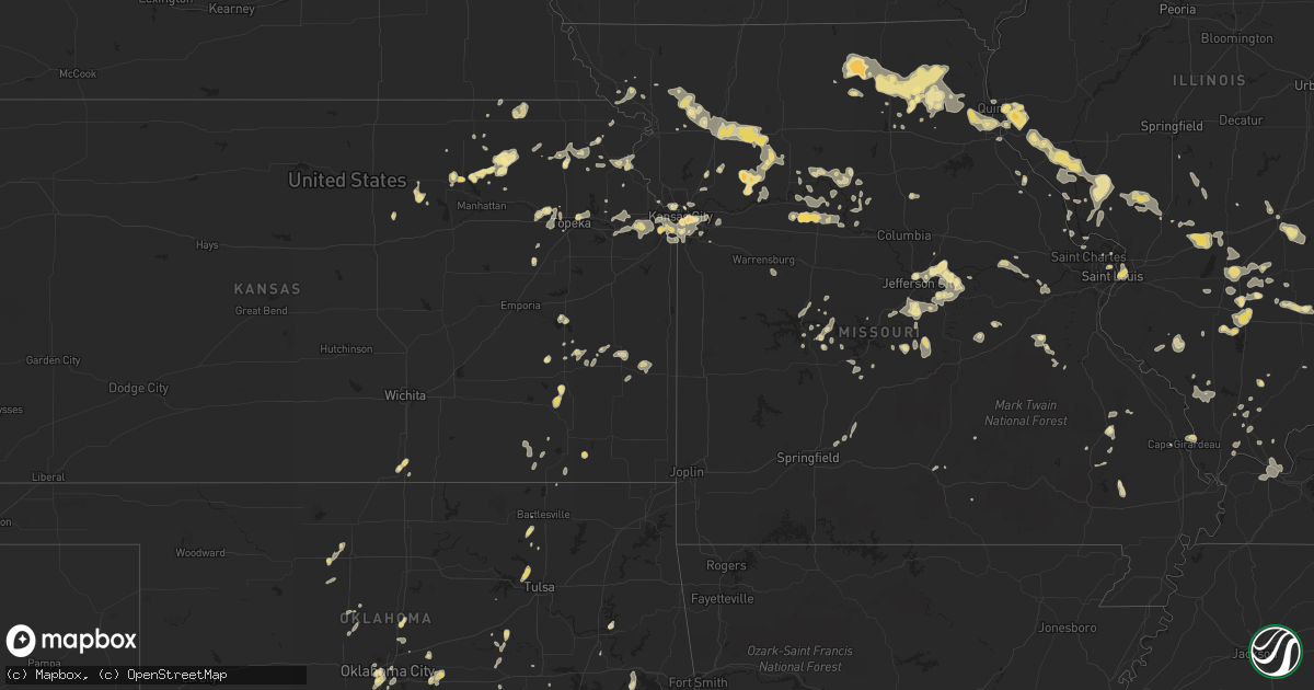
Hail Map in Colorado on July 12, 2011
Get this storm
July 12 map
$229
one time, instant access
Download today. No call, no setup
Keep the $229
Bought the map and want the full workflow? Apply the entire $229 to a subscription within 7 days. None of it is wasted.
Every map, not just this one
This buys you this map. Subscription and you get every map we run, in the markets you choose from a few cities to whole states to nationwide. Plus real-time alerts the moment a storm fires.
Contact data
Name, contact info, occupancy, even credit band for addresses in the footprint. You go from where it hit to who to call.
Become the source they trust
Unlimited branding weather history reports on demand. You already have the documented answer ready for the property owner, and you are the one who showed up with it.
Property data and RoofTrace estimates
Pull up any address you have got, its value and the exact code rules for that jurisdiction, straight from One Click Code. Then RoofTrace estimates the squares, pitch, and roof value, priced the way you price.
Storm reports in Colorado
Colorado
| Date | Description |
|---|---|
| 07/12/20115:41 PM CDT | A local report indicates 1.00 inch wind near 3 W KIOWA |
| 07/12/20115:32 PM CDT | A local report indicates 1.25 inch wind near 5 SE ELIZABETH |
| 07/12/20115:23 PM CDT | A local report indicates 1.00 inch wind near 5 SE ELIZABETH |
| 07/11/201110:55 PM CDT | Denver international airport |
| 07/11/201110:54 PM CDT | A local report indicates 59 MPH wind near DENVER |
| 07/11/201110:54 PM CDT | Large tree blown down at 114th and chambers |
| 07/11/201110:05 PM CDT | A local report indicates 1.00 inch wind near 4 ESE ELBERT |
| 07/11/20119:42 PM CDT | A local report indicates 1.75 inch wind near ELBERT |
| 07/11/20119:11 PM CDT | A local report indicates a tornado near FONDIS |
| 07/11/20119:11 PM CDT | A local report indicates a tornado near ELIZABETH |
| 07/11/20118:59 PM CDT | A local report indicates 1.00 inch wind near 2 S CARPENTER |
| 07/11/20118:24 PM CDT | A local report indicates a tornado near 10 SW AGATE |
| 07/11/20117:52 PM CDT | A local report indicates 1.75 inch wind near 14 W AGATE |
All States Impacted by Hail Map on July 12, 2011
Cities Impacted by Hail Map on July 12, 2011
- Mount Eden, KY
- Lawrenceburg, KY
- Lewisport, KY
- Hawesville, KY
- Philpot, KY
- Moran, KS
- Elbert, CO
- Briggsdale, CO
- Grover, CO
- Blackwater, MO
- Nelson, MO
- Colorado Springs, CO
- Peyton, CO
- Kiowa, CO
- Elizabeth, CO
- Calhan, CO
- Liberty, MS
- Carrollton, MO
- Shelbyville, MO
- Park City, KY
- Wakefield, KS
- Alexandria, TN
- Liberty, TN
- Richmond, MO
- Hardin, MO
- Frankfort, KS
- Onaga, KS
- Westmoreland, KS
- Green City, MO
- Novinger, MO
- Green Castle, MO
- Payson, IL
- Quincy, IL
- Liberty, IL
- Plainville, IL
- Hillsdale, WY
- Burns, WY
- Carpenter, WY
- Cheyenne, WY
- Brighton, CO
- Baxter, TN
- Bloomington Springs, TN
- Cookeville, TN
- Granville, TN
- Buffalo Valley, TN
- Gainesboro, TN
- Hartsburg, MO
- Holts Summit, MO
- Jefferson City, MO
- Woodbury, TN
- Ganado, AZ
- Van Buren, AR
- Rudy, AR
- Cedarville, AR
- Creal Springs, IL
- Kansas City, MO
- Shelbyville, KY
- Whitefish, MT
- Winchester, KY
- Paris, KY
- Circleville, KS
- Gallion, AL
- Newbern, AL
- Greensboro, AL
- Marquand, MO
- South Haven, KS
- Vega, TX
- Bonnieville, KY
- Munfordville, KY
- Tullahoma, TN
- Buffalo, KS
- Yates Center, KS
- Fredonia, KS
- Shawnee, KS
- Lenexa, KS
- Boonville, IN
- Jonesboro, IL
- Cape Girardeau, MO
- McClure, IL
- Carlinville, IL
- Chesterfield, IL
- Shipman, IL
- Franklin, MO
- New Franklin, MO
- Fordsville, KY
- Falls Of Rough, KY
- Olaton, KY
- Huntland, TN
- Louisiana, MO
- Watson, IL
- Effingham, IL
- Dieterich, IL
- Palmyra, MO
- Moundville, AL
- Smithville, TN
- Mcminnville, TN
- Drummond, OK
- Ames, OK
- Morgantown, KY
- Jetson, KY
- De Soto, IL
- Murphysboro, IL
- Sallis, MS
- Cabool, MO
- Greensburg, LA
- Leadore, ID
- Smiths Grove, KY
- Lucas, KY
- Scottsville, KY
- Glasgow, KY
- Alvaton, KY
- Oakland, KY
- Bowling Green, KY
- Reynolds Station, KY
- Salem, IL
- Odin, IL
- Atlanta, GA
- Sumner, IL
- Oblong, IL
- Eaton, CO
- Windsor, CO
- Marion Junction, AL
- Uniontown, AL
- Okeechobee, FL
- Brooksville, MS
- Greenville, MO
- Marshfield, MO
- Strafford, MO
- Burlington, KS
- Lebo, KS
- Iberia, MO
- Crocker, MO
- Norborne, MO
- Polo, MO
- Bethlehem, KY
- Lockport, KY
- Owenton, KY
- Pleasureville, KY
- Woodlawn, IL
- Mount Vernon, IL
- Waltonville, IL
- Iuka, IL
- Bluford, IL
- Texico, IL
- Hamilton, MO
- Goldsmith, TX
- Camp Point, IL
- Winslow, IN
- Oklahoma City, OK
- Box Elder, MT
- Perry, KS
- Oskaloosa, KS
- Jonesboro, GA
- Stockbridge, GA
- Morrow, GA
- Niangua, MO
- Conway, MO
- Gamaliel, KY
- Lafayette, TN
- Red Boiling Springs, TN
- Wellington, KS
- Cameron, MO
- Kidder, MO
- Allen, KS
- Eskridge, KS
- Harveyville, KS
- Battletown, KY
- Neosho Falls, KS
- Le Roy, KS
- Liberty, MO
- Kearney, MO
- Fountain Run, KY
- Holland, KY
- Philipsburg, MT
- Wellston, OK
- Luther, OK
- Bronson, KS
- Redfield, KS
- Uniontown, KS
- Mapleton, KS
- Barnsdall, OK
- Kirksville, MO
- Lincoln, MT
- Montgomery, IN
- Washington, IN
- Petersburg, IN
- Otwell, IN
- Louisville, KY
- Chestnut Mound, TN
- Elmwood, TN
- Carthage, TN
- Whitleyville, TN
- Pleasant Shade, TN
- Cloverport, KY
- Pisgah, AL
- Muskogee, OK
- Oktaha, OK
- Scheller, IL
- Ashley, IL
- Topeka, KS
- Vance, AL
- McCalla, AL
- Oneonta, AL
- Blountsville, AL
- Fulton, MO
- Tebbetts, MO
- New Bloomfield, MO
- Mokane, MO
- Olsburg, KS
- Jerseyville, IL
- Grafton, IL
- Dow, IL
- Boaz, AL
- Shawnee, OK
- Meeker, OK
- Mcloud, OK
- Warrenton, MO
- Marthasville, MO
- Hermann, MO
- Toomsuba, MS
- Sullivan, MO
- Bogard, MO
- Boligee, AL
- Livingston, AL
- Iola, KS
- Piqua, KS
- Salisbury, MO
- Keytesville, MO
- Novelty, MO
- Plantersville, AL
- Maplesville, AL
- Brush Creek, TN
- Prattville, AL
- Eugene, MO
- Eldon, MO
- Clay Center, KS
- Longford, KS
- Brinktown, MO
- Dixon, MO
- Lexington, KY
- Keenesburg, CO
- Hudson, CO
- Bennett, CO
- Deer Trail, CO
- Agate, CO
- Sawyerville, AL
- Akron, AL
- Peetz, CO
- Dale, IN
- Westphalia, MO
- Freeburg, MO
- Saint Thomas, MO
- Presque Isle, ME
- Caribou, ME
- Washburn, ME
- Hardyville, KY
- Horse Cave, KY
- Jackson, MS
- Clinton, MS
- Mulberry Grove, IL
- Smithboro, IL
- Greenville, IL
- Minneapolis, KS
- Scooba, MS
- Whitwell, TN
- Raynesford, MT
- Waldron, MO
- Center, KY
- Greensburg, KY
- Vine Grove, KY
- Fe Warren Afb, WY
- Stigler, OK
- Limestone, ME
- Bartlesville, OK
- Harrodsburg, KY
- Morrisonville, IL
- Nokomis, IL
- Mount Vernon, IN
- Raleigh, MS
- Mize, MS
- Taylorsville, MS
- Cecilia, KY
- Rineyville, KY
- Rayville, LA
- Oakland City, IN
- Fowler, IL
- Monterey, TN
- Chamois, MO
- Adger, AL
- Overland Park, KS
- Prairie Village, KS
- Mission, KS
- Blackburn, MO
- Malta Bend, MO
- Marshall, MO
- Waddy, KY
- Forest City, MO
- Fillmore, MO
- Oregon, MO
- Maitland, MO
- Clinton, LA
- Mount Washington, KY
- Taylorsville, KY
- Atlanta, MO
- Lees Summit, MO
- Independence, MO
- Kingfisher, OK
- Quemado, NM
- Safford, AL
- Sedan, KS
- Longton, KS
- Glasgow, MO
- Armstrong, MO
- Tarzan, TX
- Lawrence, KS
- De Soto, KS
- Bonner Springs, KS
- Tonganoxie, KS
- Linwood, KS
- Lawson, MO
- Saint Francis, ME
- Robinson, IL
- Greeley, CO
- Savannah, GA
- La Belle, MO
- Ewing, MO
- Ventress, LA
- Jarreau, LA
- Rougon, LA
- Glynn, LA
- Epps, LA
- Grantville, KS
- Chinook, MT
- Tanner, AL
- Georgetown, LA
- Harvest, AL
- Athens, AL
- Guthrie, OK
- Rossville, KS
- Silver Lake, KS
- Pall Mall, TN
- Jamestown, TN
- Meriden, KS
- Pittsfield, IL
- Skiatook, OK
- Tulsa, OK
- Sand Springs, OK
- Lahoma, OK
- Hannibal, MO
- Rome, IN
- Warsaw, MO
- Gallatin, MO
- Braymer, MO
- Breckenridge, MO
- Ludlow, MO
- Williamsburg, KY
- Puxico, MO
- Eutaw, AL
- Upton, KY
- Knox City, MO
- Edina, MO
- Newark, MO
- Okemah, OK
- Fort Branch, IN
- Owensville, IN
- Princeton, IN
- New Raymer, CO
- Pearl, IL
- Hodgenville, KY
- Wadesville, IN
- Evansville, IN
- Fayette, MS
- Bastrop, LA
- Frankfort, KY
- Pittsburg, IL
- Thompsonville, IL
- Pawnee, IL
- Pioneer, LA
- Colony, KS
- Ault, CO
- Pierce, CO
- Everest, KS
- Meno, OK
- Cannelton, IN
- Leawood, KS
- Hampton, AR
- Erwinville, LA
- Conyers, GA
- Derby, IN
- Tell City, IN
- Leopold, IN
- Belknap, IL
- Grantsburg, IL
- Kellyton, AL
- Alexander City, AL
- Fort Gibson, OK
- Muscotah, KS
- Whiting, KS
- Horton, KS
- Falls City, NE
- Maple Hill, KS
- French Camp, MS
- Grain Valley, MO
- Buckner, MO
- Oak Grove, MO
- Dawn, MO
- Hanceville, AL
- Cherryvale, KS
- Hermitage, AR
- Barry, IL
- Holton, KS
- Preston, MS
- Leonardville, KS
- Bonnots Mill, MO
- Billingsley, AL
- Saint Louis, MO
- Sturgeon, MO
- Clark, MO
- Centralia, MO
- Wann, OK
- Sweet Springs, MO
- Poseyville, IN
- Franktown, CO
- Ackerly, TX
- Chester, AR
- Natural Dam, AR
- Osborn, MO
- Maysville, MO
- Kaycee, WY
- Golconda, IL
- East Helena, MT
- Clancy, MT
- Waverly, KS
- Bethel, MO
- Jasper, IN
- Faunsdale, AL
- East Saint Louis, IL
- Lovejoy, IL
- Madison, IL
- Willow Springs, MO
- Crane Hill, AL
- Finchville, KY
- Simpsonville, KY
- Vandalia, IL
- Cave City, KY
- Lynnville, IN
- Tennyson, IN
- Cottondale, AL
- Bosworth, MO
- Kuttawa, KY
- Birch Tree, MO
- Knob Lick, KY
- Laramie, WY
- Norris City, IL
- Rutledge, MO
- Baring, MO
- Gibbs, MO
- Brashear, MO
- Hurdland, MO
- La Plata, MO
- Leonard, MO
- Flat Rock, AL
- South Pittsburg, TN
- Coxs Creek, KY
- Clermont, KY
- Shepherdsville, KY
- Amity, MO
- King City, MO
- Union Star, MO
- Florissant, MO
- Westview, KY
- Hudson, KY
- Leitchfield, KY
- Linn, MO
- Graham, MO
- Brownsville, KY
- Edwards, MO
- Climax Springs, MO
- Bonnie, IL
- Du Bois, IL
- Marysville, KS
- Blue Rapids, KS
- Pikeville, KY
- Miami, MO
- Maywood, MO
- Taylor, MO
- Durham, MO
- Morrison, MO
- Summer Shade, KY
- Tompkinsville, KY
- Hayneville, AL
- Elk City, KS
- Xenia, IL
- Sandoval, IL
- Alma, IL
- Patoka, IL
- Kinmundy, IL
- Byrdstown, TN
- Summerville, GA
- Eldridge, MO
- Cuba, MO
- Rosebud, MO
- Owensville, MO
- Ethel, MO
- New Boston, MO
- West Salem, IL
- Mount Erie, IL
- Golden Gate, IL
- Bone Gap, IL
- Albion, IL
- Fairdale, KY
- Brooks, KY
- Lebanon Junction, KY
- Wamego, KS
- Branchville, IN
- Loogootee, IN
- Crane, IN
- Wartrace, TN
- Hingham, MT
- English, IN
- Leavenworth, IN
- Elsberry, MO
- Clarksville, MO
- Annada, MO
- Nunn, CO
- Galeton, CO
- Gill, CO
- Duncanville, AL
- Brent, AL
- Centreville, AL
- Lamesa, TX
- Carrier, OK
- Fisherville, KY
- Edmonton, KY
- Medora, IL
- Gillespie, IL
- Mount Olive, IL
- Litchfield, IL
- Rockbridge, IL
- Mentone, AL
- Bessemer, AL
- Ramah, CO
- Chaplin, KY
- Willisburg, KY
- Bloomfield, KY
- Magnolia, KY
- Canmer, KY
- Clewiston, FL
- Elizabethtown, KY
- Pulaski, MS
- Slater, MO
- Gilliam, MO
- Terreton, ID
- Loose Creek, MO
- West Blocton, AL
- Woodstock, AL
- Sparta, IL
- Cutler, IL
- Coulterville, IL
- Monarch, MT
- Neihart, MT
- Emelle, AL
- Epes, AL
- Carrollton, IL
- White Hall, IL
- Greenfield, IL
- Kell, IL
- Augusta, MO
- Washington, MO
- Labadie, MO
- Arab, AL
- Bland, MO
- Saint James, MO
- Galatia, IL
- Kincaid, KS
- Strasburg, CO
- Brussels, IL
- Golden Eagle, IL
- Whitesville, KY
- Hattiesburg, MS
- Roggen, CO
- Saint Charles, MO
- Big Clifty, KY
- Clarkson, KY
- Roach, MO
- Camdenton, MO
- Macks Creek, MO
- Bagdad, KY
- Bristow, OK
- Garrison, MT
- New Roads, LA
- Castle, OK
- Boley, OK
- Flora, MS
- Shumway, IL
- Clarksville, TN
- Holt, MO
- Brunswick, MO
- De Witt, MO
- Camden, MS
- Albertville, AL
- Roy, MT
- Fort Collins, CO
- Stevenson, AL
- Eastview, KY
- Henley, MO
- Saint Elizabeth, MO
- Meta, MO
- Riverside, MO
- Vermillion, KS
- Lucerne, CO
- McDaniels, KY
- Caneyville, KY
- Hartford, KY
- Hardinsburg, KY
- Crystal Springs, MS
- Hope Hull, AL
- Bridgeport, IL
- Forkland, AL
- Walshville, IL
- Claremont, IL
- Macon, MS
- Columbus, MS
- Crawford, MS
- Tecumseh, OK
- Karnak, IL
- Ullin, IL
- Arcadia, OK
- Edmond, OK
- Senoia, GA
- Burchard, NE
- Beattie, KS
- Summerfield, KS
- Helmville, MT
- Vincennes, IN
- Lawrenceville, IL
- Atchison, KS
- Fredericktown, MO
- Cross Timbers, MO
- Bonner, MT
- Odon, IN
- Sharpsburg, GA
- Sterling, CO
- Iliff, CO
- Milan, MO
- Dix, IL
- Kansas City, KS
- Rocky Mount, MO
- Baileyville, KS
- Axtell, KS
- Seneca, KS
- Orrville, AL
- Grant, AL
- Guntersville, AL
- Hamburg, IL
- Effingham, KS
- Fairfield, IL
- New Haven, KY
- Auxier, KY
- East Point, KY
- Huntingburg, IN
- Lancaster, KS
- Rushville, MO
- Cummings, KS
- Hillview, IL
- Campbellsburg, KY
- Turners Station, KY
- Easton, KS
- Gurley, AL
- Paducah, KY
- Witt, IL
- Alma, MO
- Dixon Springs, TN
- Fayette, MO
- Lamar, IN
- Santa Claus, IN
- New Canton, IL
- Winchester, IL
- New Salem, IL
- Pleasant Hill, IL
- Rickman, TN
- Livingston, TN
- Centralia, IL
- Hoyleton, IL
- Tallapoosa, GA
- Bremen, GA
- Sylacauga, AL
- Dowelltown, TN
- Hilger, MT
- Lincoln, MO
- Cole Camp, MO
- Hereford, TX
- New Burnside, IL
- Ozark, IL
- Elizabeth, IN
- West Point, KY
- Payneville, KY
- Pinckneyville, IL
- Tamaroa, IL
- Mount Carmel, IL
- Roundhill, KY
- Scottsboro, AL
- Wetmore, KS
- Elora, TN
- Estillfork, AL
- Percy, IL
- Rex, GA
- Beecher City, IL
- Hamburg, AR
- Leeton, MO
- Knob Noster, MO
- Warrensburg, MO
- Salem, MO
- Bolckow, MO
- Enid, OK
- Sherwood, TN
- Bowling Green, MO
- Easton, MO
- Stewartsville, MO
- Dalton, MO
- Venice, IL
- Granite City, IL
- Huntsville, AL
- Vienna, IL
- Goreville, IL
- Mannford, OK
- Johnsonville, IL
- Solomon, KS
- Saint Anthony, IN
- Brookport, IL
- West Paducah, KY
- Metropolis, IL
- Midway, KY
- Eldred, IL
- Winston, MO
- Mooresville, MO
- Uniontown, KY
- Corydon, KY
- Depew, OK
- Gordonsville, TN
- Louisville, MS
- Wrights, IL
- Birdseye, IN
- Eckerty, IN
- Heber, AZ
- Jellico, TN
- Hennessey, OK
- Wiggins, MS
- Brooklyn, MS
- Lumberton, MS
- Guston, KY
- Muldraugh, KY
- Laconia, IN
- Fort Knox, KY
- Ekron, KY
- Radcliff, KY
- Brandenburg, KY
- Cullman, AL
- Readyville, TN
- Batchtown, IL
- Foley, MO
- Geff, IL
- Sims, IL
- Chattanooga, TN
- Sperry, OK
- Eagle Lake, ME
- Netawaka, KS
- Powhattan, KS
- Hobson, MT
- Carr, CO
- Jones, OK
- Weatherby, MO
- Rea, MO
- Rayville, MO
- Kingston, MO
- Clinton, MT
- Coffeyville, KS
- Independence, KS
- Belvidere, TN
- Vian, OK
- Forest, MS
- Horton, AL
- Kane, IL
- Ten Sleep, WY
- Tuscaloosa, AL
- Coker, AL
- Buhl, AL
- Crawford, TN
- Purvis, MS
- Marion, IL
- Fayetteville, GA
- Corning, KS
- Goff, KS
- Brumley, MO
- Trout, LA
- Dover, OK
- Campbellsville, KY
- Garfield, KY
- Baylis, IL
- Kampsville, IL
- Nebo, IL
- Fieldon, IL
- Lithonia, GA
- Cowden, IL
- Carrier Mills, IL
- Velpen, IN
- Grand Chain, IL
- Ferdinand, IN
- Benton, MS
- Patoka, IN
- Sidney, NE
- Eufaula, OK
- Okmulgee, OK
- Prestonsburg, KY
- Morganfield, KY
- Willow Hill, IL
- Dundas, IL
- West Liberty, IL
- Walnut Hill, IL
- Van Buren, ME
- Harned, KY
- Custer, KY
- Geyser, MT
- Bethany, OK
- Falkville, AL
- Walsh, IL
- Richwoods, MO
- Potosi, MO
- Centreville, MS
- Gloster, MS
- Moselle, MS
- Petal, MS
- Louisville, IL
- Ingraham, IL
- Newton, IL
- Wheeler, IL
- Winfield, MO
- Hagerhill, KY
- Clarksdale, MO
- Pritchett, CO
- Greenleaf, KS
- Wilder, TN
- Waverly, KY
- Randolph, KS
- Lewistown, MO
- Philadelphia, MO
- Greentop, MO
- Wyaconda, MO
- Haubstadt, IN
- Stendal, IN
- Francisco, IN
- Saint Croix, IN
- Holland, IN
- Bristow, IN
- Elberfeld, IN
- Lincoln City, IN
- Cynthiana, IN
- Evanston, IN
- Union Star, KY
- Saint Meinrad, IN
- Wilmore, KY
- Lodi, MO
- Patterson, MO
- Silva, MO
- New Market, AL
- Rocky Hill, KY
- Patton, MO
- Hampton, GA
- Centralia, KS
- Stover, MO
- Fort Payne, AL
- Rainsville, AL
- Panama, IL
- Sorento, IL
- Carbondale, IL
- Triplett, MO
- Montreal, MO
- Covington, GA
- Ava, IL
- Irvington, KY
- White Sulphur Springs, MT
- Macon, MO
- Anabel, MO
- Commerce City, CO
- Henderson, CO
- Waco, GA
- Quinton, AL
- Parrish, AL
- Wewoka, OK
- Hillsboro, IL
- Donnellson, IL
- Saint Agatha, ME
- Frenchville, ME
- Winchester, TN
- Elk Horn, KY
- Flintville, TN
- Grayville, IL
- Makanda, IL
- Pomona, IL
- Havre, MT
- Oakman, AL
- Hollytree, AL
- Nauvoo, AL
- Carbon Hill, AL
- Sturgis, KY
- Crossville, AL
- Troy, KS
- Robinson, KS
- Highland, KS
- Millwood, KY
- Luthersville, GA
- Andrews, TX
- Grandview, MO
- Cannelburg, IN
- Austin, KY
- Home, KS
- Shobonier, IL
- Vernon, IL
- Brookwood, AL
- Lewistown, MT
- Fort Lupton, CO
- Keenes, IL
- Altoona, AL
- Madison, AL
- Mineral Point, MO
- Soldier, KS
- Moyock, NC
- Porterville, MS
- Okarche, OK
- Troy, IN
- Koeltztown, MO
- Gracemont, OK
- Sylvania, AL
- Valhermoso Springs, AL
- Hollywood, AL
- Saint Francisville, IL
- Belfry, KY
- Rinard, IL
- Demopolis, AL


