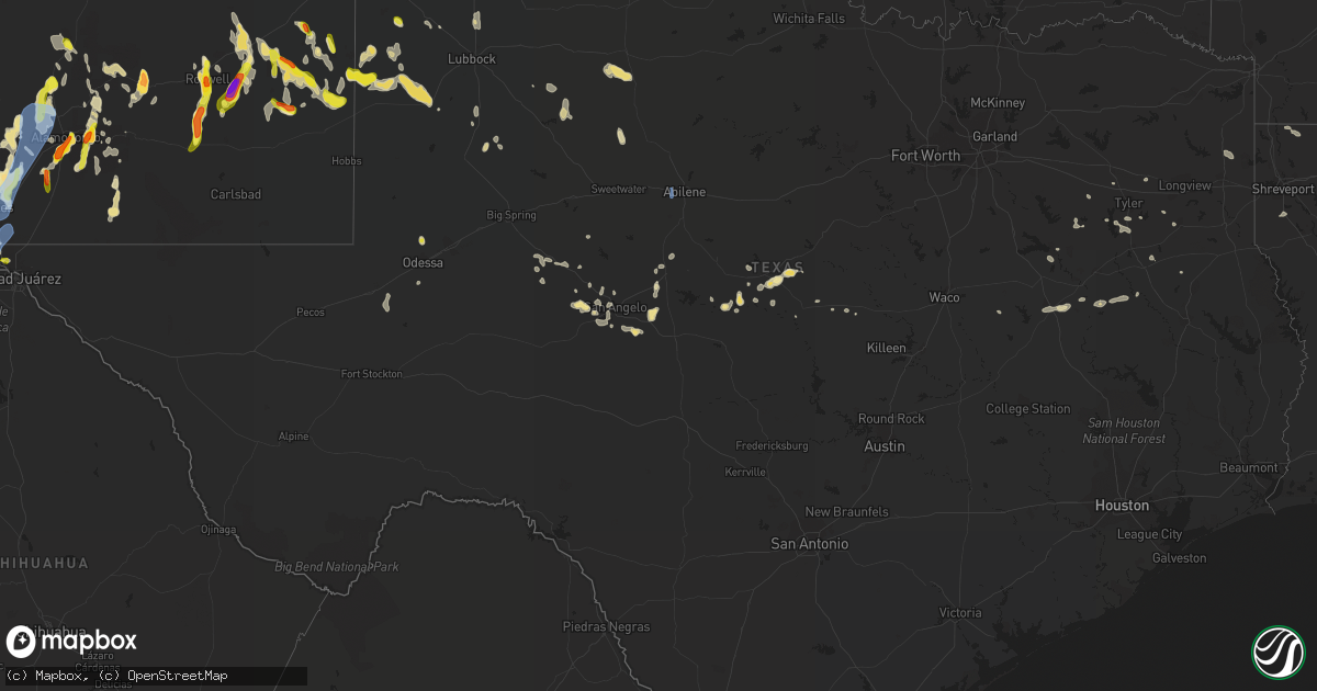
Hail Map in Texas on July 11, 2021
Get this storm
July 11 map
$229
one time, instant access
Download today. No call, no setup
Keep the $229
Bought the map and want the full workflow? Apply the entire $229 to a subscription within 7 days. None of it is wasted.
Every map, not just this one
This buys you this map. Subscription and you get every map we run, in the markets you choose from a few cities to whole states to nationwide. Plus real-time alerts the moment a storm fires.
Contact data
Name, contact info, occupancy, even credit band for addresses in the footprint. You go from where it hit to who to call.
Become the source they trust
Unlimited branding weather history reports on demand. You already have the documented answer ready for the property owner, and you are the one who showed up with it.
Property data and RoofTrace estimates
Pull up any address you have got, its value and the exact code rules for that jurisdiction, straight from One Click Code. Then RoofTrace estimates the squares, pitch, and roof value, priced the way you price.
Storm reports in Texas
Texas
| Date | Description |
|---|---|
| 07/11/20215:15 PM CDT | Photo and public report of ping pong ball sized hail in valentine. Post office verified time. |
| 07/11/20212:25 PM CDT | A local report indicates 65 MPH wind near 8 WSW SUNDOWN |
| 07/11/20217:23 AM CDT | At 1223 AM CDT, severe thunderstorms were located along a line extending from 5 miles west of Chattanooga to 4 miles northeast of Sugden to 6 miles southeast of Milo, moving southeast at 25 mph. HAZARD...60 mph wind gusts and penny size hail. SOURCE...Trained weather spotters estimated 60 mph winds near Comanche. IMPACT...Expect damage to roofs, siding, and trees. Locations impacted include... Northwestern Wichita Falls, Ardmore, Burkburnett, Marietta, Walters, Waurika, Lone Grove, Healdton, Wilson, Dickson, Grandfield, Ringling, Temple, Ryan, Springer, Petrolia, Byers, Dean, Chattanooga and Thackerville. |
| 07/11/20217:03 AM CDT | At 1203 PM MDT, a severe thunderstorm was located near Tatum, moving southeast at 25 mph. HAZARD...60 mph wind gusts and half dollar size hail. SOURCE...Radar indicated. IMPACT...Hail damage to vehicles is expected. Expect wind damage to roofs, siding, and trees. Locations impacted include... Tatum, McDonald, Gladiola and Tatum Airport. |
| 07/11/20217:02 AM CDT | At 1202 AM CDT, severe thunderstorms were located along a line extending from 3 miles south of Olney to near Lehigh to 7 miles east of Coalgate, moving southeast at 45 mph. HAZARD...60 mph wind gusts and penny size hail. SOURCE...Radar indicated. IMPACT...Expect damage to roofs, siding, and trees. Locations impacted include... Atoka, Coalgate, Stringtown, Lehigh, Tushka, Caney, Lane, Phillips, Atoka Reservoir, Bentley, McGee Creek Lake, Boggy Depot Park and Darwin. |
| 07/11/20213:11 AM CDT | At 811 PM MDT, severe thunderstorms were located along a line extending from 3 miles northeast of Northeast El Paso to Canutillo to 8 miles southeast of Afton, moving southeast at 55 mph. HAZARD...70 mph wind gusts and ping pong ball size hail. SOURCE...Radar indicated. IMPACT...People and animals outdoors will be injured. Expect hail damage to roofs, siding, windows, and vehicles. Expect considerable tree damage. Wind damage is also likely to mobile homes, roofs, and outbuildings. Locations impacted include... West El Paso, East El Paso, Central El Paso, Northeast El Paso, Far East El Paso, Mission Valley, Tornillo, Fabens, Clint, Horizon City, Santa Teresa, Anthony, Sunland Park, Indian Cliffs Ranch, Canutillo, San Elizario, Vinton, Westway, Fort Bliss and Socorro.This includes Interstate 10 in Texas between mile markers 1 and 56. |
| 07/11/20212:58 AM CDT | At 757 PM CDT, a severe thunderstorm was located 11 miles north of Odessa, moving southwest at 20 mph. HAZARD...60 mph wind gusts and quarter size hail. SOURCE...Radar indicated. IMPACT...Hail damage to vehicles is expected. Expect wind damage to roofs, siding, and trees. Locations impacted include... Odessa, West Odessa, Odessa Schlemeyer Field, Penwell and Pleasant Farms.This includes Interstate 20 between mile markers 99 and 123. |
| 07/11/20212:31 AM CDT | At 730 PM MDT, severe thunderstorms were located along a line extending from 7 miles northeast of Afton to near Anthony Gap to 19 miles east of McGregor Range Base, moving southwest at 35 mph. Near zero visibility is possible from blowing dust ahead of the rain. HAZARD...70 mph wind gusts and penny size hail. SOURCE...Radar indicated. IMPACT...Expect considerable tree damage. Damage is likely to mobile homes, roofs, and outbuildings. Locations impacted include... West El Paso, East El Paso, Central El Paso, Northeast El Paso, Far East El Paso, Mission Valley, Chaparral, Loma Linda, Clint, Horizon City, Santa Teresa, Anthony, Desert Haven, Hueco Tanks, Vado, Sunland Park, Canutillo, Afton, San Elizario and Anthony Gap.This includes the following highways... Interstate 10 in New Mexico between mile markers 157 and 164. Interstate 10 in Texas between mile markers 1 and 46. Highway 54 in New Mexico between mile markers 1 and 5. |
| 07/11/20212:01 AM CDT | At 701 AM CDT, a severe thunderstorm was located over Dyess AFB, moving south at 20 mph. HAZARD...70 mph wind gusts and quarter size hail. SOURCE...Radar indicated. IMPACT...Hail damage to vehicles is expected. Expect considerable tree damage. Wind damage is also likely to mobile homes, roofs, and outbuildings. This severe thunderstorm will be near... View around 710 AM CDT. Buffalo Gap around 720 AM CDT. Tuscola around 735 AM CDT. Lawn around 745 AM CDT.Other locations impacted by this severe thunderstorm include LakeAbilene, Ovalo and Camp Tonkawa.This includes Interstate 20 between Mile Markers 276 and 280. |
| 07/11/20211:59 AM CDT | At 658 PM CDT, a severe thunderstorm was located near Valentine, or 30 miles northwest of Marfa, and is nearly stationary. HAZARD...60 mph wind gusts and quarter size hail. SOURCE...Radar indicated. IMPACT...Hail damage to vehicles is expected. Expect wind damage to roofs, siding, and trees. Locations impacted include... Valentine. |
| 07/11/20211:57 AM CDT | At 656 PM CDT, a severe thunderstorm was located 12 miles southeast of Monahans, moving south at 10 mph. HAZARD...60 mph wind gusts and quarter size hail. SOURCE...Radar indicated. IMPACT...Hail damage to vehicles is expected. Expect wind damage to roofs, siding, and trees. Locations impacted include... Grandfalls, Royalty, Imperial, Imperial Reservoir and Cordona Lake. |
| 07/11/20211:57 AM CDT | At 657 PM CDT, a severe thunderstorm was located over Twin Buttes Reservoir, and is nearly stationary. HAZARD...60 mph wind gusts. SOURCE...Radar indicated. IMPACT...Expect damage to roofs, siding, and trees. This severe thunderstorm will be near... Lake Nasworthy around 800 PM CDT. |
| 07/11/20211:54 AM CDT | At 654 PM MDT, severe thunderstorms were located along a line extending from near Dell City to 12 miles north of Cornudas to 13 miles northeast of Loma Linda, moving south at 10 mph. HAZARD...60 mph wind gusts. SOURCE...Radar indicated. IMPACT...Expect damage to roofs, siding, and trees. Locations impacted include... Dell City, Cornudas, Salt Flat and Cornudas Mountains. |
| 07/11/20211:35 AM CDT | At 635 PM CDT, a severe thunderstorm was located 11 miles southwest of Bloys Camp, or 13 miles northwest of Marfa, moving southwest at 20 mph. HAZARD...60 mph wind gusts and quarter size hail. SOURCE...Radar indicated. IMPACT...Hail damage to vehicles is expected. Expect wind damage to roofs, siding, and trees. This severe thunderstorm will remain over mainly rural areas of north central Presidio County. |
| 07/11/20211:11 AM CDT | At 611 PM CDT, a severe thunderstorm was located near Vancourt, and another was located near Eola. Both storms were nearly stationary. HAZARD...60 mph wind gusts and quarter size hail. SOURCE...Radar indicated. IMPACT...Hail damage to vehicles is expected. Expect wind damage to roofs, siding, and trees. This severe thunderstorm will be near... Vancourt around 700 PM CDT.Other locations impacted by this severe thunderstorm include Vick. |
| 07/11/20211:08 AM CDT | At 608 PM MDT, a severe thunderstorm was located 24 miles northwest of Dell City, moving south at 35 mph. HAZARD...Two inch hail and 60 mph wind gusts. SOURCE...Radar indicated. IMPACT...People and animals outdoors will be injured. Expect hail damage to roofs, siding, windows, and vehicles. Expect wind damage to roofs, siding, and trees. Locations impacted include... Dell City and Cornudas Mountains. |
| 07/11/20211:01 AM CDT | At 601 PM CDT, a severe thunderstorm was located over Valentine, or 33 miles northwest of Marfa, moving southwest at 5 mph. HAZARD...60 mph wind gusts and quarter size hail. SOURCE...Radar indicated. IMPACT...Hail damage to vehicles is expected. Expect wind damage to roofs, siding, and trees. Locations impacted include... Valentine. |
| 07/10/202111:24 PM CDT | At 423 AM CDT, a severe thunderstorm was located over O'brien, moving south at 30 mph. HAZARD...60 mph wind gusts and penny size hail. SOURCE...Radar indicated. IMPACT...Expect damage to roofs, siding, and trees. This severe thunderstorm will be near... Rochester around 430 AM CDT. Weinert around 435 AM CDT. Rule around 450 AM CDT. Haskell around 455 AM CDT. Paint Creek around 515 AM CDT. Stamford and Lake Stamford Marina around 520 AM CDT.Other locations impacted by this severe thunderstorm include Jud, Us-277 Near The Haskell-Knox County Line and Us-380 Near The Haskell-Stonewall County Line. |
| 07/10/202111:08 PM CDT | At 407 AM CDT, a severe thunderstorm was located over Fort Griffin, moving south at 40 mph. HAZARD...60 mph wind gusts. SOURCE...Radar indicated. IMPACT...Expect damage to roofs, siding, and trees. This severe thunderstorm will be near... Albany around 430 AM CDT. Moran around 450 AM CDT.Other locations impacted by this severe thunderstorm include BigCountry Baptist Assembly, Mccarty Lake, Us-283 Near The Callahan-Shackelford County Line and Us-180 Near The Shackelford-Stephens County Line. |
| 07/10/202111:08 PM CDT | At 408 AM CDT, a severe thunderstorm was located 7 miles southwest of Benjamin, moving south at 20 mph. HAZARD...60 mph wind gusts and penny size hail. SOURCE...Radar indicated. IMPACT...Expect damage to roofs, siding, and trees. Locations impacted include... Knox City and Benjamin. |
| 07/10/202110:33 PM CDT | At 333 AM CDT, a severe thunderstorm was located near Throckmorton, moving south at 35 mph. HAZARD...70 mph wind gusts. SOURCE...Radar indicated. IMPACT...Expect considerable tree damage. Damage is likely to mobile homes, roofs, and outbuildings. This severe thunderstorm will be near... Throckmorton around 345 AM CDT.Other locations impacted by this severe thunderstorm include Lusk,Us-183 Near The Throckmorton-Baylor County Line, The Intersection Of Us-183 And Us-283, The Intersection Of Us-283 And Ranch Road 209 and The Intersection Of Us-380 And Highway 222. |
| 07/10/202110:25 PM CDT | At 325 PM CDT, a severe thunderstorm was located near Brownfield, moving southeast at 30 mph. HAZARD...70 mph wind gusts and nickel size hail. SOURCE...Radar indicated. IMPACT...Expect considerable tree damage. Damage is likely to mobile homes, roofs, and outbuildings. Locations impacted include... Brownfield. |
| 07/10/202110:12 PM CDT | At 312 PM CDT, a severe thunderstorm was located 11 miles southeast of Kalgary, or 14 miles south of White River Lake, moving southeast at 20 mph. HAZARD...70 mph wind gusts and nickel size hail. SOURCE...Radar indicated. IMPACT...Expect considerable tree damage. Damage is likely to mobile homes, roofs, and outbuildings. Locations impacted include... Lake Alan Henry. |
| 07/10/20219:58 PM CDT | At 257 AM CDT, severe thunderstorms were located along a line extending from 13 miles northwest of Truscott to 3 miles north of Vera to 7 miles south of Mabelle, moving south at 30 mph. HAZARD...60 mph wind gusts. SOURCE...Radar indicated. IMPACT...Expect damage to roofs, siding, and trees. Locations impacted include... Seymour, Munday, Knox City, Crowell, Benjamin, Goree, Red Springs, Gilliland, Bomarton, Lake Kemp, Mabelle, Vera, Truscott and Rhineland. |
| 07/10/20219:56 PM CDT | At 255 PM CDT, a severe thunderstorm was located over Bula, or 14 miles northeast of Morton, moving southwest at 25 mph. HAZARD...70 mph wind gusts and quarter size hail. SOURCE...Radar indicated. IMPACT...Hail damage to vehicles is expected. Expect considerable tree damage. Wind damage is also likely to mobile homes, roofs, and outbuildings. Locations impacted include... Enochs, Pep and Bula. |
| 07/10/20219:49 PM CDT | At 249 PM CDT, a severe thunderstorm was located 7 miles south of Sundown, or 17 miles southwest of Levelland, moving east at 30 mph. HAZARD...70 mph wind gusts and quarter size hail. SOURCE...Radar indicated. IMPACT...Hail damage to vehicles is expected. Expect considerable tree damage. Wind damage is also likely to mobile homes, roofs, and outbuildings. Locations impacted include... Sundown and Locketville. |
| 07/10/20219:35 PM CDT | Several reports of hail across west el paso of up to 1.25 inches. Sources are trained spotters... Nws employees... And public. |
| 07/10/20219:15 PM CDT | Numerous reports of trees down and several inch tree branches across west el paso. |
| 07/10/20219:10 PM CDT | Downed tree covering road. Time estimated. |
| 07/10/20219:05 PM CDT | At 205 AM CDT, severe thunderstorms were located along a line extending from 7 miles southwest of Goodlett to 6 miles east of Margaret to near Grayback, moving south at 30 mph. HAZARD...60 mph wind gusts. SOURCE...Radar indicated. IMPACT...Expect damage to roofs, siding, and trees. Locations impacted include... Vernon, Seymour, Crowell, Benjamin, Goree, Red Springs, Thalia, Gilliland, Bomarton, Margaret, Lockett, Lake Kemp, Mabelle, Vera, Medicine Mound, Oklaunion, Truscott, Grayback, Rhineland and Rayland. |
| 07/10/20219:00 PM CDT | Tree fell on house in canutillo. |
| 07/10/20218:54 PM CDT | At 154 PM CDT, a severe thunderstorm was located 14 miles north of Plains, moving southeast at 25 mph. HAZARD...70 mph wind gusts and quarter size hail. SOURCE...Radar indicated. IMPACT...Hail damage to vehicles is expected. Expect considerable tree damage. Wind damage is also likely to mobile homes, roofs, and outbuildings. This severe thunderstorm will remain over mainly rural areas of southern Cochran, northwestern Terry, southwestern Hockley and northeastern Yoakum Counties. |
| 07/10/20218:53 PM CDT | At 153 AM CDT, the leading edge of winds from a line of severe thunderstorms was located along a line extending from 6 miles southeast of Grayback to 3 miles northwest of Mankins to 4 miles southeast of Iowa Park, moving south at 40 mph. HAZARD...70 mph wind gusts. SOURCE...The public measured a 70 mph wind gust northeast of Electra. IMPACT...Expect considerable tree damage. Damage is likely to mobile homes, roofs, and outbuildings. Locations impacted include... Archer City, Holliday, Scotland, Megargel, Mabelle, Lake Diversion, Dundee, Mankins, Westover, Lake Kickapoo and Lakeside City. |
| 07/10/20218:04 PM CDT | Pea to quarter size hail. |
All States Impacted by Hail Map on July 11, 2021
Cities Impacted by Hail Map on July 11, 2021
- Chino Valley, AZ
- Dewey, AZ
- Prescott Valley, AZ
- Prescott, AZ
- Rockwood, TX
- Roswell, NM
- Lovington, NM
- Tatum, NM
- Milnesand, NM
- Las Cruces, NM
- White Sands Missile Range, NM
- San Angelo, TX
- Roy, NM
- Mills, NM
- Springer, NM
- Elida, NM
- Hamlin, TX
- Rotan, TX
- Cut Bank, MT
- Cuba, NM
- Thoreau, NM
- Crownpoint, NM
- Tinnie, NM
- Picacho, NM
- Lindrith, NM
- Morton, TX
- Vadito, NM
- Penasco, NM
- La Mesa, NM
- Anthony, NM
- Vado, NM
- Mesquite, NM
- Zephyr, TX
- Dexter, NM
- Alamogordo, NM
- Hagerman, NM
- Lake Arthur, NM
- Big Sandy, MT
- Galata, MT
- Lothair, MT
- Chester, MT
- Joplin, MT
- Odonnell, TX
- Henderson, TX
- Kevin, MT
- Shelby, MT
- Amherst, TX
- Enochs, TX
- Dickens, TX
- Aspermont, TX
- Paducah, TX
- Plain Dealing, LA
- Cloudcroft, NM
- Lindale, TX
- Jemez Springs, NM
- Los Alamos, NM
- Crane, TX
- El Paso, TX
- Carrizozo, NM
- Grants, NM
- Cubero, NM
- Rusk, TX
- Wagon Mound, NM
- Brookesmith, TX
- Robert Lee, TX
- Holloman Air Force Base, NM
- Plains, TX
- Comanche, TX
- Williams, AZ
- Abernathy, TX
- Counselor, NM
- La Jara, NM
- Sterling City, TX
- Inverness, MT
- Mescalero, NM
- Paint Rock, TX
- Mereta, TX
- Eola, TX
- Datil, NM
- Rudyard, MT
- Tularosa, NM
- Truth Or Consequences, NM
- Derry, NM
- San Carlos, AZ
- Cimarron, NM
- Post, TX
- Vaughn, NM
- Santa Anna, TX
- Brownwood, TX
- Weed, NM
- Buffalo, TX
- Mertzon, TX
- Payson, AZ
- Vancourt, TX
- Odessa, FL
- Tampa, FL
- La Luz, NM
- Sacramento, NM
- Lawrenceville, VA
- Emporia, VA
- Dunnellon, FL
- Rochelle, TX
- Gardendale, TX
- Glencoe, NM
- Snyder, TX
- Oakwood, TX
- Swainsboro, GA
- Fort Benton, MT
- Hingham, MT
- Mayhill, NM
- Mechanicsburg, PA
- Carlisle, PA
- Grapeland, TX
- Marysville, PA
- Duncannon, PA
- Hondo, NM
- Capitan, NM
- San Patricio, NM
- Lincoln, NM
- Levelland, TX
- Brownfield, TX
- Meadow, TX
- Camp Hill, PA
- Athens, TX
- Gallina, NM
- Whiteface, TX
- Ballinger, TX
- Berino, NM
- Chamberino, NM
- Santa Fe, NM
- Early, TX
- Ruidoso Downs, NM
- Ruidoso, NM
- Frierson, LA
- Stonewall, LA
- Gloster, LA
- Jacksonville, TX
- Rowena, TX
- Lamesa, TX
- Clifton, AZ
- Norton, TX
- Hatch, NM
- Bangs, TX
- Socorro, NM
- Tahoka, TX
- Organ, NM
- Seligman, AZ
- Troup, TX
- Flint, TX
- Bullard, TX
- Crossroads, NM
- Santa Teresa, NM
- Ben Wheeler, TX
- Whitehouse, TX
- Tyler, TX
- Winters, TX
- Williston, FL
- Bronson, FL
- Gouldbusk, TX
- Buckhorn, NM
- Blanket, TX
- Larue, TX
- Gail, TX
- Nacogdoches, TX
- Salem, NM
- Lyons, GA
- Great Cacapon, WV
- Goldthwaite, TX
- Mesilla Park, NM
- Nogal, NM
- Ranchos De Taos, NM
- Jefferson, TX
- Carlsbad, TX
- Fairfield, TX
- Evant, TX
- Pinon, NM
- Mullin, TX
- Halifax, PA
- Little Orleans, MD
- Flintstone, MD
- Anton, TX
- Hope, NM
- Winona, TX
- Gatesville, TX
- Four Oaks, NC
- Justiceburg, TX
- Thornton, TX
- Tarpon Springs, FL
- New Port Richey, FL
- Odessa, TX
- Overton, TX
- Chandler, TX
- Anthony, TX
- Canutillo, TX
- Rock Island, TN
- Littlefield, TX
- Newport, PA
- McAlisterville, PA
- Thompsontown, PA
- Saxton, PA
- James Creek, PA
- Chaparral, NM
- Abilene, TX
- Tye, TX
- Box Elder, MT
- Havre, MT
- Madison, AL
- New Market, AL
- Huntsville, AL
- Artesia, NM
- Pep, NM
- Karthaus, PA
- Pottersdale, PA
- Lewisburg, PA
- Beavertown, PA
- Mifflinville, PA
- Catawissa, PA
- Mifflintown, PA
- McClure, PA
- Nescopeck, PA
- Shamokin Dam, PA
- New Berlin, PA
- Beaver Springs, PA
- Sunbury, PA
- Middleburg, PA
- Selinsgrove, PA
- Riverside, PA
- Paxinos, PA
- Bloomsburg, PA
- Richfield, PA
- Danville, PA
- Winfield, PA
- Mifflinburg, PA
- Northumberland, PA
- Lemoyne, PA
- New Cumberland, PA
- Harrisburg, PA


