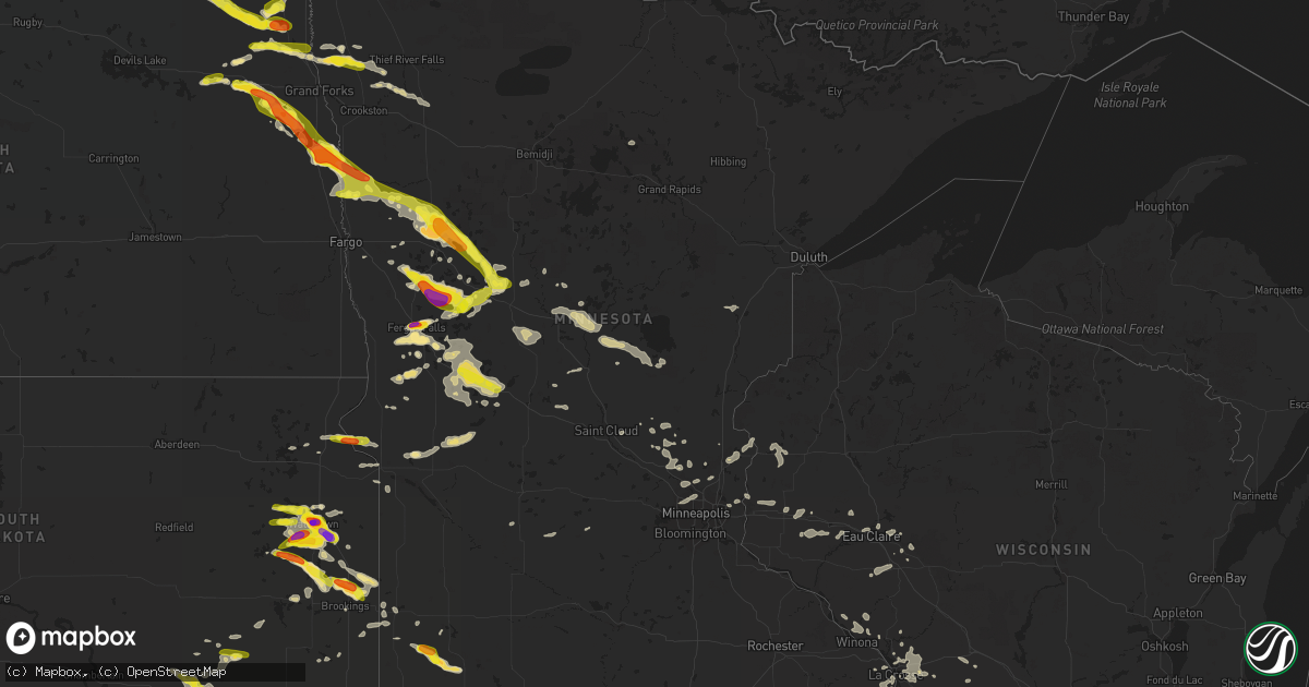
Hail Map in Minnesota on July 11, 2017
Get this storm
July 11 map
$229
one time, instant access
Download today. No call, no setup
Keep the $229
Bought the map and want the full workflow? Apply the entire $229 to a subscription within 7 days. None of it is wasted.
Every map, not just this one
This buys you this map. Subscription and you get every map we run, in the markets you choose from a few cities to whole states to nationwide. Plus real-time alerts the moment a storm fires.
Contact data
Name, contact info, occupancy, even credit band for addresses in the footprint. You go from where it hit to who to call.
Become the source they trust
Unlimited branding weather history reports on demand. You already have the documented answer ready for the property owner, and you are the one who showed up with it.
Property data and RoofTrace estimates
Pull up any address you have got, its value and the exact code rules for that jurisdiction, straight from One Click Code. Then RoofTrace estimates the squares, pitch, and roof value, priced the way you price.
Storm reports in Minnesota
Minnesota
| Date | Description |
|---|---|
| 07/11/20176:45 PM CDT | Hail for 10 minutes with varying sizes up to the size of ping pong balls |
| 07/11/20176:40 PM CDT | Hail shredded corn and bean fields |
| 07/11/20176:32 PM CDT | Dime to quarter sized hail fell west of northcote |
| 07/11/20179:25 AM CDT | A local report indicates 1.25 inch wind near 7 SW WENDELL |
| 07/11/20172:57 AM CDT | Trees down. |
| 07/11/20172:48 AM CDT | Trees down. |
| 07/11/20172:48 AM CDT | Trees and power lines down. Time estimated. |
| 07/11/20172:44 AM CDT | Numerous trees down reported via facebook. |
| 07/11/20172:43 AM CDT | Trees down. |
| 07/11/20172:42 AM CDT | Trees down. |
| 07/11/20172:40 AM CDT | Trees and power lines down. Time estimated. |
| 07/11/20172:39 AM CDT | Trees down. |
| 07/11/20172:38 AM CDT | Trees down... Time estimated. |
| 07/11/20172:35 AM CDT | Trees down... Time estimated. |
| 07/11/20172:33 AM CDT | Report with photos on facebook of trees and power-lines down. |
| 07/11/20172:32 AM CDT | Trees on a home and a couple cars. Time estimated. |
| 07/11/20172:30 AM CDT | Numerous pine trees down along kettle river blvd. Photo on facebook. |
| 07/11/20172:30 AM CDT | Numerous large trees down oak and pine. Power out many areas. Boats flipped and docks twisted on area lakes. Covers tri-county area. Between forest lake and wyoming. |
| 07/11/20172:28 AM CDT | Tornado developed along a severe line of storms and caused an attached garage to collapse... Destroyed a couple outbuildings... And produced a concentrated area of heav |
| 07/11/20172:24 AM CDT | Trees and power lines down... Time estimated. |
| 07/11/20172:21 AM CDT | Trees down... Time estimated. |
| 07/11/20172:20 AM CDT | Numerous large oak trees down. Power out. |
| 07/11/20172:16 AM CDT | Trees and power lines down... Time estimated. |
| 07/11/20172:13 AM CDT | Trees down... Time estimated. |
| 07/11/20171:30 AM CDT | 16 ft pine tree blown down. |
| 07/11/201712:39 AM CDT | Time estimated from radar. |
| 07/10/201711:52 PM CDT | Measured 61kt gust. Numerous trees down in alexandria per law enforcement. |
| 07/10/201711:40 PM CDT | Large evergreen tree snapped off at ground. |
| 07/10/201711:19 PM CDT | Barn and corn cribs down. Time estimated from radar. |
| 07/10/201711:15 PM CDT | Large hail along with very heavy rains and strong winds. |
| 07/10/201711:10 PM CDT | Large tree down. |
| 07/10/201711:05 PM CDT | Downed power-lines around bellingham. Many large trees down... And damage to the lac qui parle coutny works garage. |
| 07/10/201711:00 PM CDT | Hail up to ping pong sized between pelican rapids and lake lida. |
| 07/10/201710:45 PM CDT | A local report indicates 1.00 inch wind near 6 NNW PELICAN RAPIDS |
| 07/10/201710:35 PM CDT | A local report indicates 1.00 inch wind near 8 SE BUTLER |
| 07/10/201710:20 PM CDT | The wind gust was measured by a raws station. |
| 07/10/201710:16 PM CDT | A local report indicates 1.00 inch wind near OTTERTAIL |
| 07/10/201710:15 PM CDT | Could have been some a little bigger... But did not go out to look around. |
| 07/10/201710:04 PM CDT | A local report indicates 1.50 inch wind near 6 SSE FERGUS FALLS |
| 07/10/201710:00 PM CDT | Numerous large trees broken down and blocking lanes along u.s. Highway 10 between detroit lakes and frazee. |
| 07/10/20179:58 PM CDT | Large hail and very strong winds between rochert and height of land lake. Trees down all over the place. |
| 07/10/20179:52 PM CDT | Numerous large trees snapped or uprooted around lake sallie... Lake melissa... And the greater detroit lakes area. Roads blocked and power lines down. |
| 07/10/20179:46 PM CDT | The wind gust was measured by a raws station. Time estimated based on radar. Numerous trees snapped or uprooted near floyd lake. One 24x40 shed lifted and collapsed. |
| 07/10/20179:46 PM CDT | Mostly quarter sized to half dollar sized hails... With some hail up to ping pong ball size |
| 07/10/20179:45 PM CDT | Hail ranged in size from 1.50 to 2 inches. Hailed until 950 pm. |
| 07/10/20179:40 PM CDT | A local report indicates 1.00 inch wind near ELBOW LAKE |
| 07/10/20179:39 PM CDT | Very large hail fell for several minutes. |
| 07/10/20179:35 PM CDT | Multiple large trees down. Accompanied by large hail... But did not see the size. Wind speeds estimated at 65 to 70 mph. Local power outages reported. |
| 07/10/20179:35 PM CDT | Large trees broken down around town. Power out. Winds estimated to 80 mph. |
| 07/10/20179:26 PM CDT | Numerous large tree branches and limbs broken down around town. Power lines down. |
| 07/10/20179:25 PM CDT | A local report indicates 1.25 inch wind near 7 SW WENDELL |
| 07/10/20179:10 PM CDT | Emergency mgr reported trees down approximately 1w ulen. Winds estimated at 70-80 miles per hour. Trees downed were approximately 12-18 inches in diameter. Powerlines w |
| 07/10/20178:48 PM CDT | Emergency manager from clay county reports shelf cloud approaching and 60-70 mph winds |
| 07/10/20178:47 PM CDT | Dime to quarter sized hail |
| 07/10/20178:45 PM CDT | The roof was blown off a pole shed and large trees were uprooted. Time estimated from radar. Report via social media. |
| 07/10/20178:42 PM CDT | This tornado tracked to the southeast for roughly 13 miles... Before it curled out around 2 miles north of ulen by 906 pm cdt. This tornado collaspsed at least one shed |
| 07/10/20178:40 PM CDT | This tornado tracked to the southeast for roughly 13 miles... Before it curled out around 2 miles north of ulen by 906 pm cdt. This tornado collaspsed at least on shed. |
| 07/10/20178:25 PM CDT | Report with picture via facebook |
| 07/10/20178:15 PM CDT | A local report indicates 1.00 inch wind near 2 NE DOROTHY |
| 07/10/20178:05 PM CDT | Shed destroyed and numerous trees uprooted. |
| 07/10/20177:23 PM CDT | Hail up to golf ball sized fell across northwest tobor township. |
| 07/10/20177:07 PM CDT | This tornado tracked intermittently for nearly 10 miles across northern northland and tabor townships... And lifted around 3 miles east of tabor by 730 pm cdt. The torn |
All States Impacted by Hail Map on July 11, 2017
Cities Impacted by Hail Map on July 11, 2017
- Elgin, IA
- Saint Olaf, IA
- Elkader, IA
- Elkport, IA
- Volga, IA
- Strawberry Point, IA
- Garnavillo, IA
- Edgewood, IA
- Durango, IA
- Sherrill, IA
- New Vienna, IA
- Garber, IA
- Luxemburg, IA
- Cassville, WI
- Holy Cross, IA
- North Buena Vista, IA
- Guttenberg, IA
- Dubuque, IA
- Greeley, IA
- Colesburg, IA
- Fayette, IA
- West Union, IA
- Frazee, MN
- Oakland, IL
- Waterville, IA
- Harpers Ferry, IA
- Luana, IA
- Postville, IA
- Monona, IA
- Waukon, IA
- Battle Lake, MN
- Dalton, MN
- Fergus Falls, MN
- Saint Thomas, ND
- Saint Vincent, MN
- Pembina, ND
- Hallock, MN
- Drayton, ND
- Lancaster, MN
- Fort White, FL
- Watertown, SD
- Whitestown, IN
- Sheridan, IN
- Correll, MN
- Appleton, MN
- Birmingham, AL
- Mitchell, SD
- Ethan, SD
- Plankinton, SD
- Mount Vernon, SD
- Lewistown, IL
- Chinook, MT
- Havre, MT
- Sundance, WY
- Circle, MT
- Fort Peck, MT
- Malta, MT
- Platteville, WI
- Rewey, WI
- Belmont, WI
- Mineral Point, WI
- Bellbrook, OH
- Spring Valley, OH
- Pisek, ND
- Park River, ND
- Minto, ND
- Milton, ND
- Osnabrock, ND
- Adams, ND
- Edinburg, ND
- Fairdale, ND
- Grafton, ND
- Goodland, KS
- Wallace, KS
- Edson, KS
- Sharon Springs, KS
- Princeton, MN
- Erwin, NC
- Bunnlevel, NC
- Carthage, IL
- Basco, IL
- Bridgman, MI
- Baroda, MI
- Sanderson, FL
- Niagara, ND
- Fall Creek, WI
- Alexis, IL
- Rio, IL
- Galesburg, IL
- Wataga, IL
- Lake Preston, SD
- Arlington, SD
- Johnstown, NE
- Langdon, ND
- Wales, ND
- Rocklake, ND
- Munich, ND
- Alsen, ND
- Calvin, ND
- Staples, MN
- Sebeka, MN
- Round Lake, IL
- Ringwood, IL
- Grayslake, IL
- Ingleside, IL
- Wonder Lake, IL
- Fox Lake, IL
- Mchenry, IL
- Roberts, WI
- New Richmond, WI
- Hudson, WI
- Hammond, WI
- Clinton, MN
- New Port Richey, FL
- Tarpon Springs, FL
- Dent, MN
- Colfax, IN
- Deer River, MN
- Caledonia, MN
- Eitzen, MN
- Vergas, MN
- Pelican Rapids, MN
- Aledo, IL
- Hamilton, GA
- Burtrum, MN
- Eads, CO
- Castlewood, SD
- Bartlett, IL
- Elgin, IL
- Wayne, IL
- Cuba, IL
- Canton, IL
- Forest River, ND
- Henry, SD
- New Palestine, IN
- Indianapolis, IN
- Fairland, IN
- Detroit Lakes, MN
- Callaway, MN
- Petersburg, ND
- Montezuma, IN
- Rockville, IN
- Marshall, IN
- Bloomingdale, IN
- Lake Park, MN
- Lehigh Acres, FL
- La Crosse, WI
- Rockland, WI
- Bangor, WI
- Holmen, WI
- Onalaska, WI
- Mindoro, WI
- West Salem, WI
- Coon Valley, WI
- Kit Carson, CO
- Elm Creek, NE
- Overton, NE
- New York Mills, MN
- Wadena, MN
- Beardsley, MN
- Peever, SD
- Wilmot, SD
- Langeloth, PA
- Atlasburg, PA
- Slovan, PA
- Burgettstown, PA
- Audubon, MN
- Ogema, MN
- Rochert, MN
- Ulen, MN
- Show Low, AZ
- Florence, SD
- Loring, MT
- Whitewater, MT
- Decatur, IL
- Winnebago, IL
- Rockford, IL
- Twin Valley, MN
- Wilton, WI
- Warren, MN
- Doylesburg, PA
- Spring Run, PA
- Dry Run, PA
- Avalon, WI
- Janesville, WI
- Darien, WI
- Whitewater, WI
- Delavan, WI
- Elkhorn, WI
- Clearmont, WY
- Berryville, VA
- Boyce, VA
- Buxton, ND
- Mayville, ND
- Farmersburg, IA
- McGregor, IA
- Middle River, MN
- Little Falls, MN
- Benton Harbor, MI
- Rapid City, SD
- Burke, SD
- Millerville, AL
- Alexander City, AL
- Goodwater, AL
- Ashland, AL
- Brooklyn, WI
- Mount Horeb, WI
- New Glarus, WI
- Belleville, WI
- Blanchardville, WI
- Lead, SD
- McDonald, KS
- Brewster, KS
- Colby, KS
- Warrensburg, IL
- Latham, IL
- Maroa, IL
- Norcross, MN
- Elbow Lake, MN
- Burlington, WI
- Genoa City, WI
- Daviston, AL
- Long Pine, NE
- Richey, MT
- Perley, MN
- Hendrum, MN
- Otterbein, IN
- Attica, IN
- Minneapolis, MN
- Wendell, MN
- White, SD
- Brookings, SD
- Aurora, SD
- Bruce, SD
- Bellingham, MN
- Ada, MN
- Montgomery, AL
- Oil City, PA
- Titusville, PA
- North Liberty, IA
- Tiffin, IA
- Erhard, MN
- Ottertail, MN
- Perham, MN
- Richville, MN
- Glenview, IL
- Winnetka, IL
- Wilmette, IL
- Borup, MN
- Lancaster, WI
- South Elgin, IL
- Hampshire, IL
- Saint Charles, IL
- Larimore, ND
- Campbell, MN
- Ashby, MN
- Hillsboro, ND
- Cashton, WI
- Gillette, WY
- Weston, WY
- Moorcroft, WY
- Estelline, SD
- Shade Gap, PA
- Concord, PA
- Blairs Mills, PA
- Deadwood, SD
- Ramer, AL
- Osseo, WI
- Eleva, WI
- Strum, WI
- Evansville, MN
- Clear Lake, SD
- Hazel, SD
- Hayti, SD
- Goodwin, SD
- Mills, NE
- West Terre Haute, IN
- Paris, IL
- Reynolds, ND
- Northwood, ND
- Thompson, ND
- Hatton, ND
- Ludowici, GA
- Slayton, MN
- Iona, MN
- Chandler, MN
- Pine Mountain Valley, GA
- Fontana, WI
- Lake Geneva, WI
- Talladega, AL
- Lillington, NC
- Piedmont, SD
- Lowry, MN
- Platte, SD
- Geddes, SD
- Chippewa Falls, WI
- Cadott, WI
- Eau Claire, WI
- Winchester, VA
- Brooks, MN
- Plummer, MN
- Livingston, WI
- Tomah, WI
- Bonesteel, SD
- Walhalla, ND
- Neche, ND
- Brainerd, MN
- Fort Ripley, MN
- Libertyville, IL
- Gurnee, IL
- Roachdale, IN
- Villard, MN
- Leeds, AL
- Menahga, MN
- Osage, MN
- Bluffton, MN
- Parkers Prairie, MN
- Kensington, MN
- Clitherall, MN
- Vining, MN
- Garfield, MN
- Brandon, MN
- Farwell, MN
- Osakis, MN
- Nelson, MN
- Miltona, MN
- Alexandria, MN
- Hoffman, MN
- Barrett, MN
- Bryant, SD
- Lake Norden, SD
- Snellville, GA
- Onamia, MN
- Des Plaines, IL
- Skokie, IL
- Morton Grove, IL
- Golf, IL
- Kenilworth, IL
- Northbrook, IL
- Evanston, IL
- Niles, IL
- Summit, SD
- Bloomfield, MT
- Lindsay, MT
- Wolf Point, MT
- Ladoga, IN
- Springview, NE
- Artesian, SD
- Fedora, SD
- Thief River Falls, MN
- Ontario, WI
- Loves Park, IL
- Cheyenne Wells, CO
- Black Hawk, SD
- Alexandria, SD
- Isanti, MN
- Fulda, MN
- Rushville, IN
- Milroy, IN
- Leonard, MI
- Oxford, MI
- Port Charlotte, FL
- Eddyville, NE
- Sumner, NE
- Miller, NE
- Letcher, SD
- Dayton, OH
- Manvel, ND
- Fordville, ND
- Hollandale, WI
- Hector, MN
- Macomb, IL
- Wingate, IN
- Crawfordsville, IN
- Waynetown, IN
- Sarles, ND
- Shullsburg, WI
- Ainsworth, NE
- Bowling Green, IN
- Brazil, IN
- Centerpoint, IN
- Hazel Green, WI
- Cuba City, WI
- Cummings, ND
- Motley, MN
- Nisswa, MN
- Pillager, MN
- Baxter, MN
- Hoople, ND
- Brocton, IL
- Baldwin, WI
- Woodville, WI
- Bassett, NE
- Hayes Center, NE
- Lake Wilson, MN
- Woodstock, MN
- Pierz, MN
- Hillman, MN
- Lake Panasoffkee, FL
- Salem, WI
- Iowa City, IA
- West Liberty, IA
- West Branch, IA
- Toulon, IL
- Speer, IL
- Evansville, WI
- North Branch, MN
- Clarks Hill, IN
- Linden, IN
- New Richmond, IN
- Romney, IN
- Darlington, IN
- Stratton, NE
- Red Lake Falls, MN
- Cedar, MN
- Winfield, IL
- Wheaton, IL
- Genoa, IL
- Glen Ellyn, IL
- Lombard, IL
- Carol Stream, IL
- Sycamore, IL
- Glendale Heights, IL
- Hanover Park, IL
- Burlington, IL
- West Chicago, IL
- Omaha, NE
- Jefferson, WI
- Fort Atkinson, WI
- New Albin, IA
- Eagle Bend, MN
- Bertha, MN
- Hewitt, MN
- Browerville, MN
- Clarissa, MN
- Astoria, SD
- Toronto, SD
- Arvilla, ND
- Mount Hope, WI
- Potosi, WI
- Thorntown, IN
- Frankfort, IN
- Ortonville, MN
- Graceville, MN
- East Grand Forks, MN
- Oslo, MN
- Inkster, ND
- Alpine, AL
- Fairmount, IL
- Indianola, IL
- Catlin, IL
- Browning, IL
- Rotonda West, FL
- Englewood, FL
- Letart, WV
- Moose Lake, MN
- La Valle, WI
- Reedsburg, WI
- Odessa, FL
- Holiday, FL
- Lansing, IA
- Parrish, FL
- Anoka, MN
- Champlin, MN
- Madison, SD
- Chester, SD
- Deerfield, IL
- Greenbush, MN
- Upperstrasburg, PA
- Clinton, WI
- Stillwater, MN
- Lake Elmo, MN
- Columbus, GA
- Hinsdale, MT
- Prairie Du Chien, WI
- Marquette, IA
- Fairfax, SD
- Saint Charles, SD
- Augusta, WI
- Hancock, MN
- Starbuck, MN
- Benson, MN
- Darlington, WI
- Shelbyville, IN
- Payson, AZ
- Pipestone, MN
- Flandreau, SD
- Ruthton, MN
- Elkton, SD
- Myakka City, FL
- Amherst, NE
- Kieler, WI
- Devils Tower, WY
- Ferryville, WI
- Kettle River, MN
- Sturgeon Lake, MN
- Foley, MN
- Lake City, FL
- Hogansville, GA
- Ipava, IL
- Sebring, FL
- Lake Placid, FL
- Hermosa, SD
- Caputa, SD
- Marengo, IL
- Harvard, IL
- Elkhorn, NE
- Bennington, NE
- Hamilton, ND
- Chandlerville, IL
- Hammond, IL
- Wilmont, MN
- Caledonia, ND
- Kennedy, MN
- Fremont, NE
- Parker, PA
- Mundelein, IL
- Vernon Hills, IL
- Knapp, WI
- Immokalee, FL
- Rozet, WY
- Emery, SD
- Williamsfield, IL
- Laura, IL
- Lake Benton, MN
- Smithfield, IL
- Brownsville, MN
- Stoddard, WI
- La Crescent, MN
- Hokah, MN
- Cerro Gordo, IL
- La Place, IL
- Argenta, IL
- Dalton City, IL
- Mt Zion, IL
- Strandburg, SD
- Andover, MN
- Hawley, MN
- Roselle, IL
- Elk Grove Village, IL
- Hoffman Estates, IL
- Schaumburg, IL
- Lincolnwood, IL
- Wheeling, IL
- Lincolnshire, IL
- Highwood, IL
- Arlington Heights, IL
- Lake Zurich, IL
- Park Ridge, IL
- Highland Park, IL
- Prospect Heights, IL
- Mount Prospect, IL
- Buffalo Grove, IL
- Chicago, IL
- Lake Forest, IL
- Glencoe, IL
- Bathgate, ND
- Lone Tree, IA
- Nemo, SD
- Midland, GA
- Cataula, GA
- Fortson, GA
- Hillsboro, WI
- Kendall, WI
- Monticello, WI
- Freeport, MN
- Albany, MN
- Stitzer, WI
- Fennimore, WI
- Huntley, IL
- Pleasantville, PA
- Pecatonica, IL
- Wilson, WI
- Glenwood City, WI
- Pisgah, IA
- Onawa, IA
- Moorhead, IA
- Lagrange, GA
- Kenosha, WI
- Twin Lakes, WI
- Milaca, MN
- Arcola, IL
- Arthur, IL
- Jesup, GA
- Odum, GA
- Palatine, IL
- Naples, FL
- Strathcona, MN
- East Dubuque, IL
- Galena, IL
- Lebanon, IN
- Underwood, MN
- Plymouth, IL
- Augusta, IL
- Garden Prairie, IL
- Upperville, VA
- Houston, MN
- Zimmerman, MN
- Lexington, NE
- Cozad, NE
- Carthage, SD
- Valley, NE
- Morgantown, IN
- Bluemont, VA
- Soldiers Grove, WI
- Blue River, WI
- Greensburg, IN
- Euclid, MN
- Oklee, MN
- Crookston, MN
- Pell City, AL
- Sturgis, SD
- Batesville, IN
- Laurel, IN
- Oldenburg, IN
- Martinsville, IN
- Arlington, IN
- Morristown, IN
- Herman, MN
- Williamsport, IN
- Wonewoc, WI
- Chambersburg, PA
- Fannettsburg, PA
- McConnellsburg, PA
- Fort Loudon, PA
- Big Lake, MN
- Ridgeway, WI
- Dodgeville, WI
- Perrysville, IN
- Cayuga, IN
- Balaton, MN
- Garvin, MN
- Michigan, ND
- Emerado, ND
- Reelsville, IN
- Sabin, MN
- Willow Hill, PA
- Lafayette, AL
- Williams Bay, WI
- Tuckerton, NJ
- Manahawkin, NJ
- Chatsworth, NJ
- Fountain City, WI
- Weskan, KS
- Halstad, MN
- Shelly, MN
- Bird City, KS
- Woonsocket, SD
- Kilbourne, IL
- Easton, IL
- Oquawka, IL
- Seaton, IL
- Suwanee, GA
- Duluth, GA
- Center City, MN
- Shafer, MN
- Saint Croix Falls, WI
- Taylors Falls, MN
- Imler, PA
- Ettrick, WI
- Media, IL
- Vienna, SD
- Willow Lake, SD
- Bronson, MI
- Walworth, WI
- Oakland, MI
- Luthersville, GA
- Alum Bank, PA
- Windber, PA
- Newtown, IN
- Peridot, AZ
- Buford, GA
- Alvarado, MN
- Xenia, OH
- Wyoming, MN
- Saint Cloud, MN
- Danville, OH
- Smithshire, IL
- Kirkwood, IL
- Arcadia, WI
- Barneveld, WI
- Shelton, NE
- Dodge, WI
- Trempealeau, WI
- Kentland, IN
- Lindstrom, MN
- Chisago City, MN
- Stacy, MN
- Corsica, SD
- De Soto, WI
- Carbon, IN
- Hanover, IL
- Elizabeth, IL
- Galesville, WI
- Elk River, MN
- Spring Valley, WI
- Menomonie, WI
- Elmwood, WI
- Bridgewater, SD
- Hutchinson, MN
- Genoa, WI
- Fitzgerald, GA
- La Farge, WI
- Verndale, MN
- Bainbridge, IN
- Glendive, MT
- Bagley, WI
- Peosta, IA
- Glen Haven, WI
- Linden, WI
- Arlington, IA
- Wadena, IA
- Bloomington, WI
- Lakota, ND
- Dumont, MN
- Cochrane, WI
- Bradenton, FL
- Forest Lake, MN
- Circle Pines, MN
- Colfax, WI
- Blomkest, MN
- Little York, IL
- Wentworth, SD
- Grygla, MN
- Gatzke, MN
- Terre Haute, IN
- Rosedale, IN
- Freeman, SD
- Spring Grove, IL
- Monmouth, IL
- Danville, IN
- Pittsboro, IN
- Hannah, ND
- Illiopolis, IL
- Big Stone City, SD
- Turner, MT
- Pine River, MN
- Sturtevant, WI
- Colquitt, GA
- Colman, SD
- Manito, IL
- Milbank, SD
- Bushnell, FL
- Antioch, IL
- Linden, NC
- Rushville, IL
- Littleton, IL
- Trafalgar, IN
- Franklin, IN
- Glenwood, MN
- Wadsworth, IL
- Cooperstown, PA
- Bristol, WI
- North Chicago, IL
- East Troy, WI
- Union Grove, WI
- Milton, WI
- Hebron, IL
- Kansasville, WI
- Palmyra, WI
- Richmond, IL
- Trevor, WI
- Island Lake, IL
- Great Lakes, IL
- Springfield, WI
- Lake Bluff, IL
- Wilmot, WI
- Silver Lake, WI
- Sharon, WI
- Lake Villa, IL
- Woodstock, IL
- Waukegan, IL
- Wauconda, IL
- Barrington, IL
- Baton Rouge, LA
- Ute, IA
- Loris, SC
- Wyoming, IL
- Brownsburg, IN
- Russellville, IN
- Leesburg, GA
- Spring Green, WI
- Plain, WI
- Carpentersville, IL
- Waubun, MN
- Henning, MN
- Harwood, ND
- Grandin, ND
- Barnesville, MN
- Bellevue, IA
- Nineveh, IN
- Nashville, IN
- Albany, WI
- Elk Mound, WI
- Punta Gorda, FL
- Waubay, SD
- Oreana, IL
- Pequot Lakes, MN
- Balsam Lake, WI
- Centuria, WI
- Amery, WI
- Macon, IL
- Benton, WI
- Arapahoe, CO
- Houlton, WI
- Somerset, WI
- Beloit, WI
- North Salem, IN
- Morris, MN
- Holloway, MN
- Colome, SD
- Oxford, IA
- Henderson, IL
- North Henderson, IL
- Viola, IL
- Spearfish, SD
- Hill City, SD
- Hayneville, AL
- Venice, FL
- Fort Stewart, GA
- Hinesville, GA
- Tuscola, IL
- Sturgis, MI
- Burr Oak, MI
- Montfort, WI
- Muscoda, WI
- Cobb, WI
- Highland, WI
- Williston, ND
- New Town, ND
- Watford City, ND
- Epping, ND
- Garden City, SD
- Humboldt, MN
- White Earth, MN


