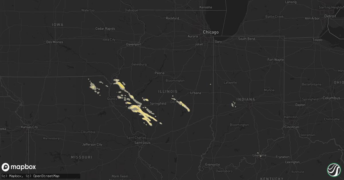
Hail Map in Illinois on July 11, 2015
Get this storm
July 11 map
$229
one time, instant access
Download today. No call, no setup
Keep the $229
Bought the map and want the full workflow? Apply the entire $229 to a subscription within 7 days. None of it is wasted.
Every map, not just this one
This buys you this map. Subscription and you get every map we run, in the markets you choose from a few cities to whole states to nationwide. Plus real-time alerts the moment a storm fires.
Contact data
Name, contact info, occupancy, even credit band for addresses in the footprint. You go from where it hit to who to call.
Become the source they trust
Unlimited branding weather history reports on demand. You already have the documented answer ready for the property owner, and you are the one who showed up with it.
Property data and RoofTrace estimates
Pull up any address you have got, its value and the exact code rules for that jurisdiction, straight from One Click Code. Then RoofTrace estimates the squares, pitch, and roof value, priced the way you price.
Storm reports in Illinois
Illinois
| Date | Description |
|---|---|
| 07/11/20155:18 PM CDT | Delayed report...winds estimated 60-70 mph...time estimated from radar. |
| 07/11/20154:40 PM CDT | Isolated trees down in town and also 4 to 5 miles south of town. |
| 07/11/20154:00 PM CDT | Power lines down on the scottville modesto road. |
| 07/11/20151:56 PM CDT | A local report indicates 63 MPH wind near 3 W POPLAR CITY |
| 07/11/20151:50 PM CDT | Power lines and trees blown down at 1900 n 1400 e. |
| 07/10/201510:10 PM CDT | Delayed report...time estimated. Trees down and some siding off houses. |
| 07/10/201510:02 PM CDT | A local report indicates 62 MPH wind near DECATUR AIRPORT |
| 07/10/20159:15 PM CDT | Trees blown down |
All States Impacted by Hail Map on July 11, 2015
Cities Impacted by Hail Map on July 11, 2015
- Lovington, IL
- Zuni, NM
- Washburn, ND
- Wilton, ND
- Plymouth, IL
- McDonald, KS
- Pawleys Island, SC
- Murrells Inlet, SC
- Claunch, NM
- Corona, NM
- Minnewaukan, ND
- Atwood, KS
- Columbia, NC
- Flaxville, MT
- Laguna, NM
- Cubero, NM
- Cuba, NM
- Ashland, IL
- Virginia, IL
- Saint Francis, KS
- Wray, CO
- Apopka, FL
- Spring Hill, FL
- Crownpoint, NM
- Lakota, ND
- Crary, ND
- Petersburg, ND
- Camp Point, IL
- Clayton, IL
- Voltaire, ND
- Butler, IL
- Winchester, IL
- Hettick, IL
- Greenfield, IL
- Haines City, FL
- Lake Alfred, FL
- Davenport, FL
- Auburndale, FL
- Polk City, FL
- Winter Haven, FL
- Churchs Ferry, ND
- Esmond, ND
- Leeds, ND
- Maddock, ND
- Rugby, ND
- York, ND
- Penn, ND
- Bird City, KS
- Trenton, FL
- Inverness, FL
- Floral City, FL
- Willard, NM
- Havelock, NC
- Arapahoe, NC
- Grantsboro, NC
- Farmington, NM
- Nageezi, NM
- Arvilla, ND
- Emerado, ND
- Vernon, CO
- Idalia, CO
- Devils Lake, ND
- Chesapeake, VA
- Ninety Six, SC
- Saluda, SC
- Roodhouse, IL
- Palmyra, IL
- Murrayville, IL
- Carlinville, IL
- Modesto, IL
- Turtle Lake, ND
- Webster, ND
- Longs, SC
- Little River, SC
- North Myrtle Beach, SC
- Edina, MO
- Rutledge, MO
- Baring, MO
- Maitland, FL
- Altamonte Springs, FL
- Brooksville, FL
- Imperial, NE
- Griggsville, IL
- Girard, IL
- Bluffs, IL
- Waggoner, IL
- Nilwood, IL
- Raymond, IL
- Pittsfield, IL
- Meredosia, IL
- Chesterfield, IL
- Shipman, IL
- Milaca, MN
- Memphis, MO
- Winston, NM
- Argenta, IL
- Cerro Gordo, IL
- Knox City, MO
- Mora, MN
- Ogilvie, MN
- New Salem, IL
- Rushville, IL
- Mount Sterling, IL
- Creswell, NC
- Roper, NC
- Vaughn, NM
- Venango, NE
- Champion, NE
- Medora, IL
- Socorro, NM
- Chatsworth, GA
- Chiefland, FL
- Hammond, IL
- Sullivan, IL
- La Place, IL
- Arthur, IL
- Magdalena, NM
- Fort McCoy, FL
- Pocatello, ID
- Willow City, ND
- Old Town, FL
- Bottineau, ND
- Willcox, AZ
- Gatzke, MN
- Soddy Daisy, TN
- Atlantic Beach, NC
- Powers Lake, ND
- Hill City, KS
- Euclid, MN
- Groveland, FL
- Kahoka, MO
- Saint George, GA
- Hilliard, FL
- Warsaw, IL
- Bowen, IL
- Augusta, IL
- Hamilton, IL
- Carthage, IL
- Basco, IL
- Nauvoo, IL
- Elvaston, IL
- Warrensburg, IL
- Louisville, KY
- East Grand Forks, MN
- Maroa, IL
- Dunseith, ND
- Yeso, NM
- Saint John, ND
- Chocowinity, NC
- Vanceboro, NC
- Lowland, NC
- Aurora, NC
- Hobucken, NC
- Grant, NE
- Grygla, MN
- Timewell, IL
- Calhoun, GA
- Resaca, GA
- Cleveland, TN
- Apison, TN
- Chambersburg, IL
- Jacksonville, IL
- Strathcona, MN
- Middle River, MN
- Oakfield, GA
- Windsor, NC
- Mekinock, ND
- Day, FL
- Loraine, IL
- Tampa, FL
- Sweetwater, TN
- Whitetail, MT
- Coatsburg, IL
- Quincy, IL
- Fowler, IL
- Thatcher, AZ
- Bath, NC
- Washington, NC
- Pinetown, NC
- Andrews, SC
- Baylis, IL
- Mendon, IL
- Golden, IL
- Lancaster, MN
- Niceville, FL
- Colerain, NC
- Jarales, NM
- Kissimmee, FL
- Duncan, AZ
- Pequot Lakes, MN
- Pine River, MN
- Redstone, MT
- La Belle, MO
- Folkston, GA
- Gibsonton, FL
- Grand Forks, ND
- Grand Forks Afb, ND
- Manvel, ND
- Stumpy Point, NC
- Stanley, ND
- Roachdale, IN
- Midway, GA
- Palatka, FL
- Chappells, SC
- Thoreau, NM
- Luray, MO
- Bock, MN
- Pease, MN
- Oak Park, MN
- Foley, MN
- Foreston, MN
- Bowbells, ND
- Longwood, FL
- Lake Mary, FL
- Ruskin, FL
- Ruso, ND
- Webster, FL
- Salvo, NC
- Rodanthe, NC
- Waves, NC
- Wannaska, MN
- Bloomfield, NM
- Egeland, ND
- Perry, IL
- Johnstown, NE
- Eustis, FL
- Verndale, MN
- Georgetown, SC
- Larimore, ND
- Bainbridge, IN
- Ringgold, GA
- Saint Petersburg, FL
- Dade City, FL
- Ashton, ID
- Michigan, ND
- Dalton City, IL
- Mattoon, IL
- Decatur, IL
- Mt Zion, IL
- Humboldt, IL
- Lignite, ND
- Columbus, ND
- Sarasota, FL
- Park Rapids, MN
- Camden, IL
- Huntsville, IL
- La Prairie, IL
- Hawthorne, FL
- Orlando, FL
- Sorrento, FL
- Virginia Beach, VA
- Norfolk, VA
- Portsmouth, VA
- Hillsboro, IL
- Fleming, GA
- Lutz, FL
- Center, ND
- Santa Teresa, NM
- Saint Patrick, MO
- Alexandria, MO
- Newfolden, MN
- Tennessee, IL
- Princeton, MN
- Akeley, MN
- Walker, MN
- Greencastle, IN
- Fillmore, IN
- Rossville, IL
- Lecanto, FL
- Hernando, FL
- Blanding, UT
- Virden, IL
- Franklin, IL
- Waverly, IL
- Blounts Creek, NC
- Bogue, KS
- Turtletown, TN
- Carey, ID
- Dalton, GA
- Jacksonville, FL
- Versailles, IL
- Pearl, IL
- Chapin, IL
- Concord, IL
- Beardstown, IL
- Arenzville, IL
- Gillespie, IL
- White Hall, IL
- Litchfield, IL
- Wyaconda, MO
- Casa Blanca, NM
- Niota, IL
- Nobleton, FL
- Bushnell, FL
- Sealevel, NC
- Atlantic, NC
- Stacy, NC
- Clermont, FL
- Coatesville, IN
- Crosslake, MN
- Williams, MN
- Pima, AZ
- Belhaven, NC
- Lake Bronson, MN
- Clarksville, IN
- New Albany, IN
- Warren, MN
- Forsyth, IL
- Motley, MN
- Staples, MN
- Florahome, FL
- Crookston, MN


